Items Similar to Original Antique Print of People Playing Games in Flanders, Belgium, 1774

Want more images or videos?
Request additional images or videos from the seller
1 of 5
Original Antique Print of People Playing Games in Flanders, Belgium, 1774
About the Item
Antique print titled 'La récréation Flamande'.
Original antique print of people playing games in Flanders, Belgium. Published 1774.
Artists and Engravers: Engraved by Martini after Teniers.
Condition: Fair/good, general age-related toning. Few closed tears, also affecting image. Blank verso. Please study image carefully.
- Dimensions:Height: 12.01 in (30.5 cm)Width: 15.75 in (40 cm)Depth: 0 in (0.02 mm)
- Materials and Techniques:
- Period:1770-1779
- Date of Manufacture:1774
- Condition:Repaired: Condition: Fair/good, general age-related toning. Few closed tears, also affecting image. Blank verso. Please study image carefully. Wear consistent with age and use.
- Seller Location:Langweer, NL
- Reference Number:Seller: BG-06166 1stDibs: LU3054326838592
About the Seller
5.0
Recognized Seller
These prestigious sellers are industry leaders and represent the highest echelon for item quality and design.
Platinum Seller
Premium sellers with a 4.7+ rating and 24-hour response times
Established in 2009
1stDibs seller since 2017
2,417 sales on 1stDibs
Typical response time: <1 hour
- ShippingRetrieving quote...Shipping from: Langweer, Netherlands
- Return Policy
Authenticity Guarantee
In the unlikely event there’s an issue with an item’s authenticity, contact us within 1 year for a full refund. DetailsMoney-Back Guarantee
If your item is not as described, is damaged in transit, or does not arrive, contact us within 7 days for a full refund. Details24-Hour Cancellation
You have a 24-hour grace period in which to reconsider your purchase, with no questions asked.Vetted Professional Sellers
Our world-class sellers must adhere to strict standards for service and quality, maintaining the integrity of our listings.Price-Match Guarantee
If you find that a seller listed the same item for a lower price elsewhere, we’ll match it.Trusted Global Delivery
Our best-in-class carrier network provides specialized shipping options worldwide, including custom delivery.More From This Seller
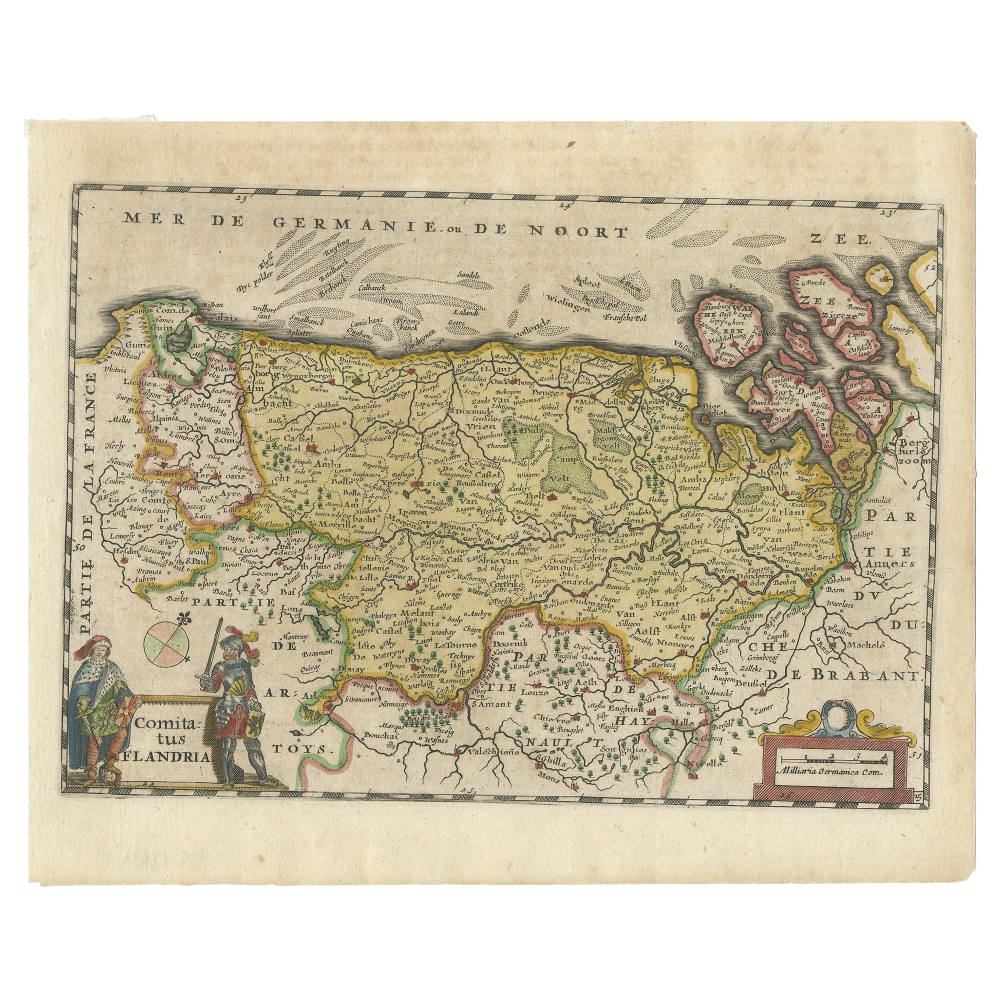
View AllAntique Map of Flanders, Belgium, 1630
Located in Langweer, NL
Antique map titled 'Comitatus Flandria'. Original antique map of Flanders, Belgium. This map originates from 'Vyerige Colom verthonende de 17 Nederlandsche Provintien' published 1630...
Category
Antique 17th Century Maps
Materials
Paper
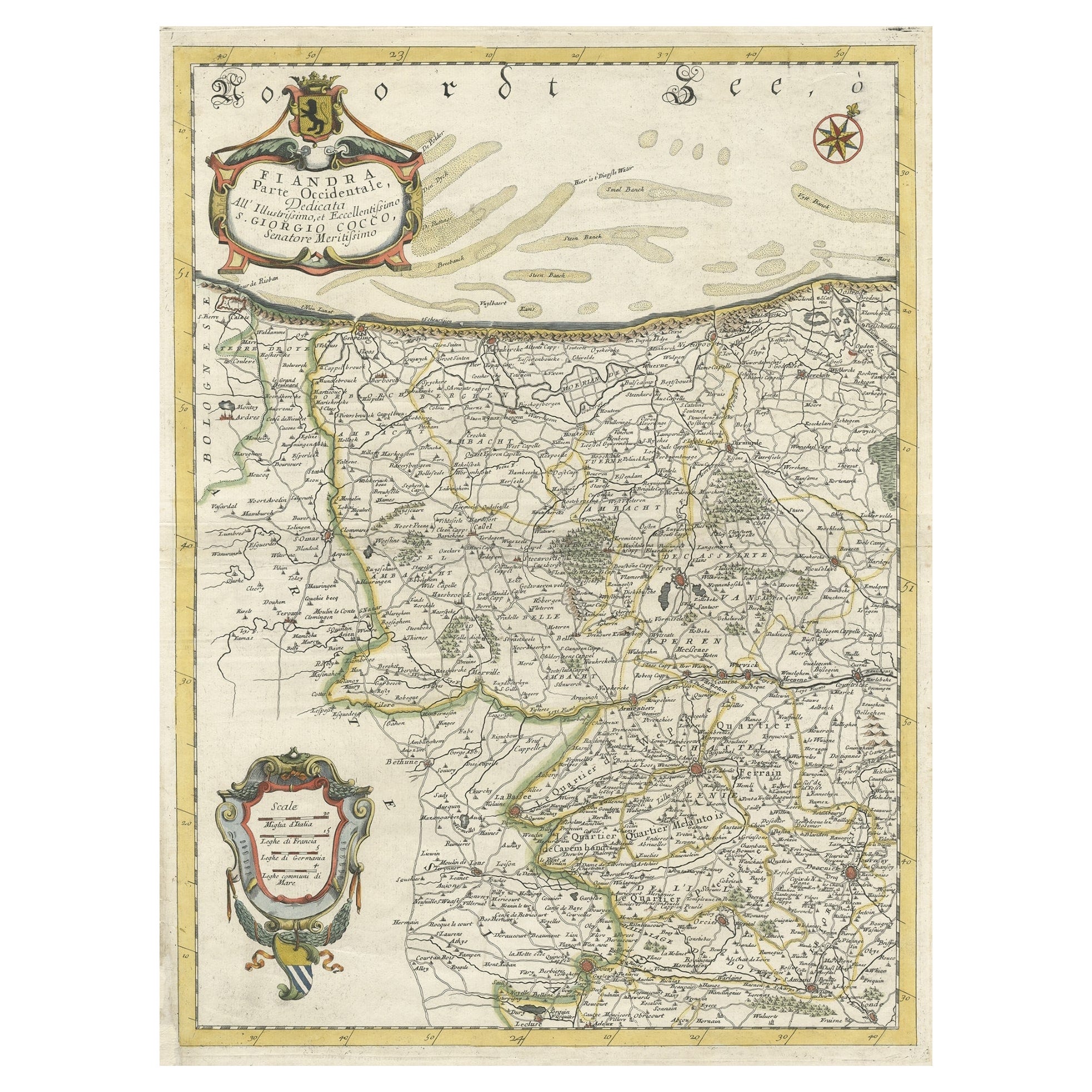
Decorative Original Antique Map of the North of Flanders, Belgium, 1697
Located in Langweer, NL
Antique map titled 'Fiandra Parte Occidentale (..)'.
Depicts northern part of Flanders, from North Sea, extends through the northern region of France to the cities of Douai and V...
Category
Antique 1690s Maps
Materials
Paper
$854 Sale Price
20% Off
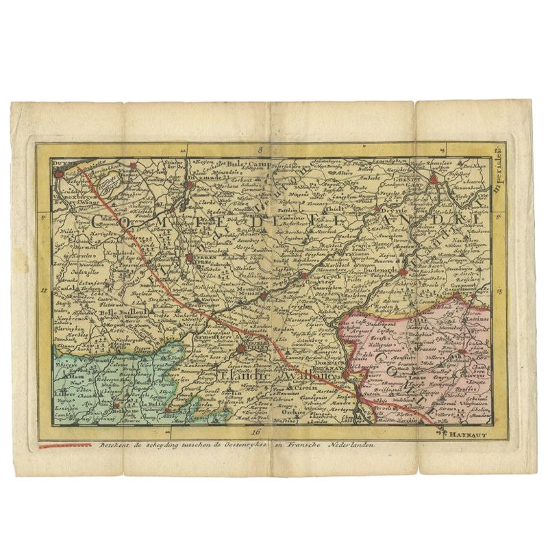
Antique Map of the Region of Flanders in Belgium, 1737
Located in Langweer, NL
Untitled map of the region of Flanders, Belgium. This map originates from 'Nieuw en beknopt Kaart-Boekje vertoonende de XVII. Nederlandse Provintien (..)'.
Artists and Engravers: A...
Category
Antique 18th Century Maps
Materials
Paper

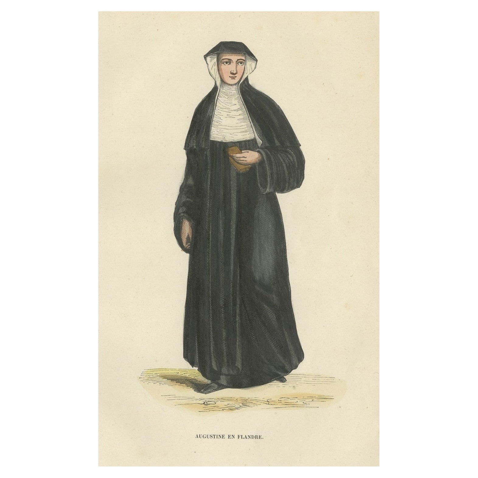
Antique Print of an Augustinian of Flanders, 1845
Located in Langweer, NL
Antique print titled 'Augustine en Flandre'. Print of an Augustinian of Flanders. This print originates from 'Histoire et Costumes des Ordres Religieux'.
Artists and Engravers: Au...
Category
Antique 19th Century Prints
Materials
Paper
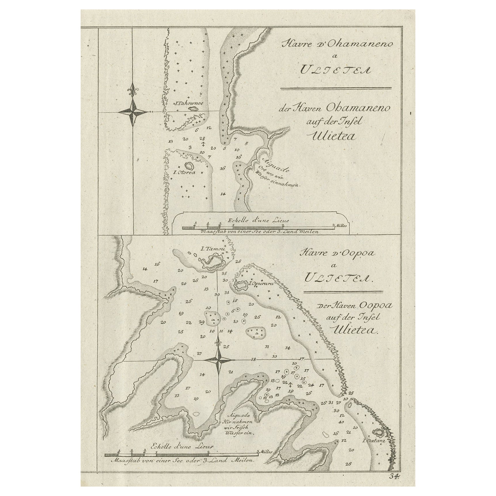
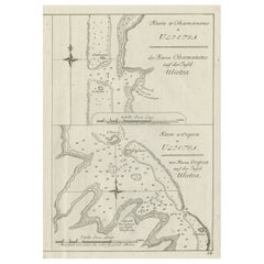
Antique Print of Various Island in French Polynesia, circa 1774
Located in Langweer, NL
Two antique maps on one sheet titled 'Havre d'Ohamaneno a Ulietea' and Havre d'Oopoa a Ulietea'. Also with German subtitles. The upper image depicts Ohamaneno (Vaiaau) Harbour Raiatea (Ulietea) - Leeward Islands...
Category
Antique 18th Century Prints
Materials
Paper
Antique Map of Flanders 'Belgium' by F. de Wit, circa 1680
Located in Langweer, NL
Antique map titled 'Comitatus Flandriae Tabula, in Lucem Edita'. Large map of Flanders, Belgium. Published by F. de Wit, circa 1680.
Category
Antique Late 17th Century Maps
Materials
Paper

$557 Sale Price
20% Off
You May Also Like
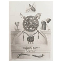
Original Antique Print of Relics of Bonnie Prince Charlie. C.1880
Located in St Annes, Lancashire
Great image of relics belonging to Charles Edward Stuart, Bonnie Prince Charlie
Fine steel engraving by Charles Lawrie
Published by Blackie, Edinburgh,Circa 1880
Unframed.
Category
Antique 1880s English Prints
Materials
Paper
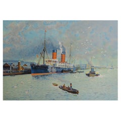
Original Antique Print of R.M.S Campania 'Cunard Line', C.1890
Located in St Annes, Lancashire
Great image of RMS Campania
Chromolithograph
Published C.1890
Unframed.
Category
Antique 1890s English Prints
Materials
Paper
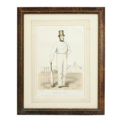
Antique Cricket Print of Joseph Guy of Nottingham
Located in Oxfordshire, GB
Cricket print of Joseph Guy of Nottingham.
A framed, tinted and hand colored lithographic portrait of the All- England cricketer Joseph Guy (1813 - 187...
Category
Antique 1850s British Sporting Art Sports Equipment and Memorabilia
Materials
Paper
Original Antique Map of Europe, Arrowsmith, 1820
Located in St Annes, Lancashire
Great map of Europe
Drawn under the direction of Arrowsmith.
Copper-plate engraving.
Published by Longman, Hurst, Rees, Orme and Brown, 1820
...
Category
Antique 1820s English Maps
Materials
Paper

Original Antique Map of South America. C.1780
Located in St Annes, Lancashire
Great map of South America
Copper-plate engraving
Published C.1780
Two small worm holes to left side of map
Unframed.
Category
Antique Early 1800s English Georgian Maps
Materials
Paper

Original Antique Map of Ireland- Kerry. C.1840
Located in St Annes, Lancashire
Great map of Kerry
Steel engraving
Drawn under the direction of A.Adlard
Published by How and Parsons, C.1840
Unframed.
Category
Antique 1840s English Maps
Materials
Paper
