Items Similar to Capt. Cook Aiming His Gun Near Islands of the New Hebrides, Vanuatu, 1803


Want more images or videos?
Request additional images or videos from the seller
1 of 6
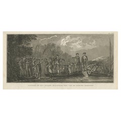
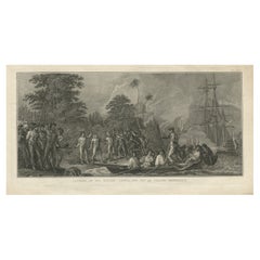
Capt. Cook Aiming His Gun Near Islands of the New Hebrides, Vanuatu, 1803
About the Item
Antique print New Hebrides titled 'Landing op het Eiland Erramanga, een van de Nieuwe Hebriden'.
Antique print depicting the landing at one of the islands of the New Hebrides, Vanuatu. Captain Cook is aiming his gun. Originates from 'Reizen Rondom de Waereld door James Cook (..)'.
Artists and Engravers: Translated by J.D. Pasteur. Published by Honkoop, Allart en Van Cleef.
- Dimensions:Height: 11.82 in (30 cm)Width: 20.67 in (52.5 cm)Depth: 0 in (0.02 mm)
- Materials and Techniques:
- Period:
- Date of Manufacture:1803
- Condition:Wear consistent with age and use. Condition: Good, age-related toning. Some creasing and marginal tears. Please study image carefully.
- Seller Location:Langweer, NL
- Reference Number:Seller: BG-11487-661stDibs: LU3054327258062
About the Seller
5.0
Recognized Seller
These prestigious sellers are industry leaders and represent the highest echelon for item quality and design.
Platinum Seller
Premium sellers with a 4.7+ rating and 24-hour response times
Established in 2009
1stDibs seller since 2017
2,417 sales on 1stDibs
Typical response time: <1 hour
- ShippingRetrieving quote...Shipping from: Langweer, Netherlands
- Return Policy
Authenticity Guarantee
In the unlikely event there’s an issue with an item’s authenticity, contact us within 1 year for a full refund. DetailsMoney-Back Guarantee
If your item is not as described, is damaged in transit, or does not arrive, contact us within 7 days for a full refund. Details24-Hour Cancellation
You have a 24-hour grace period in which to reconsider your purchase, with no questions asked.Vetted Professional Sellers
Our world-class sellers must adhere to strict standards for service and quality, maintaining the integrity of our listings.Price-Match Guarantee
If you find that a seller listed the same item for a lower price elsewhere, we’ll match it.Trusted Global Delivery
Our best-in-class carrier network provides specialized shipping options worldwide, including custom delivery.More From This Seller
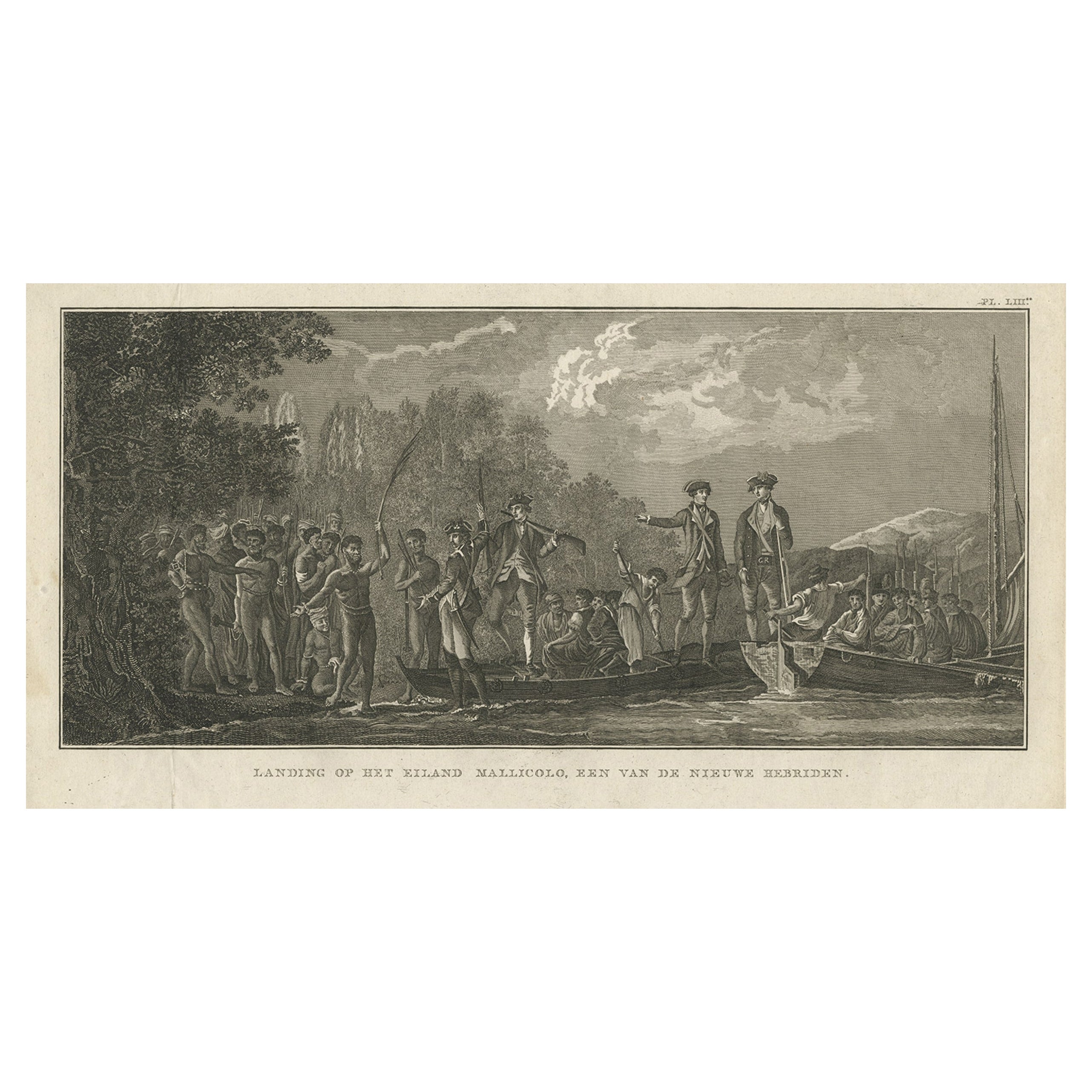
View AllAntique Print of the Landing at Malakula Island, Vanuatu, by Cook, 1803
Located in Langweer, NL
Antique print New Hebrides titled 'Landing op het Eiland Mallicolo, een van de Nieuwe Hebriden'. Antique print depicting the landing at one of the islands of the New Hebrides, Vanuat...
Category
Antique 19th Century Prints
Materials
Paper
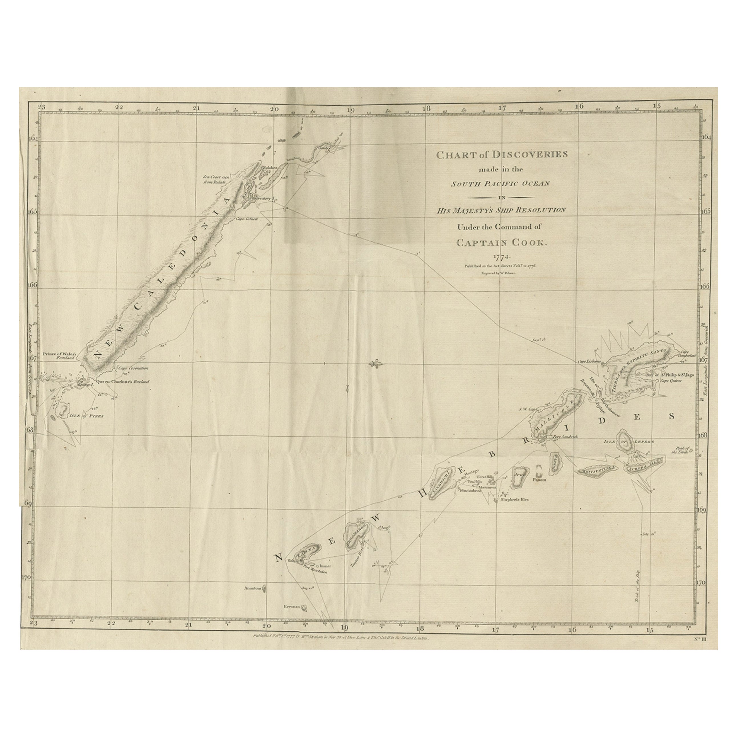
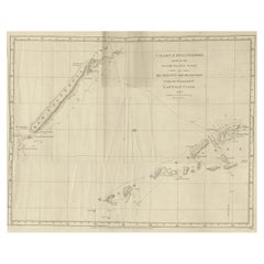
Rare Engraving of New Caledonia & New Hebrides from Capt. Cook's Travels, 1777
Located in Langweer, NL
Antique map titled 'Chart of Discoveries made in the South Pacific Ocean'.
Rare engraving from the official British Admiralty sanctioned edition of the accounts of Cook’s second voyage. All other later copies made of this image by other publishers were unauthorised, usually smaller and inferior in quality. Made after Cook's discovery of the island group on 4 September 1774, which he named New Caledonia...
Category
Antique 1770s Maps
Materials
Paper
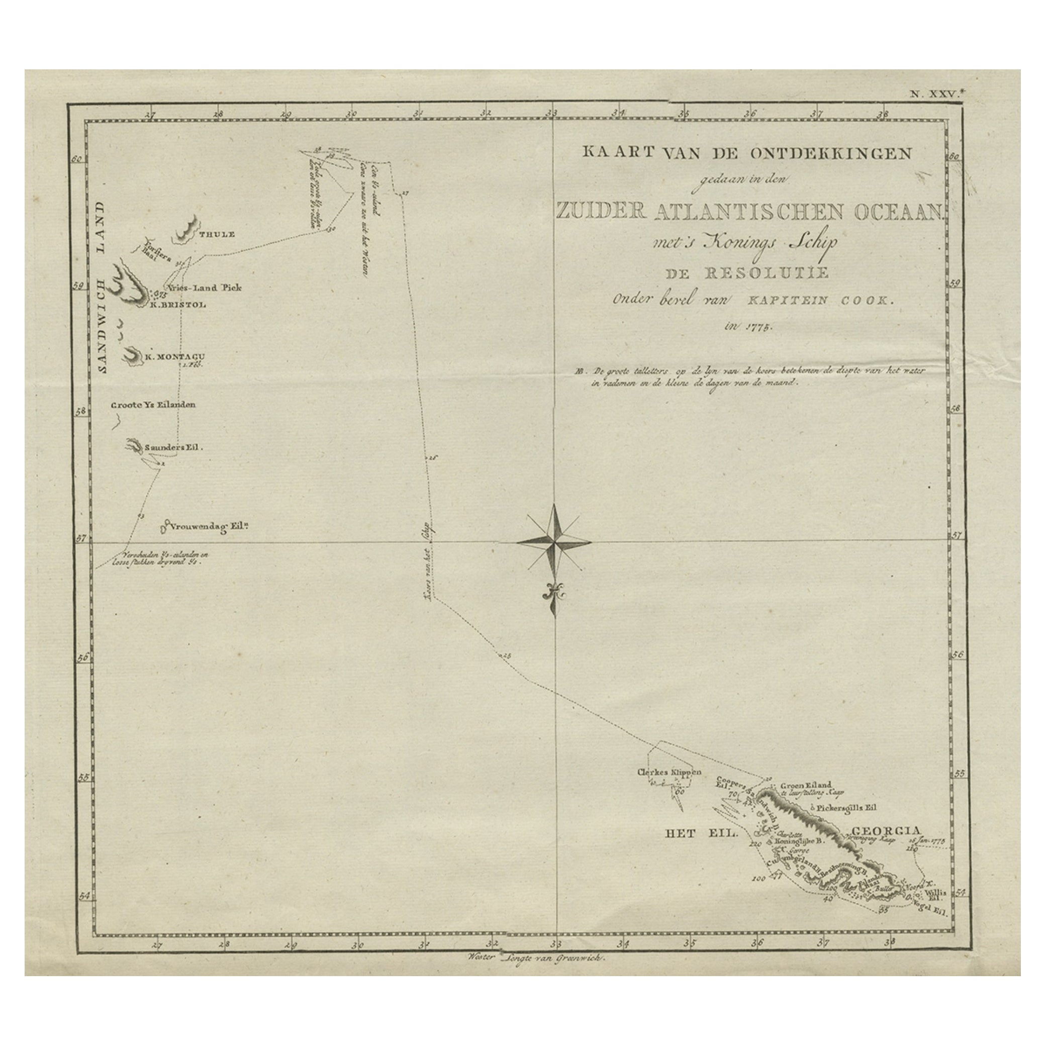
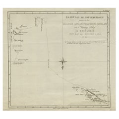
Old Antique of the Southern Georgia and the Sandwich Islands by Capt Cook, 1803
Located in Langweer, NL
Antique map Atlantic titled 'Kaart van de Ontdekkingen gedaan in den Zuider Atlantischen Oceaan (..)'.
Antique chart depicting Southern Georgia and the Sandwich Islands. Originat...
Category
Antique Early 1800s Maps
Materials
Paper
$594 Sale Price
20% Off
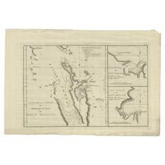
Detailed Map of New Zealand Showing the Route of Capt. Cook's First Voyage, 1803
Located in Langweer, NL
Antique map New Zealand titled 'De Rivier de Theems en Mercurius Baai in Nieuw Zeeland'. Detailed map of New Zealand showing the route of Capta...
Category
Antique 19th Century Maps
Materials
Paper
$528 Sale Price
30% Off
Antique Map of Suffren Island by Cook, 1803
Located in Langweer, NL
Antique map Australia titled 'Gezigt van het Eil. Suffren'. Antique map of Suffren Island. Originates from 'Reizen Rondom de Waereld door James C...
Category
Antique 19th Century Maps
Materials
Paper

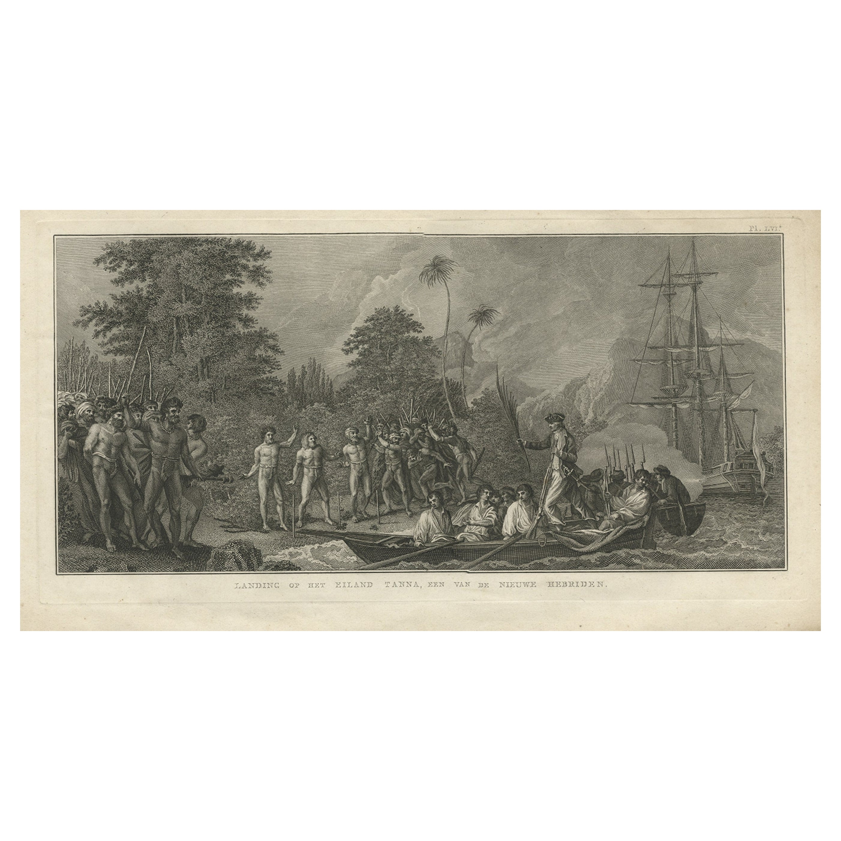
Antique Print of the Landing at Tanna Island by Cook, 1803
Located in Langweer, NL
Antique print New Hebrides titled 'Landing op het Eiland Tanna, een van de Nieuwe Hebriden'. Antique print depicting the landing at one of the islands of the New Hebrides, Vanuatu. O...
Category
Antique 19th Century Prints
Materials
Paper
You May Also Like
Captain Cook's Exploration of Tahiti 18th C. Hand-Colored Map by Bellin
By Jacques-Nicolas Bellin
Located in Alamo, CA
This beautiful 18th century hand-colored copper plate engraved map is entitled "Carte de l'Isle de Taiti, par le Lieutenant J. Cook" was created by Jacques Nicolas Bellin and publish...
Category
Antique Mid-18th Century French Maps
Materials
Paper

"Ships of War - Screw Gun Boat" lithograph by Day & Son, 1864
Located in London, GB
A Victorian framed print of "SHIPS OF WAR - Screw Gun Boat" by Day and Son, Lithographers to the Queen. Plate 84: The Modern System of Naval Architecture, Joh...
Category
Antique Mid-19th Century English Nautical Objects
Materials
Paper
Hand-Colored 18th Century Homann Map of Denmark and Islands in the Baltic Sea
By Johann Baptist Homann
Located in Alamo, CA
An 18th century copper plate hand-colored map entitled "Insulae Danicae in Mari Balthico Sitae utpote Zeelandia, Fionia, Langelandia, Lalandia, Falstria, Fembria Mona" created by Joh...
Category
Antique Early 18th Century German Maps
Materials
Paper

New Map of North America from the Latest Discoveries, 1763
Located in Philadelphia, PA
A fine antique 18th century map of the North American seaboard.
Entitled "A New Map of North America from the Latest Discoveries 1763".
By the Cartographer/Engraver - John Spil...
Category
Antique Mid-18th Century English Georgian Maps
Materials
Paper

19th Century Framed Engravings From The New Book Of Martyrs by Henry Southwell
Located in Lowestoft, GB
A collection of 11 framed and glazed engravings taken from the New Book Of Martyrs By Henry Southwell
The 11 engravings show authentic and genuine historical account of the many dre...
Category
Antique 19th Century English Religious Items
Materials
Glass, Pine, Paper
Map of the Republic of Genoa
Located in New York, NY
Framed antique hand-coloured map of the Republic of Genoa including the duchies of Mantua, Modena, and Parma.
Europe, late 18th century.
Dimension: 25...
Category
