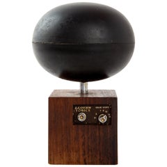
Lloyd's Yorick Rare Space Radio from Japan
View Similar Items


1 of 8
Lloyd's Yorick Rare Space Radio from Japan
About the Item
- Dimensions:Height: 7.88 in (20 cm)Width: 2.76 in (7 cm)Depth: 2.76 in (7 cm)
- Style:Mid-Century Modern (In the Style Of)
- Materials and Techniques:
- Place of Origin:
- Period:
- Date of Manufacture:Unknown
- Condition:Wear consistent with age and use. We did not test the radio for working. It is just an object. A sculpture.
- Seller Location:LA Arnhem, NL
- Reference Number:1stDibs: LU932913686551
Authenticity Guarantee
In the unlikely event there’s an issue with an item’s authenticity, contact us within 1 year for a full refund. DetailsMoney-Back Guarantee
If your item is not as described, is damaged in transit, or does not arrive, contact us within 7 days for a full refund. Details24-Hour Cancellation
You have a 24-hour grace period in which to reconsider your purchase, with no questions asked.Vetted Professional Sellers
Our world-class sellers must adhere to strict standards for service and quality, maintaining the integrity of our listings.Price-Match Guarantee
If you find that a seller listed the same item for a lower price elsewhere, we’ll match it.Trusted Global Delivery
Our best-in-class carrier network provides specialized shipping options worldwide, including custom delivery.You May Also Like
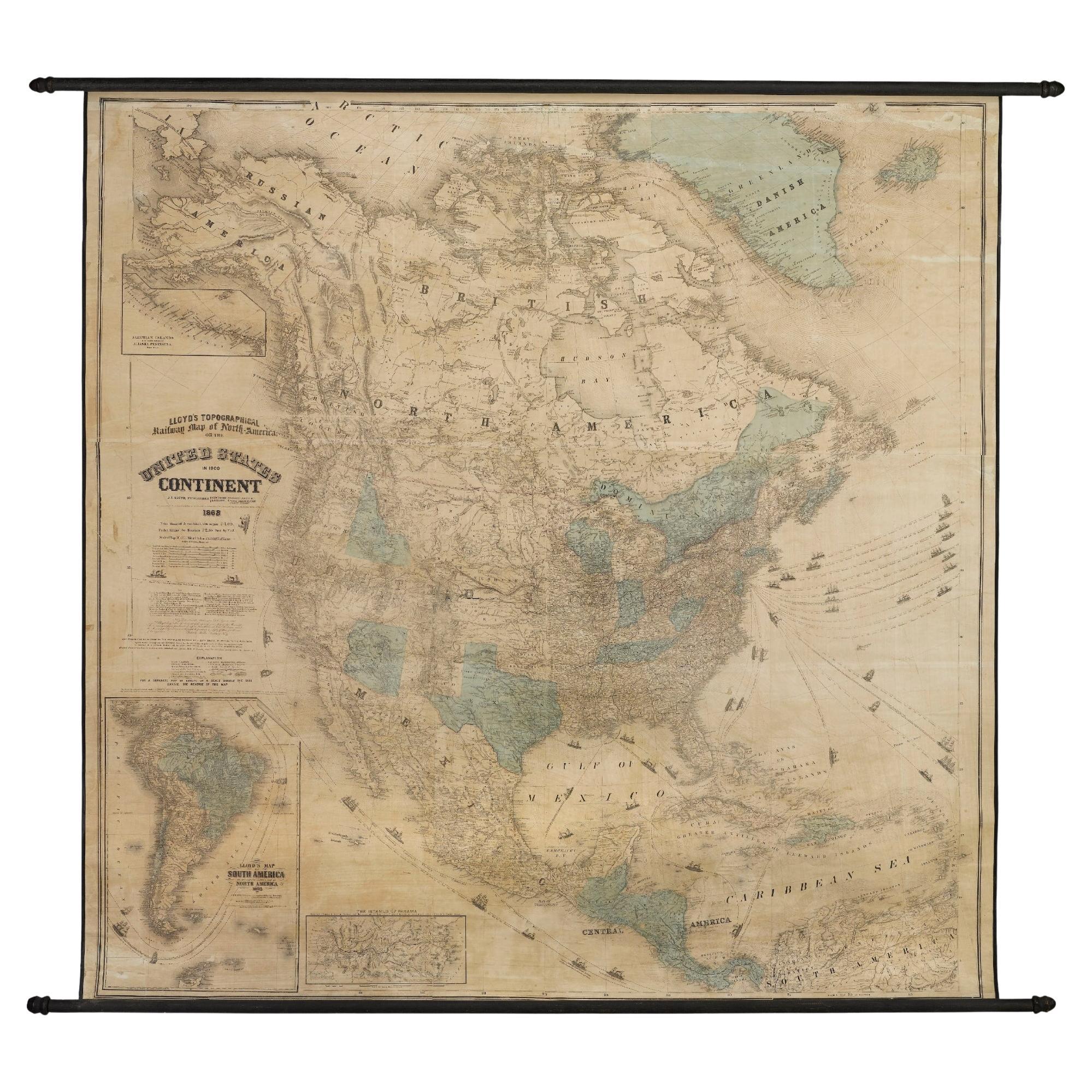
1868 "Lloyd's Topographical Railway Map of North America..." Hanging Wall Map
Located in Colorado Springs, CO
Presented is “Lloyd's Topographical Railway Map of North-America, or the United States Continent in 1900.” This map was published by J. T. Lloyd, in New York, in 1868. A large, hangi...
Category
Antique 1860s American Late Victorian Maps
Materials
Linen, Paper

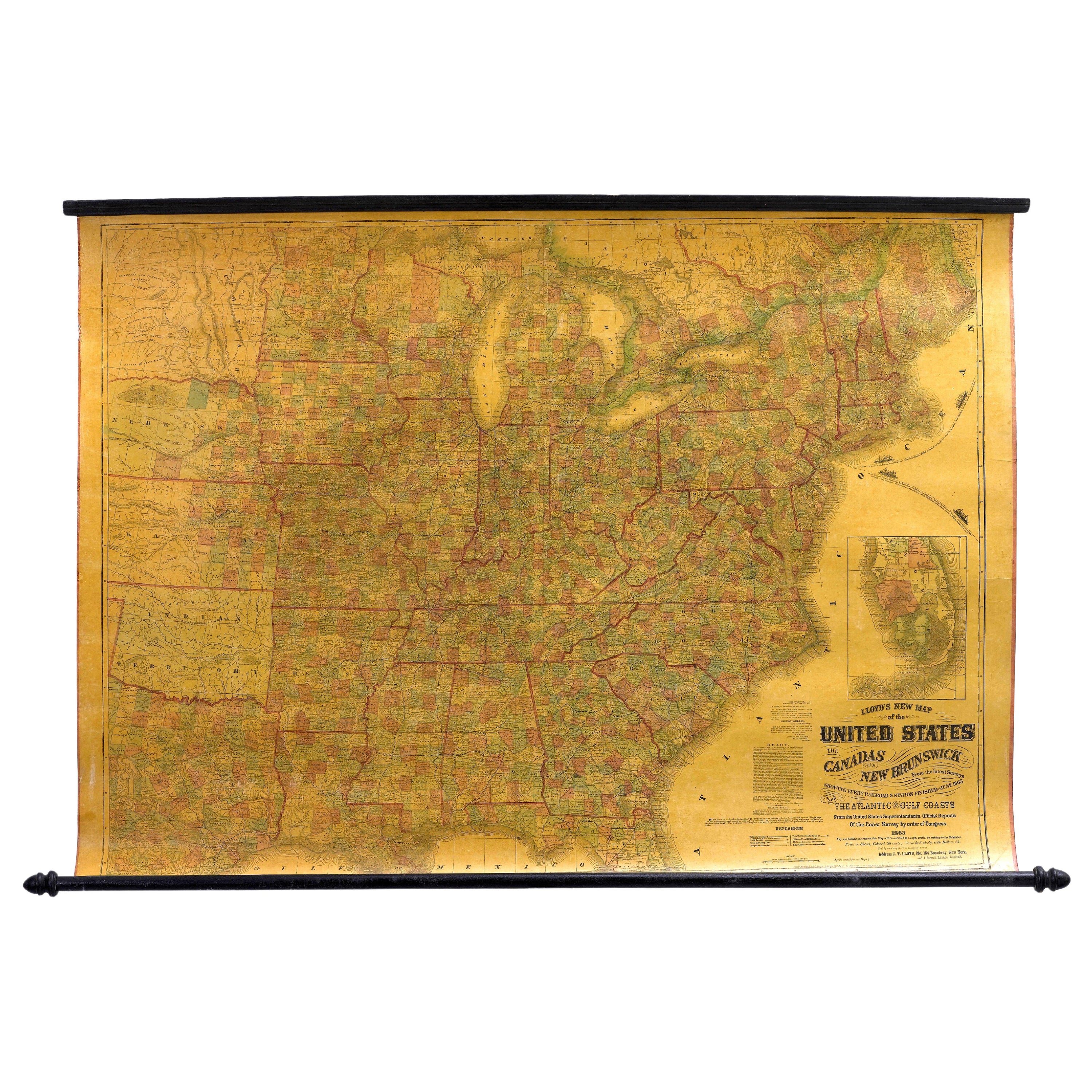
1863 "Lloyd's New Map of the United States, the Canadas, and New Brunswick"
Located in Colorado Springs, CO
Presented is “Lloyd's New Map of the United States, the Canadas and New Brunswick, From the latest Surveys, Showing Every Railroad & Station Finished to June 1863, and the Atlantic and Gulf Coasts.” A large, Civil War-era hanging map of the United States and adjacent territories, this map covers the area from the Atlantic Ocean and extends as far west as the 103 meridian, to “Dacotah,” Nebraska, Kansas, "Indian Territory," and Texas. The southern continuation of Florida is shown in an inset map along the right margin. This map was published by J. T. Lloyd, in New York, in 1863. According to the publisher’s marking at lower right, this map was originally issued in two states: "in Sheets, Colored" for 50 cents, and "Varnished nicely, with Rollers" for $1.
Throughout the map, the counties are colored and the towns and cities well labeled. A reference key in the bottom margin provides symbols for railroads, turnpikes and wagon roads, state capitals, cities and towns, and village post offices. As emphasized in the map’s title, this map is especially notable for the countless railway lines and stations depicted, with distances noted between points, listing “every railroad and finished station to June 1863.” Additionally, two shipping agents and their routes are drawn out of New York City. The map includes details of the steamship routes into New York and Philadelphia from Liverpool and on to California and Oregon via an overland Nicaraguan trek, presumably to assist gold rush emigrants.
This expansive and impressive map depicts the eastern half of the United States in the third year of the Civil War. In order not to recognize the legitimacy of the Confederate States of America, each state is shown in the same manner as the Union states. The only indication that the American Civil War was in progress when this map was published is a printed notice that Gideon Wells, Secretary of the Navy, wishes to acquire a quote on 100 copies of Lloyd’s Mississippi River map...
Category
Antique 1860s American Maps
Materials
Linen, Wood, Paper

Vintage Toot-a-loop Radio by Panasonic, Japan, 1970s
Located in Mexico City, CDMX
Vintage Toot-a-Loop radio (model nr: Panasonic R-72): an emblematic radio, designed and fabricated by Panasonic Japan in the early 1970s. The radio was designed to be wrapped and car...
Category
Vintage 1970s Japanese Other Musical Instruments
Materials
Plastic

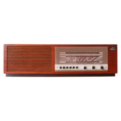
Teak Type 135 Radio from Wega, 1960s
By Wega
Located in Lisboa, PT
This radio, type 135, was made by Wega in West-Germany, during the 1960's. With a teak wooden case, it has broadcast, long wave, short wave plus FM or UHF. ...
Category
Vintage 1960s German Mid-Century Modern Musical Instruments
Materials
Teak
$457 Sale Price
20% Off
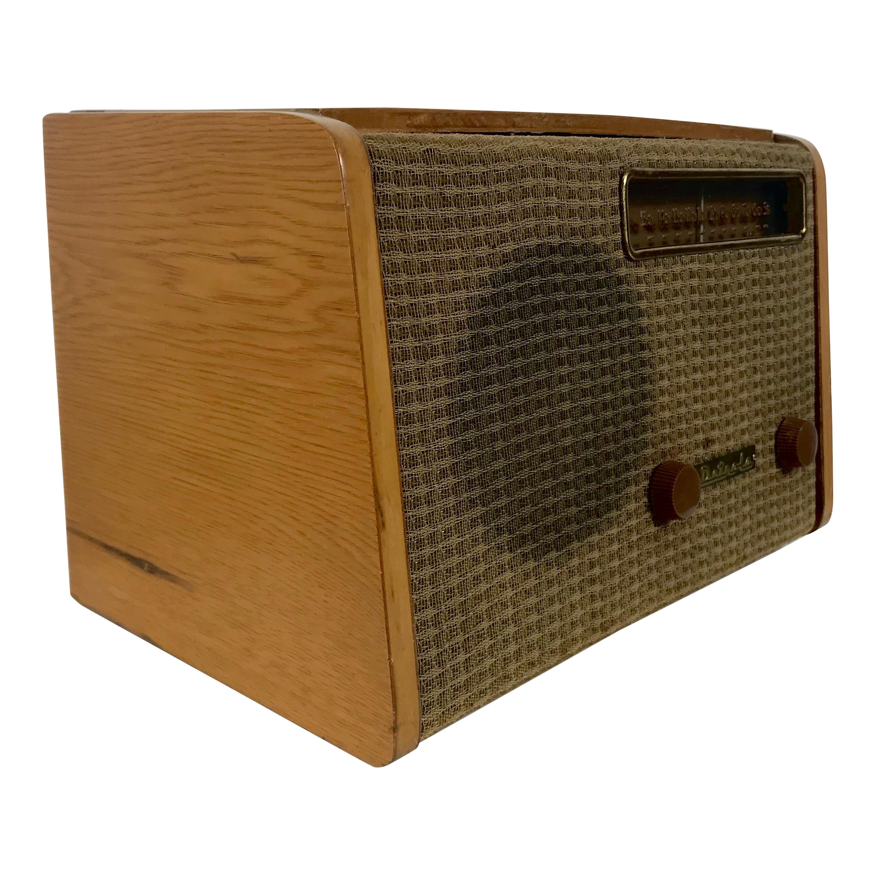
Rare Alexander Girard Detrola Radio, circa 1946, Modernist
By Alexander Girard
Located in Buffalo, NY
Nice original working condition,, replaced back..
Signed with stamped manufacturer’s mark to underside: [12132].
USA
Medium
Design/Decorative Art
Manufacturer
Detrola Radio...
Category
Vintage 1940s American Mid-Century Modern Musical Instruments
Materials
Brass

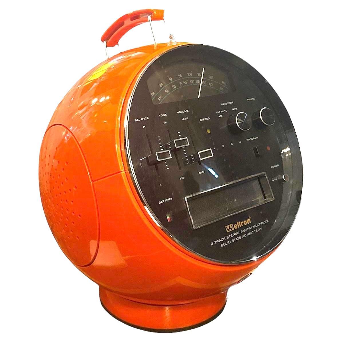
Weltron Mod.2004 Space Ball stereo Radio/Tape - 1970s
Located in Linkebeek, BE
Space Age design - Radio LW/MW/FM
Transport yourself back to the groovy 1970s with the vintage 1970s White Weltron radio and iconic Space Age Ball 8-trac...
Category
Mid-20th Century American Musical Instruments
Materials
Plastic

Recently Viewed
View AllMore Ways To Browse
Vintage Lloyds Radio
Vintage Lloyds Speakers
Baby Piano
Steinway And Sons
Vintage 1960 Record Player
Mobile File
Vintage Record Player Radio
Vintage Record Players
Brionvega Radio
Military Drum
Steinway And Sons Piano
Rosewood Piano
Old Record Players Record Players
19th Century Grand Piano
Antique Music Player
French Grand Piano
Record Player Radio
Restoring Vintage Radios