Items Similar to Vintage Road Map of the Netherlands '1928'


Want more images or videos?
Request additional images or videos from the seller
1 of 6
Vintage Road Map of the Netherlands '1928'
About the Item
Vintage map titled 'Volgens het vijfjarig Werkplan te verbeteren Rijkswegen en nieuw aan te leggen wegen welke voorkomen op het Rijkswegenplan'. Map of the Netherlands, used to illustrate the highways/roads that need improvement or that need to be build. Published 1928.
- Dimensions:Height: 22.01 in (55.9 cm)Width: 25.6 in (65 cm)Depth: 0.02 in (0.5 mm)
- Materials and Techniques:
- Period:
- Date of Manufacture:1928
- Condition:General age-related toning, original folding lines. Some wear, blank verso. Please study image carefully.
- Seller Location:Langweer, NL
- Reference Number:Seller: BG-00641stDibs: LU3054324502362
About the Seller
5.0
Recognized Seller
These prestigious sellers are industry leaders and represent the highest echelon for item quality and design.
Platinum Seller
Premium sellers with a 4.7+ rating and 24-hour response times
Established in 2009
1stDibs seller since 2017
2,412 sales on 1stDibs
Typical response time: 1 hour
- ShippingRetrieving quote...Shipping from: Langweer, Netherlands
- Return Policy
Authenticity Guarantee
In the unlikely event there’s an issue with an item’s authenticity, contact us within 1 year for a full refund. DetailsMoney-Back Guarantee
If your item is not as described, is damaged in transit, or does not arrive, contact us within 7 days for a full refund. Details24-Hour Cancellation
You have a 24-hour grace period in which to reconsider your purchase, with no questions asked.Vetted Professional Sellers
Our world-class sellers must adhere to strict standards for service and quality, maintaining the integrity of our listings.Price-Match Guarantee
If you find that a seller listed the same item for a lower price elsewhere, we’ll match it.Trusted Global Delivery
Our best-in-class carrier network provides specialized shipping options worldwide, including custom delivery.More From This Seller
View AllAntique Map of the Province of Overijssel, the Netherlands
Located in Langweer, NL
Original antique map titled 'Ditio Trans-Isulana'. Original old map of the province of Overijssel, the Netherlands. With coat of arms and two decorative cartouches. Published by J. J...
Category
Antique Mid-17th Century Maps
Materials
Paper

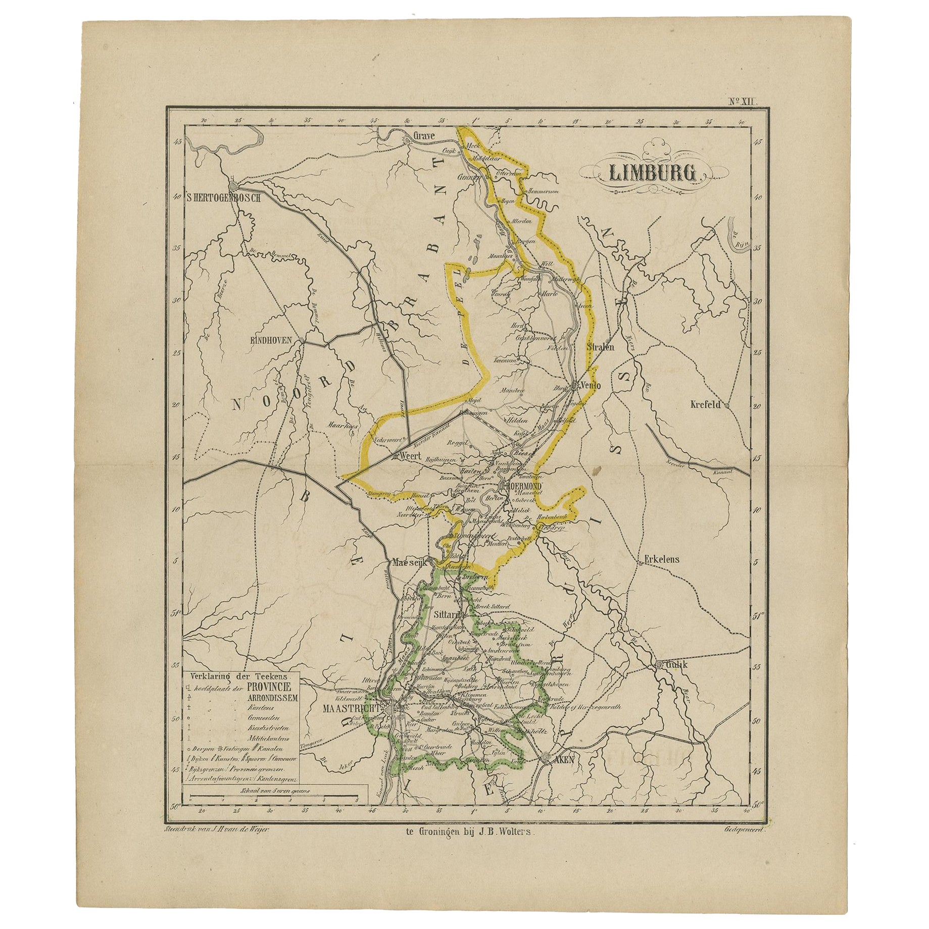
Antique Map of the Province Limburg, The Netherlands, 1864
Located in Langweer, NL
Antique map titled 'De Provincie Limburg'. Map of the province of Limburg, the Netherlands. This map originates from 'F. C. Brugsma's Atlas van het Koninkrijk der Nederlanden (..)'. ...
Category
Antique 19th Century Maps
Materials
Paper
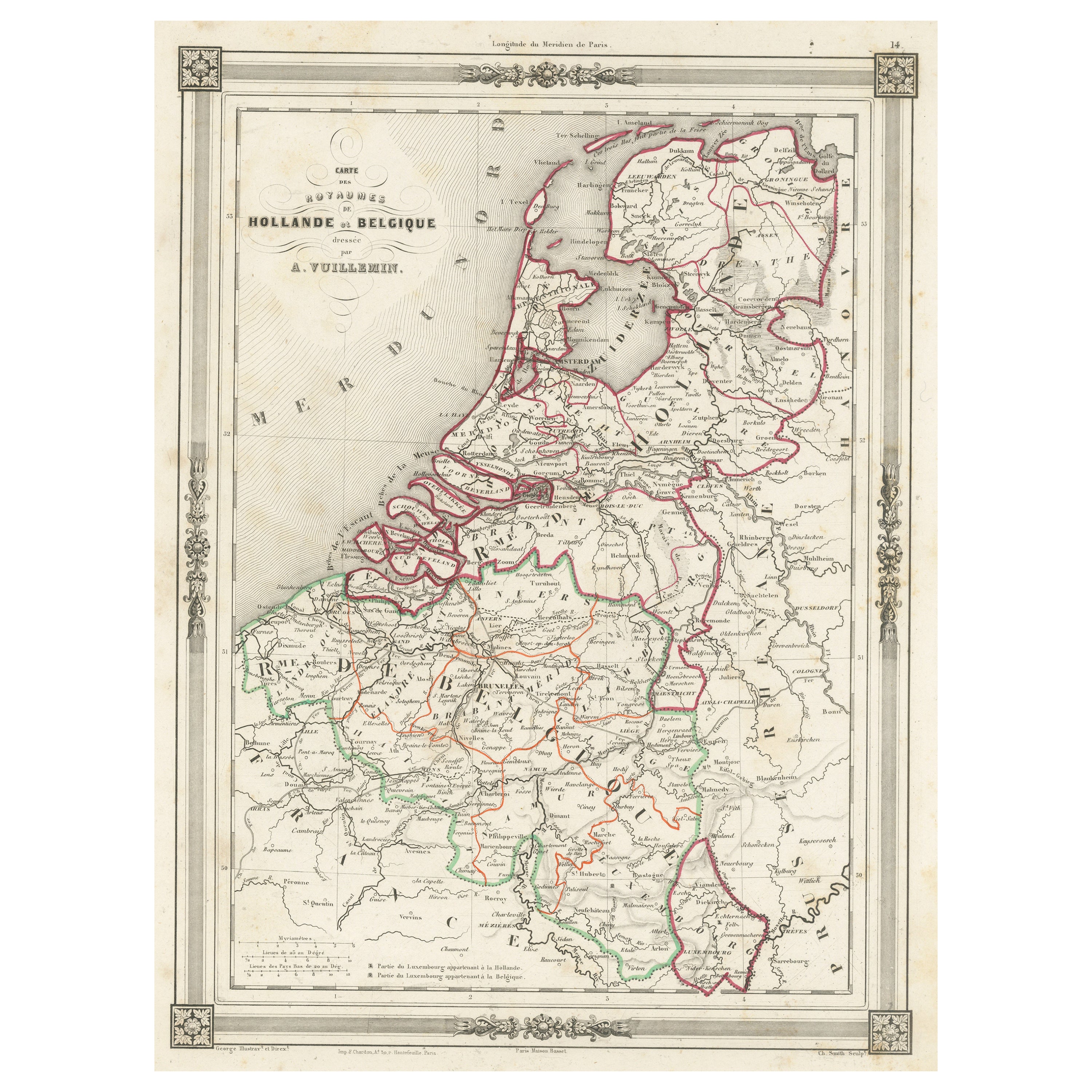
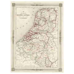
Antique Map of the Netherlands, Belgium and Luxembourg
Located in Langweer, NL
Antique map titled 'Carte des Royaumes Hollande et Belgique'. Attractive map of the Netherlands, Belgium and Luxembourg. This map originates fro...
Category
Antique Mid-19th Century Maps
Materials
Paper
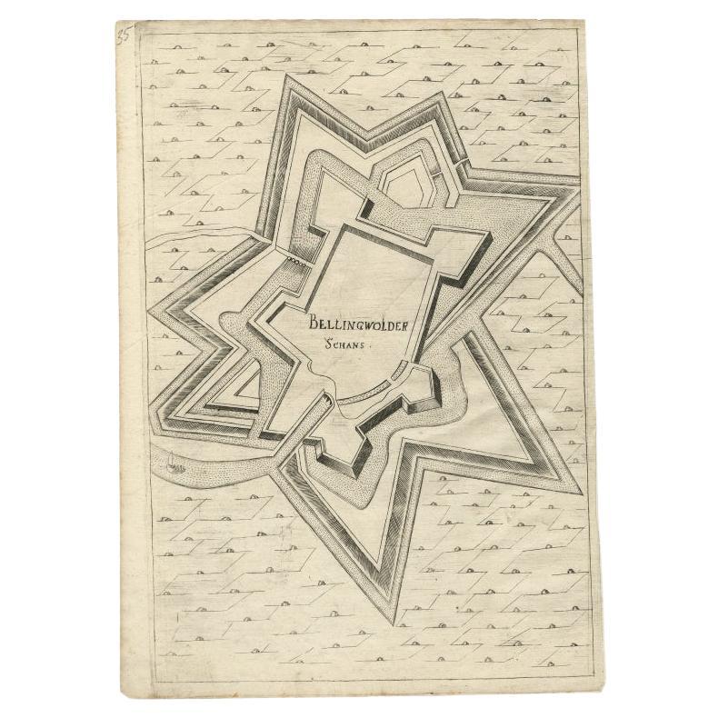
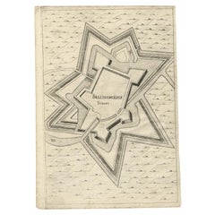
Antique Map of Fortification of Bellingwolderschans, The Netherlands, 1673
Located in Langweer, NL
Antique map titled 'Bellingwolderschans'. Original map of the fortification of Bellingwolderschans, the Netherlands. This map originates from 'Teatro del Belgio', by G. Gualdo Priora...
Category
Antique 17th Century Maps
Materials
Paper
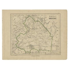
Antique Map of Drenthe, Province of the Netherlands, C.1870
Located in Langweer, NL
Antique map titled 'De Provincie Drenthe'. Map of the province of Drenthe, the Netherlands. This map originates from 'F. C. Brugsma's Atlas van het Koninkrijk der Nederlanden (..)'. ...
Category
Antique 19th Century Maps
Materials
Paper
Antique Map of the Kingdom of the Netherlands by Wyld '1845'
Located in Langweer, NL
Antique map titled 'Holland & Belgium formerly Kingdom of the Netherlands'. Original antique map of the Kingdom of the Netherlands. This map originates from 'An Atlas of the World, C...
Category
Antique Mid-19th Century Maps
Materials
Paper

You May Also Like
Map of the Republic of Genoa
Located in New York, NY
Framed antique hand-coloured map of the Republic of Genoa including the duchies of Mantua, Modena, and Parma.
Europe, late 18th century.
Dimension: 25...
Category
Antique Late 18th Century European Maps

Vintage "View of the Center of Paris Taken from the Air" Lithograph Map
Located in San Diego, CA
A very stylish "View of the Center of Paris Taken from the Air" lithograph map published by the Paris Ministry of Tourism, circa early 1950s. The piece measures 27" x 43" and shows...
Category
20th Century French Mid-Century Modern Prints
Materials
Paper

$680 Sale Price
20% Off
Map "Estuary- Mouth of the Thames"
Located in Alessandria, Piemonte
ST/426 - Antique French Map of the estuary of the Thames, map dated 1769 -
"Mape of the entrance of the Thames. Designed by filing of Navy cards fo...
Category
Antique Mid-18th Century French Other Prints
Materials
Paper

New Map of North America from the Latest Discoveries, 1763
Located in Philadelphia, PA
A fine antique 18th century map of the North American seaboard.
Entitled "A New Map of North America from the Latest Discoveries 1763".
By the Cartographer/Engraver - John Spil...
Category
Antique Mid-18th Century English Georgian Maps
Materials
Paper

Antique 18th Century Map of the Province of Pensilvania 'Pennsylvania State'
Located in Philadelphia, PA
A fine antique of the colony of Pennsylvania.
Noted at the top of the sheet as a 'Map of the province of Pensilvania'.
This undated and anonymous map is thought to be from the Gentleman's Magazine, London, circa 1775, although the general appearance could date it to the 1760's.
The southern boundary reflects the Mason-Dixon survey (1768), the western boundary is placed just west of Pittsburgh, and the northern boundary is not marked.
The map has a number of reference points that likely refer to companion text and appear to be connected to boundaries. The western and southern boundaries are marked Q, R, S, for example. A diagonal line runs from the Susquehanna R to the Lake Erie P. A broken line marked by many letters A, B, N, O, etc., appears in the east.
There are no latitude or longitude markings, blank verso.
Framed in a shaped contemporary gilt wooden frame and matted under a cream colored matte.
Bearing an old Graham Arader Gallery...
Category
Antique 18th Century British American Colonial Maps
Materials
Paper

Original Antique Map of The World by Thomas Clerk, 1817
Located in St Annes, Lancashire
Great map of The Eastern and Western Hemispheres
On 2 sheets
Copper-plate engraving
Drawn and engraved by Thomas Clerk, Edinburgh.
Published by Mackenzie And Dent, 1817
...
Category
Antique 1810s English Maps
Materials
Paper

Recently Viewed
View AllMore Ways To Browse
Map Ukraine
Scan Globe
Serbia Antique Map
Shetland Map
Cham Antiques
Civil War Virginia Map
Map Of Cumberland
Map Of Virginia Civil War
Antique Furniture Trinidad
Antique Kiel Furniture
Antique Map Of Brooklyn
Antique Maps Of Maryland
Cham Kingdom
Gloucestershire Antique Map
Map Gloucestershire
Map Of Ibiza
Map Of Native American Tribes
Mongolia Maps