Items Similar to Saint-Domingue (French Section): 18th Century Map from France Militaire Series

Want more images or videos?
Request additional images or videos from the seller
1 of 7
Saint-Domingue (French Section): 18th Century Map from France Militaire Series
About the Item
This map is titled "St. Domingue (Partie Française)" and is part of the France Militaire series. It focuses on the French portion of Saint-Domingue, which corresponds to modern-day Haiti.
Features:
- The map provides a detailed view of the French colonial territory in Saint-Domingue, the western part of the island of Hispaniola, known for being one of France’s most profitable colonies during the 18th century due to its sugar and coffee plantations.
- Key cities and regions are marked, including Port-au-Prince, Cap Français (now Cap-Haïtien), and the Île de la Gonâve.
- The geographical features are represented with great detail, including mountain ranges, rivers, and coastal regions. Important bays such as the Baie de Port-au-Prince are also labeled.
- To the left, the map includes part of Cuba, highlighting how close the island is to Saint-Domingue.
Historical Context:
- The map likely dates to the late 18th century or early 19th century, around the time of the Haitian Revolution (1791–1804), which led to the independence of Haiti from France.
- The title "France Militaire" suggests that this map may have been used for military purposes, possibly related to French colonial administration or military campaigns during the turbulent period of the Haitian Revolution.
Artistic and Cartographic Details:
- The map is finely engraved, with detailed line work showcasing both natural and urban features.
- It was drawn by Monin and engraved by Jacqueline and Barrière, well-known cartographers and engravers of the time.
The map of **Saint-Domingue (Partie Française)** from the **France Militaire** series likely dates to the **late 18th century or early 19th century**, specifically around **1790 to 1804**.
This period corresponds with significant historical events, including the Haitian Revolution (1791-1804), during which Haiti (formerly the French colony of Saint-Domingue) gained its independence from France. The title "France Militaire" suggests that the map was created for military or administrative purposes, possibly in relation to French efforts to maintain control over the colony during the revolution.
Given these factors, the map most likely dates between 1790 and 1800, during the last years of French control over Saint-Domingue.
- Dimensions:Height: 7.17 in (18.2 cm)Width: 10.83 in (27.5 cm)Depth: 0 in (0.02 mm)
- Materials and Techniques:
- Period:1790-1799
- Date of Manufacture:circa 1790
- Condition:Condition: good, given age. General age-related toning and/or occasional minor defects from handling. Please study scan carefully.
- Seller Location:Langweer, NL
- Reference Number:Seller: BG-13093-251stDibs: LU3054341482282
About the Seller
5.0
Recognized Seller
These prestigious sellers are industry leaders and represent the highest echelon for item quality and design.
Platinum Seller
Premium sellers with a 4.7+ rating and 24-hour response times
Established in 2009
1stDibs seller since 2017
2,415 sales on 1stDibs
Typical response time: 1 hour
- ShippingRetrieving quote...Shipping from: Langweer, Netherlands
- Return Policy
Authenticity Guarantee
In the unlikely event there’s an issue with an item’s authenticity, contact us within 1 year for a full refund. DetailsMoney-Back Guarantee
If your item is not as described, is damaged in transit, or does not arrive, contact us within 7 days for a full refund. Details24-Hour Cancellation
You have a 24-hour grace period in which to reconsider your purchase, with no questions asked.Vetted Professional Sellers
Our world-class sellers must adhere to strict standards for service and quality, maintaining the integrity of our listings.Price-Match Guarantee
If you find that a seller listed the same item for a lower price elsewhere, we’ll match it.Trusted Global Delivery
Our best-in-class carrier network provides specialized shipping options worldwide, including custom delivery.More From This Seller
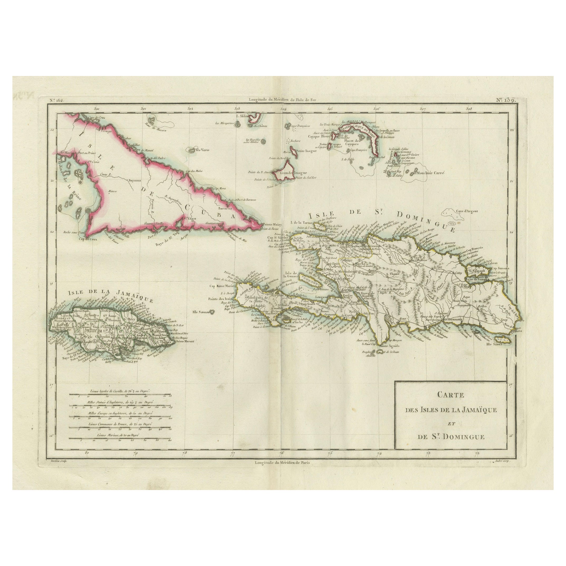
View AllAntique Map of Jamaica and Hispaniola (Saint-Domingue and Santo Domingo), 1802
Located in Langweer, NL
This is an original antique map titled "Carte des Isles de la Jamaïque et de St. Domingue," depicting the islands of Jamaica and Saint-Domingue (modern-day Haiti and the Dominican Re...
Category
Antique Early 1800s Maps
Materials
Paper
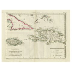
$517 Sale Price
20% Off
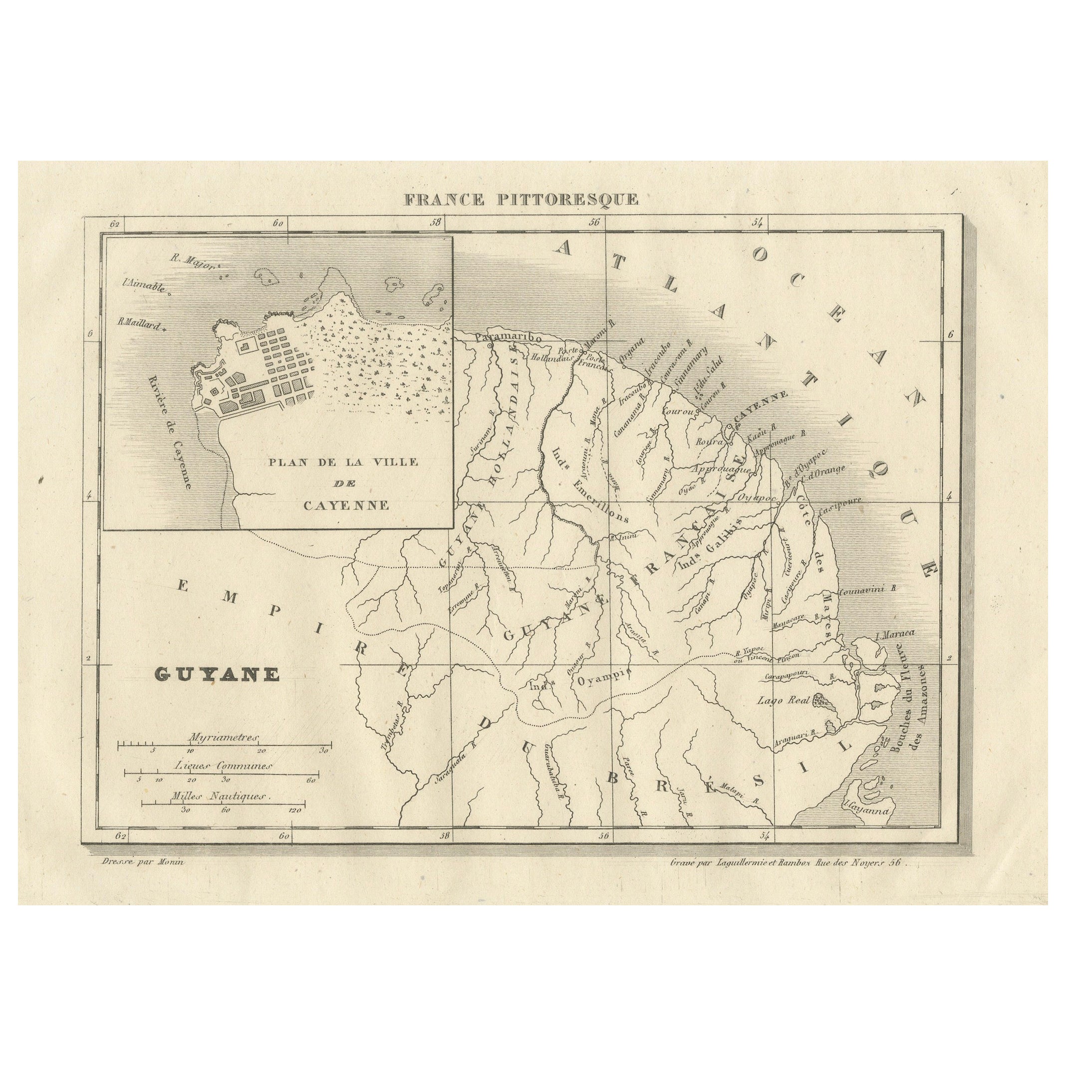
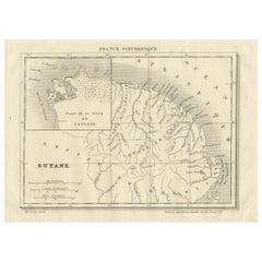
French Guiana and Cayenne: Mid-19th Century Map from France Pittoresque Series
Located in Langweer, NL
This map titled "Guyane" is part of the France Pittoresque series and provides a detailed view of French Guiana along with a plan of the city of Cayenne.
Features:
- The map showcases the broader region of French Guiana, indicating key rivers, settlements, and the coastline along the Atlantic Ocean.
- To the left, there's an inset labeled "Plan de la Ville de Cayenne", which shows the street layout, squares, and main buildings of the capital city, Cayenne. This inset provides a more detailed view of the urban area, highlighting its geometric grid layout near the coast.
- The larger map outlines geographical features such as rivers (e.g., Oyapock and Maroni), forests, and territories in the surrounding area, including the neighboring Brazilian Empire...
Category
Antique 1850s Maps
Materials
Paper
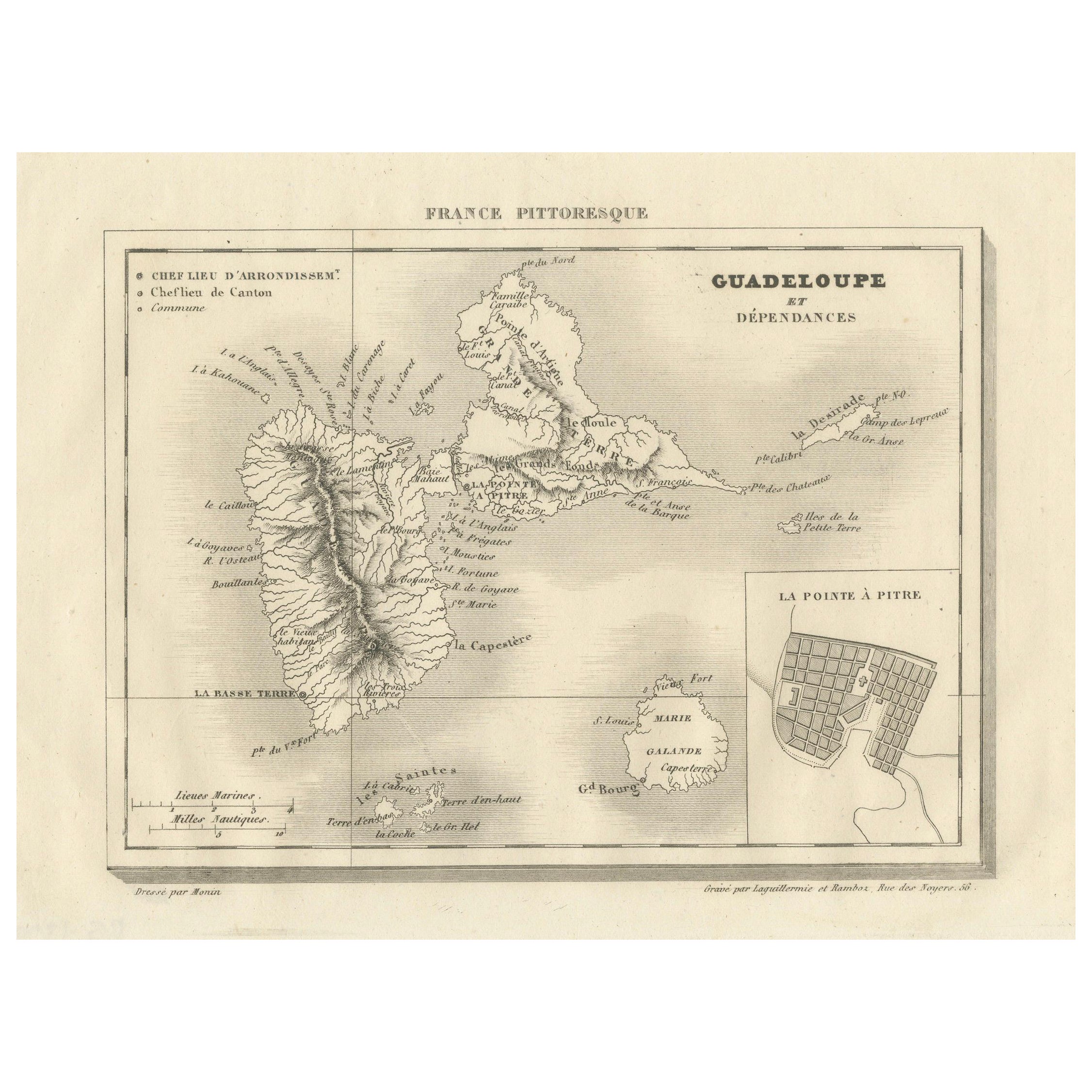
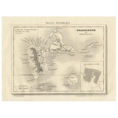
Guadeloupe and Dependencies: Mid-19th Century Map from France Pittoresque Series
Located in Langweer, NL
This map titled "Guadeloupe et Dépendances" is part of the France Pittoresque series and provides a detailed view of the island of Guadeloupe and its surrounding dependencies.
Features:
- The map shows the two main landmasses of Guadeloupe: Basse-Terre and Grande-Terre, separated by a narrow channel.
- Several smaller islands, including Marie-Galante, Les Saintes, and La Désirade, are also depicted.
- The main cities, towns, and geographical features are labeled, with emphasis on the island's mountain ranges and rivers, particularly on Basse-Terre.
- An inset at the bottom right provides a detailed plan of Pointe-à-Pitre, a major city and port on the island. The grid layout of the streets is clearly shown, reflecting urban planning of the time.
Artistic and Cartographic Details:
- The map uses clear linework to differentiate between the different islands and the sea, with significant natural features such as mountains and rivers carefully depicted.
- The map was drawn by Monin and engraved by Jacqueline and Barrière, whose names appear in the lower right corner.
- The scale in the lower left corner is measured in leagues, showing distances both by land and sea.
Historical Context:
- This map likely dates to the mid-19th century, a period when Guadeloupe was a key French colony in the Caribbean. Guadeloupe was known for its sugar and coffee plantations, which played a significant role in France's colonial economy.
- Maps like this were often used for administrative, military, and educational purposes to give a comprehensive view of France's overseas territories.
The map of Guadeloupe et Dépendances from the France Pittoresque series likely dates to the mid-19th century, around 1840 to 1860. This period corresponds to the height of French colonial influence in Guadeloupe, and the map's style, detailed urban planning, and cartographic techniques are consistent with maps produced in that era.
The specific publication date could be further narrowed down if the map was part of a known edition of the France Pittoresque atlas, but based on the cartographic style and historical context, 1840–1860 is a reasonable estimate.
Here are some relevant keywords people might use when searching for a map of Guadeloupe and its surrounding areas:
1. Guadeloupe map
2. Basse-Terre and Grande-Terre map
3. French Caribbean islands map...
Category
Antique 1850s Maps
Materials
Paper
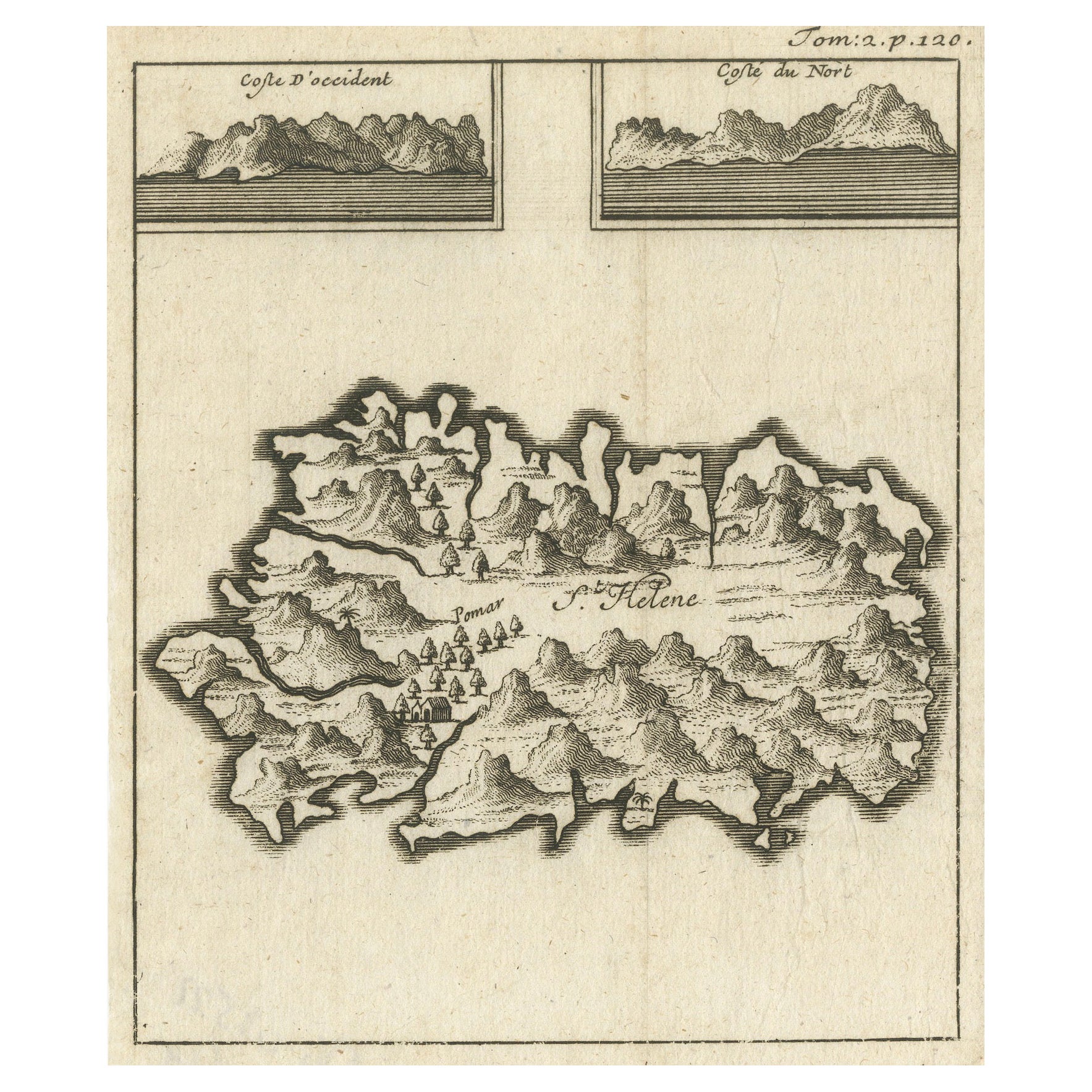
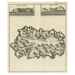
Map of Saint Helena Island: Early 18th-Century Copper Engraving by F. Bernard
Located in Langweer, NL
Map of Saint Helena Island: Early 18th-Century Copper Engraving by F. Bernard
This rare and beautifully detailed copper engraving of Saint Helena Island dates from around 1722 and...
Category
Antique 1720s Maps
Materials
Paper
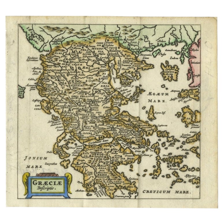
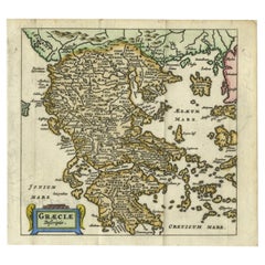
Charming 18th Century Miniature Map of Greece, 1685
Located in Langweer, NL
Antique map titled 'Graeciae Descriptio.' Charming miniature map of Greece from the pocket atlas 'Introductionis in Universam Geographiam tam Veterem qu...
Category
Antique 17th Century Maps
Materials
Paper
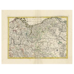
A Detailed Mid-18th Century German Map of North-Central Europe
Located in Langweer, NL
This is an antique, hand-colored engraved map of north-central Europe (centered on the region of Brandenburg, Pomerania, and portions of what is now northern Poland) that was produce...
Category
Antique 1730s Maps
Materials
Paper
You May Also Like
Rare 18th C. Newport Map
Located in Sandwich, MA
Rare 18th C, Map titled "A plan of the town of Newport in the province of Rhode Island". Earliest printed plan of Newport, published for the use of the British just prior to their o...
Category
Antique 1770s American Maps
Materials
Paper

$19,500 / item
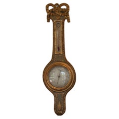
French 18th Century Barometer
Located in Charlottesville, VA
A non working French barometer . Beautiful paint and gilding.
Category
Antique 18th Century French Scientific Instruments
Materials
Metal
18th Century French Reliquaries
Located in Dallas, TX
Set of three 18th century French Reliquaries.
Carved wood with metal repousse over the wood
Each piece contains the original Latin pages framed in o...
Category
Antique Early 18th Century French French Provincial Religious Items
Materials
Metal

$6,720 / set
French 18th Century Glove
Located in Atlanta, GA
A very intriguing 18th century glove in wood and leather with iron protrusions. One's hand is inserted into the glove with positions for all fingers - like a baseball glove. The orig...
Category
Antique Mid-18th Century French Arms, Armor and Weapons
Materials
Iron
“Saint Dominic and Saint Francis”, Colonial School, 18th Century
Located in Madrid, ES
“Saint Dominic and Saint Francis”. Polychromed terracotta. Colonial (South America) school, 18th century.
It is narrated in this piece, with a remarkable...
Category
Antique 18th Century South American Baroque Religious Items
Materials
Terracotta

18th Century Carved And Painted Wooden Crucifix From France
Located in Haddonfield, NJ
An early 18th Century antique hand carved and polychromed hand painted table crucifix from France with its original patina preserved.
This crucifix could possible date back as early ...
Category
Antique Early 18th Century French Baroque Sculptures and Carvings
Materials
Fruitwood

$920 Sale Price
20% Off
Recently Viewed
View AllMore Ways To Browse
Western Sugar
Pair Antique Footstools
Pair Of Italian Chrome Lounge Chairs
Pair Of Leather Accent Chairs
Paisley Throws
Palm Sterling
Pedestal Inlaid Wood Tables
Pillow Arm Sofa
Pouf Metal Base
Rattan Sun Lounge
Raw Wooden Table
Red Baccarat
Red Chair And Ottoman
Round Bar Carts
Round Onyx Table
Rustic Leather Dining Chair
Scandinavian Bentwood Chairs
Scroll Feet Coffee Table