Items Similar to Political Map of Europe: Early 19th Century, from the 1802 Tardieu Atlas
Want more images or videos?
Request additional images or videos from the seller
1 of 6
Political Map of Europe: Early 19th Century, from the 1802 Tardieu Atlas
About the Item
Antique Map Description
Title: Carte Générale et Politique de l'Europe
Publication Details:
- **Atlas Title:** Nouvel Atlas Universel de Géographie Ancienne et Moderne
- **Purpose:** For the Nouvelle Edition de la Géographie de Guthrie
- **Mapmakers:** P. F. Tardieu, with contributions from various geographical works
- **Publisher:** Chez Hyacinthe Langlois, Libraire, quai des Augustins, n° 45
- **Year:** An X - 1802 (French Revolutionary Calendar)
**Geographical Scope:**
This antique map illustrates the general and political landscape of Europe as understood in the early 19th century. It captures the various countries, regions, and major political boundaries of the time.
**Map Features:**
- **Regions Displayed:** Entire European continent, including parts of Western Russia, the British Isles, Scandinavia, and the Mediterranean regions.
- **Notable Regions and Territories:** France, Spain, Portugal, Italy, Germany, Scandinavia, Eastern Europe, the British Isles, and parts of the Ottoman Empire (Anatolia).
- **Seas and Bodies of Water:** Atlantic Ocean, North Sea, Baltic Sea, Mediterranean Sea, Black Sea.
- **Political Boundaries:** Marked with colored lines to differentiate between countries and regions.
- **Topographical Details:** Includes mountain ranges, rivers, and other significant geographical features as understood in the early 19th century.
- **Cartographic Style:** Detailed engraving with hand-colored boundaries, emphasizing both historical accuracy and artistic presentation.
**Purpose and Use:**
This map serves as a comprehensive visual representation of Europe's political landscape, reflecting the geographical understanding and cartographic style of the early 19th century. It was part of a larger atlas that included 60 maps, providing a detailed view of both ancient and modern geography as known in 1802.
Condition Report
The map is in good condition with minor age-related wear. Hand-colored boundaries are well-preserved, enhancing the clarity of regions and features. Slight fold lines and edge wear are visible, with some age spots.
Coloring
The hand-colored boundaries on the map highlight regions and territories, adding clarity and visual appeal, typical of early 19th-century cartographic practices.
- Dimensions:Height: 16.3 in (41.4 cm)Width: 22.41 in (56.9 cm)Depth: 0.01 in (0.2 mm)
- Materials and Techniques:Paper,Engraved
- Period:
- Date of Manufacture:1802
- Condition:Good condition with minor age-related wear. Hand-colored boundaries are well-preserved, enhancing the clarity of regions and features. Fold lines and edge wear are visible, with some age spots, mostly in border. Study the scans carefully.
- Seller Location:Langweer, NL
- Reference Number:Seller: BG-13769-61stDibs: LU3054340557372
About the Seller
5.0
Recognized Seller
These prestigious sellers are industry leaders and represent the highest echelon for item quality and design.
Platinum Seller
Premium sellers with a 4.7+ rating and 24-hour response times
Established in 2009
1stDibs seller since 2017
2,415 sales on 1stDibs
Typical response time: 1 hour
- ShippingRetrieving quote...Shipping from: Langweer, Netherlands
- Return Policy
Authenticity Guarantee
In the unlikely event there’s an issue with an item’s authenticity, contact us within 1 year for a full refund. DetailsMoney-Back Guarantee
If your item is not as described, is damaged in transit, or does not arrive, contact us within 7 days for a full refund. Details24-Hour Cancellation
You have a 24-hour grace period in which to reconsider your purchase, with no questions asked.Vetted Professional Sellers
Our world-class sellers must adhere to strict standards for service and quality, maintaining the integrity of our listings.Price-Match Guarantee
If you find that a seller listed the same item for a lower price elsewhere, we’ll match it.Trusted Global Delivery
Our best-in-class carrier network provides specialized shipping options worldwide, including custom delivery.More From This Seller
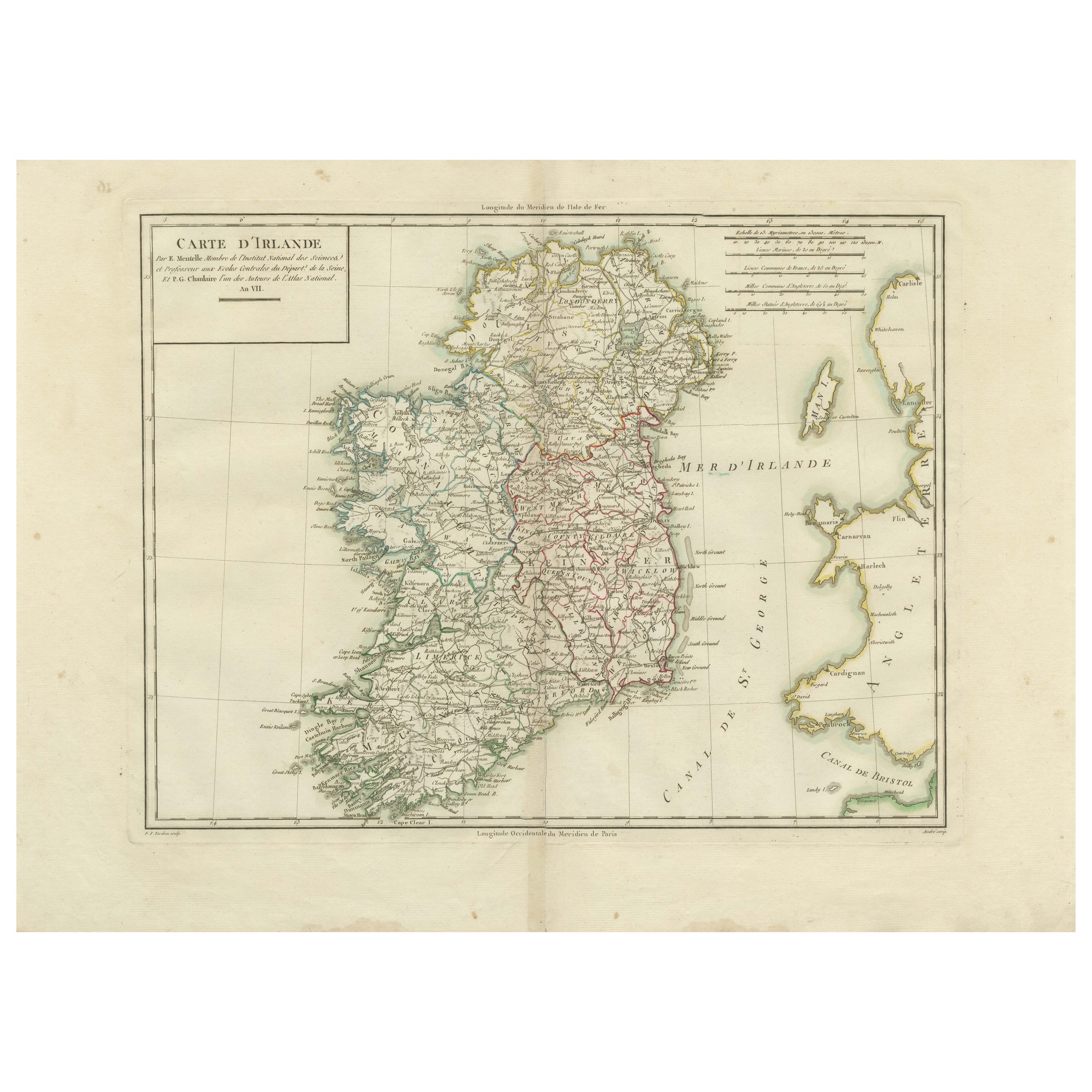
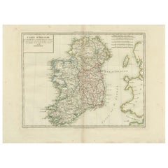
View AllMap of Ireland: Early 19th Century - from the 1802 Tardieu Atlas
Located in Langweer, NL
Antique Map Description
**Title:** Carte d'Irlande
**Publication Details:**
- **Atlas Title:** Nouvel Atlas Universel de Géographie Ancienne et Moderne
- **Purpose:** For the Nouve...
Category
Antique Early 1800s Maps
Materials
Paper
$406 Sale Price
20% Off
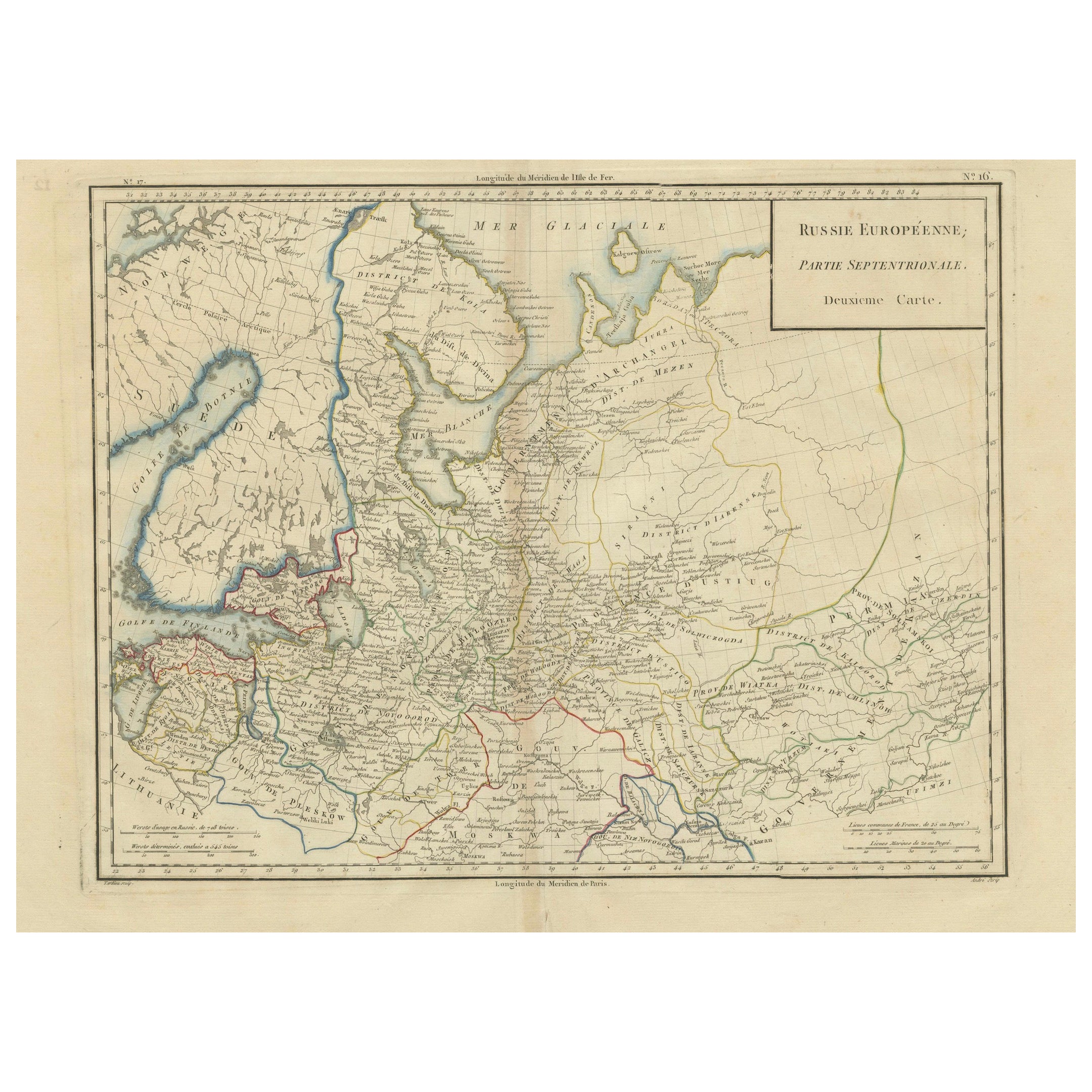
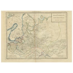
Map of Northern European Russia: Early 19th Century - 1802 Tardieu Atlas
Located in Langweer, NL
Title: Russie Européenne: Partie Septentrionale. Deuxieme Carte.
**Publication Details:**
- **Atlas Title:** Nouvel Atlas Universel de Géographie Ancienne et Moderne
- **Purpose:**...
Category
Antique Early 1800s Maps
Materials
Paper
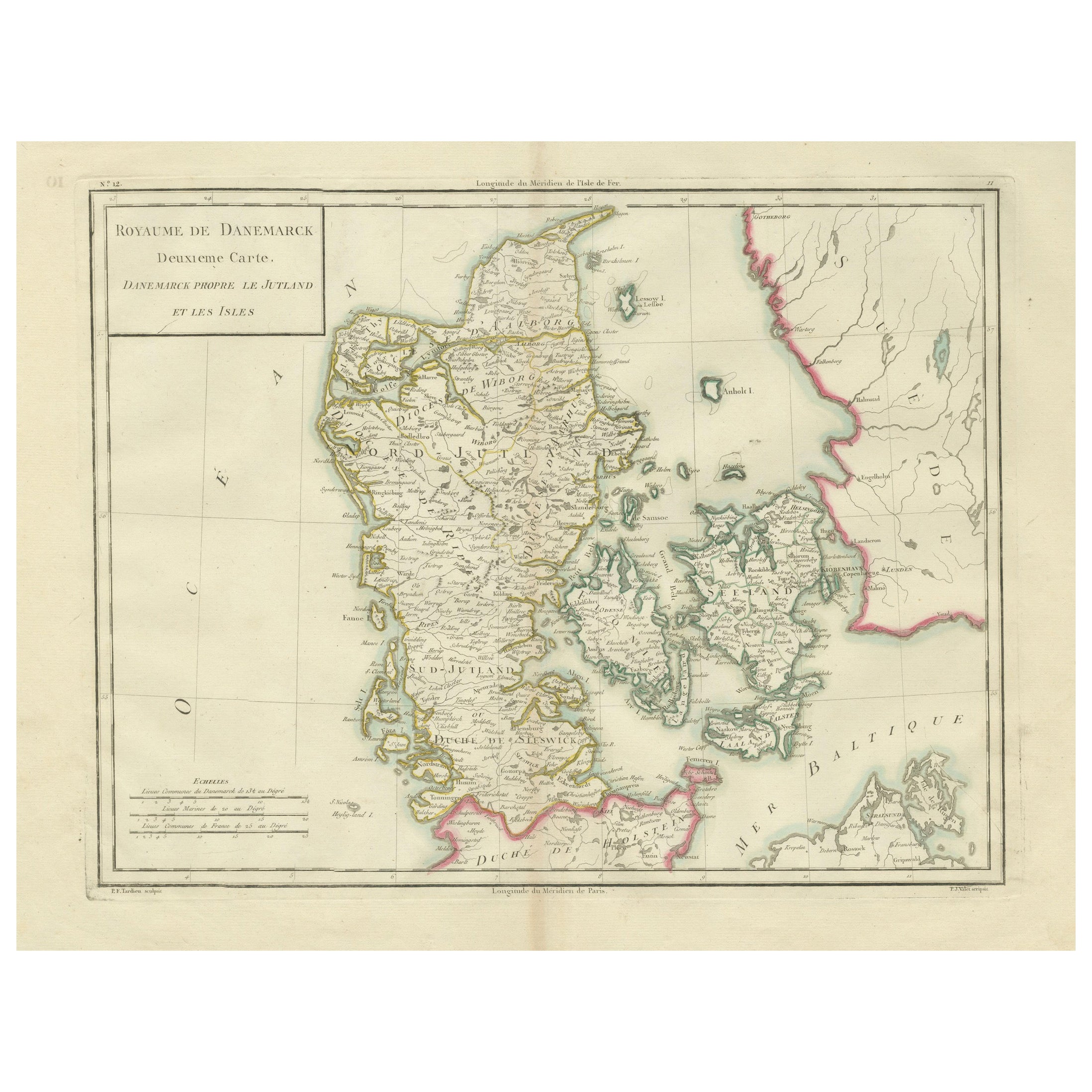
Map of Denmark Proper & Jutland: Early 19th Century from the 1802 Tardieu Atlas
Located in Langweer, NL
Antique Map with Title: "Royaume de Danemarck: Deuxieme Carte. Danemarck Propre, le Jutland et les Isles"
Publication Details:
- **Atlas Title:** Nouvel Atlas Universel de Géograp...
Category
Antique Early 1800s Maps
Materials
Paper

$406 Sale Price
20% Off
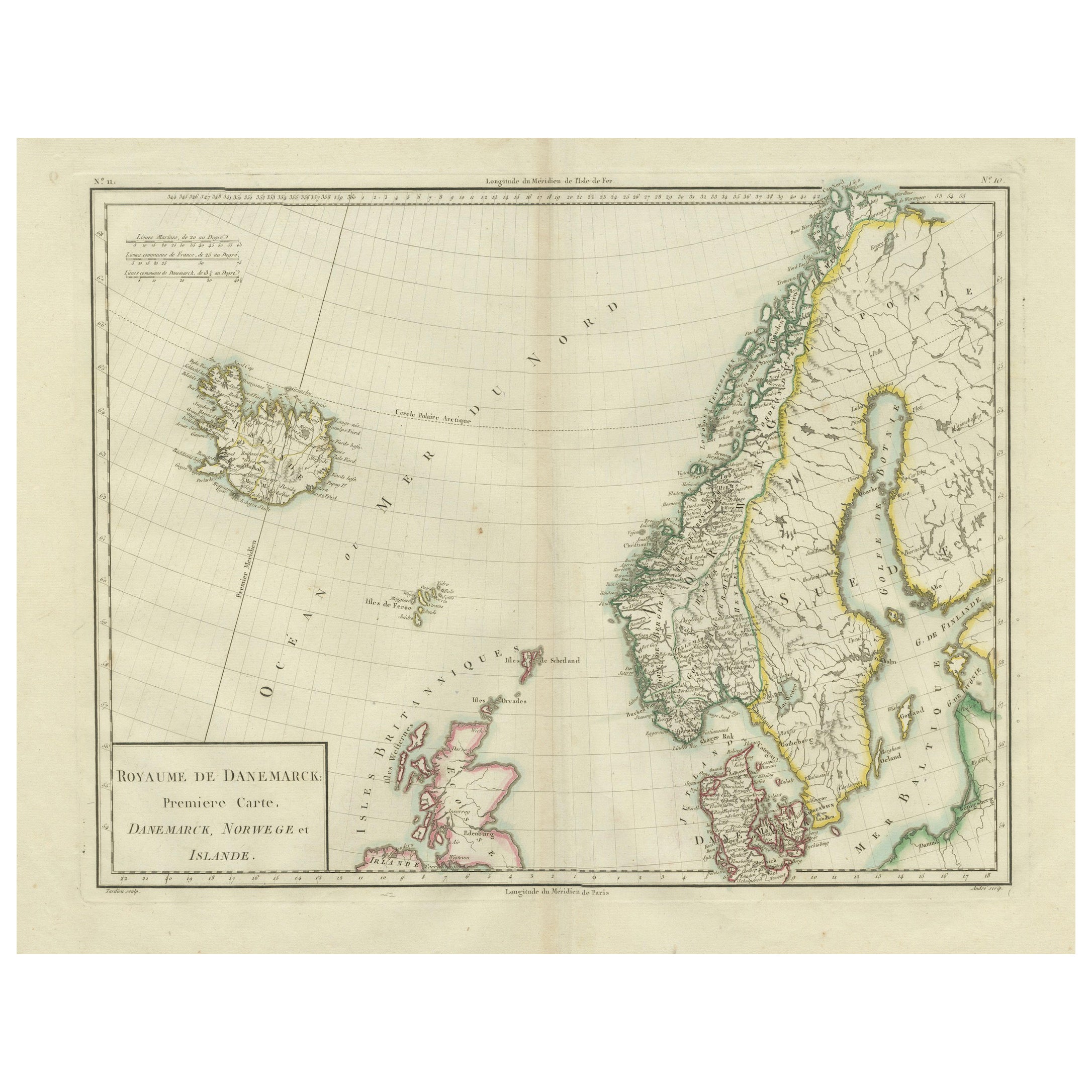
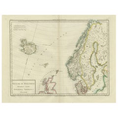
Map of Denmark, Norway & Iceland: Early 19th Century from the 1802 Tardieu Atlas
Located in Langweer, NL
Antique Map Description
Title: Royaume de Danemarck: Première Carte. Danemarck, Norwege et Islande
Publication Details:
- **Atlas Title:** Nouvel Atlas Universel de Géographie Anc...
Category
Antique Early 1800s Maps
Materials
Paper
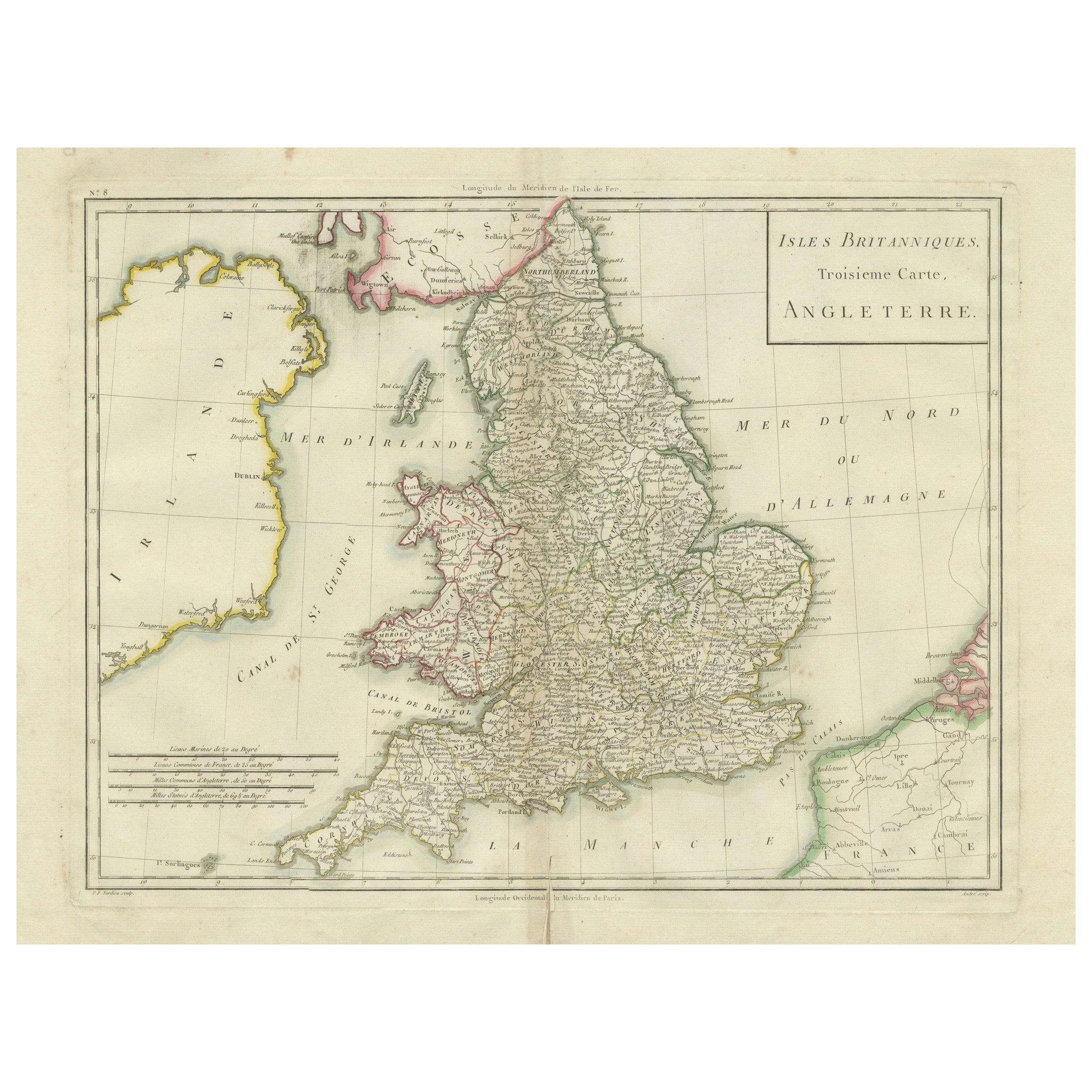
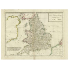
Map of England and Surrounding Regions: Early 19th Century - 1802 Tardieu Atlas
Located in Langweer, NL
Title: Isles Britanniques. Troisieme Carte, Angleterre
Publication Details:
- **Atlas Title:** Nouvel Atlas Universel de Géographie Ancienne et Moderne
- **Purpose:** For the Nouve...
Category
Antique Early 1800s Maps
Materials
Paper
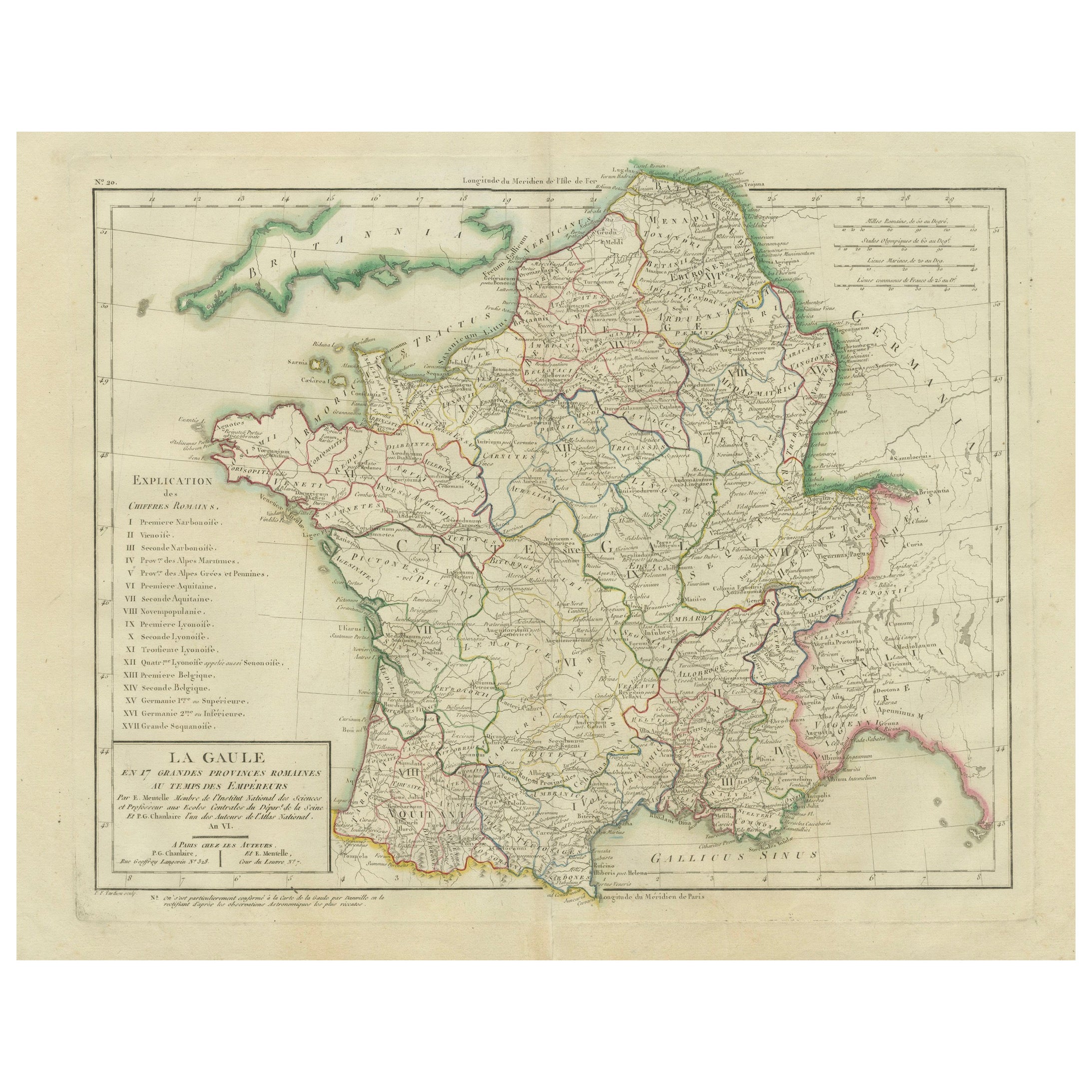
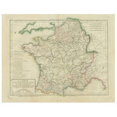
Map of Ancient Gaul & Roman Provinces: Early 19th Century - 1802 Tardieu Atlas
Located in Langweer, NL
### Antique Map Description
**Title:** La Gaule et Ses Grandes Dignités Romaines au Temps des Empereurs
**Publication Details:**
- **Atlas Title:** Nouvel Atlas Universel de Géogra...
Category
Antique Early 1800s Maps
Materials
Paper
You May Also Like
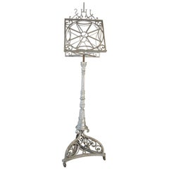
Antique Church Lectern from the Early 19th Century
Located in Udenhout, NL
The French Churches and Chapels were using these religious
lecterns from which the Holy Bible was read.
Category
Antique Early 19th Century French Religious Items
Materials
Iron
Large 19th Century Map of France
Located in Pease pottage, West Sussex
Large 19th Century Map of France.
Remarkable condition, with a pleasing age worn patina.
Recently framed.
France Circa 1874.
Category
Antique Late 19th Century French Maps
Materials
Linen, Paper

Early 19th Century Hand Colored Map of the United States and Caribbean Islands
Located in Hamilton, Ontario
Hand coloured early 19th century map by Giraldon of France titled "Etats Unis et Grandes Antilles" (United States and Greater Antilles).
Category
Antique Early 19th Century French Maps
Materials
Paper

$595 Sale Price
40% Off
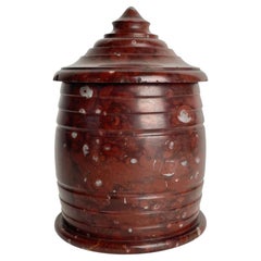
Beautiful Marble Tobacco Box from the early 19th Century
Located in Knivsta, SE
Charming Marble Tobacco Box from the early 19th Century. Beautiful color of the marble. Overall good condition, but with a few minor chips on the lid. (See pictures)
Wear consistent...
Category
Antique Early 19th Century European Tobacco Accessories
Materials
Marble
Antique Framed Pen and Ink on Fabric Map of Cornwall from Early 19th Century
Located in Los Angeles, CA
This English fabric map of Cornwall, rendered in pen-and-ink, showcases exquisite hand-drawn details and charming faded sepia tones. Encased in a classic frame, this piece elegantly ...
Category
Antique Early 19th Century English Drawings
Materials
Walnut, Fabric

Transparent blown glass laboratory retort from the early 19th century.
Located in Milan, IT
An early 19th-century transparent blown glass laboratory retort used for distillation, it has a pyriform body and long neck bent downward that gradually narrows toward the mouth.
Bo...
Category
Antique 1820s Scientific Instruments
Materials
Glass
Recently Viewed
View AllMore Ways To Browse
Mountain Ottoman
60 X 60 Ottoman
Antique Italian Ottoman
Antique 19th Century Empire Ottoman
Iron Scroll Coffee Table
Iron Scroll Console Table
Italian Rattan Stools
Italian Tumbler
Jansen Mirror Table
Japanese Export Silver
Jens Quistgaard For Dansk Teak
Karabagh Kilim
Kartell Four
King Louis Dining Table
Kitchen Furniture Bakelite
Leather Accent Chairs Pair
Library Wall Panels
Long French Bench