Items Similar to Original Old Map of Present-Day Mongolia, Northeast China and Korea


Want more images or videos?
Request additional images or videos from the seller
1 of 6
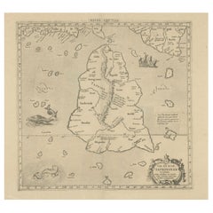
Original Old Map of Present-Day Mongolia, Northeast China and Korea
About the Item
Antique map titled 'Carte de la Tartarie Chinoise. Projettee et assujettie aux observations astronomiques par M. Bonne, Hydrographe du Roi. A Paris, Chez Lattre Graveur, ordinaire de Mseur. Le Dauphin, rue S. Jacques a la Ville de Bordeaux. Avec privilege du Roy. 1771'. Original old map of the region including present-day Mongolia, northeast China and Korea. Published in Paris by Lattré in “Atlas Moderne”, 1771. This atlas contained many maps by Rigobert Bonne.
- Dimensions:Height: 15.24 in (38.7 cm)Width: 21.19 in (53.8 cm)Depth: 0.02 in (0.5 mm)
- Materials and Techniques:
- Period:
- Date of Manufacture:1771
- Condition:Wear consistent with age and use. General age-related toning. Original folding line. Minor wear and soiling, blank verso. Small repair on tiny holes above scale. Please study image carefully.
- Seller Location:Langweer, NL
- Reference Number:Seller: BG-13370-11stDibs: LU3054332541102
About the Seller
5.0
Recognized Seller
These prestigious sellers are industry leaders and represent the highest echelon for item quality and design.
Platinum Seller
Premium sellers with a 4.7+ rating and 24-hour response times
Established in 2009
1stDibs seller since 2017
2,412 sales on 1stDibs
Typical response time: 1 hour
- ShippingRetrieving quote...Shipping from: Langweer, Netherlands
- Return Policy
Authenticity Guarantee
In the unlikely event there’s an issue with an item’s authenticity, contact us within 1 year for a full refund. DetailsMoney-Back Guarantee
If your item is not as described, is damaged in transit, or does not arrive, contact us within 7 days for a full refund. Details24-Hour Cancellation
You have a 24-hour grace period in which to reconsider your purchase, with no questions asked.Vetted Professional Sellers
Our world-class sellers must adhere to strict standards for service and quality, maintaining the integrity of our listings.Price-Match Guarantee
If you find that a seller listed the same item for a lower price elsewhere, we’ll match it.Trusted Global Delivery
Our best-in-class carrier network provides specialized shipping options worldwide, including custom delivery.More From This Seller
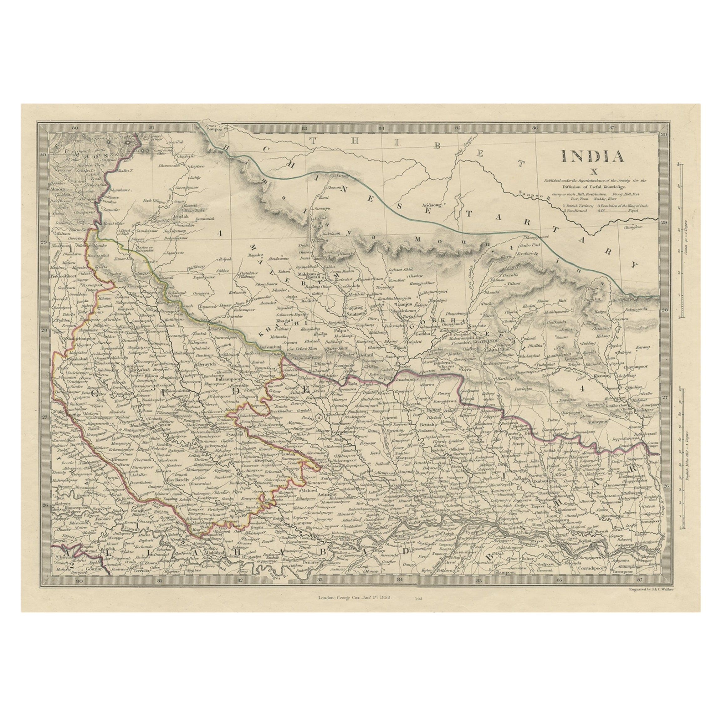
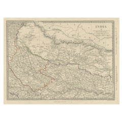
View AllOriginal Old Map Northeast India, incl Part of Himalayas and China, 1853
Located in Langweer, NL
Antique map titled 'India X'.
Old map of the the northeast region of India, including part of Himalayas and China. Great detail of landforms, rivers and water bodies, cities, towns...
Category
Antique 1850s Maps
Materials
Paper
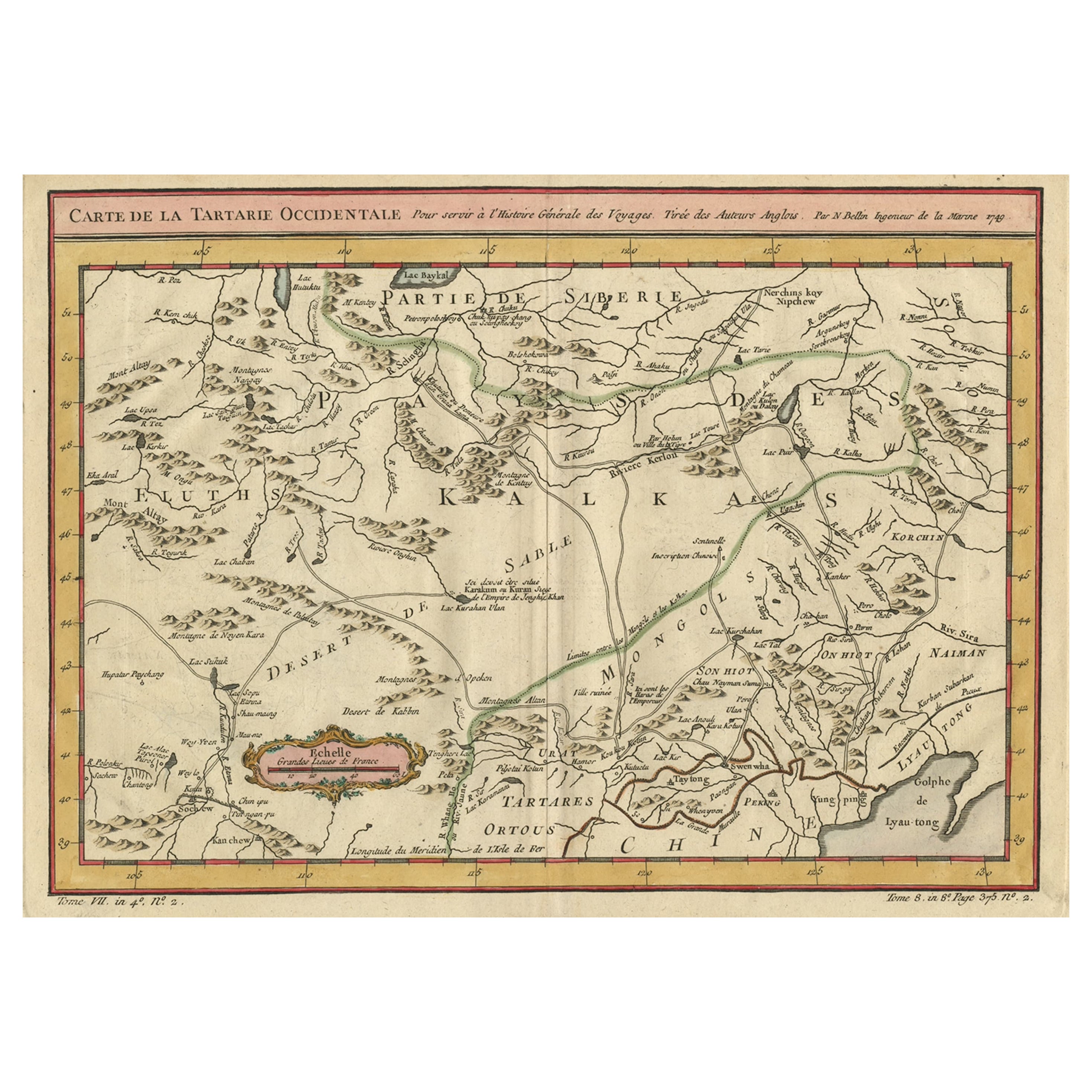
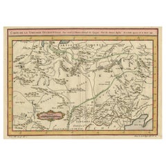
Old Hand-Colored Map of Western Tartary with Focus on Present-Day Mongolia, 1749
Located in Langweer, NL
Antique map titled 'Carte de la Tartarie Occidentale pour Servir a l'Histoire Générale des Voyages. Tirée des Auteurs Anglois.'
This map covers western Tartary and focuses on the...
Category
Antique 1740s Maps
Materials
Paper
$408 Sale Price
20% Off
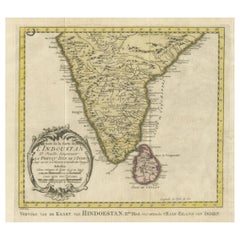
Original Antique Map of Southern India and Ceylon 'Present-Day Sri Lanka'
By Jakob van der Schley
Located in Langweer, NL
Antique map titled 'Suite de la Carte de l'Indoustan (..) - Vervolg van de Kaart van Hindoestan (..)'. Original antique map of Southern India and Ceylon (present-day Sri Lanka). This...
Category
Antique Mid-18th Century Maps
Materials
Paper
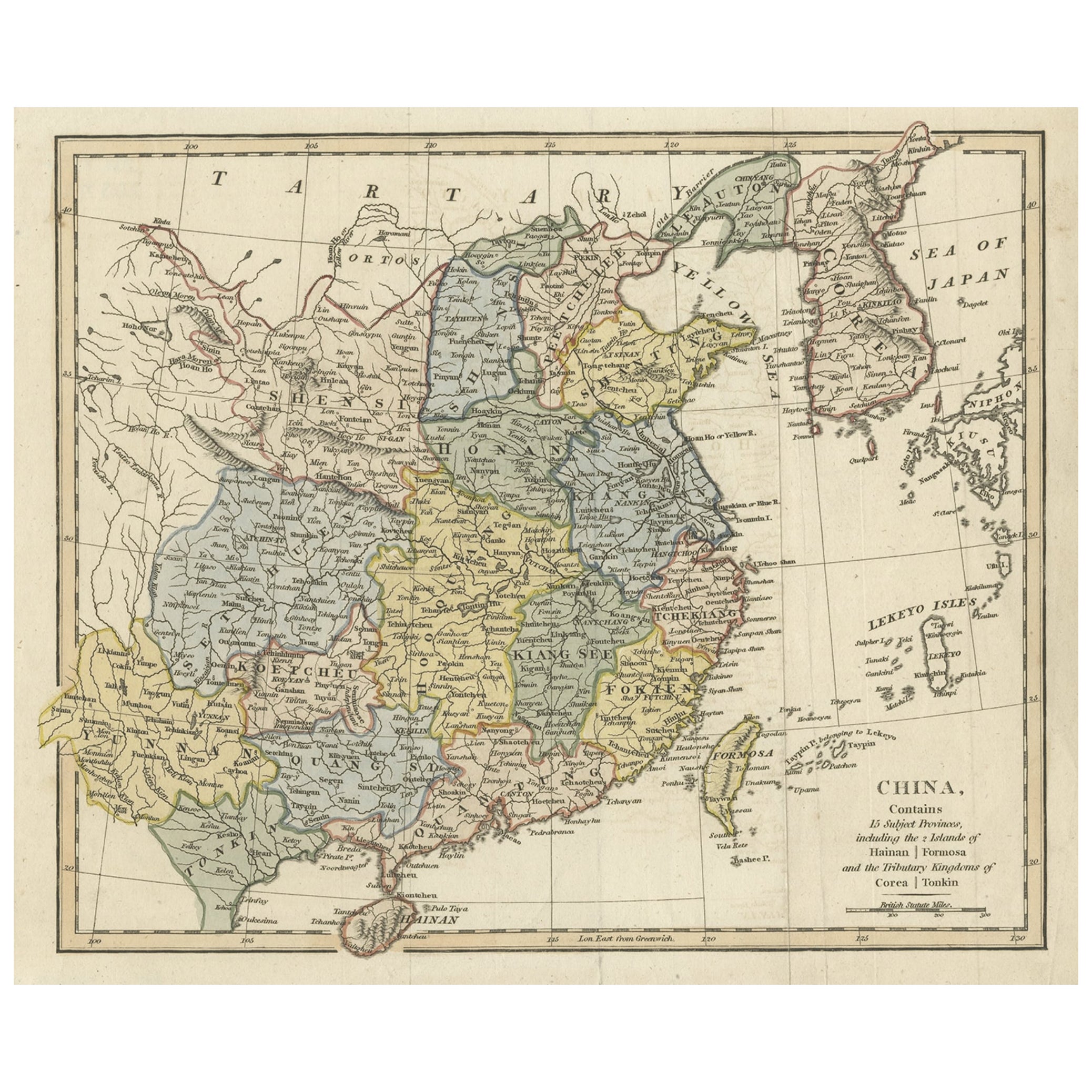
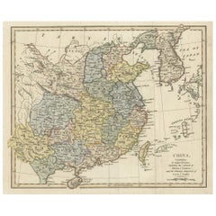
Original Old China Map, From Korea and the Sea of Japan to Teypin Island, 1803
Located in Langweer, NL
Antique map titled 'China, Contains 15 Subject Provinces Including the 2 Islands of Hainan, Formosa and the Tributary Kingdoms of Corea, Tonkin'.
Old map depicting China, extendi...
Category
Antique Early 1800s Maps
Materials
Paper
$510 Sale Price
20% Off
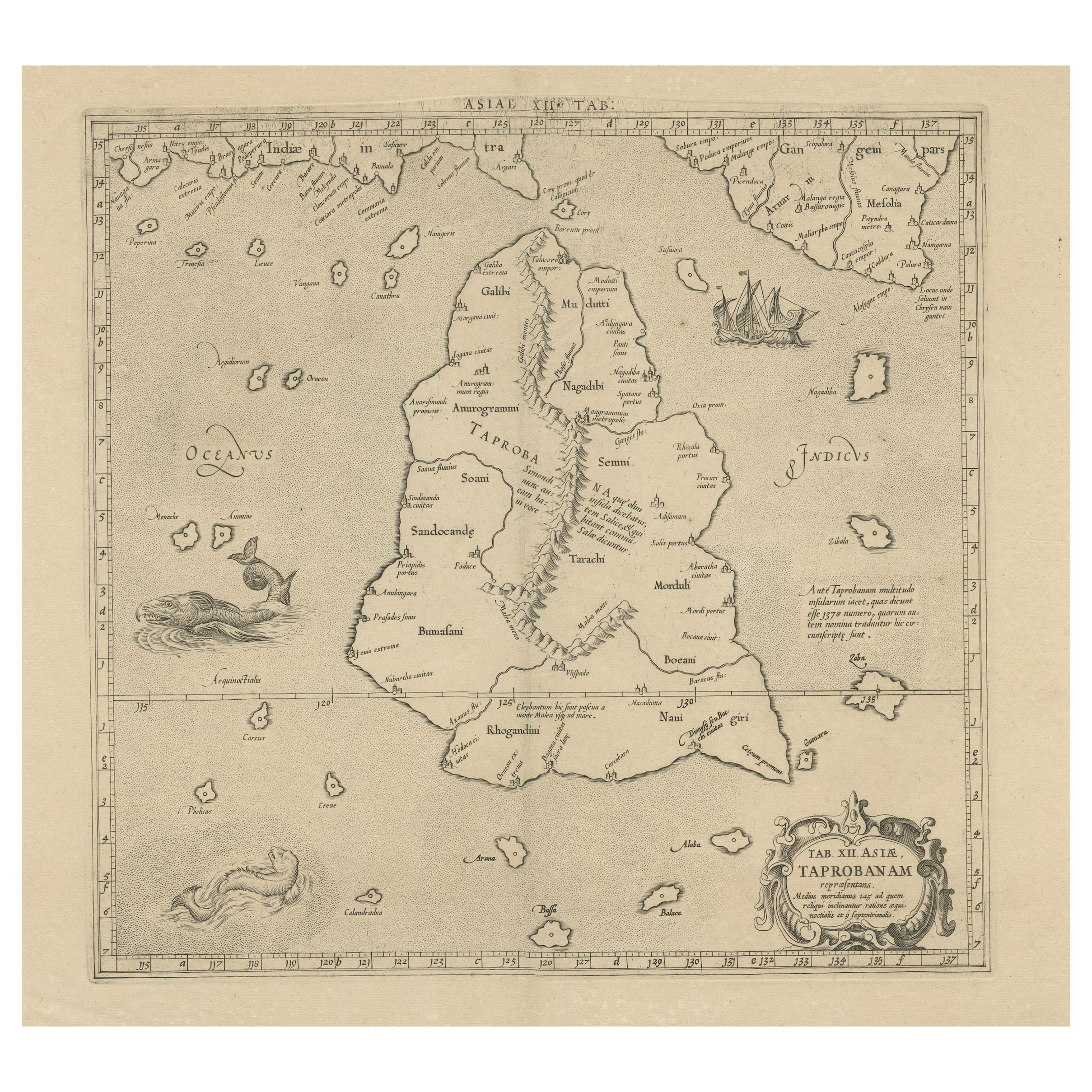
Rare Original Antique Ptolemy Map of Ceylon, Present Day Sri Lanka
Located in Langweer, NL
Original antique map titled 'Tab XII Asiae Taprobanam (..)'. For this map of Toprobana (Sri Lanka), Ptolemy drew on the accounts of travelers and sailors and though the information was secondhand and often inaccurate, it represented the most advanced account of the world's geography at that time. This map depicts the island with the typical misconceptions of the period with the enlarged island straddling the Equator and nearly divided by a ridge of mountains. A small part of India is incorrectly shown in the northeast corner of the map and a spurious coastline labeled Gangem fills the upper right corner. The stipple engraved sea contains an oriental ship...
Category
Antique Late 17th Century Maps
Materials
Paper
Antique Map of Tartary and Northeast Asia, c.1750
Located in Langweer, NL
Antique map titled 'Carte de la tartarie occidentale'. An interesting map of Tartary and northeast Asia, from Lake Baykal, Partie du Siberia in the north, Pays des Kalkas at the cent...
Category
Antique 18th Century Maps
Materials
Paper

You May Also Like
Original Antique Map of China, Arrowsmith, 1820
Located in St Annes, Lancashire
Great map of China
Drawn under the direction of Arrowsmith
Copper-plate engraving
Published by Longman, Hurst, Rees, Orme and Brown, 1820
Unfr...
Category
Antique 1820s English Maps
Materials
Paper

Old Horizontal Map of England
By Tasso
Located in Alessandria, Piemonte
ST/520 - Old rare Italian map of England, dated 1826-1827 - by Girolamo Tasso, editor in Venise, for the atlas of M.r Le-Sage.
Category
Antique Early 19th Century Italian Other Prints
Materials
Paper

Original Antique Map of Spain and Portugal, circa 1790
Located in St Annes, Lancashire
Super map of Spain and Portugal
Copper plate engraving by A. Bell
Published, circa 1790.
Unframed.
Category
Antique 1790s English Other Maps
Materials
Paper

Original Antique Map of Ireland- Tipperary and Waterford. C.1840
Located in St Annes, Lancashire
Great map of Tipperary and Waterford
Steel engraving
Drawn under the direction of A.Adlard
Published by How and Parsons, C.1840
Unframed.
Category
Antique 1840s English Maps
Materials
Paper

Original Antique Map of United States, Grattan and Gilbert, 1843
Located in St Annes, Lancashire
Great map of United States
Drawn and engraved by Archer
Published by Grattan and Gilbert. 1843
Original colour
Unframed.
Category
Antique 1840s English Maps
Materials
Paper

Original Antique Map of Ireland- Kerry. C.1840
Located in St Annes, Lancashire
Great map of Kerry
Steel engraving
Drawn under the direction of A.Adlard
Published by How and Parsons, C.1840
Unframed.
Category
Antique 1840s English Maps
Materials
Paper

Recently Viewed
View AllMore Ways To Browse
Dauphin Paris
Mongolian Antique
Old Paris China
Les Chinoise
Pair Of Vintage Leather Club Chairs
Pakistan Tabriz Carpet
Pakistan Tabriz Rug
Porcelain Bread Plate
Portuguese Leather Dining Room Chairs
Purple Ashtray
Rectangular Coffee Tables Chinese
Ribbed Side Table
Round Armchair Art Deco
Round Dining Table 180 Cm
Rounded Rosewood Dining Table
Safari Directors Chairs
Sculptural Barstool
Set Of 10 Mahogany Dining Chairs