Items Similar to Original Antique Map of Ancient Greece- Boeotia, Thebes, 1787


Want more images or videos?
Request additional images or videos from the seller
1 of 5
Original Antique Map of Ancient Greece- Boeotia, Thebes, 1787
About the Item
Great map of Ancient Greece. Showing the region of Boeotia, including Thebes
Drawn by J.D. Barbie Du Bocage
Copper plate engraving by P.F Tardieu
Original hand color outline.
Published 1785
Unframed.
- Dimensions:Height: 10 in (25.4 cm)Width: 14 in (35.56 cm)Depth: 0.07 in (1.78 mm)
- Style:Other (In the Style Of)
- Materials and Techniques:Paper,Other
- Place of Origin:
- Period:1780-1789
- Date of Manufacture:1787
- Condition:Wear consistent with age and use.
- Seller Location:St Annes, GB
- Reference Number:1stDibs: LU1836324413612
About the Seller
4.9
Platinum Seller
Premium sellers with a 4.7+ rating and 24-hour response times
1stDibs seller since 2016
3,047 sales on 1stDibs
Typical response time: <1 hour
Associations
International Confederation of Art and Antique Dealers' Associations
- ShippingRetrieving quote...Shipping from: St Annes, United Kingdom
- Return Policy
Authenticity Guarantee
In the unlikely event there’s an issue with an item’s authenticity, contact us within 1 year for a full refund. DetailsMoney-Back Guarantee
If your item is not as described, is damaged in transit, or does not arrive, contact us within 7 days for a full refund. Details24-Hour Cancellation
You have a 24-hour grace period in which to reconsider your purchase, with no questions asked.Vetted Professional Sellers
Our world-class sellers must adhere to strict standards for service and quality, maintaining the integrity of our listings.Price-Match Guarantee
If you find that a seller listed the same item for a lower price elsewhere, we’ll match it.Trusted Global Delivery
Our best-in-class carrier network provides specialized shipping options worldwide, including custom delivery.More From This Seller
View AllOriginal Antique Map of Ancient Greece, Achaia, Corinth, 1786
Located in St Annes, Lancashire
Great map of Ancient Greece. Showing the region of Thessaly, including Mount Olympus
Drawn by J.D. Barbie Du Bocage
Copper plate engraving by P.F Tardieu
Original hand color...
Category
Antique 1780s French Other Maps
Materials
Paper

Original Antique Map of Spain and Portugal, circa 1790
Located in St Annes, Lancashire
Super map of Spain and Portugal
Copper plate engraving by A. Bell
Published, circa 1790.
Unframed.
Category
Antique 1790s English Other Maps
Materials
Paper

Original Antique Map of Hungary, Arrowsmith, 1820
Located in St Annes, Lancashire
Great map of Hungary
Drawn under the direction of Arrowsmith.
Copper-plate engraving.
Published by Longman, Hurst, Rees, Orme and Brown, 1820
Unframed.
Category
Antique 1820s English Maps
Materials
Paper

Original Antique Map of Europe, Arrowsmith, 1820
Located in St Annes, Lancashire
Great map of Europe
Drawn under the direction of Arrowsmith.
Copper-plate engraving.
Published by Longman, Hurst, Rees, Orme and Brown, 1820
...
Category
Antique 1820s English Maps
Materials
Paper

Original Antique Map of South America. C.1780
Located in St Annes, Lancashire
Great map of South America
Copper-plate engraving
Published C.1780
Two small worm holes to left side of map
Unframed.
Category
Antique Early 1800s English Georgian Maps
Materials
Paper

Original Antique Map of Ireland- Kerry. C.1840
Located in St Annes, Lancashire
Great map of Kerry
Steel engraving
Drawn under the direction of A.Adlard
Published by How and Parsons, C.1840
Unframed.
Category
Antique 1840s English Maps
Materials
Paper

You May Also Like
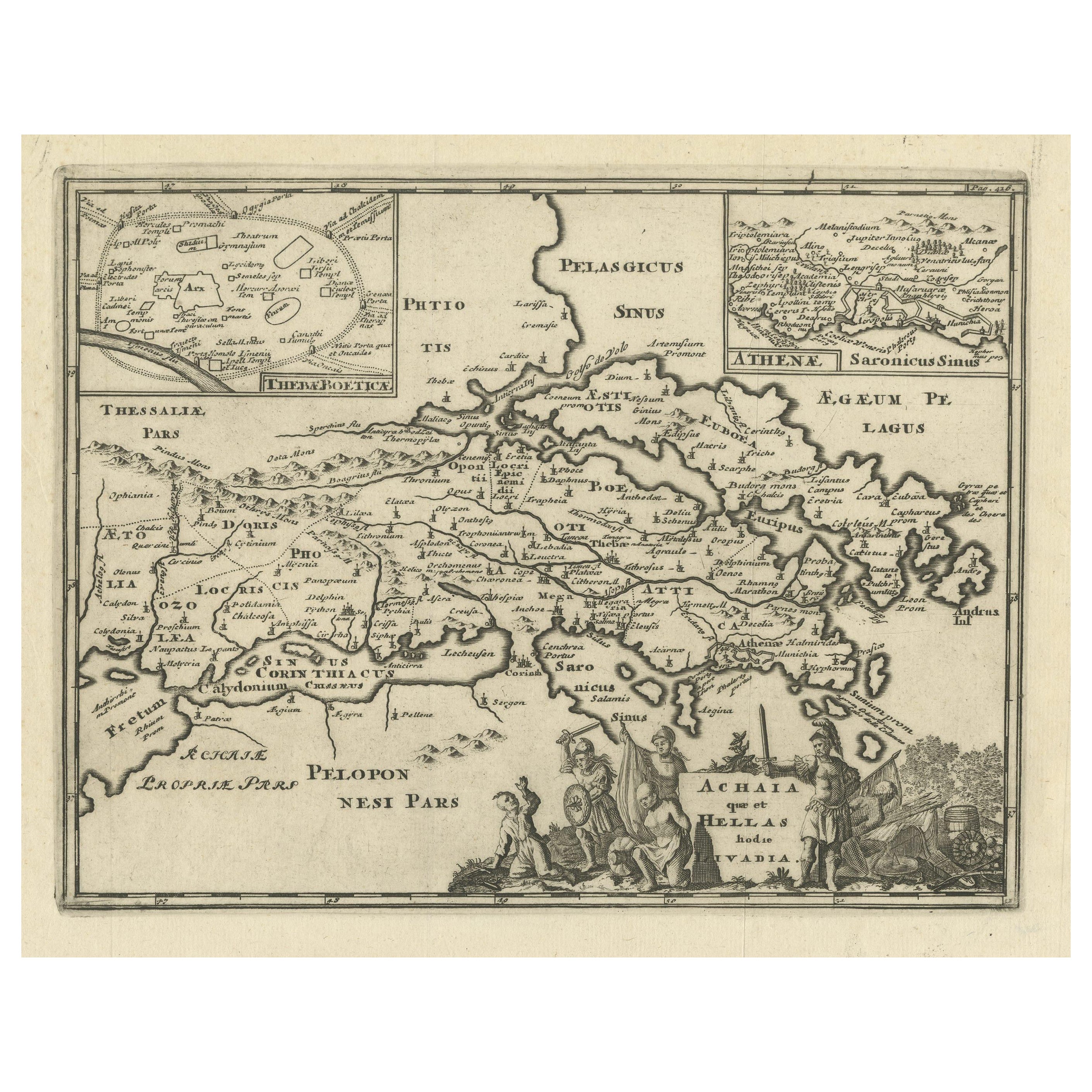
Original Antique Map of the Coast of Part of Greece, with Athens and Thebes
Located in Langweer, NL
Original antique map titled 'Achaia quae et Hellas hodie Livadia'. Detailed map of the coast of part of Greece. With inset maps of Athens and Thebes. This map originates from 'Philippi Cluveri Introductionis in universam geographiam (..)' by P. Clüver. Published 1729.
Philipp Clüver was an Early Modern German geographer and historian. Cluver's Geography was one of the most enduring works of the 17th & 18th Centuries, issued by several different publishers with many different sets of maps...
Category
Antique Early 18th Century Maps
Materials
Paper

Antique Map of Germany by Clouet, 1787
Located in Langweer, NL
Antique map titled 'L'Allemagne'. Antique map of Germany. Originates from 'Geographie moderne avec une introduction' by J.B.L. Clouet.
Category
Antique Late 18th Century Maps
Materials
Paper

$370 Sale Price
20% Off
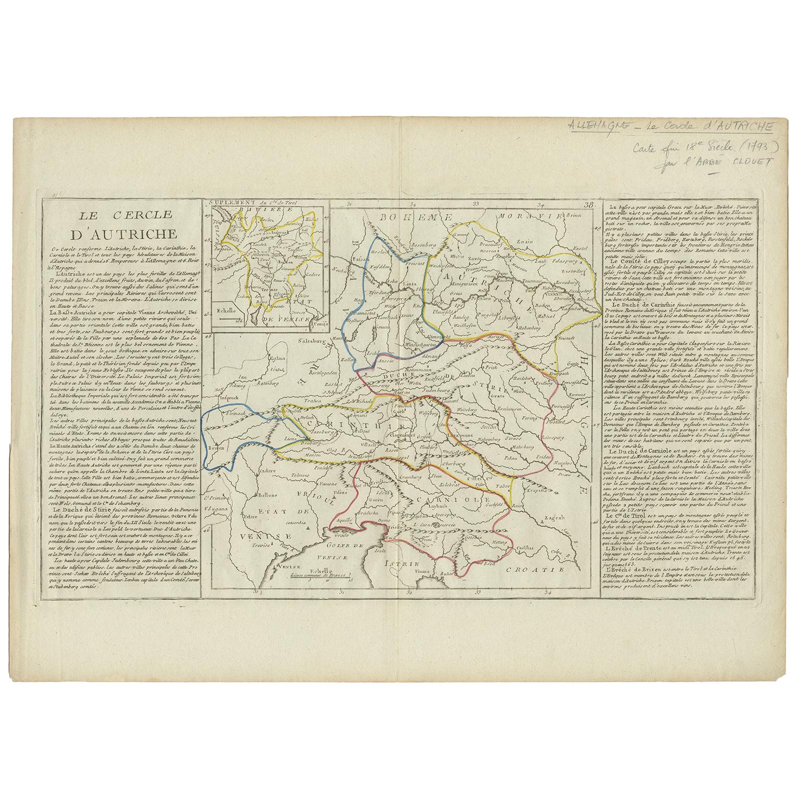
Antique Map of Austria by Clouet '1787'
Located in Langweer, NL
Antique map titled 'Le Cercle d'Autriche'. Antique map of Austria. Originates from 'Geographie moderne avec une introduction' by J.B.L. Clouet.
Category
Antique Late 18th Century Maps
Materials
Paper

$323 Sale Price
20% Off
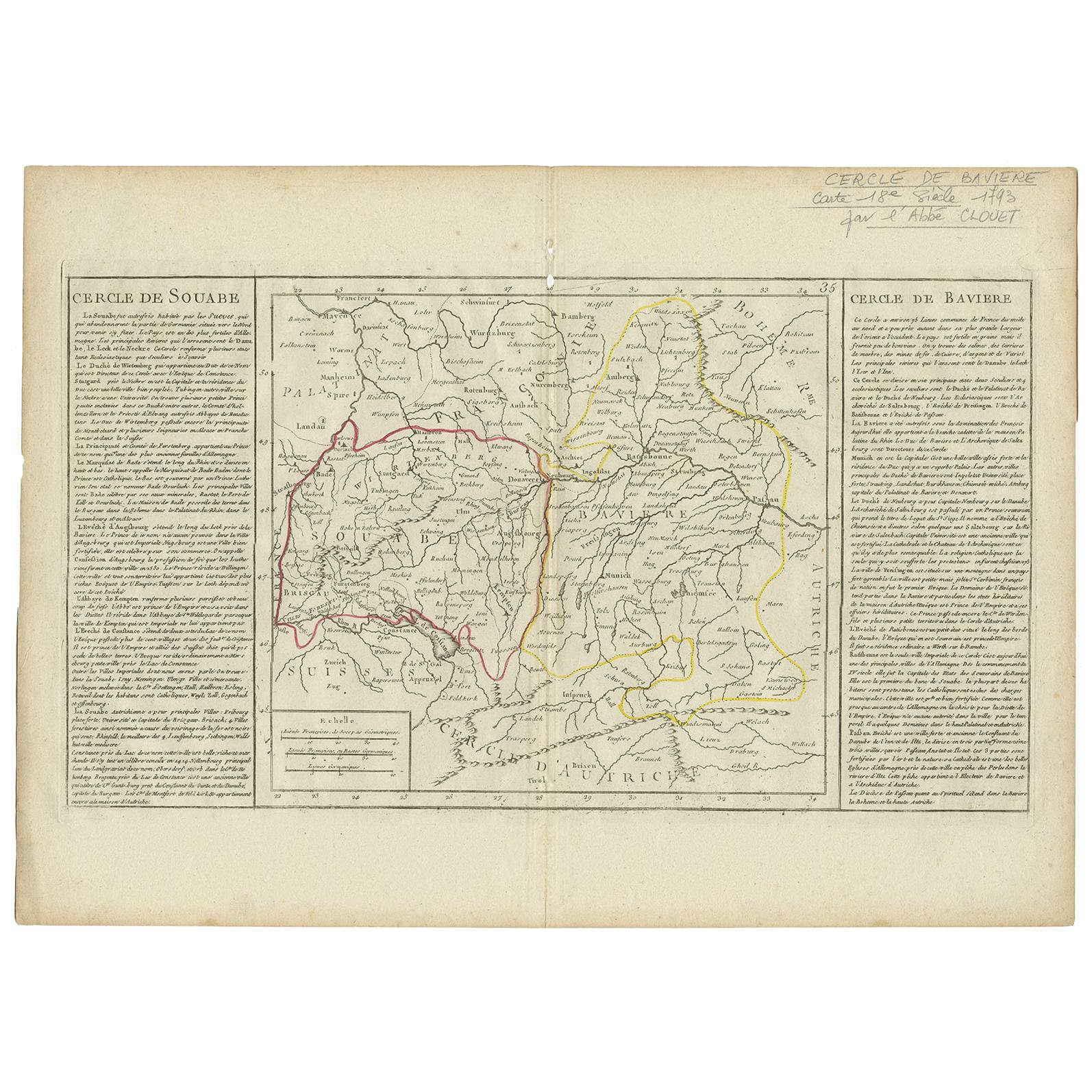
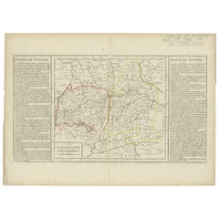
Antique Map of Swabia by Clouet, '1787'
Located in Langweer, NL
Antique map titled 'Cercle de Souabe'. Antique map of Swabia, Germany. Originates from 'Geographie moderne avec une introduction' by J.B.L. Clouet.
Category
Antique Late 18th Century Maps
Materials
Paper
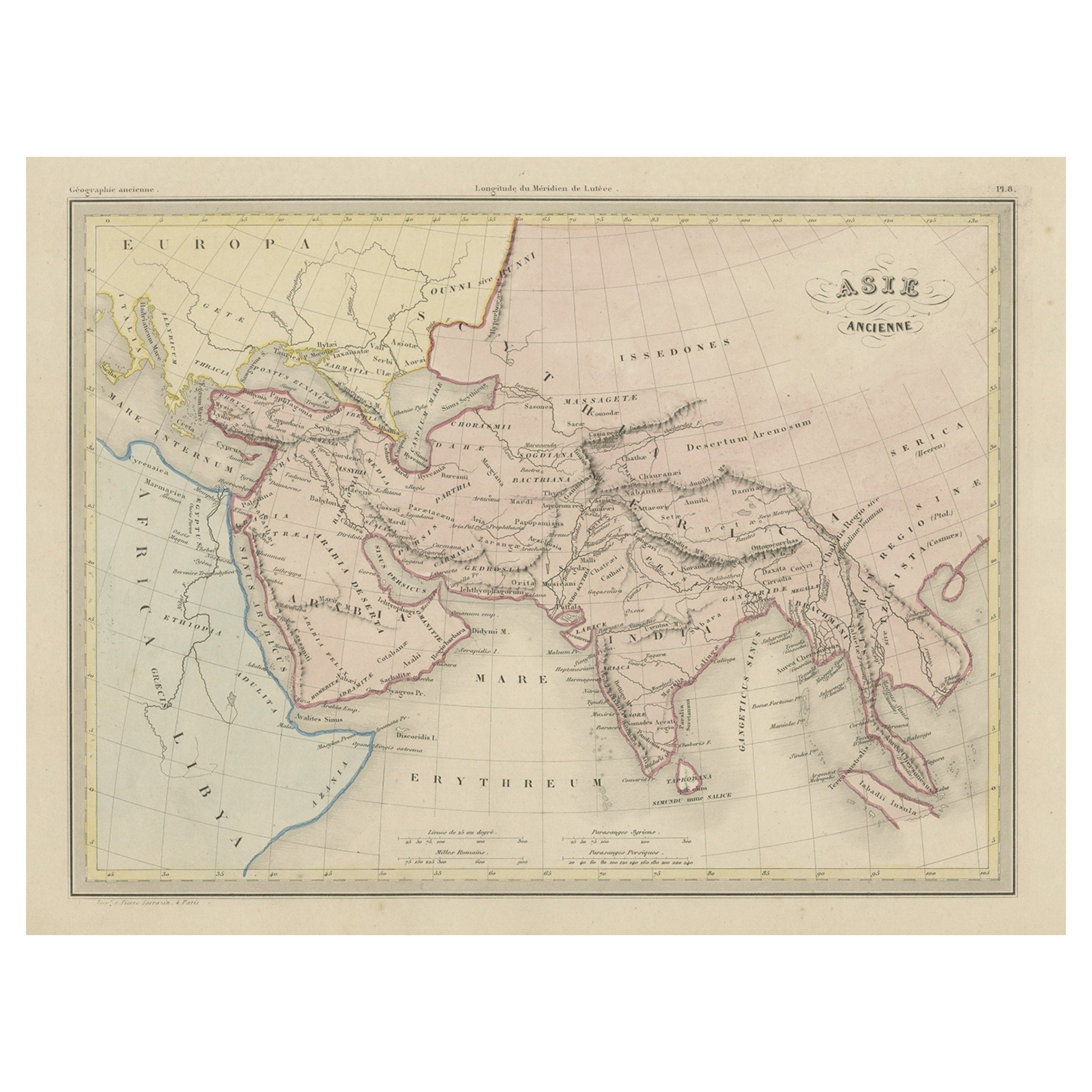
Original Antique Map of Ancient Asia, 1847
Located in Langweer, NL
Description: Antique map Asia titled 'Asie Ancienne'.
This is an original antique map of Ancient Asia and originates from 'Atlas de la Geographie ...
Category
Antique 1840s Maps
Materials
Paper

Antique Map of Lower Saxony by Clouet, 1787
Located in Langweer, NL
Antique map titled 'Basse Saxe'. Antique map of Lower Saxony, Germany. Originates from 'Geographie moderne avec une introduction' by J.B.L. Clouet.
Category
Antique Late 18th Century Maps
Materials
Paper

$277 Sale Price
20% Off
Recently Viewed
View AllMore Ways To Browse
Copper Plates Greece
Used Barbie Furniture
Gambia Antique Map
Guyana Antique Map
Mariners Chart
Papua New Guinea Antique Map
Tunisia Antique Map
Ukraine Antique Map
1720 Africa Map
Antique Map Nova Scotia
Antique Map Of Argentina
Antique Map Of Cuba
Antique Maps Of Kansas
Bermuda Map
Emden Map
George Eldridge Chart
Liverpool Map
Map Ukraine