Items Similar to Original Antique Map of Africa


Want more images or videos?
Request additional images or videos from the seller
1 of 7
Original Antique Map of Africa
About the Item
Antique map titled 'Afrika'. Original antique map of Africa, drawn by Van Beusekom. Published by 'Seyffardt's Boekhandel' in Amsterdam, circa 1870.
- Dimensions:Height: 13.39 in (34 cm)Width: 17.09 in (43.4 cm)Depth: 0.02 in (0.5 mm)
- Materials and Techniques:
- Period:
- Date of Manufacture:circa 1870
- Condition:Wear consistent with age and use. General age-related toning. Shows wear and soiling. Overall creasing. Original folding line, blank verso. Please study image carefully.
- Seller Location:Langweer, NL
- Reference Number:Seller: BG-11204-101stDibs: LU3054331109152
About the Seller
5.0
Recognized Seller
These prestigious sellers are industry leaders and represent the highest echelon for item quality and design.
Platinum Seller
Premium sellers with a 4.7+ rating and 24-hour response times
Established in 2009
1stDibs seller since 2017
2,415 sales on 1stDibs
Typical response time: 1 hour
- ShippingRetrieving quote...Shipping from: Langweer, Netherlands
- Return Policy
Authenticity Guarantee
In the unlikely event there’s an issue with an item’s authenticity, contact us within 1 year for a full refund. DetailsMoney-Back Guarantee
If your item is not as described, is damaged in transit, or does not arrive, contact us within 7 days for a full refund. Details24-Hour Cancellation
You have a 24-hour grace period in which to reconsider your purchase, with no questions asked.Vetted Professional Sellers
Our world-class sellers must adhere to strict standards for service and quality, maintaining the integrity of our listings.Price-Match Guarantee
If you find that a seller listed the same item for a lower price elsewhere, we’ll match it.Trusted Global Delivery
Our best-in-class carrier network provides specialized shipping options worldwide, including custom delivery.More From This Seller
View AllUncoulored Original Antique Map of Western Africa, 1749
Located in Langweer, NL
Interesting detailed German antique map titled 'Neue Vorstellung der Abendlaendischen Küsten von Africa (..)'. Original antique map of Western Africa. This map originates from 'Neue ...
Category
Antique Mid-18th Century Maps
Materials
Paper

$369 Sale Price
20% Off
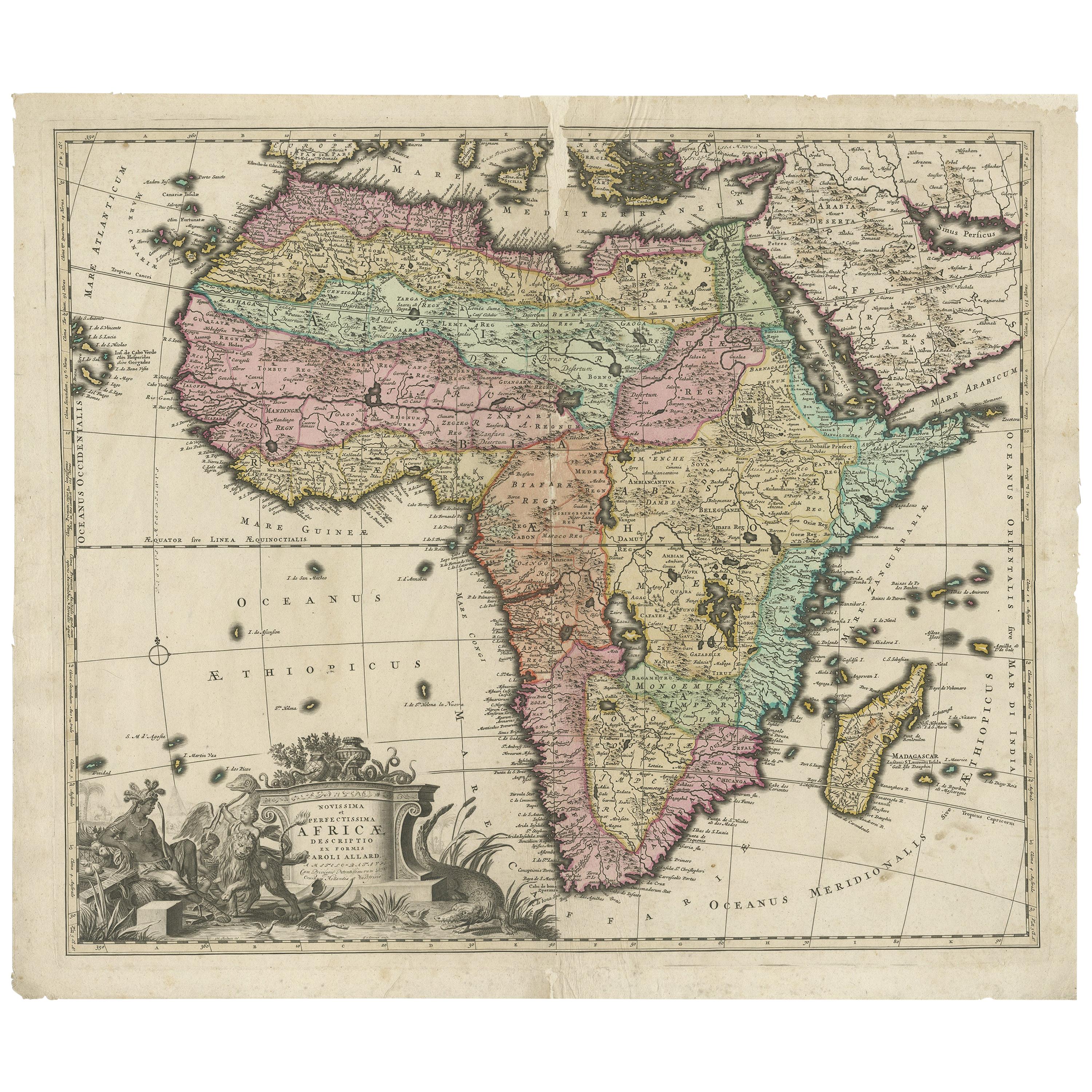
Original Antique Hand- Map of Africa by Allard '1697'
Located in Langweer, NL
Antique map titled 'Novissima et Perfectissima Africae (..)'. Beautiful large map of Africa. This is the 3rd state of the map, with climate notation add...
Category
Antique Late 17th Century Maps
Materials
Paper

$1,126 Sale Price
35% Off
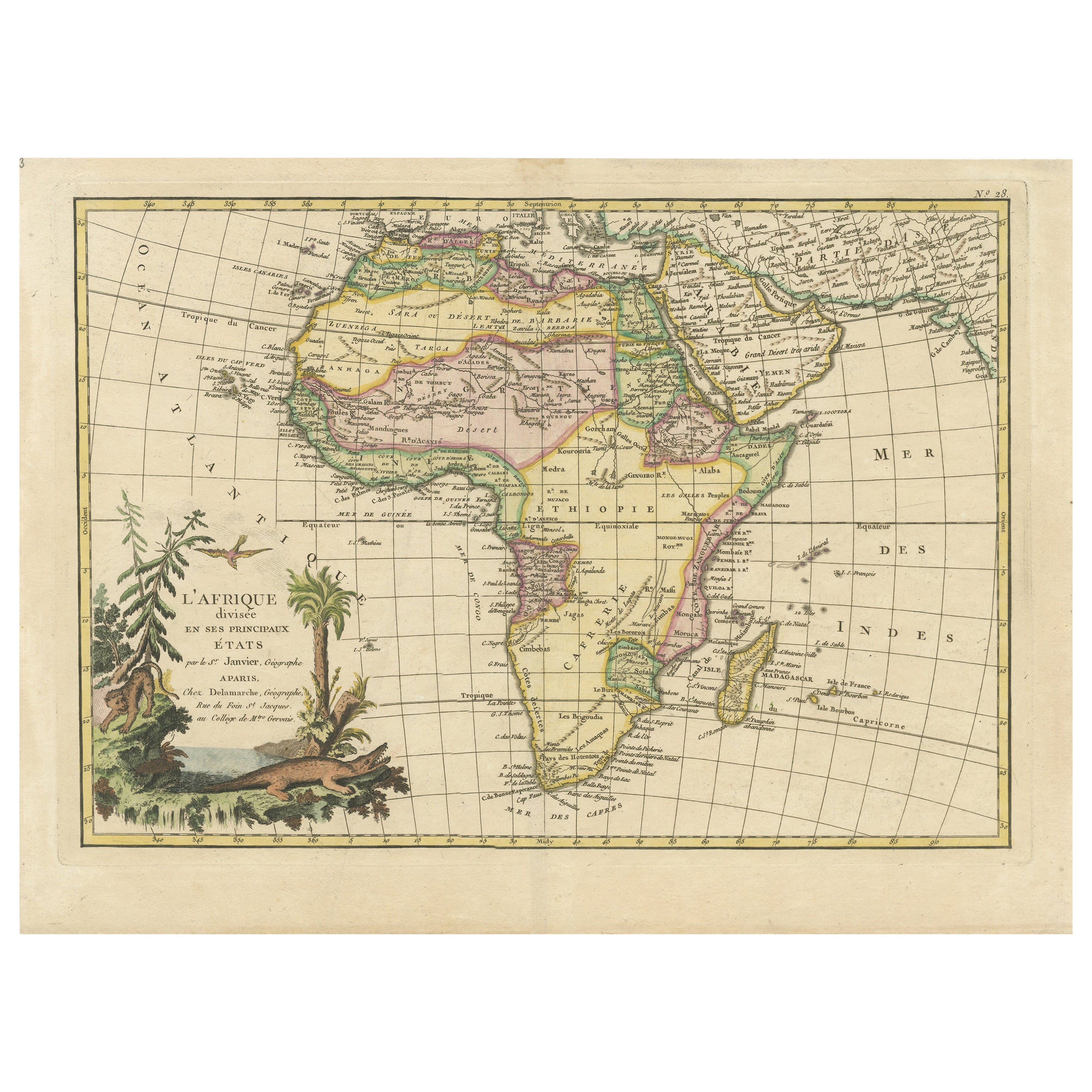
Original Antique Map of Africa with large decorative cartouche
Located in Langweer, NL
Original antique map titled 'L'Afrique divisée en ses principaux États'. Attractive and precise map of Africa, with large decorative cartouche. Engraved by Janvier. Published by Dela...
Category
Antique Late 18th Century Maps
Materials
Paper

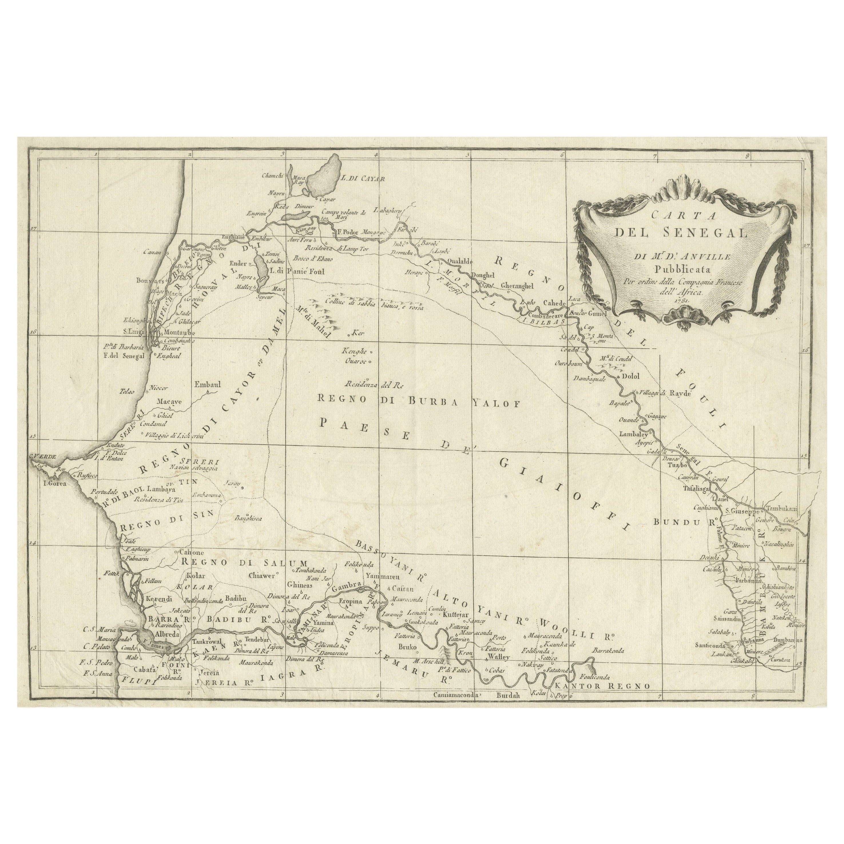
Antique Map of Senegal, West Africa
Located in Langweer, NL
Original antique map titled 'Carta del Senegal'. Antique map of Senegal, West Africa. This map originates from 'Compendio della storia generale dei viaggi (..)'. Published by De la Harpe...
Category
Antique Mid-18th Century Maps
Materials
Paper
Original Antique Map of Northern Africa by Van Dùren (1749)
Located in Langweer, NL
This is a German antique map titled 'Neue Geographische Vorstellung der Mitternaechtlichen Küste von Africa'. Original antique engraving of Northern Africa extending from the Strait ...
Category
Antique Mid-18th Century Maps
Materials
Paper

Original Hand-Colored Antique Map of Africa by Elwe '1792'
Located in Langweer, NL
Antique map titled 'l'Afrique Divisée en ses Empires, Royaumes, et Etats'. Decorative large map of Africa. The cartography is typical for the 17th century with the Nile originating i...
Category
Antique Late 18th Century Maps
Materials
Paper

You May Also Like
Original Antique Map of South Africa, Arrowsmith, 1820
Located in St Annes, Lancashire
Great map of South Africa.
Drawn under the direction of Arrowsmith.
Copper-plate engraving.
Published by Longman, Hurst, Rees, Orme and Br...
Category
Antique 1820s English Maps
Materials
Paper

Original Antique Map of Hungary, Arrowsmith, 1820
Located in St Annes, Lancashire
Great map of Hungary
Drawn under the direction of Arrowsmith.
Copper-plate engraving.
Published by Longman, Hurst, Rees, Orme and Brown, 1820
Unframed.
Category
Antique 1820s English Maps
Materials
Paper

Original Antique Map of Europe, Arrowsmith, 1820
Located in St Annes, Lancashire
Great map of Europe
Drawn under the direction of Arrowsmith.
Copper-plate engraving.
Published by Longman, Hurst, Rees, Orme and Brown, 1820
...
Category
Antique 1820s English Maps
Materials
Paper

Original Antique Map of South America. C.1780
Located in St Annes, Lancashire
Great map of South America
Copper-plate engraving
Published C.1780
Two small worm holes to left side of map
Unframed.
Category
Antique Early 1800s English Georgian Maps
Materials
Paper

Original Antique Map of Ireland- Kerry. C.1840
Located in St Annes, Lancashire
Great map of Kerry
Steel engraving
Drawn under the direction of A.Adlard
Published by How and Parsons, C.1840
Unframed.
Category
Antique 1840s English Maps
Materials
Paper

Original Antique Map of China, Arrowsmith, 1820
Located in St Annes, Lancashire
Great map of China
Drawn under the direction of Arrowsmith
Copper-plate engraving
Published by Longman, Hurst, Rees, Orme and Brown, 1820
Unfr...
Category
Antique 1820s English Maps
Materials
Paper

Recently Viewed
View AllMore Ways To Browse
Curved Back Settee Sofa
Danish Tufted Chair
Easy Chair Grey
English Wood Bench
Expandable Glass Tables
Farmhouse Consoles
Figured Walnut Side Table
Flora Fauna Plate
French Louis Xv Bureau Plat
French Metal Chair With Leather Seat
French Round Table With Leaves
Georg Jensen Acorn
German Coffee Pot
Gilt Embroidery
Glass Dining Table And Leather Chairs
Gold Moser Glass
Hand Painted Herend Hungary
Handmade Turkey Decoration