Items Similar to Original Antique Hand- Map of Africa by Allard '1697'


Want more images or videos?
Request additional images or videos from the seller
1 of 6
Original Antique Hand- Map of Africa by Allard '1697'
About the Item
Antique map titled 'Novissima et Perfectissima Africae (..)'. Beautiful large map of Africa. This is the 3rd state of the map, with climate notation added in border (1697, Betz 162, Norwich 54). Very decorative cartouche. Published by A. Allard, 1697.
- Dimensions:Height: 21.66 in (55 cm)Width: 25.2 in (64 cm)Depth: 0.02 in (0.5 mm)
- Materials and Techniques:
- Period:Late 17th Century
- Date of Manufacture:1697
- Condition:Repaired: Professional repairs on folding line. General age-related toning, minor wear and soiling. Blank verso. Please study images carefully.
- Seller Location:Langweer, NL
- Reference Number:Seller: BG-123861stDibs: LU3054324673072
About the Seller
5.0
Recognized Seller
These prestigious sellers are industry leaders and represent the highest echelon for item quality and design.
Platinum Seller
Premium sellers with a 4.7+ rating and 24-hour response times
Established in 2009
1stDibs seller since 2017
2,415 sales on 1stDibs
Typical response time: 1 hour
- ShippingRetrieving quote...Shipping from: Langweer, Netherlands
- Return Policy
Authenticity Guarantee
In the unlikely event there’s an issue with an item’s authenticity, contact us within 1 year for a full refund. DetailsMoney-Back Guarantee
If your item is not as described, is damaged in transit, or does not arrive, contact us within 7 days for a full refund. Details24-Hour Cancellation
You have a 24-hour grace period in which to reconsider your purchase, with no questions asked.Vetted Professional Sellers
Our world-class sellers must adhere to strict standards for service and quality, maintaining the integrity of our listings.Price-Match Guarantee
If you find that a seller listed the same item for a lower price elsewhere, we’ll match it.Trusted Global Delivery
Our best-in-class carrier network provides specialized shipping options worldwide, including custom delivery.More From This Seller
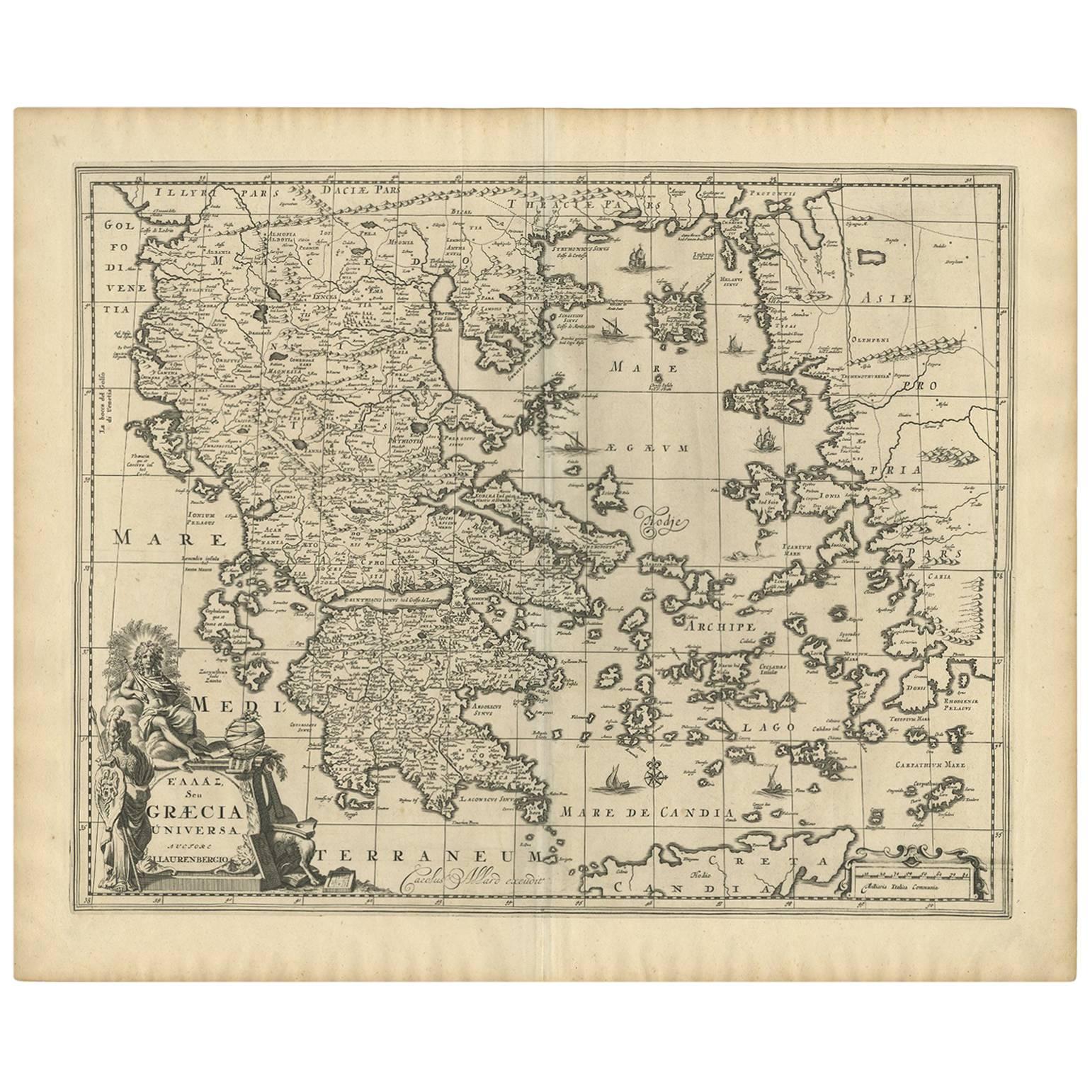
View AllAntique Map of Greece by Allard (c.1698)
Located in Langweer, NL
Antique map titled 'Hellas seu Graecia Universa' Detailed map of Greece, with Crete, the Aegean Islands, and part of Turkey. With two cartouches, compass rose and scale. Carolus Alla...
Category
Antique Late 17th Century Maps
Materials
Paper
$905 Sale Price
20% Off
Original Antique Map of Africa
Located in Langweer, NL
Antique map titled 'Afrika'. Original antique map of Africa, drawn by Van Beusekom. Published by 'Seyffardt's Boekhandel' in Amsterdam, circa 1870.
Category
Antique Late 19th Century Maps
Materials
Paper

$314 Sale Price
20% Off
Original Hand-Colored Antique Map of Africa by Elwe '1792'
Located in Langweer, NL
Antique map titled 'l'Afrique Divisée en ses Empires, Royaumes, et Etats'. Decorative large map of Africa. The cartography is typical for the 17th century with the Nile originating i...
Category
Antique Late 18th Century Maps
Materials
Paper

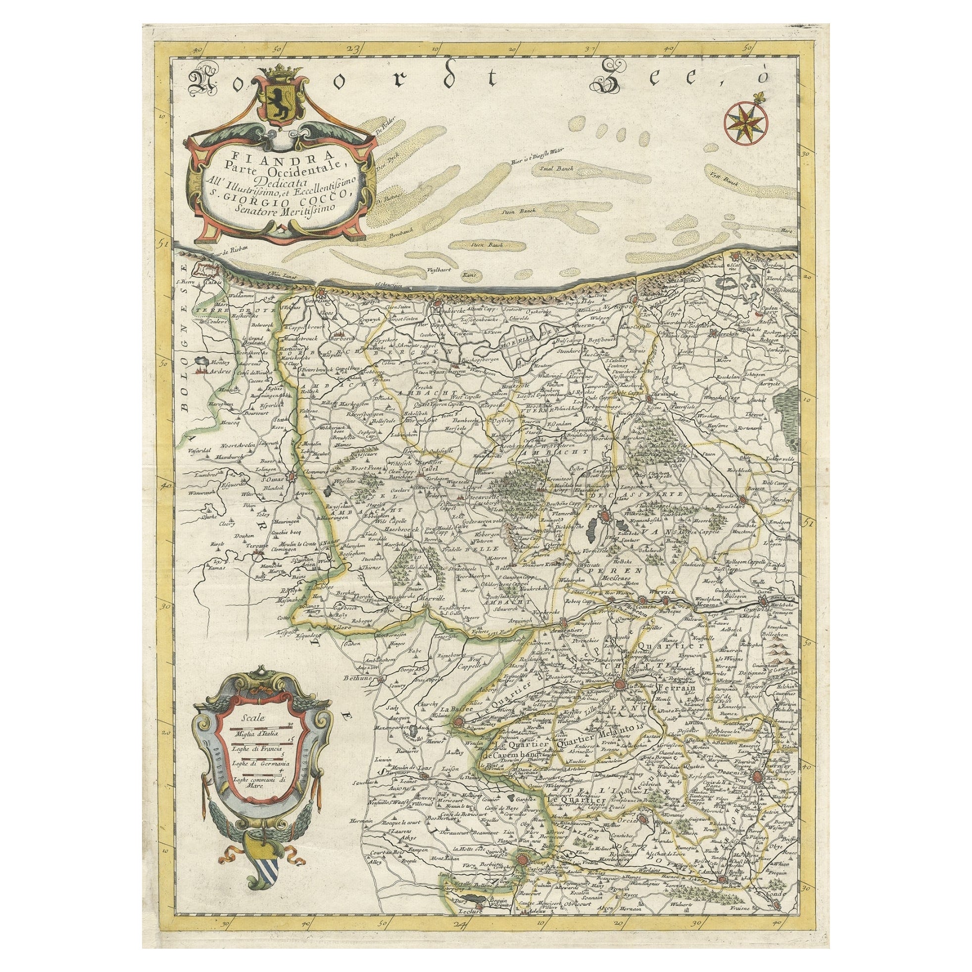
Decorative Original Antique Map of the North of Flanders, Belgium, 1697
Located in Langweer, NL
Antique map titled 'Fiandra Parte Occidentale (..)'.
Depicts northern part of Flanders, from North Sea, extends through the northern region of France to the cities of Douai and V...
Category
Antique 1690s Maps
Materials
Paper
$850 Sale Price
20% Off
Uncoulored Original Antique Map of Western Africa, 1749
Located in Langweer, NL
Interesting detailed German antique map titled 'Neue Vorstellung der Abendlaendischen Küsten von Africa (..)'. Original antique map of Western Africa. This map originates from 'Neue ...
Category
Antique Mid-18th Century Maps
Materials
Paper

$369 Sale Price
20% Off
Original Antique Map of Northern Africa by Van Dùren (1749)
Located in Langweer, NL
This is a German antique map titled 'Neue Geographische Vorstellung der Mitternaechtlichen Küste von Africa'. Original antique engraving of Northern Africa extending from the Strait ...
Category
Antique Mid-18th Century Maps
Materials
Paper

You May Also Like
Original Antique Map of South Africa, Arrowsmith, 1820
Located in St Annes, Lancashire
Great map of South Africa.
Drawn under the direction of Arrowsmith.
Copper-plate engraving.
Published by Longman, Hurst, Rees, Orme and Br...
Category
Antique 1820s English Maps
Materials
Paper

"Africa Vetus": a 17th Century Hand-Colored Map by Sanson
By Nicolas Sanson
Located in Alamo, CA
This original hand-colored copperplate engraved map of Africa entitled "Africa Vetus, Nicolai Sanson Christianiss Galliar Regis Geographi" was originally created by Nicholas Sanson d...
Category
Antique Late 17th Century French Maps
Materials
Paper

Original Antique Map of Sweden, Engraved by Barlow, 1806
Located in St Annes, Lancashire
Great map of Sweden
Copper-plate engraving by Barlow
Published by Brightly & Kinnersly, Bungay, Suffolk. 1806
Unframed.
Category
Antique Early 1800s English Maps
Materials
Paper

Original Antique Map of Europe, Arrowsmith, 1820
Located in St Annes, Lancashire
Great map of Europe
Drawn under the direction of Arrowsmith.
Copper-plate engraving.
Published by Longman, Hurst, Rees, Orme and Brown, 1820
...
Category
Antique 1820s English Maps
Materials
Paper

Original Antique Map of South America. C.1780
Located in St Annes, Lancashire
Great map of South America
Copper-plate engraving
Published C.1780
Two small worm holes to left side of map
Unframed.
Category
Antique Early 1800s English Georgian Maps
Materials
Paper

Original Antique Map of Ireland- Kerry. C.1840
Located in St Annes, Lancashire
Great map of Kerry
Steel engraving
Drawn under the direction of A.Adlard
Published by How and Parsons, C.1840
Unframed.
Category
Antique 1840s English Maps
Materials
Paper

Recently Viewed
View AllMore Ways To Browse
Used Furniture Norwich
Map Ukraine
Scan Globe
Serbia Antique Map
Shetland Map
Cham Antiques
Civil War Virginia Map
Map Of Cumberland
Map Of Virginia Civil War
Antique Furniture Trinidad
Antique Kiel Furniture
Antique Map Of Brooklyn
Antique Maps Of Maryland
Cham Kingdom
Gloucestershire Antique Map
Map Gloucestershire
Map Of Ibiza
Map Of Native American Tribes