Items Similar to OriginaAntique 17th-Century Map of Guizhou Province, China – (Qveichev) by Blaeu


Want more images or videos?
Request additional images or videos from the seller
1 of 6
OriginaAntique 17th-Century Map of Guizhou Province, China – (Qveichev) by Blaeu
About the Item
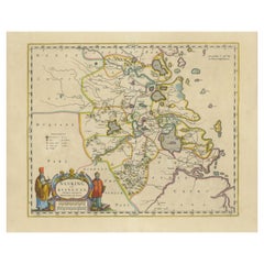
Title: Antique 17th-Century Map of Guizhou Province, China – "Qveichev" by Blaeu, Richly Illustrated and Colored
Description: This remarkable map of Guizhou Province, historically known as "Qveichev," was created by Johannes Blaeu and published in 1655 as part of his *Novus Atlas Sinensis*. This atlas, developed in collaboration with Jesuit missionary Martino Martini, marked the first Western attempt at a comprehensive geographic representation of China. Blaeu’s map offers a detailed depiction of the mountainous terrain, rivers, and towns of Guizhou, a province known for its rugged beauty and cultural diversity.
The map is adorned with two decorative cartouches, each reflecting the artistic and cultural influences of the time. The title cartouche in the lower-right corner features two figures in traditional Chinese attire, symbolizing the blend of European cartographic mastery and Chinese heritage. The upper-left corner includes a secondary cartouche with an explanatory key, adding a touch of elegance to the map’s functionality. Towns, mountains, and rivers are meticulously labeled in Latin, showcasing Blaeu’s dedication to detail and accuracy.
Crafted using the copperplate engraving technique, this map demonstrates exceptional precision. The hand-coloring enhances its visual appeal, highlighting borders and geographic features with vibrant tones. Blaeu’s work is not only a tool for geographic understanding but also a piece of art that embodies the spirit of exploration during the Dutch Golden Age.
Guizhou Province, historically known as "Qveichev," is renowned for its breathtaking natural landscapes, rich ethnic diversity, and historical significance. As one of China's most mountainous regions, Guizhou is characterized by dramatic karst formations, lush green hills, and cascading waterfalls. The province is also home to a variety of ethnic minority groups, including the Miao, Dong, and Bouyei, whose traditions, colorful costumes, and vibrant festivals make the region culturally significant.
Famous features and important places include Huangguoshu Waterfall, one of Asia's largest and most iconic waterfalls, located near the city of Anshun. Zhijin Cave, a vast karst cave system, is celebrated for its stunning stalactites and stalagmites. Kaili is known as the cultural center of Miao traditions, with picturesque villages and celebrated festivals. Zunyi holds historical importance for the Zunyi Conference, a pivotal event in the Chinese Communist Party's history. Fanjing Mountain, a UNESCO World Heritage Site, stands out for its unique biodiversity and sacred Buddhist sites.
Keywords: antique map of China, Guizhou map, Qveichev, 17th-century China map, Blaeu map, Novus Atlas Sinensis, Martino Martini, historical Chinese provinces, decorative cartouche, collectible map, copperplate engraving, hand-colored map, karst landscapes, Great Wall of China region, and Chinese history and geography.
Condition: Excellent. Clean impression with vivid hand-coloring and wide margins. Minimal age-toning consistent with the map’s age.
Framing Tips: A double mat in neutral or muted tones and an ornate gilt frame will emphasize the historic and artistic value of this piece. UV-protective glass is essential to preserve the vibrant hand-coloring and delicate engraving.
- Dimensions:Height: 18.9 in (48 cm)Width: 23.04 in (58.5 cm)Depth: 0.01 in (0.2 mm)
- Materials and Techniques:Paper,Engraved
- Period:1650-1659
- Date of Manufacture:1655
- Condition:Condition: Excellent and rare in this condition, considering the map is almost 400 years old! Strong impression with vibrant hand-coloring and wide margins. Light age-toning typical of a work of this period.
- Seller Location:Langweer, NL
- Reference Number:Seller: BGCP-0111stDibs: LU3054343470372
About the Seller
5.0
Recognized Seller
These prestigious sellers are industry leaders and represent the highest echelon for item quality and design.
Platinum Seller
Premium sellers with a 4.7+ rating and 24-hour response times
Established in 2009
1stDibs seller since 2017
2,415 sales on 1stDibs
Typical response time: 1 hour
- ShippingRetrieving quote...Shipping from: Langweer, Netherlands
- Return Policy
Authenticity Guarantee
In the unlikely event there’s an issue with an item’s authenticity, contact us within 1 year for a full refund. DetailsMoney-Back Guarantee
If your item is not as described, is damaged in transit, or does not arrive, contact us within 7 days for a full refund. Details24-Hour Cancellation
You have a 24-hour grace period in which to reconsider your purchase, with no questions asked.Vetted Professional Sellers
Our world-class sellers must adhere to strict standards for service and quality, maintaining the integrity of our listings.Price-Match Guarantee
If you find that a seller listed the same item for a lower price elsewhere, we’ll match it.Trusted Global Delivery
Our best-in-class carrier network provides specialized shipping options worldwide, including custom delivery.More From This Seller
View AllOriginal 17th-Century Antique Map of Nanjing Province, China – by Blaeu
Located in Langweer, NL
Title: 17th-Century Antique Map of Nanjing Province, China – "Nanking sive Kiangnan" by Blaeu, with Decorative Details
Description: This captivating 17th-century map of Nanjing Pr...
Category
Antique 1650s Maps
Materials
Paper
17th-Century Antique Map of Jiangxi (Kiangsi) Province, China – by Blaeu
Located in Langweer, NL
Title: 17th-Century Antique Map of Jiangxi Province, China – "Kiangsi" by Blaeu, Detailed and Vibrantly Colored
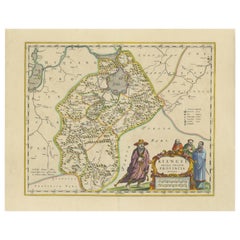
Description: This detailed 17th-century map of Jiangxi Province, historically referred to as "Kiangsi," was created by Johannes Blaeu and published in 1655 as part of the *Novus Atlas Sinensis*. Jiangxi, located in southeastern China, is known for its cultural heritage, scenic landscapes, and significant contributions to Chinese history.
The map meticulously charts Jiangxi’s geography, including mountain ranges, rivers, and cities, with place names rendered in Latin. Poyang Lake, one of the largest freshwater lakes in China, is prominently depicted, emphasizing the region’s ecological and economic importance. The map also highlights key cities such as Nanchang, the provincial capital, which has long been a cultural and political center, and Jingdezhen, globally famous as the center of Chinese porcelain production.
The decorative cartouche in the lower-right corner features traditional Chinese figures, adding cultural depth to the map. Blaeu’s craftsmanship is evident in the precise copperplate engraving and the vibrant hand-coloring, which enhances the boundaries and natural features, making this map both a functional document and a work of art.
Condition: Nearly excellent. Sharp impression with vivid hand-coloring. Wide margins with minor age-toning appropriate for its age.
Framing Tips: Use a neutral double mat and an ornate gilt or dark wood frame to highlight the map’s historical and artistic value. UV-protective glass is recommended to preserve the hand-coloring and intricate details.
Jiangxi, historically referred to as "Kiangsi," is famous for its rich cultural history, stunning landscapes, and economic contributions. It has been a key region for porcelain production, with Jingdezhen renowned as the "Porcelain Capital" of the world. Poyang Lake, featured prominently on the map, is vital for fishing, transportation, and its ecological significance. The province’s location along the Gan River has historically made it an important transportation corridor. Nanchang, the provincial capital, is noted for its historical landmarks and political significance in modern Chinese history.
Keywords include: antique map of Jiangxi, Kiangsi map, Poyang Lake, Jingdezhen porcelain, 17th-century China map...
Category
Antique 1650s Maps
Materials
Paper
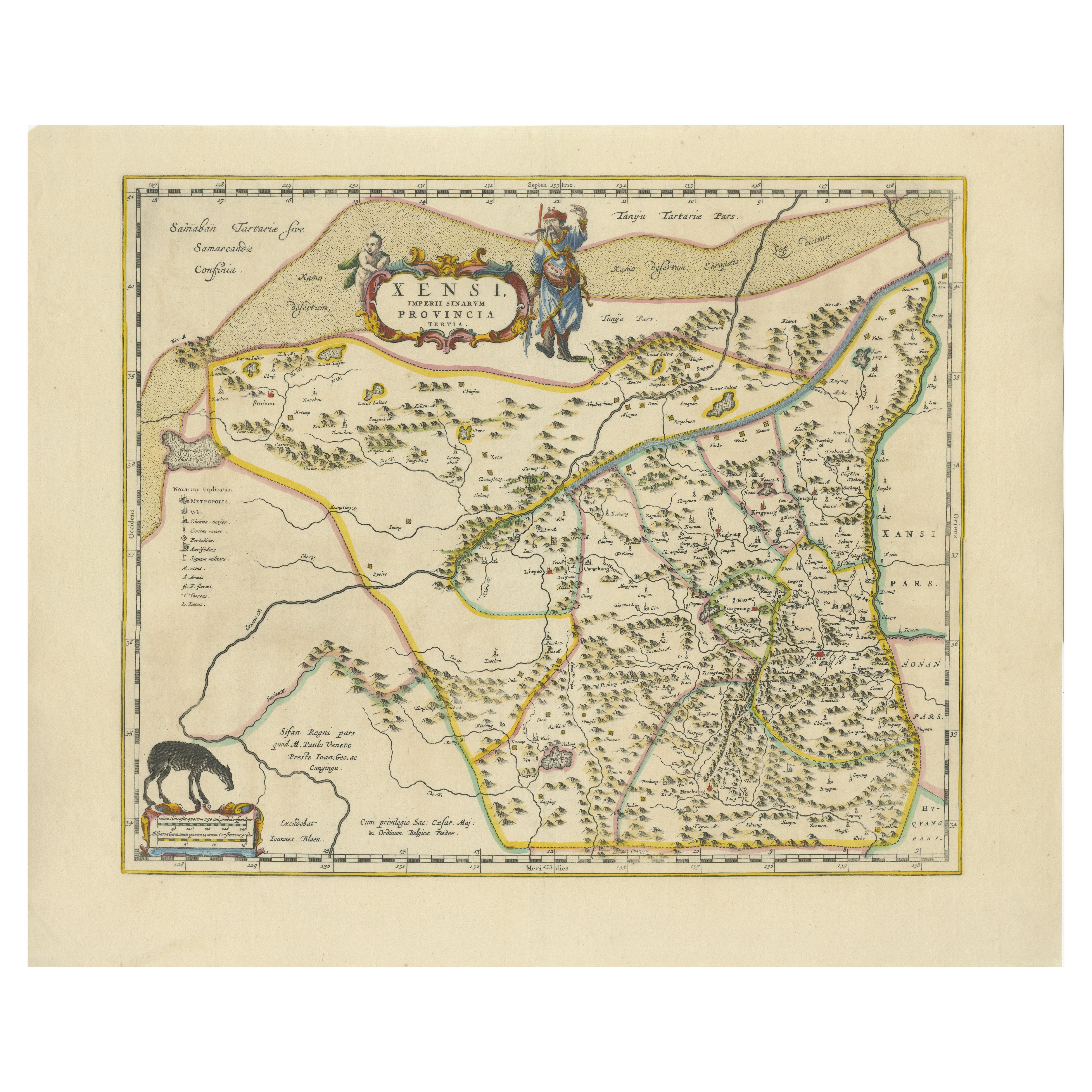
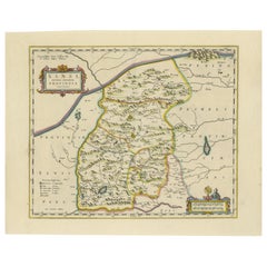
Original Antique 17th-Century Map of Shaangxi (Xensi) Province, China – by Blaeu
Located in Langweer, NL
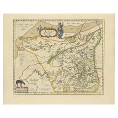
Antique 17th-Century Map of Shaangxi Province, China – "Xensi" by Blaeu, Featuring Decorative Cartouches
Description: This exquisite 17th-century map of Shaangxi Province, historically known as Xensi Province, is an exceptional work by Johannes Blaeu, one of the most celebrated mapmakers of the Dutch Golden Age. Originally published in Blaeu's groundbreaking 'Novus Atlas Sinensis', this map is a masterful blend of geography and artistry. Blaeu's atlas was created in collaboration with Martino Martini, a Jesuit missionary whose insights into China provided European audiences with unprecedented geographical accuracy.
The map meticulously charts Shaangxi's mountains, rivers, mines, cities, and towns, with names rendered in Latin. It also features a detailed section of the Great Wall of China, a symbol of the region's historical significance. The artistry of this map is further enhanced by its elaborate cartouches. At the top, a Chinese warrior is beautifully illustrated, while the lower-left corner displays a deer, possibly a reference to the elusive Pere David deer...
Category
Antique 1650s Maps
Materials
Paper
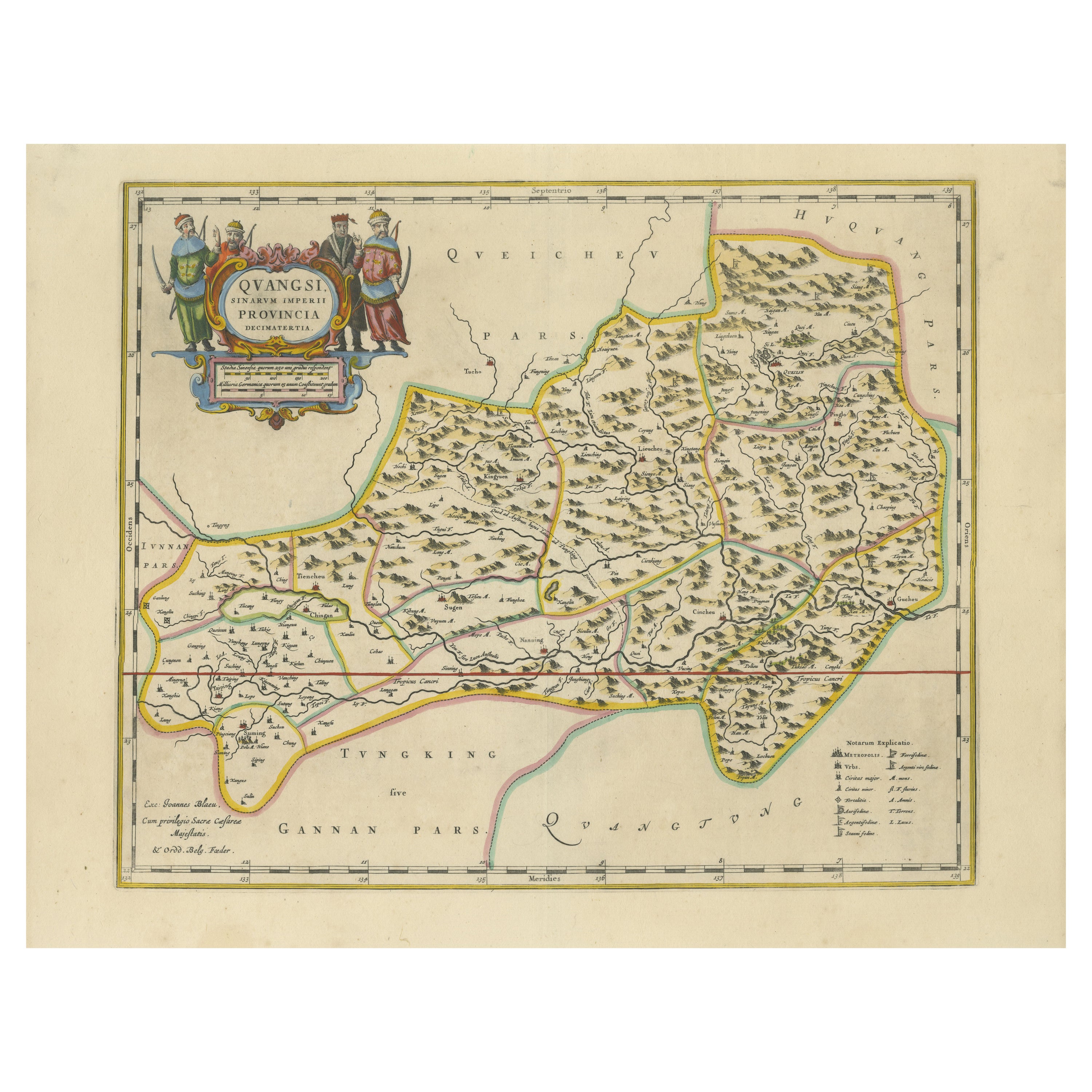
17th-Century Original Antique Map of Guangxi Province, China – Qvangsii by Blaeu
Located in Langweer, NL
Title: Antique 17th-Century Map of Guangxi Province, China – "Qvangsii" by Blaeu, Richly Illustrated and Colored
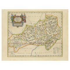
Description: This fascinating 17th-century map of Guangxi Province, historically referred to as "Qvangsii," was crafted by Johannes Blaeu and published in 1655 as part of the *Novus Atlas Sinensis*. Blaeu’s atlas, created in collaboration with Jesuit missionary Martino Martini, introduced European audiences to the geography of China in an unprecedented way. Guangxi Province, known for its striking karst landscapes and important historical trade routes, is depicted here in remarkable detail.
The map highlights the province’s topography, including mountain ranges, rivers, and towns, all meticulously engraved and labeled in Latin. It also captures key trade connections and cultural significance, as Guangxi historically served as a bridge between China and Southeast Asia. The decorative cartouche at the top left is adorned with figures in traditional Chinese costumes, symbolizing the cultural richness of the region and adding artistic elegance to the map.
This map was engraved using the copperplate technique, known for its ability to produce fine, detailed lines. The hand-coloring further enhances the visual impact, clearly distinguishing territorial divisions and natural features. Blaeu’s reputation for both accuracy and artistry is evident in this piece, making it a collector’s item of historical and aesthetic significance.
Guangxi Province, historically referred to as "Qvangsii," is renowned for its breathtaking natural beauty, unique karst landscapes, and cultural diversity. It is famous for its dramatic limestone formations, verdant hills, and picturesque rivers, making it one of the most visually striking regions in China. Guangxi has historically been a significant trade corridor between China and Southeast Asia, contributing to its cultural and economic importance. It is also home to various ethnic minority groups, including the Zhuang, Miao, and Dong, whose traditions and festivals enrich the region's cultural tapestry.
Important places in Guangxi include Guilin, known for its iconic karst mountains and the Li River, which has inspired poets and artists for centuries. Yangshuo, a town near Guilin, is celebrated for its stunning natural scenery and outdoor activities. Nanning, the provincial capital, is an important economic and cultural hub. The Longji Rice Terraces, also known as the Dragon’s Backbone, are an engineering marvel and a popular tourist destination. Beihai, a coastal city, is known for its silver beaches and maritime trade history.
Keywords for this map include 17th-century China map, Guangxi Province, Qvangsii map, antique Chinese maps...
Category
Antique 1650s Maps
Materials
Paper
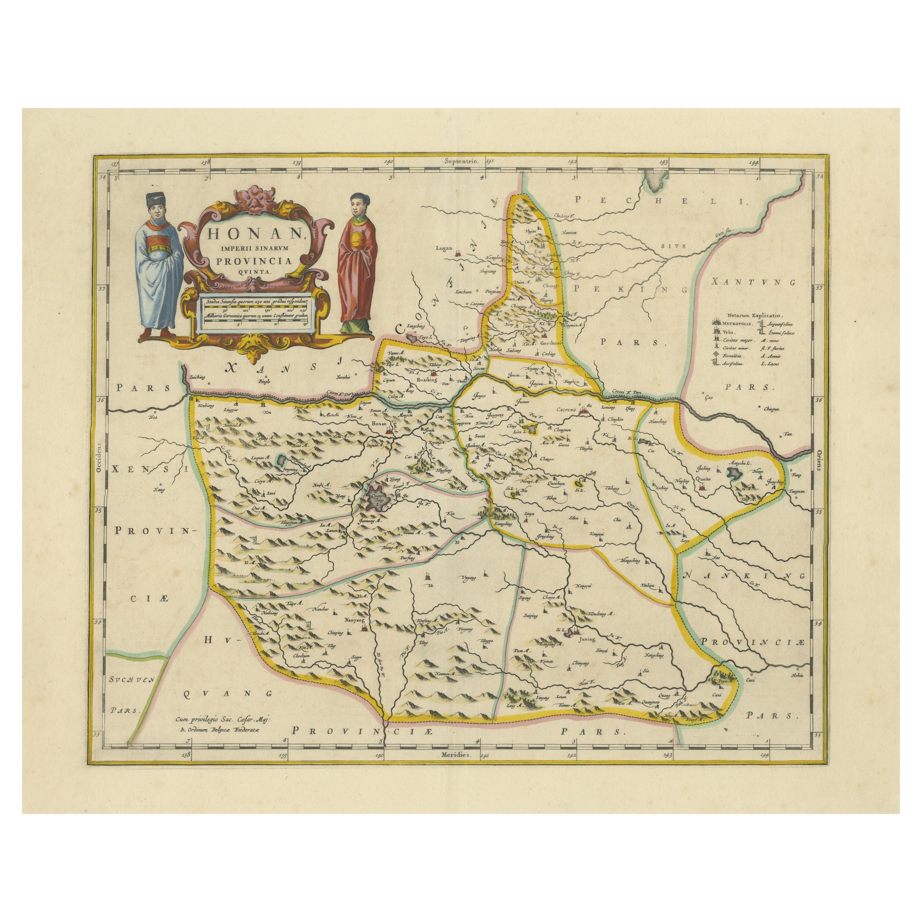
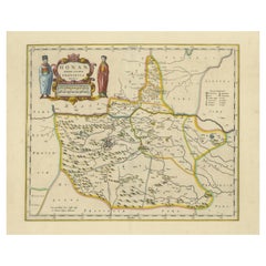
Original 17th-Century Antique Map of Henan (Honan) Province, China – by Blaeu
Located in Langweer, NL
17th-Century Antique Map of Henan Province, China – "Honan" by Blaeu, with Detailed Cartography and Artistic Cartouches
Description: This exceptional 17th-century map of Henan Province, historically referred to as "Honan," was created by Johannes Blaeu and published in 1655 as part of the *Novus Atlas Sinensis*. Henan, located in central China, is known as the cradle of Chinese...
Category
Antique 1650s Maps
Materials
Paper
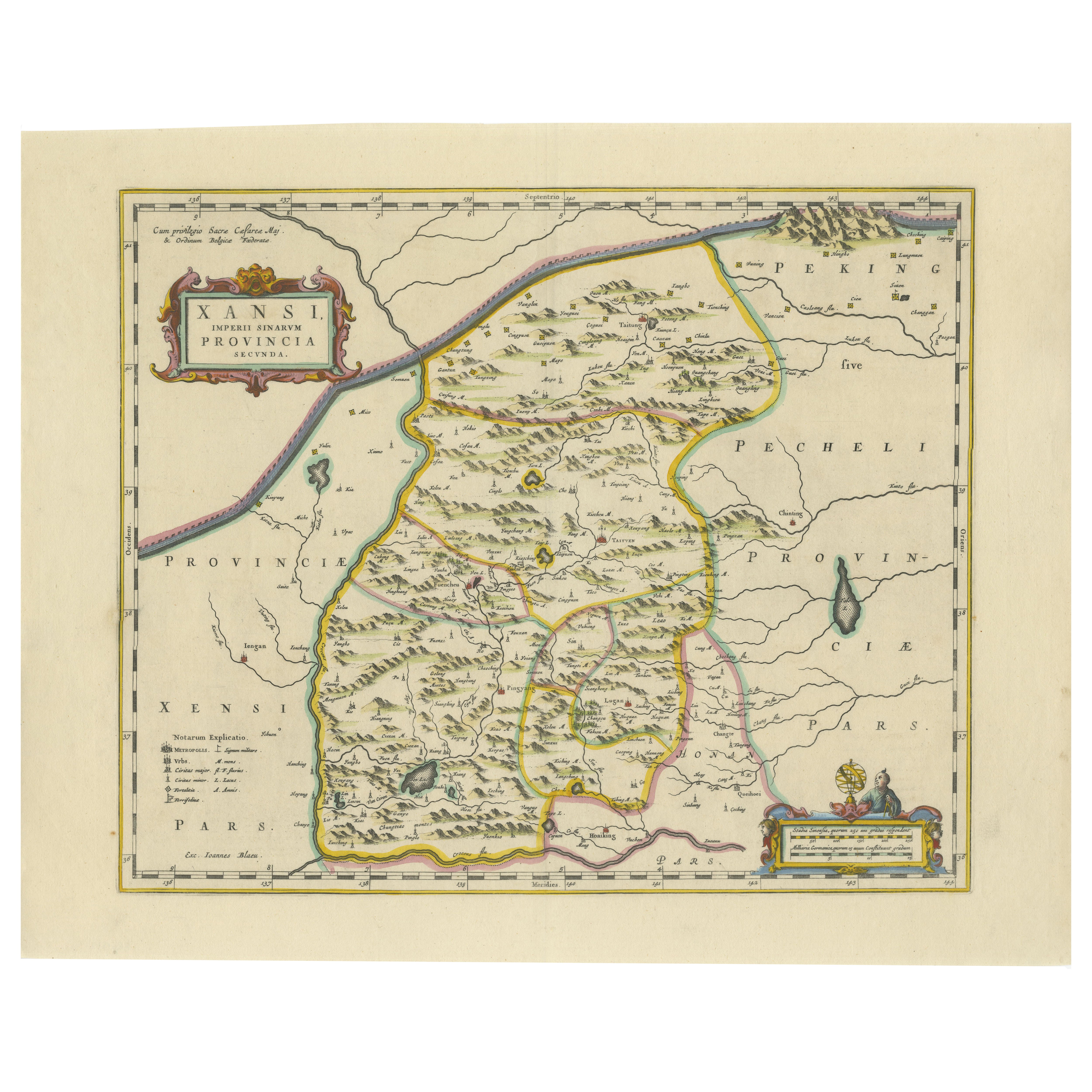
Original Antique 17th-Century Map of Shanxi (Xansi) Province, China – by Blaeu
Located in Langweer, NL
Antique 17th-Century Map of Shanxi Province, China – "Xansi" by Blaeu, with Artistic Cartouches
Description: This beautifully engraved map of Shanxi Province, historically referred to as "Xansi," was created by Johannes Blaeu in 1655 as part of his renowned *Novus Atlas Sinensis*. This atlas was the first comprehensive Western collection focused on Chinese geography, produced with the guidance of Jesuit missionary Martino Martini. Blaeu’s attention to detail and artistic flair are evident in this representation of Shanxi, highlighting mountains, rivers, cities, towns, and key geographic features. The Great Wall of China, an iconic landmark, is also depicted.
The map includes decorative cartouches that enhance its aesthetic appeal. The upper-left corner features the map's title framed in an ornate design, while the lower-right corner showcases a seated figure in traditional Chinese attire alongside a small globe, symbolizing the merging of European cartographic expertise and Chinese knowledge. Each city and geographic feature is labeled in Latin, making it a fascinating historical artifact of cross-cultural exploration.
This map was crafted using the copperplate engraving technique, prized for its ability to produce fine, precise details. It is further embellished with hand-coloring, which brings the landscape and decorative elements to life. Blaeu’s maps are highly regarded for their accuracy, artistry, and historical significance, making this piece a valuable collectible.
Shanxi Province, historically referred to as "Xansi," is renowned for its historical significance, natural landscapes, and rich cultural heritage. The region has been a crucial center of Chinese history and culture for centuries. Its name, meaning "West of the Mountains," refers to its location west of the Taihang Mountains. Shanxi has long been known for its coal resources, which have made it an important economic hub in modern times.
Important places in Shanxi include Pingyao, a UNESCO World Heritage Site known for its well-preserved ancient city walls and traditional Chinese architecture. The Yungang Grottoes, near Datong, are another UNESCO site, famous for their intricate Buddhist carvings and statues. Mount Wutai, one of China’s Four Sacred Buddhist Mountains, is a significant religious site that attracts pilgrims and tourists alike. Taiyuan, the provincial capital, is known for its historical sites, including the Jinci Temple. Shanxi is also known for its role in the early development of Chinese banking, particularly during the Ming and Qing Dynasties.
Keywords include antique map of Shanxi, Xansi map, Pingyao, Yungang Grottoes, Mount Wutai, 17th-century China map...
Category
Antique 1650s Maps
Materials
Paper
You May Also Like
17th Century John Speed Map of Denbighshire, c.1610
By John Speed
Located in Royal Tunbridge Wells, Kent
Antique early 17th century British very rare and original John Speed, hand coloured map of Denbighshire, dated 1610, by John Sunbury and George Humble. John...
Category
Antique 17th Century British Maps
Materials
Wood, Paper

17th Century Nicolas Visscher Map of Southeastern Europe
Located in Hamilton, Ontario
A beautiful, highly detailed map of southeastern Europe by Nicolas Visscher. Includes regions of Northern Italy (showing the cities Bologna, Padua, and Venice), Bohemia, Austria (sho...
Category
Antique 17th Century Dutch Maps
Materials
Paper

$1,350 Sale Price
38% Off
"Africa Vetus": a 17th Century Hand-Colored Map by Sanson
By Nicolas Sanson
Located in Alamo, CA
This original hand-colored copperplate engraved map of Africa entitled "Africa Vetus, Nicolai Sanson Christianiss Galliar Regis Geographi" was originally created by Nicholas Sanson d...
Category
Antique Late 17th Century French Maps
Materials
Paper

Northern Scotland: A 17th Century Hand-colored Map by Mercator
By Gerard Mercator
Located in Alamo, CA
This is a framed hand-colored 17th century map of Northern Scotland by Gerard Mercator entitled "Scotiae pars Septentrionalis", published in Amsterdam in 1636. It is a highly detailed map of the northern part of Scotland, with the northwest Highlands and the cities Inverness and Aberdeen, as well as the Orkney Islands and the Hebrides. There is a decorative title cartouche in the upper left corner.
The map is presented in an antiqued brown wood...
Category
Antique 1630s Dutch Maps
Materials
Paper

17th Century Map of Denmark by French Cartographer Sanson, Dated 1658
By Nicolas Sanson
Located in Copenhagen, K
17th century map of Denmark by French cartographer Sanson.
Nicolas Sanson (20 December 1600-7 July 1667) was a French cartographer, termed by some the creator of French geography an...
Category
Antique 17th Century French Maps
Materials
Paper

17th Century John Speed Map of the Barkshire Described, c.1616
By John Speed
Located in Royal Tunbridge Wells, Kent
Antique 17th century British very rare and original John Speed (1551-1629) map of the Barkshire Described, J. Sud and Georg Humble, publication (1616 or lat...
Category
Antique 17th Century British Maps
Materials
Paper

Recently Viewed
View AllMore Ways To Browse
Hand Colored Engravings Of European Cities
Martini Waller
Chinese Waterfall
Blaeu Wall Map
Chinese Minority
Chinese Communist
Green Martini Glasses
French Coffee Bowl
French Salon Sofa
Fruit Knife
Furniture By Donghia
Genuine Sheepskin
German Colored Crystal Glass
Gilt Wall Sculpture Large
Glass Berry Bowl
Glass Mosaic Tile Wall Art
Hammock Designs
Hand Blown Glass Tumbler