Items Similar to Old Map of the Western Region of the Kingdom of Algiers, Algeria, 1773

Want more images or videos?
Request additional images or videos from the seller
1 of 5
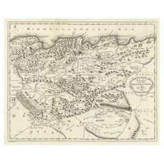
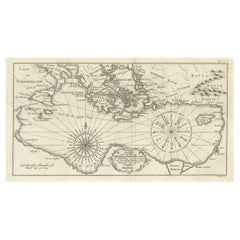
Old Map of the Western Region of the Kingdom of Algiers, Algeria, 1773
About the Item
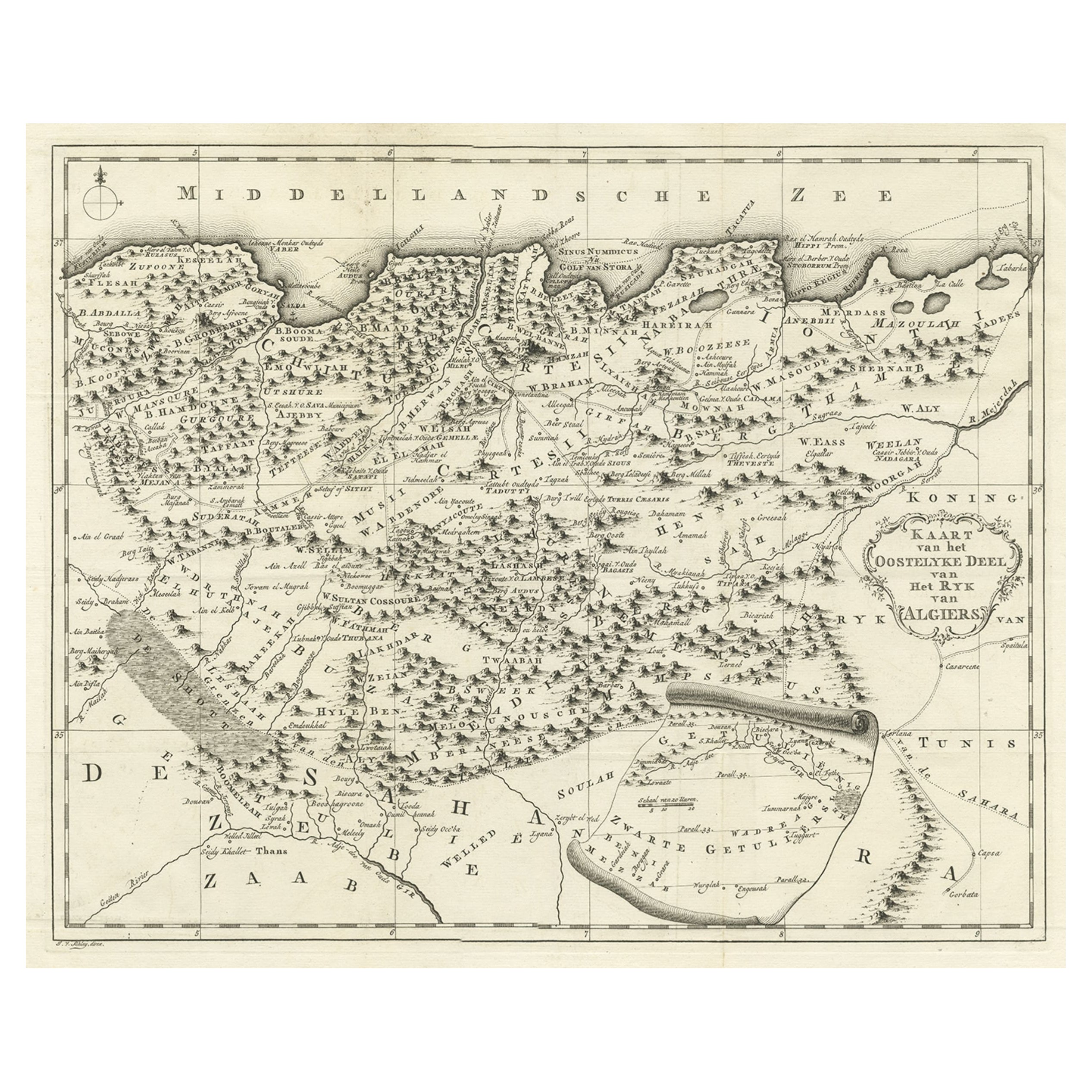
Antique map titled 'Kaart van het Westelyk Gedeelte van het Ryk van Algiers'.
Old map of the western region of the Kingdom of Algiers, Algeria. Originates from the first Dutch editon of an interesting travel account of Northern Africa titled 'Reizen en Aanmerkingen door en over Barbaryen en het Ooste'.
Artists and Engravers: Author: T. Shaw. Translated by P. Boddaert and published by J. van Schoonhoven.
- Dimensions:Height: 14.38 in (36.5 cm)Width: 19.1 in (48.5 cm)Depth: 0 in (0.02 mm)
- Materials and Techniques:
- Period:1770-1779
- Date of Manufacture:1773
- Condition:Wear consistent with age and use. Condition: Good, general age-related toning. Repair right margin, please study image carefully.
- Seller Location:Langweer, NL
- Reference Number:Seller: BG-11797-30 1stDibs: LU3054327206532
About the Seller
5.0
Recognized Seller
These prestigious sellers are industry leaders and represent the highest echelon for item quality and design.
Platinum Seller
Premium sellers with a 4.7+ rating and 24-hour response times
Established in 2009
1stDibs seller since 2017
2,412 sales on 1stDibs
Typical response time: 1 hour
- ShippingRetrieving quote...Shipping from: Langweer, Netherlands
- Return Policy
Authenticity Guarantee
In the unlikely event there’s an issue with an item’s authenticity, contact us within 1 year for a full refund. DetailsMoney-Back Guarantee
If your item is not as described, is damaged in transit, or does not arrive, contact us within 7 days for a full refund. Details24-Hour Cancellation
You have a 24-hour grace period in which to reconsider your purchase, with no questions asked.Vetted Professional Sellers
Our world-class sellers must adhere to strict standards for service and quality, maintaining the integrity of our listings.Price-Match Guarantee
If you find that a seller listed the same item for a lower price elsewhere, we’ll match it.Trusted Global Delivery
Our best-in-class carrier network provides specialized shipping options worldwide, including custom delivery.More From This Seller
View AllOld Map of the Eastern Region of the Kingdom of Algiers, Algeria, 1773
Located in Langweer, NL
Antique map titled 'Kaart van het Oostelyke Deel van het Ryk van Algiers'.
Old map of the eastern region of the Kingdom of Algiers, Algeria. Originates from the first Dutch edito...
Category
Antique 1770s Maps
Materials
Paper
$425 Sale Price
20% Off
Detailed Original Old Map of the Southern Region of the Kingdom of Algiers 1773
Located in Langweer, NL
Antique map titled 'Kaart van het Zuidelyk Gedeelte van het Ryk Algiers'.
Old map of the southern region of the Kingdom of Algiers, Algeria. Originates from the first Dutch edito...
Category
Antique 18th Century Maps
Materials
Paper

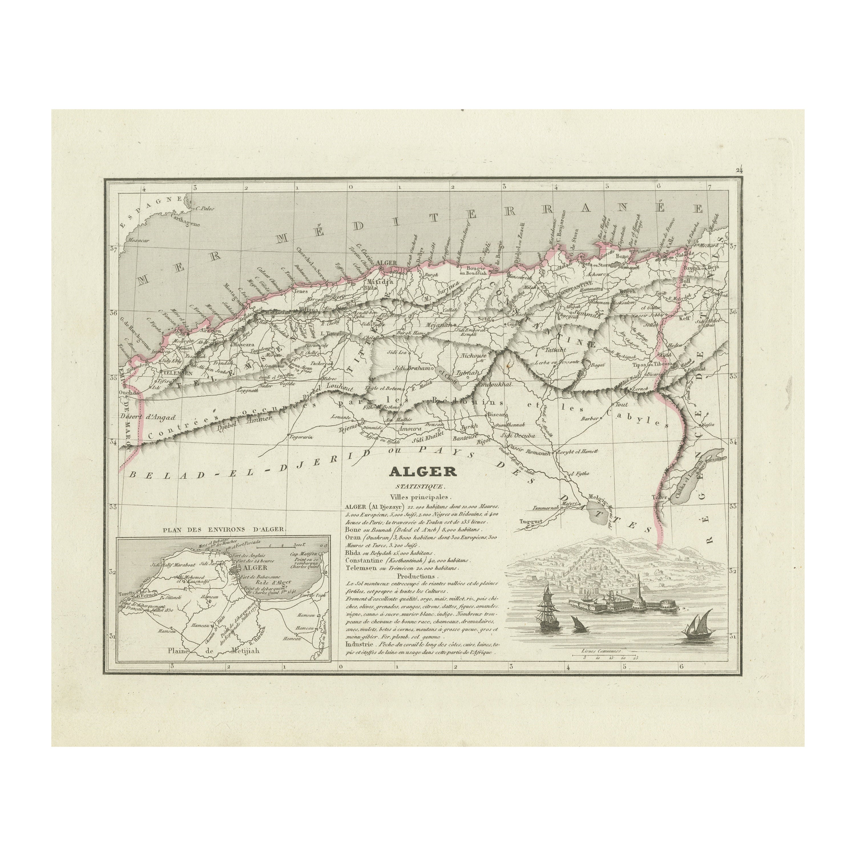
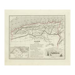
Antique Map of the Region of Algiers, Algeria
Located in Langweer, NL
Antique map titled 'Alger'. This map shows the region of Algiers, Algeria. With a small inset map of the region of Algiers and a decorative vignette with a harbor view. Originates fr...
Category
Antique Mid-19th Century Maps
Materials
Paper
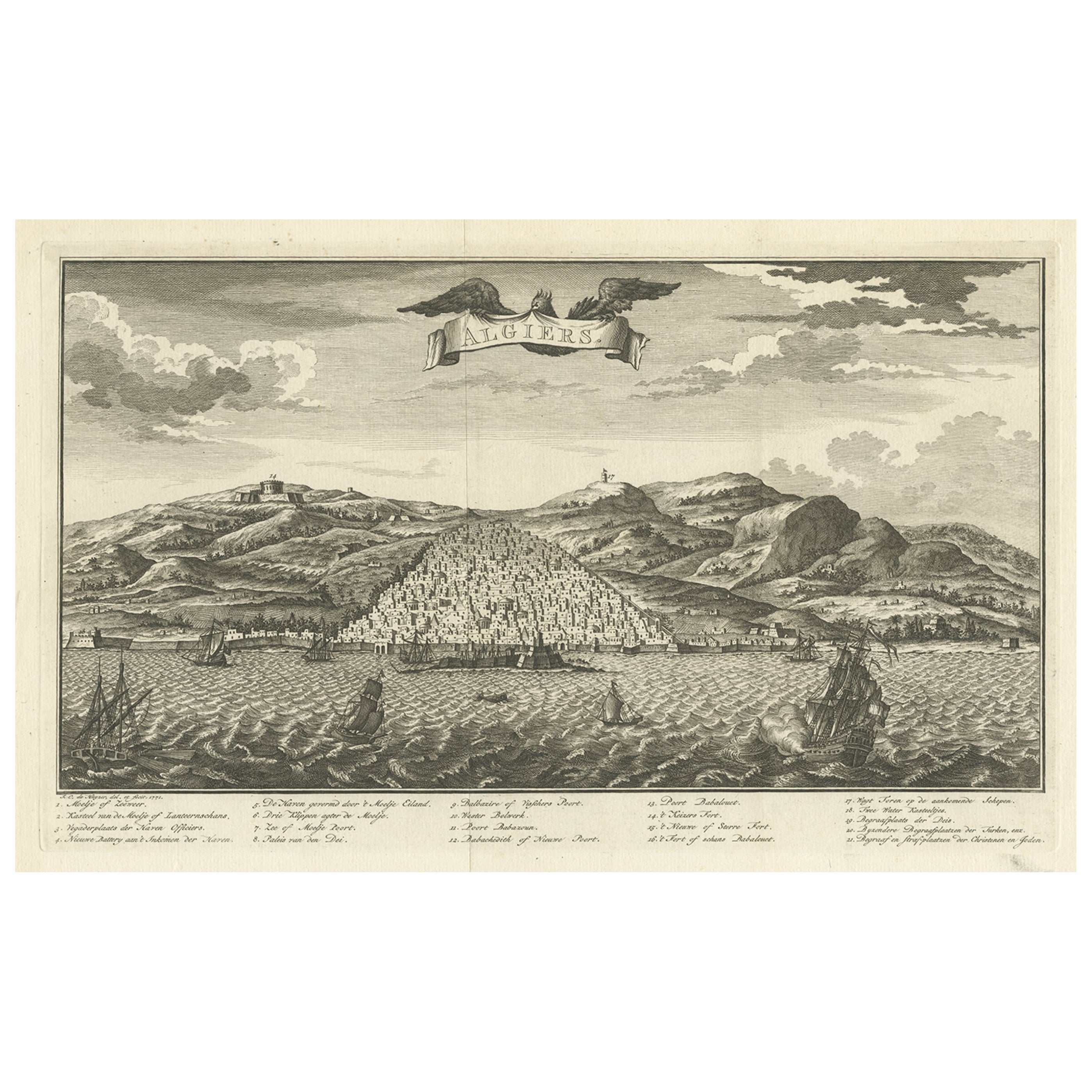
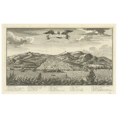
Original Antique Engraving of Algiers in Algeria, 1773
Located in Langweer, NL
Antique print titled 'Algiers'. Old print with a view of Algiers, Algeria. With Dutch legend. Originates from the first Dutch editon of an interesting travel account of Northern Afri...
Category
Antique 18th Century Prints
Materials
Paper
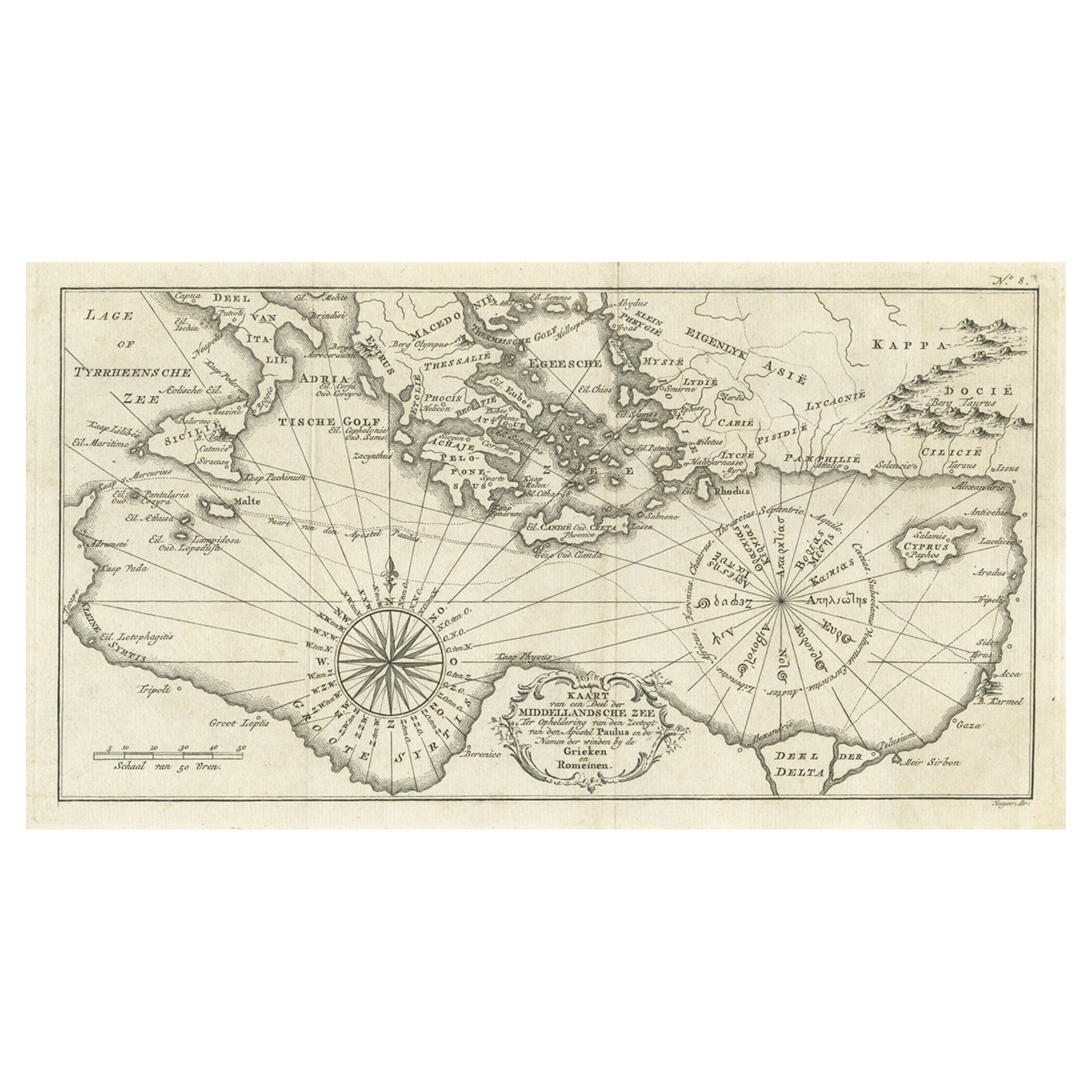
Old Dutch Map of the Region Around the Mediterranean Sea, 1773
Located in Langweer, NL
Antique map titled 'Kaart van een Deel der Middelandsche Zee (..)'.
Old map of the region around the Mediterranean Sea. Originates from the first Dutch editon of an interesting t...
Category
Antique 1770s Maps
Materials
Paper
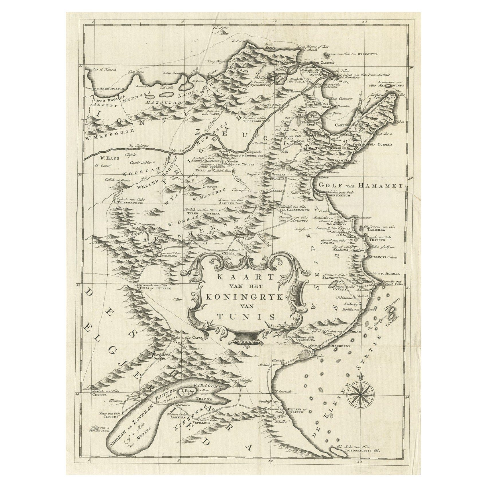
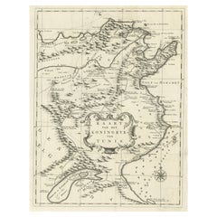
Antique Map of the Kingdom of Tunisia, Africa, 1773
Located in Langweer, NL
Antique map titled 'Kaart van het Koningryk van Tunis'. Old map of the Kingdom of Tunisia. Originates from the first Dutch editon of an interesting travel account of Northern Africa ...
Category
Antique 18th Century Maps
Materials
Paper
You May Also Like
Old Horizontal Map of England
By Tasso
Located in Alessandria, Piemonte
ST/520 - Old rare Italian map of England, dated 1826-1827 - by Girolamo Tasso, editor in Venise, for the atlas of M.r Le-Sage.
Category
Antique Early 19th Century Italian Other Prints
Materials
Paper

The Kingdom of Naples and Southern Italy: A Hand-Colored 18th Century Homann Map
By Johann Baptist Homann
Located in Alamo, CA
"Novissima & exactissimus Totius Regni Neapolis Tabula Presentis Belli Satui Accommo Data" is a hand colored map of southern Italy and the ancient Kingdom of Naples created by Johann...
Category
Antique Early 18th Century German Maps
Materials
Paper

17th Century Hand Colored Map of the Liege Region in Belgium by Visscher
By Nicolaes Visscher II
Located in Alamo, CA
An original 17th century map entitled "Leodiensis Episcopatus in omnes Subjacentes Provincias distincté divisusVisscher, Leodiensis Episcopatus" by Nicolaes Visscher II, published in Amsterdam in 1688. The map is centered on Liege, Belgium, includes the area between Antwerp, Turnhout, Roermond, Cologne, Trier and Dinant.
This attractive map is presented in a cream-colored mat measuring 30" wide x 27.5" high. There is a central fold, as issued. There is minimal spotting in the upper margin and a tiny spot in the right lower margin, which are under the mat. The map is otherwise in excellent condition.
The Visscher family were one of the great cartographic families of the 17th century. Begun by Claes Jansz Visscher...
Category
Antique Late 17th Century Dutch Maps
Materials
Paper

The Normandy Region of France: A 17th C. Hand-colored Map by Sanson and Jaillot
By Nicolas Sanson
Located in Alamo, CA
This large hand-colored map entitled "Le Duché et Gouvernement de Normandie divisée en Haute et Basse Normandie en divers Pays; et par evêchez, avec le Gouvernement General du Havre ...
Category
Antique 1690s French Maps
Materials
Paper

Map of the Republic of Genoa
Located in New York, NY
Framed antique hand-coloured map of the Republic of Genoa including the duchies of Mantua, Modena, and Parma.
Europe, late 18th century.
Dimension: 25...
Category
Antique Late 18th Century European Maps

17th Century Hand-Colored Map of a Region in West Germany by Janssonius
By Johannes Janssonius
Located in Alamo, CA
This attractive highly detailed 17th century original hand-colored map is entitled "Archiepiscopatus Maghdeburgensis et Anhaltinus Ducatus cum terris adjacentibus". It was published ...
Category
Antique Mid-17th Century Dutch Maps
Materials
Paper

Recently Viewed
View AllMore Ways To Browse
Antique African Door
Wing Arm Chair
Winged Arm Chair
Winged Back Chair Pair
18th Century Painted Italian Console Tables
1890 Serapi
3x5 Wool Rug Pink
4 Leather Game Table Chairs
Antique Bathroom Vanity Table
Antique Mahogany Settee
Antique Ships In Bottles
Antique Velvet Upholstery Fabric
Antique Yellow Wood Table
Armchair White Linen
Aubusson Cover
Ball Lock
Black And Silver Murano Vase
Brass Tray Cocktail Table