Items Similar to Mapping History: The Decorative Cartography of Indre-et-Loire by Levasseur, 1856

Want more images or videos?
Request additional images or videos from the seller
1 of 9
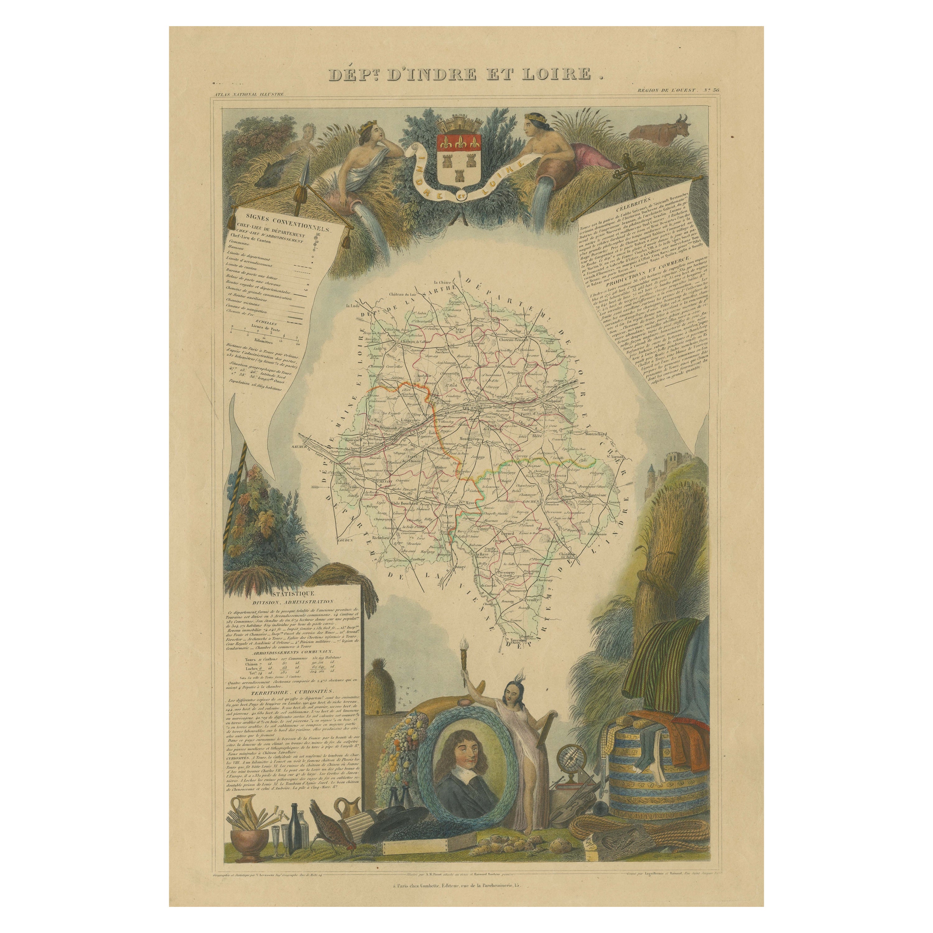
Mapping History: The Decorative Cartography of Indre-et-Loire by Levasseur, 1856
About the Item
An original hand-colored map of the Département d'Indre-et-Loire created by Victor Levasseur in 1856. As an antique steel engraved map, it showcases the detailed craftsmanship and technology of mid-19th century map making. The method of steel engraving allowed for precise and intricate details to be captured, making this map not only a navigational tool but also a work of art.
The addition of outline hand colouring is particularly noteworthy. This technique, where colours are applied by hand to the engraved map, was a common practice at the time to highlight certain features such as boundaries, rivers, and cities. The hand colouring on this map would have been done meticulously, adding vibrancy and clarity to the engraved lines and making it easier to differentiate various geographical and political demarcations.
The map's wide margins are characteristic of the period's presentation style, offering space for additional annotations or simply serving to frame the map aesthetically when displayed. Such margins also suggest that the map was intended for a discerning audience, possibly for educational or decorative purposes in a library or study.
Victor Levasseur was renowned for his decorative maps, often embellished with artistic elements that went beyond mere geographical information. These elements could include vignettes, allegorical figures, and detailed illustrations surrounding the map itself, reflecting the cultural, historical, and economic aspects of the depicted area. While the description does not detail these decorative aspects, it's common for Levasseur's works to feature such embellishments, making his maps highly prized among collectors and historians for both their artistic value and cartographic accuracy.
This map of Département d'Indre-et-Loire, with its combination of technical precision in steel engraving and the beauty of hand colouring, represents a fascinating intersection of art and science in the 19th century. It is a testament to the era's dedication to detail, craftsmanship, and the aesthetic presentation of information.
The Département d'Indre-et-Loire, located in the central part of France within the region known as the Centre-Val de Loire, is rich in historical and cultural significance, with numerous important places highlighted on a map from 1856 by Victor Levasseur. Based on the region's known historical sites and cities, the following places are likely to be featured or of importance:
1. **Tours**: As the capital city of the Département d'Indre-et-Loire, Tours is a central hub of history, culture, and architecture. It is known for its old town, the Place Plumereau, Tours Cathedral, and its proximity to the Loire River, making it a likely focal point on the map.
2. **Amboise**: This town is famous for the Château d'Amboise, which is closely linked to French royal history and offers panoramic views of the Loire River. Leonardo da Vinci is buried here in the Chapel of Saint-Hubert, associated with the château.
3. **Chinon**: Known for its medieval fortress, the Château de Chinon, this town has deep historical roots, including connections to Joan of Arc and King Charles VII. The fortress and town would be significant landmarks.
4. **Villandry**: The Château de Villandry is renowned for its beautiful Renaissance gardens, which are some of the most impressive in France. While the château might be less emphasized in an 1856 map compared to cities and towns, it's an important site in the region.
5. **Loches**: This town features the Château de Loches, a medieval castle, and the Royal Lodge, noted for its Renaissance architecture. The town's history and architectural landmarks make it a place of interest.
6. **Azay-le-Rideau**: The Château d'Azay-le-Rideau is set on an island in the middle of the Indre River, showcasing the French Renaissance architectural style. It's one of the earliest French Renaissance châteaux and a jewel of architectural beauty.
7. **Langeais**: Known for the Château de Langeais, a castle that presents a mix of medieval and Renaissance elements. The château plays a significant role in French history, including the marriage of Charles VIII and Anne of Brittany.
These locations, along with the river systems, particularly the Loire and Indre rivers, vineyards, and the rich agricultural landscapes, would be among the key features likely highlighted on Levasseur's map. Maps from this period often emphasized both the natural geography and the human settlements and landmarks that defined a region.
- Dimensions:Height: 20.67 in (52.5 cm)Width: 14.34 in (36.4 cm)Depth: 0 in (0.02 mm)
- Materials and Techniques:
- Period:
- Date of Manufacture:1856
- Condition:Good. Central folding line or split professionally restored. Minor soiling around the edges. The image clean and decorative. Study the images carefully.
- Seller Location:Langweer, NL
- Reference Number:Seller: BG-13703-71stDibs: LU3054338247682
About the Seller
5.0
Recognized Seller
These prestigious sellers are industry leaders and represent the highest echelon for item quality and design.
Platinum Seller
Premium sellers with a 4.7+ rating and 24-hour response times
Established in 2009
1stDibs seller since 2017
2,417 sales on 1stDibs
Typical response time: <1 hour
- ShippingRetrieving quote...Shipping from: Langweer, Netherlands
- Return Policy
Authenticity Guarantee
In the unlikely event there’s an issue with an item’s authenticity, contact us within 1 year for a full refund. DetailsMoney-Back Guarantee
If your item is not as described, is damaged in transit, or does not arrive, contact us within 7 days for a full refund. Details24-Hour Cancellation
You have a 24-hour grace period in which to reconsider your purchase, with no questions asked.Vetted Professional Sellers
Our world-class sellers must adhere to strict standards for service and quality, maintaining the integrity of our listings.Price-Match Guarantee
If you find that a seller listed the same item for a lower price elsewhere, we’ll match it.Trusted Global Delivery
Our best-in-class carrier network provides specialized shipping options worldwide, including custom delivery.More From This Seller
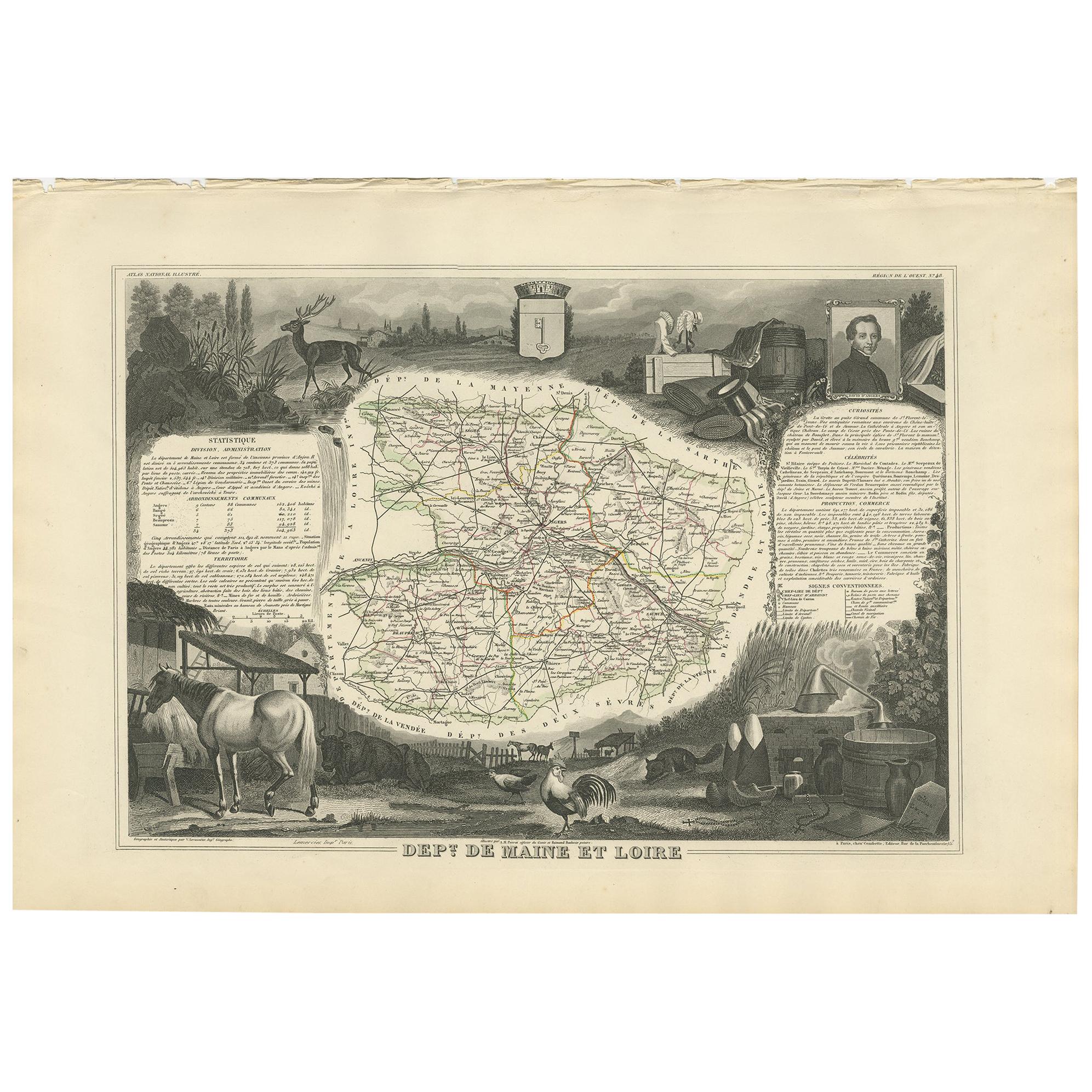
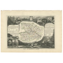
View AllAntique Map of Maine et Loire ‘France’ by V. Levasseur, 1854
Located in Langweer, NL
Antique map titled 'Dépt. de Maine et Loire'. Map of the French department of Maine et Loire, France. This area of France is part of the Loire Valley wine region, where nearly every ...
Category
Antique Mid-19th Century Maps
Materials
Paper
$167 Sale Price
20% Off
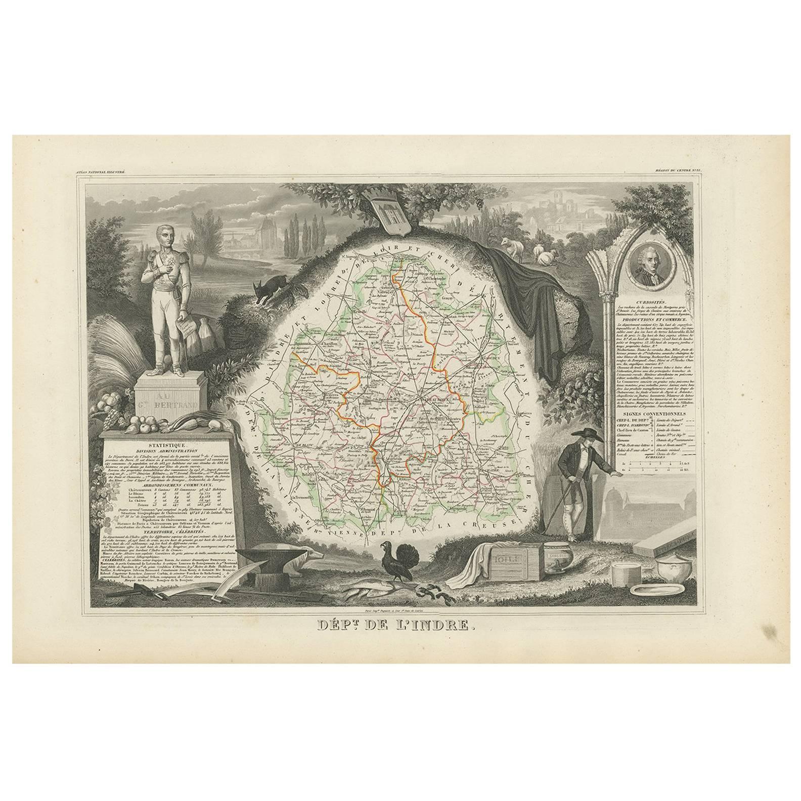
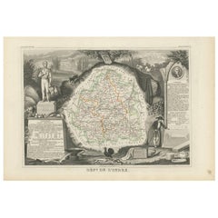
Antique Map of Indre ‘France’ by V. Levasseur, 1854
Located in Langweer, NL
Antique map titled 'Dépt. de l'Indre'. Map of the French department of Indre, France. Part of the Loire Valley wine region, this area is known for its production of Chinon wines, typ...
Category
Antique Mid-19th Century Maps
Materials
Paper
$167 Sale Price
20% Off
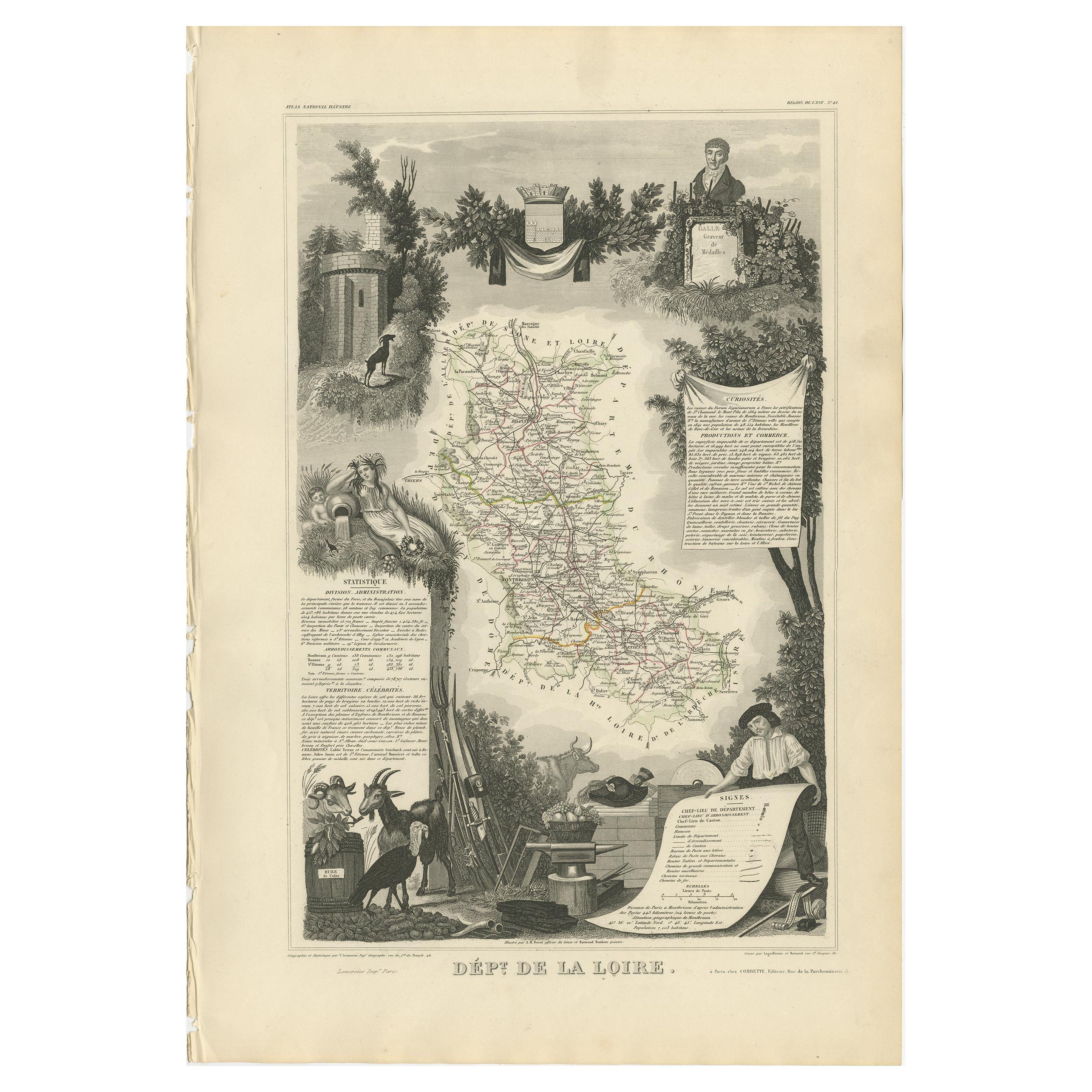
Antique Map of Loire ‘France’ by V. Levasseur, 1854
Located in Langweer, NL
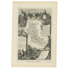
Antique map titled 'Dépt. de la Loire'. Map of the French department of Loire, France. This area of France is part of the Loire Valley wine growing region...
Category
Antique Mid-19th Century Maps
Materials
Paper
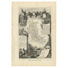
Antique Map of Loire ‘France’ by V. Levasseur, 1854
Located in Langweer, NL
Antique map titled 'Dépt. de la Loire'. Map of the French department of Loire, France. This area of France is part of the Loire Valley wine growing region. The area includes 87 appel...
Category
Antique Mid-19th Century Maps
Materials
Paper
$104 Sale Price
40% Off
Hand Colored Antique Map of the department of Indre and Loire, France
By Victor Levasseur
Located in Langweer, NL
Antique map titled 'Dépt. d'Indre et Loire'. Map of the Department de L’Indre et Loire, France. This region is known for its fine wines, agriculture, distilled spirits, and cheese. T...
Category
Antique Mid-19th Century Maps
Materials
Paper

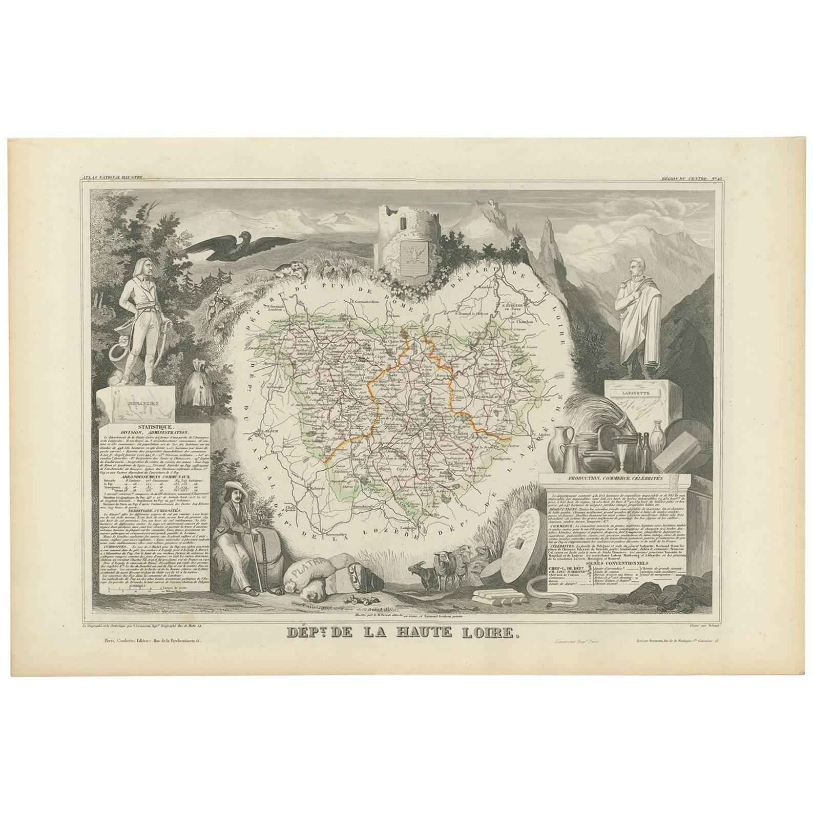
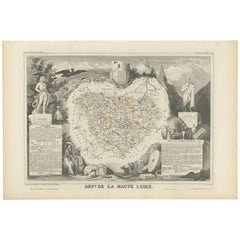
Antique Map of Haute Loire ‘France’ by V. Levasseur, 1854
Located in Langweer, NL
Antique map titled 'Dépt. de la Haute Loire'. Map of the French department of Haute Loire, France. This area of France is part of the Loire Valley wine gro...
Category
Antique Mid-19th Century Maps
Materials
Paper
You May Also Like
Fine Antique 1856 Hand Watercolour Map of Dept Des Hautes Alpes by Levasseur's
Located in West Sussex, Pulborough
We are delighted to offer for sale this stunning 1856 hand watercolour map of the Austrian Alps titled Dept Des Hautes Alpes taken from the Atlas National...
Category
Antique 1850s French Early Victorian Maps
Materials
Paper

$814 Sale Price
20% Off
Decorative Vintage Ironwork, a Pictorial History
Located in Bradenton, FL
Decorative Vintage Ironwork, A Pictorial History by Henry Rene D'Allemagne. Softcover book, 413 pages, published in 1968 by Dover Publications, Inc. o...
Category
Vintage 1960s Books
Materials
Paper
The History of Postmodern Architecture
Located in Richmond, VA
Hardback book titled The History of Postmodern Architecture, authored by Heinrich Klotz and translated by Radka Donnell. Published by MIT Press, Cambridge, 1988. First English editio...
Category
Vintage 1980s Books
Materials
Paper

The Natural History of Selbourne by Gilbert White
Located in Bradenton, FL
The Natural History of Selbourne by Gilbert White. A large hardcover book with top-edge gilt in a brown card slipcase. Published in 2009 by The Folio Society of London. Illustrated, ...
Category
21st Century and Contemporary English Books
Materials
Paper
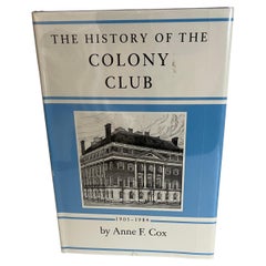
The History of the Colony Club by Ann F. Cox Book
Located in Stamford, CT
The History of the Colony Club by Ann F. Cox. Hardcover, 1st edition. 1984. Privately printed by the club.
The Colony Club is a women-only private social club in New York City.
Category
Vintage 1980s American Belle Époque Books
Materials
Paper
The History Of Tom Jones by Henry Fielding 1964
Located in North Hollywood, CA
The History Of Tom Jones By Henry Fielding
New York: Random House, 1964.
Slip Case.
Lawrence Beall Smith.
Copyright date is 1964, maroon and black cov...
Category
Mid-20th Century American Expressionist Books
Materials
Paper
Recently Viewed
View AllMore Ways To Browse
French Educational
French Chateau Engraving
19th Century Carpet Bag
3 Piece Sterling Silver Tea Set
48 Round Coffee Table
7 Foot Sofa
Antique Cherry Chair
Antique Mason Plates
Antique Measuring Jugs
Antique Red Trunk
Antique Table 4 Drawers
Antique Work Stool
Antique Yolk
Art Nouveau Silver Overlay
Axe Table
Ball And Claw Chippendale Chair
Baroque Writing Desk
Beautiful Ladies Paintings