Items Similar to Map of Soria Province, 1901: Detailed Cartography of Northeastern Spain
Want more images or videos?
Request additional images or videos from the seller
1 of 7
Map of Soria Province, 1901: Detailed Cartography of Northeastern Spain
About the Item
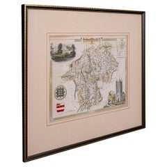
The map is a historical map of the province of Soria from 1901.
A decorative coat of arms enhances the aesthetic of the map, signifying the historical and cultural significance of Soria. The use of color is both functional and decorative, with blues likely representing water features, browns and greens for the land, and reds for main roads or boundaries.
Soria is a province located in the autonomous community of Castile and León in Spain. The map reflects the political and geographic understanding of the region at the beginning of the 20th century.
This map serves as both a navigational aid and a historical document, providing insights into the geography, infrastructure, and administrative organization of Soria at the time of its creation. The level of detail suggests it was designed for practical use, possibly by government officials or for civic planning.
Soria, a province in the autonomous community of Castile and León in Spain, is known for its rich historical heritage, natural beauty, and cultural significance. Traditionally, some of the main points of interest in the province of Soria would include:
1. **The City of Soria**: The provincial capital itself is a point of interest, with its historical architecture and cultural sites.
2. **Numancia**: An ancient Celtiberian settlement that is famous for its resistance against the Romans. The archaeological site near the village of Garray is a significant historical landmark.
3. **Monastery of San Juan de Duero**: An impressive monastery located on the banks of the river Duero, known for its unique cloister and mix of architectural styles.
4. **Hermitage of San Saturio**: Nestled into the side of a cliff and overlooking the river Duero, this hermitage is a peaceful retreat with beautiful frescoes.
5. **Plaza Mayor**: In the heart of Soria, the Plaza Mayor is a central spot for gatherings and is surrounded by important buildings.
6. **Iglesia de Santo Domingo**: A Romanesque church in Soria with a stunning façade, considered one of the best examples of Romanesque architecture in the province.
7. **Laguna Negra and the Urbión Glacial Lagoon**: A deep mountain lake surrounded by pine forests and steep cliffs, part of the natural park "Laguna Negra y Circos Glaciares de Urbión".
8. **Sierra de Cebollera Natural Park**: A mountainous area that offers numerous hiking trails and a variety of flora and fauna.
9. **The Río Lobos Canyon**: A striking natural canyon that provides a habitat for a variety of wildlife, as well as opportunities for hiking and exploration.
10. **Castillo de Gormaz**: One of the largest and longest fortresses in Europe, offering panoramic views of the surrounding countryside.
11. **El Burgo de Osma**: A historic town with a beautiful cathedral and a well-preserved medieval atmosphere.
12. **Alameda de Cervantes (La Dehesa)**: A large and well-maintained park in the city of Soria, perfect for a leisurely walk.
13. **Ruins of San Nicolás**: The ruins of this Romanesque church are a picturesque reminder of the past.
These sites reflect the historical importance and natural wonders of the province, attracting tourists interested in history, architecture, and nature.
- Dimensions:Height: 14.77 in (37.5 cm)Width: 20.08 in (51 cm)Depth: 0 in (0.02 mm)
- Materials and Techniques:
- Period:1900-1909
- Date of Manufacture:1901
- Condition:Good condition. Central vertical folding lines as issued. Aged paper with typically warm, yellowish-brown hue, especially around the edges and along the folding lines in the middle. Check the images carefully.
- Seller Location:Langweer, NL
- Reference Number:Seller: BG-13642-391stDibs: LU3054338032912
About the Seller
5.0
Recognized Seller
These prestigious sellers are industry leaders and represent the highest echelon for item quality and design.
Platinum Seller
Premium sellers with a 4.7+ rating and 24-hour response times
Established in 2009
1stDibs seller since 2017
2,419 sales on 1stDibs
Typical response time: <1 hour
- ShippingRetrieving quote...Shipping from: Langweer, Netherlands
- Return Policy
Authenticity Guarantee
In the unlikely event there’s an issue with an item’s authenticity, contact us within 1 year for a full refund. DetailsMoney-Back Guarantee
If your item is not as described, is damaged in transit, or does not arrive, contact us within 7 days for a full refund. Details24-Hour Cancellation
You have a 24-hour grace period in which to reconsider your purchase, with no questions asked.Vetted Professional Sellers
Our world-class sellers must adhere to strict standards for service and quality, maintaining the integrity of our listings.Price-Match Guarantee
If you find that a seller listed the same item for a lower price elsewhere, we’ll match it.Trusted Global Delivery
Our best-in-class carrier network provides specialized shipping options worldwide, including custom delivery.More From This Seller
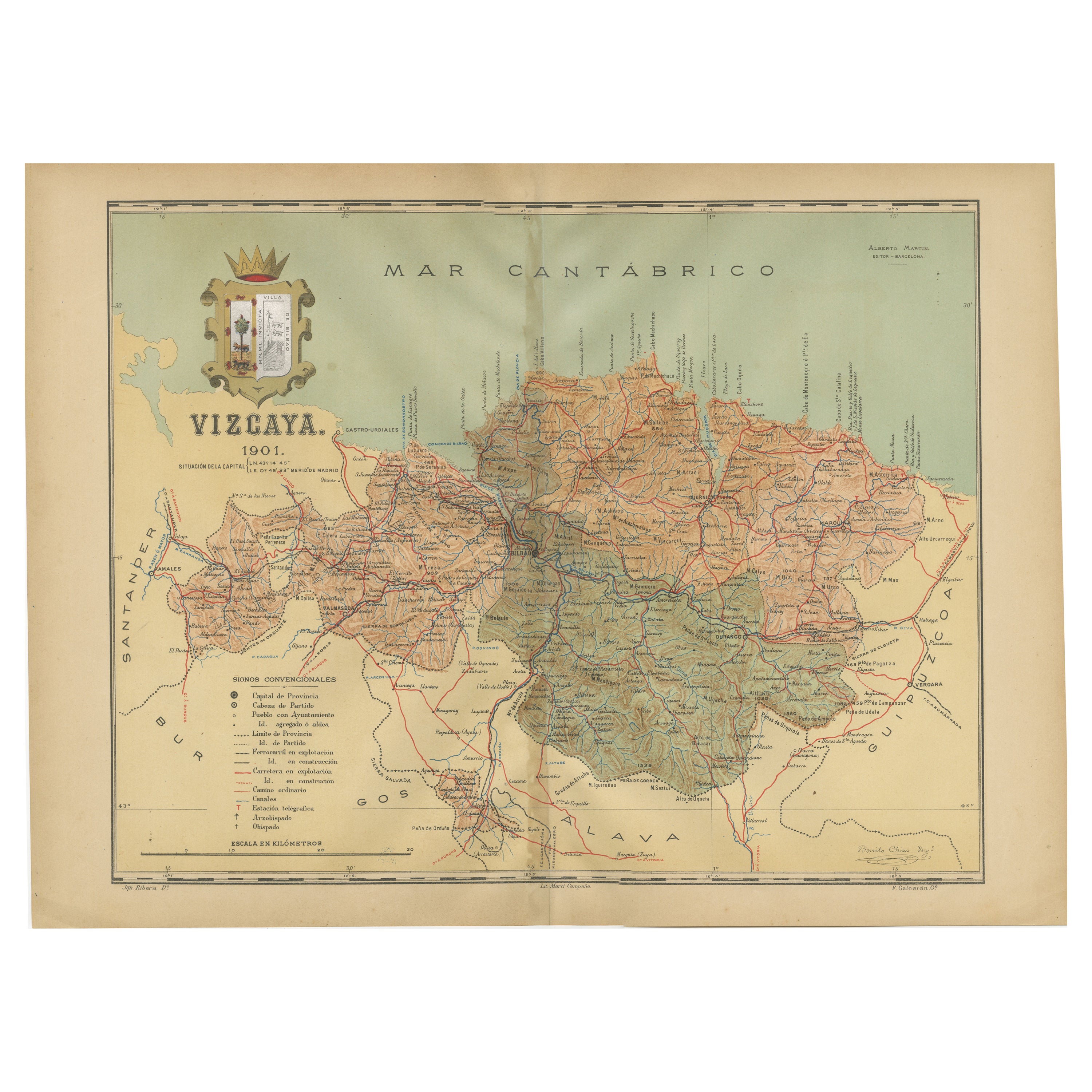
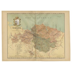
View AllCartographic Heritage: The 1901 Map of the Vizcaya Province in Spain
Located in Langweer, NL
This is a historical map of the province of Vizcaya (Biscay) in Spain, dated 1901. The title on the map is "VIZCAYA. 1901." It shows the topographical details of the region with cont...
Category
Antique Early 1900s Maps
Materials
Paper
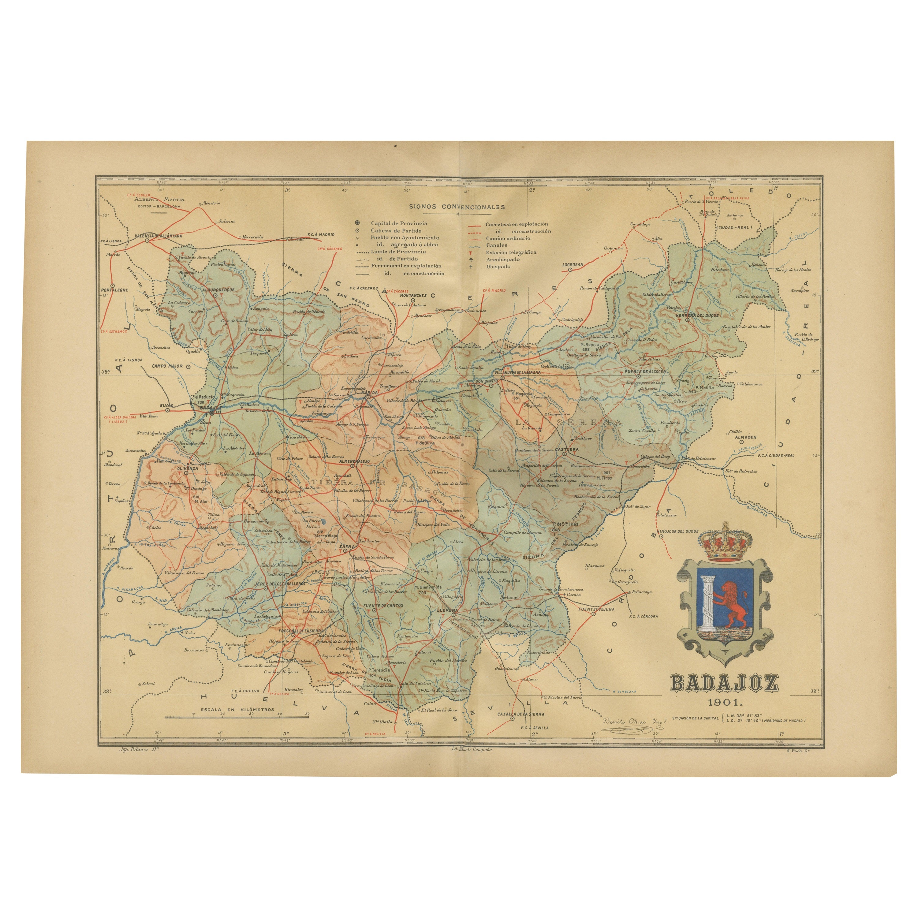
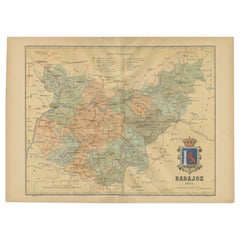
Badajoz 1901: A Cartographic Record of Extremadura's Largest Province in Spain
Located in Langweer, NL
This original antique map for sale is of the province of Badajoz, part of the autonomous community of Extremadura in Spain, dated 1901. It illustrates several important features:
Th...
Category
Antique Early 1900s Maps
Materials
Paper
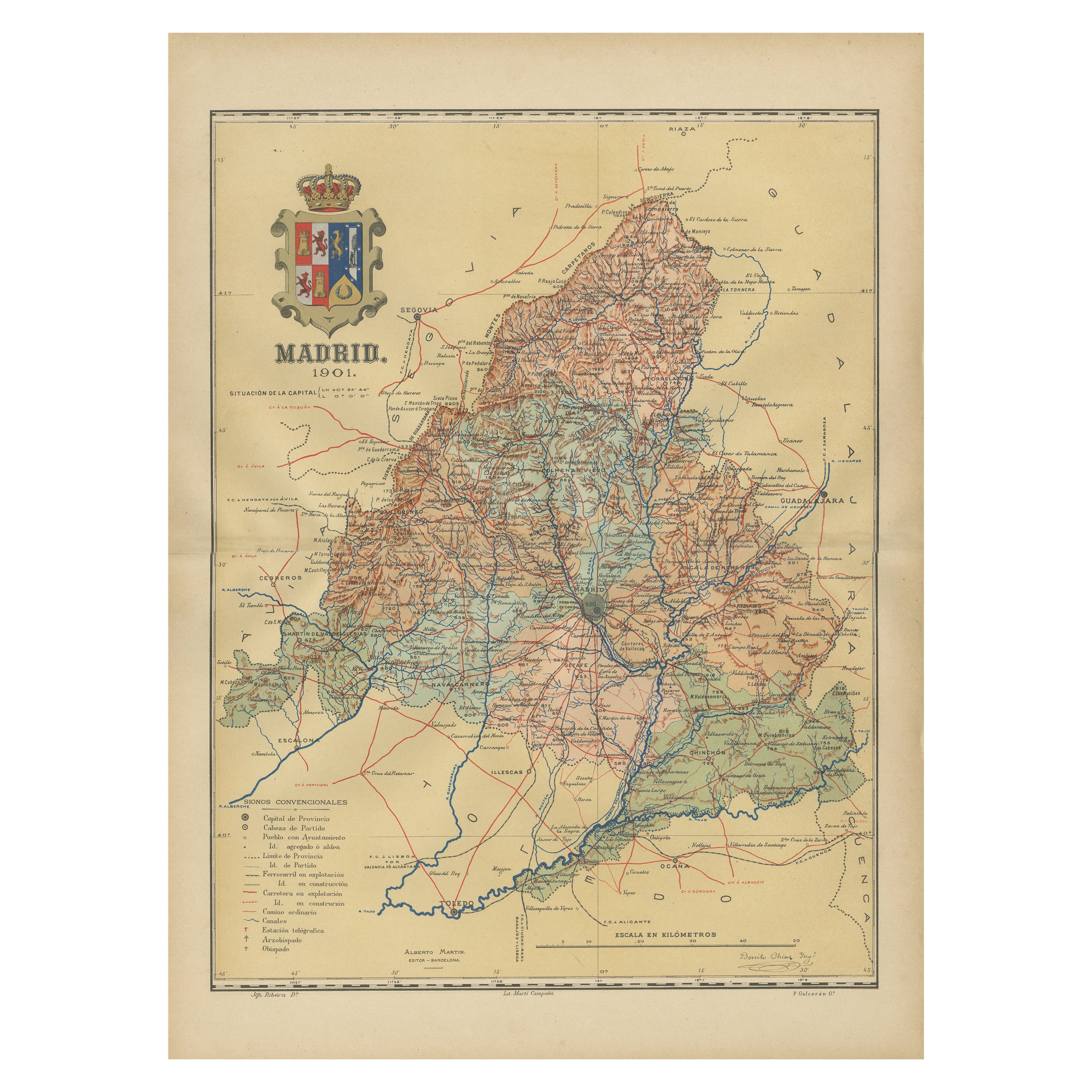
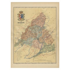
Madrid 1901: A Historical Map of Spain's Capital Province
Located in Langweer, NL
The map is of the province of Madrid, the capital region of Spain, as it appeared in 1901. Here are the key features it displays:
The map shows the central part of Spain, with the Guadarrama mountain range prominently visible, marking the natural border to the north of Madrid.
Blue lines likely indicate rivers, including the Manzanares River, which flows through Madrid, and the Jarama River, a tributary to the Tagus.
Red lines depict the roads and railways, outlining the infrastructure that connects Madrid's various towns and cities within the province and beyond.
Symbols and labels mark the locations of cities, towns, and villages, with Madrid itself likely being the focal point. Dotted lines may represent the administrative divisions within the province. The map includes a legend (Signos Convencionales) that explains the symbols used for provincial capitals, roads, railways, and other geographic features.
The coat of arms of Madrid, featuring a bear and a strawberry tree (madroño), is prominently featured, symbolizing the city's and the province's historical coat of arms.
About the province of Madrid:
Madrid is not only the capital of Spain but also the heart of the Iberian Peninsula, both geographically and politically. The city is renowned for its rich repositories of European art, including the Prado Museum's works by Goya, Velázquez, and other Spanish masters. The province of Madrid is characterized by a blend of historical and modern elements, with a rich cultural life that includes theater, opera, and flamenco, as well as gastronomy that features a mix of traditional Spanish dishes and international cuisine...
Category
Antique Early 1900s Maps
Materials
Paper
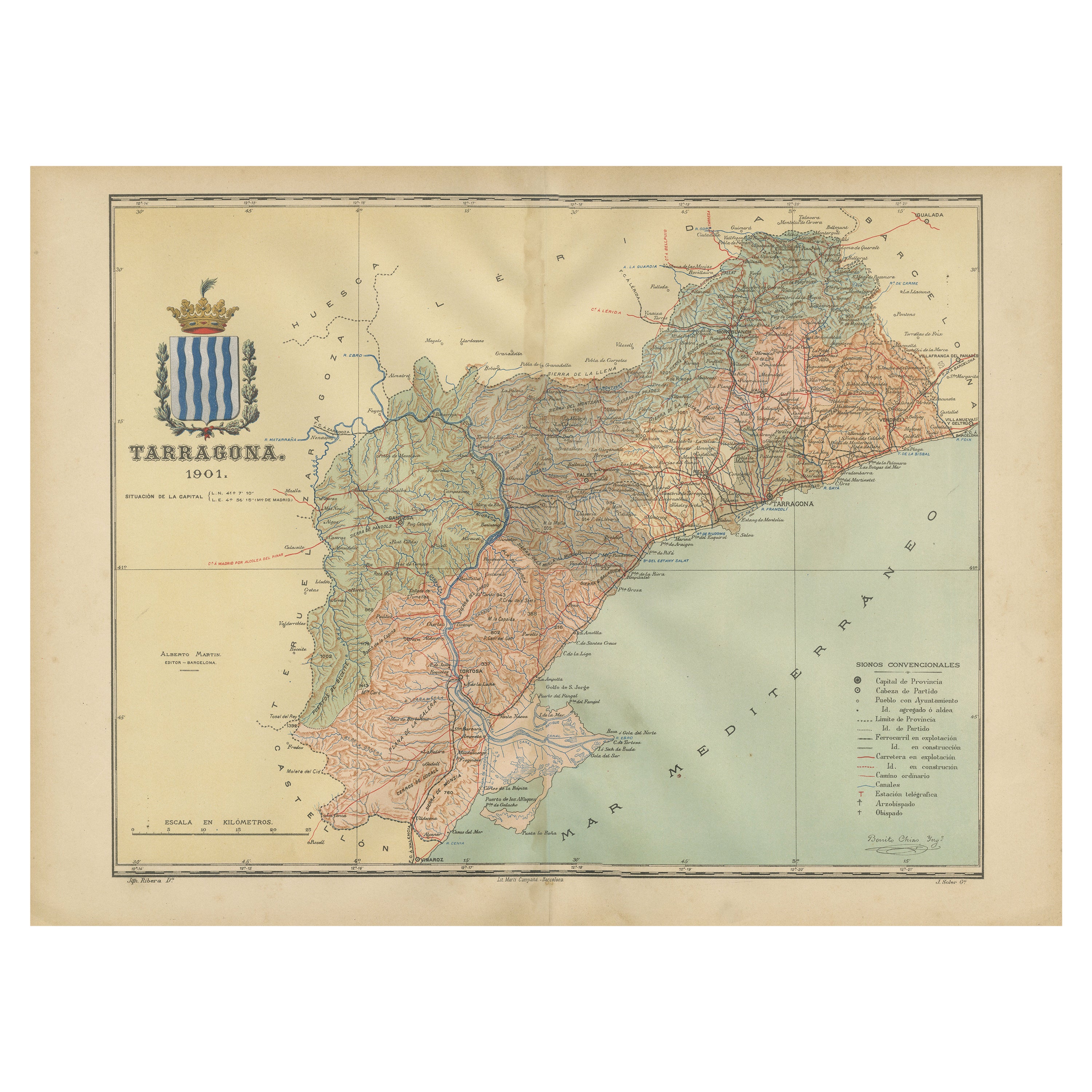
A Catalonian Cartographic Depiction of Tarragona Province, 1901
Located in Langweer, NL
This image depicts a historical map of the province of Tarragona, which is in the northeastern part of Spain, within the autonomous community of Catalonia. The map is dated 1901, sug...
Category
Antique Early 1900s Maps
Materials
Paper

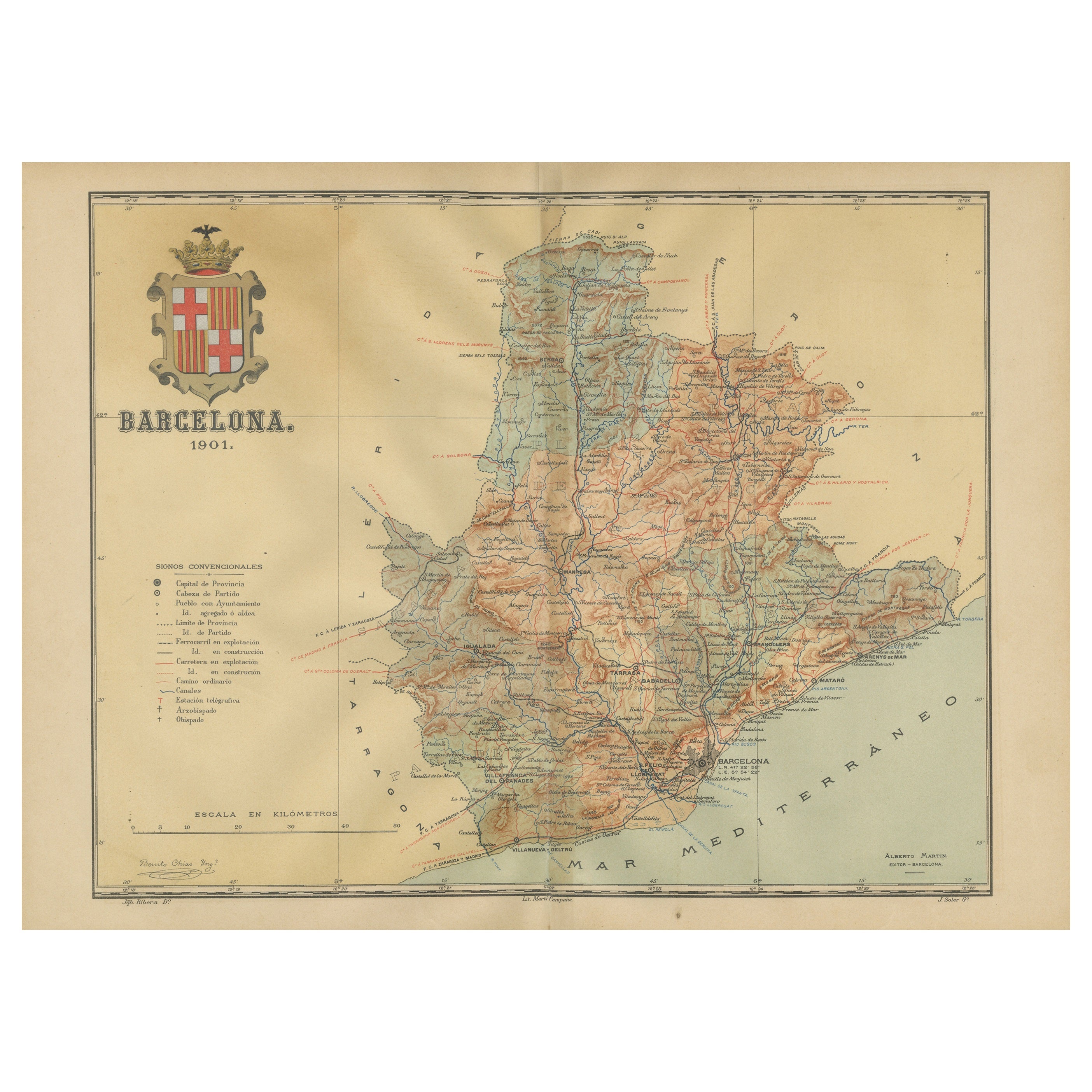
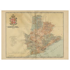
Barcelona 1901: A Cartographic Portrait of Catalonia's Capital Province
Located in Langweer, NL
This orignal antique map is a historical depiction of the province of Barcelona from 1901.
It showcases the varied terrain of the province, with the Serra de Collserola ridge near the city of Barcelona and the Pyrenees to the north. The map includes the coastline along the Mediterranean Sea, indicating Barcelona's position as a coastal province. Blue lines indicate rivers, such as the Llobregat and Besòs, which are significant features in the province's geography. Dotted lines may signify the borders of the province within Catalonia.
The coat of arms of Barcelona, highlighted with gold, is prominently displayed, featuring the Cross of Saint George (Cruz de Sant Jordi), the patron saint of Catalonia, and the red and yellow bars which are a symbol of the Aragonese and Catalan heritage.
About the province of Barcelona:
The province of Barcelona is part of the autonomous community of Catalonia in northeastern Spain. It is the most economically significant region of Catalonia, playing a crucial role in the country's economy due to its port, manufacturing, and service industries. The city of Barcelona is the capital and the second most populous city in Spain, known for its rich cultural heritage, architecture by Antoni Gaudí, such as the Sagrada Família, and its influential art scene. The province enjoys a Mediterranean climate and features diverse landscapes from the beaches along the coast to the mountains in the interior. Barcelona is also known for its vibrant festivals, cuisine, fashion, and sports, particularly football, being home to FC Barcelona...
Category
Antique Early 1900s Maps
Materials
Paper
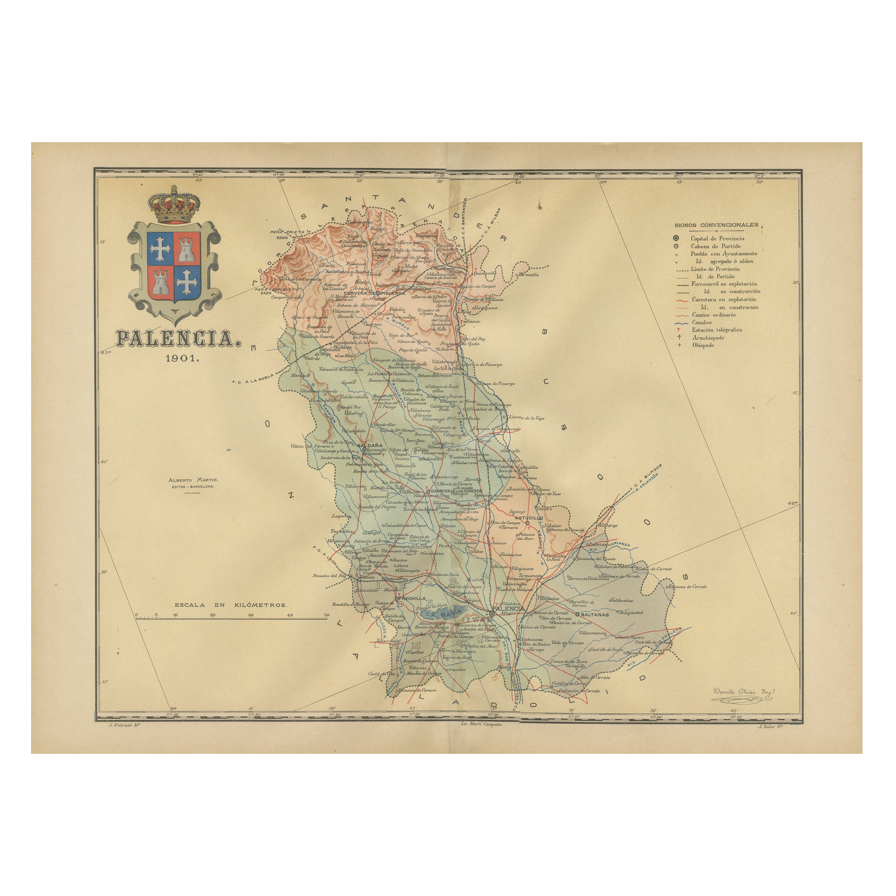
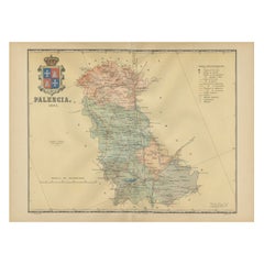
Original Antique Map of Palencia Province, in Northern Spain, 1901
Located in Langweer, NL
This historical map is of Palencia, a province in the northern part of Spain.
Palencia is situated within the autonomous community of Castilla y León. It is bordered by the provinc...
Category
Antique Early 1900s Maps
Materials
Paper
You May Also Like
Antique Lithography Map, Isle of Thanet, Kent, English, Cartography, Victorian
Located in Hele, Devon, GB
This is an antique lithography map of The Isle of Thanet in Kent. An English, framed atlas engraving of cartographic interest, dating to the mid 19th century and later.
Superb litho...
Category
Antique Mid-19th Century British Victorian Maps
Materials
Wood

Very Large Vintage Map of Canada, German, Education, Institution, Cartography
Located in Hele, Devon, GB
This is a very large vintage map of Canada. A German, quality printed educational or institution map, dating to the mid 20th century, circa 1965....
Category
Mid-20th Century German Maps
Materials
Paper

Antique County Map of Cheshire, Dutch, Framed, Cartography, Janssonius, C.1660
Located in Hele, Devon, GB
This is an antique county map of Cheshire. A Dutch, framed atlas engraving by Johannes Janssonius, dating to the 17th century and later.
A treat for the collector or county native,...
Category
Antique Mid-17th Century Dutch Charles II Maps
Materials
Glass, Wood, Paper

Antique Environs of Bath & Bristol Map, English, Framed Cartography, Victorian
Located in Hele, Devon, GB
This is an antique region map of Bath and Bristol. An English, framed atlas engraving of cartographic interest, dating to the mid 19th century and later.
Superb lithography of Bath...
Category
Antique Mid-19th Century British Victorian Maps
Materials
Glass, Wood, Paper
Antique Lithography Map, Cumberland, English, Framed, Cartography, Victorian
Located in Hele, Devon, GB
This is an antique lithography map of Cumberland. An English, framed atlas engraving of cartographic interest, dating to the mid 19th century and la...
Category
Antique Mid-19th Century British Victorian Maps
Materials
Wood

Antique Lithography Map, Westmoreland, English, Framed, Cartography, Victorian
Located in Hele, Devon, GB
This is an antique lithography map of Westmoreland. An English, framed atlas engraving of cartographic interest, dating to the mid 19th century and later.
Superb lithography of the ...
Category
Antique Mid-19th Century British Victorian Maps
Materials
Wood
Recently Viewed
View AllMore Ways To Browse
The Circo
Spanish Santos
Silver Plate Art Deco Cocktail Shaker
Small Dining Table With Extension
Square Club Chair
Sterling Condiment
Sugar Creamer Tray
Swivel Ottomans
Tavolino Coffee Table
Three Seat Leather Danish Sofa
Tooled Leather Chairs
Trestle Chair
Trophy Silver Cup
Turkish Textile Framed
Tweed Upholstery
Twist Pedestal Table
Vintage 1950s Hat
Vintage Limestone Table