Items Similar to Map of the Region of Basel and Northern Switzerland by Ortelius, circa 1603


Want more images or videos?
Request additional images or videos from the seller
1 of 5
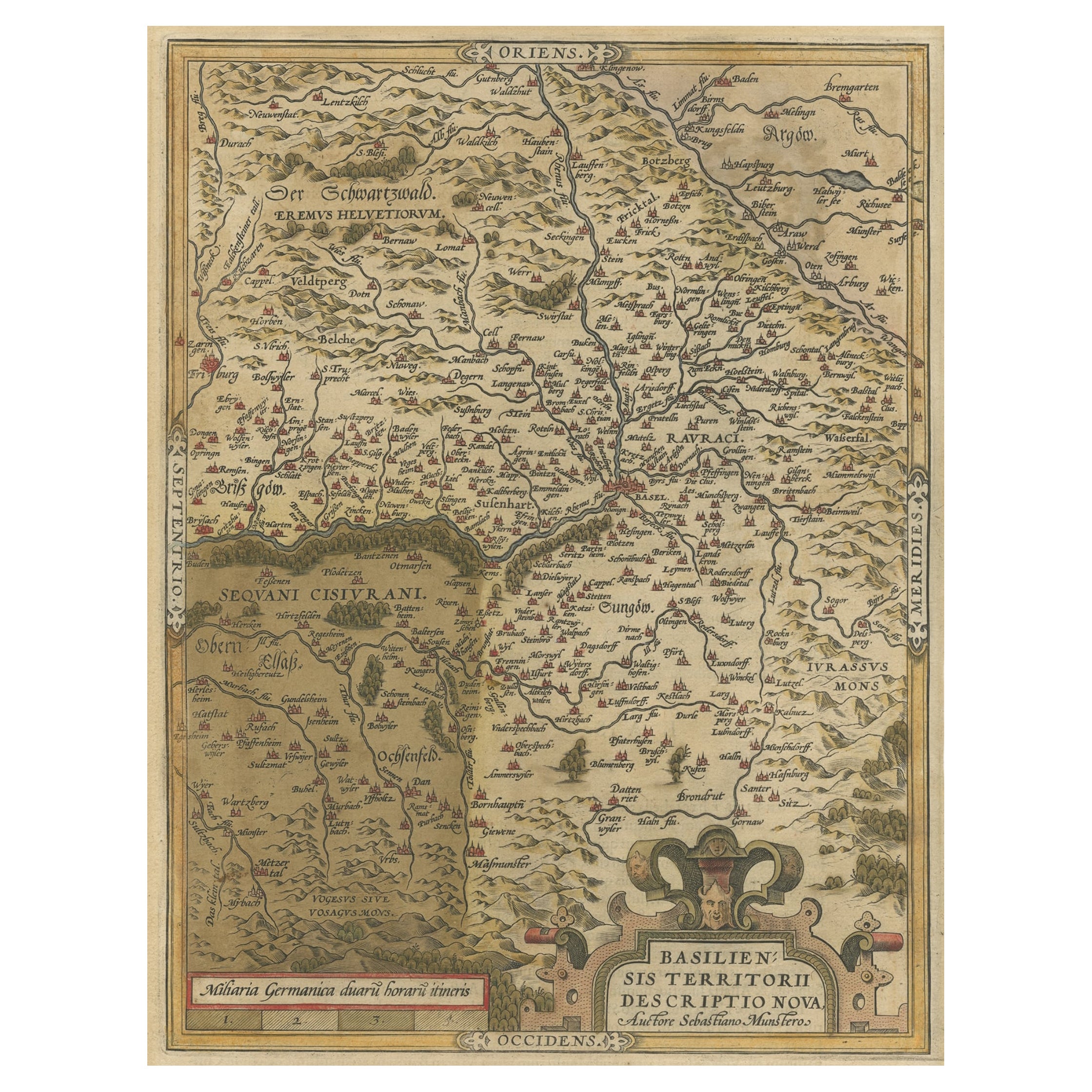
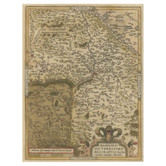
Map of the Region of Basel and Northern Switzerland by Ortelius, circa 1603
About the Item
Two original antique maps on one sheet titled 'Basiliensis Territorii Descriptio Nova [with] Circulus sive Liga Sueviae'. The first centers on Basel, Switzerland, located on the Rhine River, and is based on Munster's map of 1538. The second map is based on Seltzin's map of 1572 and shows the region of northern Switzerland and southern Germany along the Rhine River and west to the Black Forest. Both are decorated with elaborate cartouches. Published by A. Ortelius, circa 1603.
- Dimensions:Height: 17.72 in (45 cm)Width: 22.05 in (56 cm)Depth: 0.02 in (0.5 mm)
- Materials and Techniques:
- Period:Early 17th Century
- Date of Manufacture:circa 1603
- Condition:Original/contemporary hand coloring. Latin text on verso. Shows some wear and small tears (mainly in margins. General age-related toning. Please study images carefully.
- Seller Location:Langweer, NL
- Reference Number:Seller: BG-128871stDibs: LU3054322271522
About the Seller
5.0
Recognized Seller
These prestigious sellers are industry leaders and represent the highest echelon for item quality and design.
Platinum Seller
Premium sellers with a 4.7+ rating and 24-hour response times
Established in 2009
1stDibs seller since 2017
2,417 sales on 1stDibs
Typical response time: <1 hour
- ShippingRetrieving quote...Shipping from: Langweer, Netherlands
- Return Policy
Authenticity Guarantee
In the unlikely event there’s an issue with an item’s authenticity, contact us within 1 year for a full refund. DetailsMoney-Back Guarantee
If your item is not as described, is damaged in transit, or does not arrive, contact us within 7 days for a full refund. Details24-Hour Cancellation
You have a 24-hour grace period in which to reconsider your purchase, with no questions asked.Vetted Professional Sellers
Our world-class sellers must adhere to strict standards for service and quality, maintaining the integrity of our listings.Price-Match Guarantee
If you find that a seller listed the same item for a lower price elsewhere, we’ll match it.Trusted Global Delivery
Our best-in-class carrier network provides specialized shipping options worldwide, including custom delivery.More From This Seller
View AllAntique Map of the Region of Salzburg by Ortelius 'circa 1606'
Located in Langweer, NL
Antique map titled 'Salisburgensis Iurisdictionis'. Original antique map of the region of Salzburg, Austria. Published by A. Ortelius, circa 1606.
Category
Antique Early 17th Century Maps
Materials
Paper

Antique Map of the Region of Poitou by Ortelius, circa 1600
Located in Langweer, NL
Antique map titled 'Poictou'. Original antique map of the region of Poitou, a former province of west-central France whose capital city was Poitiers. Published by A. Ortelius, circa ...
Category
Antique Early 17th Century Maps
Materials
Paper

Antique Map of the Picardy Region of France by Ortelius, 'circa 1590'
Located in Langweer, NL
Antique map titled 'Picardiae Belgicae regionis descriptio'. Original antique map of the Picardy region, France. Published by A. Ortelius, circa 1590.
Category
Antique 16th Century Maps
Materials
Paper

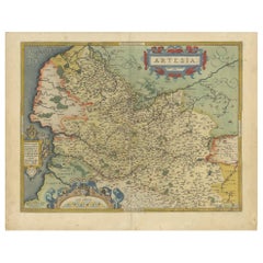
Antique Map of the Artois Region of France by Ortelius, 'circa 1590'
Located in Langweer, NL
Antique map titled 'Artesia'. Original antique map of the Artois region, France. Published by A. Ortelius, circa 1590.
Category
Antique 16th Century Maps
Materials
Paper
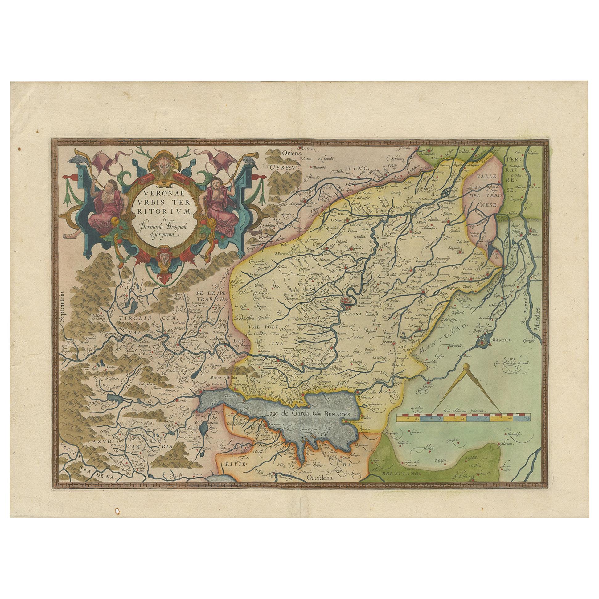
Antique Map of the Region of Verona 'Italy' by Ortelius, circa 1584
Located in Langweer, NL
Antique map titled 'Veronae Urbis Terratorium'. Original antique map of the Verona region, Italy. Centered on Verona, and including Mantua, and Lago de Garda. Published by A. Orteliu...
Category
Antique Late 19th Century Maps
Materials
Paper
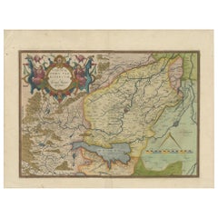
Very Old Original Hand-Colored Map of the Basel Region, Switzerland, Ca.1578
Located in Langweer, NL
Antique print titled 'Basiliensis territorii descriptio nova'.
Old map of the Basel region, Switzerland. Originates from 'Theatrum Orbis Terrarum' by A. Ortelius.
Artists and...
Category
Antique 16th Century Maps
Materials
Paper
You May Also Like
The Normandy Region of France: A 17th C. Hand-colored Map by Sanson and Jaillot
By Nicolas Sanson
Located in Alamo, CA
This large hand-colored map entitled "Le Duché et Gouvernement de Normandie divisée en Haute et Basse Normandie en divers Pays; et par evêchez, avec le Gouvernement General du Havre ...
Category
Antique 1690s French Maps
Materials
Paper

17th Century Hand Colored Map of the Liege Region in Belgium by Visscher
By Nicolaes Visscher II
Located in Alamo, CA
An original 17th century map entitled "Leodiensis Episcopatus in omnes Subjacentes Provincias distincté divisusVisscher, Leodiensis Episcopatus" by Nicolaes Visscher II, published in Amsterdam in 1688. The map is centered on Liege, Belgium, includes the area between Antwerp, Turnhout, Roermond, Cologne, Trier and Dinant.
This attractive map is presented in a cream-colored mat measuring 30" wide x 27.5" high. There is a central fold, as issued. There is minimal spotting in the upper margin and a tiny spot in the right lower margin, which are under the mat. The map is otherwise in excellent condition.
The Visscher family were one of the great cartographic families of the 17th century. Begun by Claes Jansz Visscher...
Category
Antique Late 17th Century Dutch Maps
Materials
Paper

Original Antique Map of Switzerland, Engraved By Barlow, Dated 1807
Located in St Annes, Lancashire
Great map of Switzerland
Copper-plate engraving by Barlow
Published by Brightly & Kinnersly, Bungay, Suffolk.
Dated 1807
Unframed.
Category
Antique Early 1800s English Maps
Materials
Paper

17th Century Hand-Colored Map of a Region in West Germany by Janssonius
By Johannes Janssonius
Located in Alamo, CA
This attractive highly detailed 17th century original hand-colored map is entitled "Archiepiscopatus Maghdeburgensis et Anhaltinus Ducatus cum terris adjacentibus". It was published ...
Category
Antique Mid-17th Century Dutch Maps
Materials
Paper

Northern Scotland: A 16th Century Hand-colored Map by Mercator
By Gerard Mercator
Located in Alamo, CA
A framed hand-colored 16th century map of Northern Scotland by Gerard Mercator entitled "Scotiae pars Septentrionalis", published in Amsterdam in 1636. It is a highly detailed map of the northern part of Scotland, with the northwest Highlands and the cities Inverness and Aberdeen, as well as the Orkney Islands and the Hebrides. There is a decorative title cartouche in the upper left corner.
The map is presented in an antiqued brown wood...
Category
Antique 16th Century Dutch Maps
Materials
Paper

Northern Scotland: A 17th Century Hand-colored Map by Mercator
By Gerard Mercator
Located in Alamo, CA
This is a framed hand-colored 17th century map of Northern Scotland by Gerard Mercator entitled "Scotiae pars Septentrionalis", published in Amsterdam in 1636. It is a highly detailed map of the northern part of Scotland, with the northwest Highlands and the cities Inverness and Aberdeen, as well as the Orkney Islands and the Hebrides. There is a decorative title cartouche in the upper left corner.
The map is presented in an antiqued brown wood...
Category
Antique 1630s Dutch Maps
Materials
Paper

Recently Viewed
View AllMore Ways To Browse
Antique Map Iceland
Antique Maps Of Malta
Map Holder
Mitchell Antique Maps
Antique Geological Maps
Antique Map Of Kent
Antique Map Of Maine
Victorian Portico
Vintage Wooden Roller
Von Gotha
Antique Chart Table
Antique Map Palestine
Antique Maps Hampshire
Antique Powder Tins
Brooklyn Map
Map Of Colorado
Antique Bermuda Furniture
Antique Life Buoy