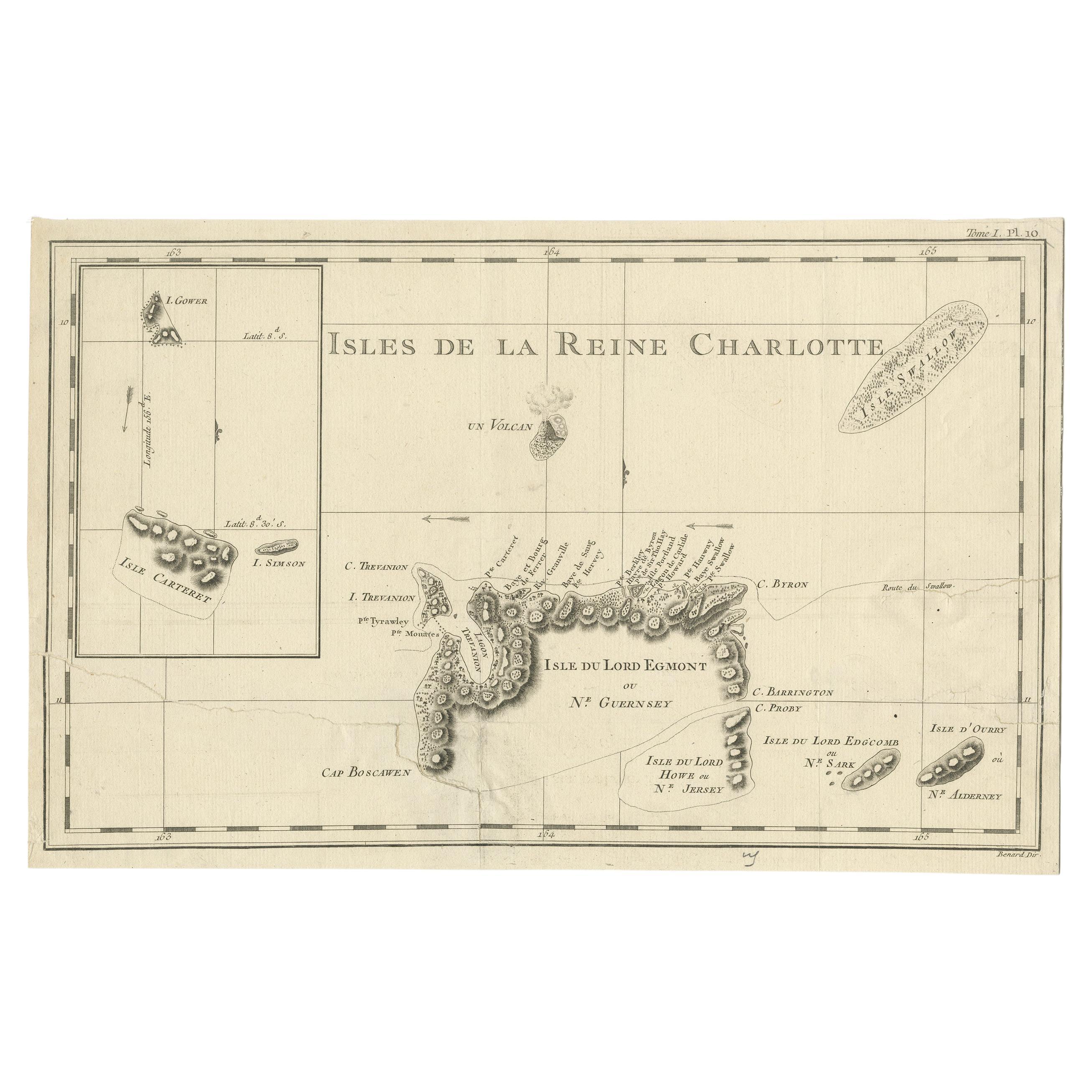
Items Similar to Map of Queen Charlotte's, Carteret's, Simson's and Gower's Islands, Canada, 1773


Want more images or videos?
Request additional images or videos from the seller
1 of 5
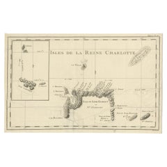
Map of Queen Charlotte's, Carteret's, Simson's and Gower's Islands, Canada, 1773
About the Item
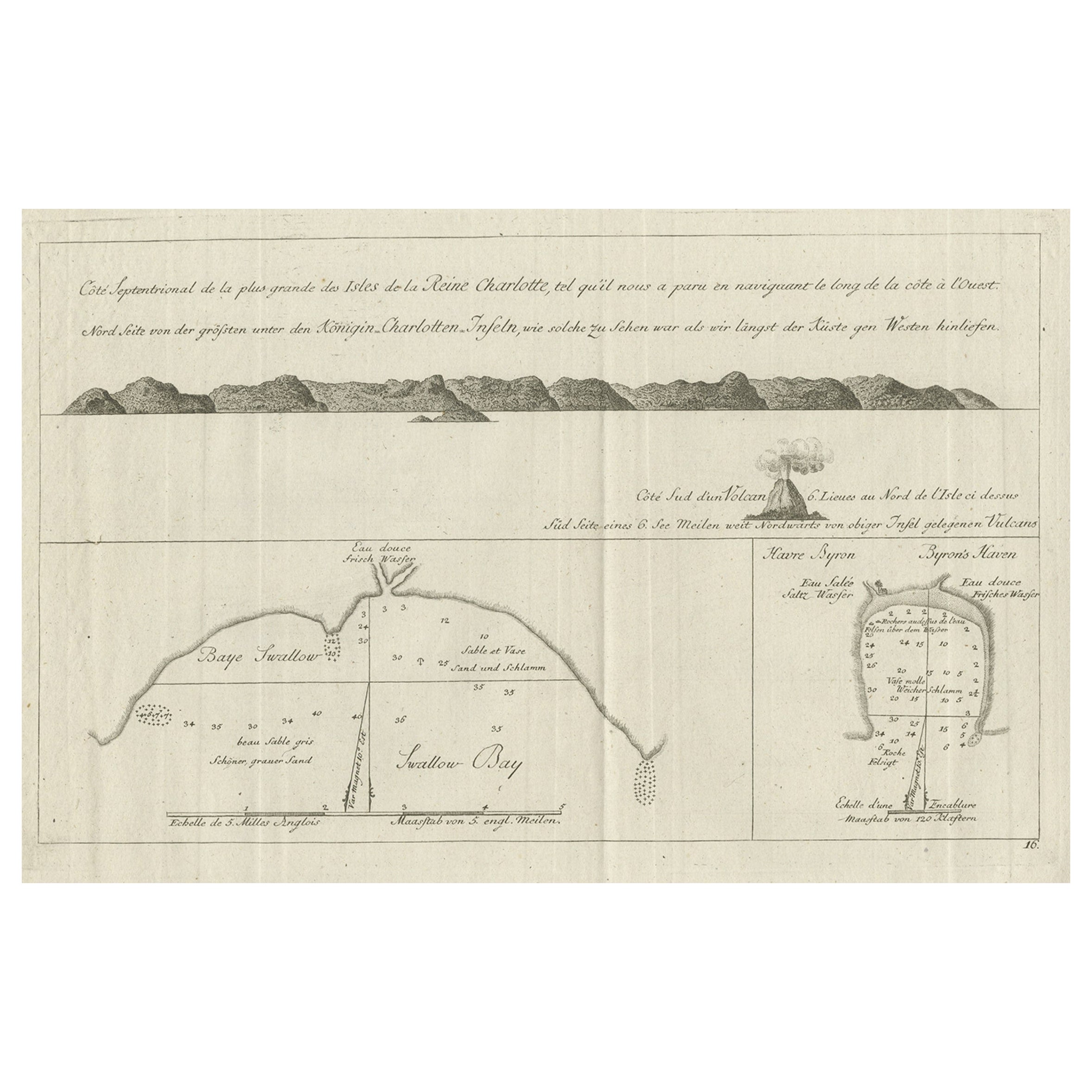
Antique map Canada titled 'Queen Charlotte's Islands'.
Old map of Queen Charlotte's Islands, Canada. With an inset map of Carteret's, Simson's and Gower's islands. Shows the Swallow's track. Originates from 'A New, Authentic and Complete Collection of Voyages Around the World after measurements from Voyages by James Cook 1728-79'.
Artists and Engravers: Author: George William Anderson.
Condition: Fair, age-related toning and some staining. Few pieces of tape, please study image carefully.
- Dimensions:Height: 10.63 in (27 cm)Width: 16.54 in (42 cm)Depth: 0 in (0.02 mm)
- Materials and Techniques:
- Period:1770-1779
- Date of Manufacture:1773
- Condition:
- Seller Location:Langweer, NL
- Reference Number:Seller: BGJC-2131stDibs: LU3054326710782
About the Seller
5.0
Recognized Seller
These prestigious sellers are industry leaders and represent the highest echelon for item quality and design.
Platinum Seller
Premium sellers with a 4.7+ rating and 24-hour response times
Established in 2009
1stDibs seller since 2017
2,415 sales on 1stDibs
Typical response time: 1 hour
- ShippingRetrieving quote...Shipping from: Langweer, Netherlands
- Return Policy
Authenticity Guarantee
In the unlikely event there’s an issue with an item’s authenticity, contact us within 1 year for a full refund. DetailsMoney-Back Guarantee
If your item is not as described, is damaged in transit, or does not arrive, contact us within 7 days for a full refund. Details24-Hour Cancellation
You have a 24-hour grace period in which to reconsider your purchase, with no questions asked.Vetted Professional Sellers
Our world-class sellers must adhere to strict standards for service and quality, maintaining the integrity of our listings.Price-Match Guarantee
If you find that a seller listed the same item for a lower price elsewhere, we’ll match it.Trusted Global Delivery
Our best-in-class carrier network provides specialized shipping options worldwide, including custom delivery.More From This Seller
View AllOld View of the Queen Charlotte's Islands 'Santa Cruz Islands, Solomon', 1774
Located in Langweer, NL
Antique map titled 'Cote Septentrional de la plus grande des Isles de la Reine Charlotte (..)'.
Map and coastal view of the islands within the Queen Charlotte's Islands (Santa Cruz Islands...
Category
Antique 1770s Maps
Materials
Paper
$332 Sale Price
20% Off
Antique Map of the Islands Within the Queen Charlotte's Islands
Located in Langweer, NL
Antique map titled 'Cote Septentrional de la plus grande des Isles de la Reine Charlotte (..)'. Map and coastal view of the islands within the Queen Charlotte's Islands (Santa Cruz I...
Category
Antique Late 18th Century Maps
Materials
Paper

Antique Map of New Guinea and New Britain by P. Carteret, circa 1773
Located in Langweer, NL
Antique Map: A Chart of Captain Carteret's Discoveries at New Britain (1769)
This rare and historically significant 18th-century map, titled *A Chart of Captn Carteret's Discoveries at New Britain,* offers a fascinating glimpse into early European explorations of the Pacific. Published in 1769, the map meticulously charts Captain Philip Carteret's 1767 voyage through New Guinea and the islands of New Britain and New Ireland, showcasing his contributions to the understanding of the Bismarck Archipelago. Adding to its significance, the map traces the paths of earlier explorer William Dampier...
Category
Antique Late 18th Century Maps
Materials
Paper

Antique Map of the Santa Cruz Islands with Inset of Carteret and Gower Islands
Located in Langweer, NL
Antique map titled 'Isles de la Reine Charlotte (..)'. A detailed chart of the Santa Cruz islands, to the north of the New Hebrides, with Carteret's track in "Swallow"; including an ...
Category
Antique Late 18th Century Maps
Materials
Paper
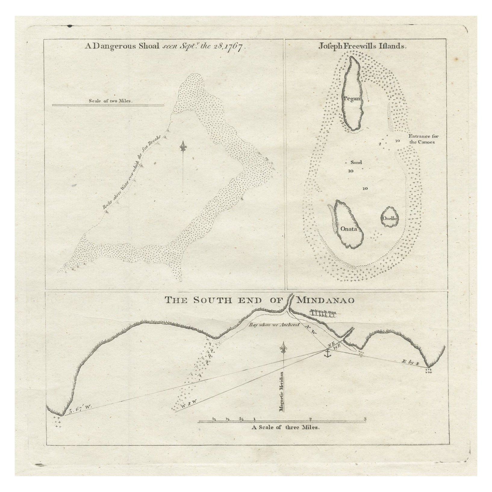
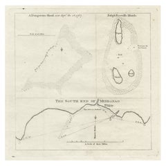
Rare Map of the Philippines; Joseph Freewills Island & Mindanao South End, 1773
Located in Langweer, NL
Three charts on one sheet titled '1) A Dangerous Shoal 2) Joseph Freewills Island 3) The South End of Mindanao'.
It shows Captain Carteret's voyage: Saint George's Channel to Min...
Category
Antique 1770s Maps
Materials
Paper
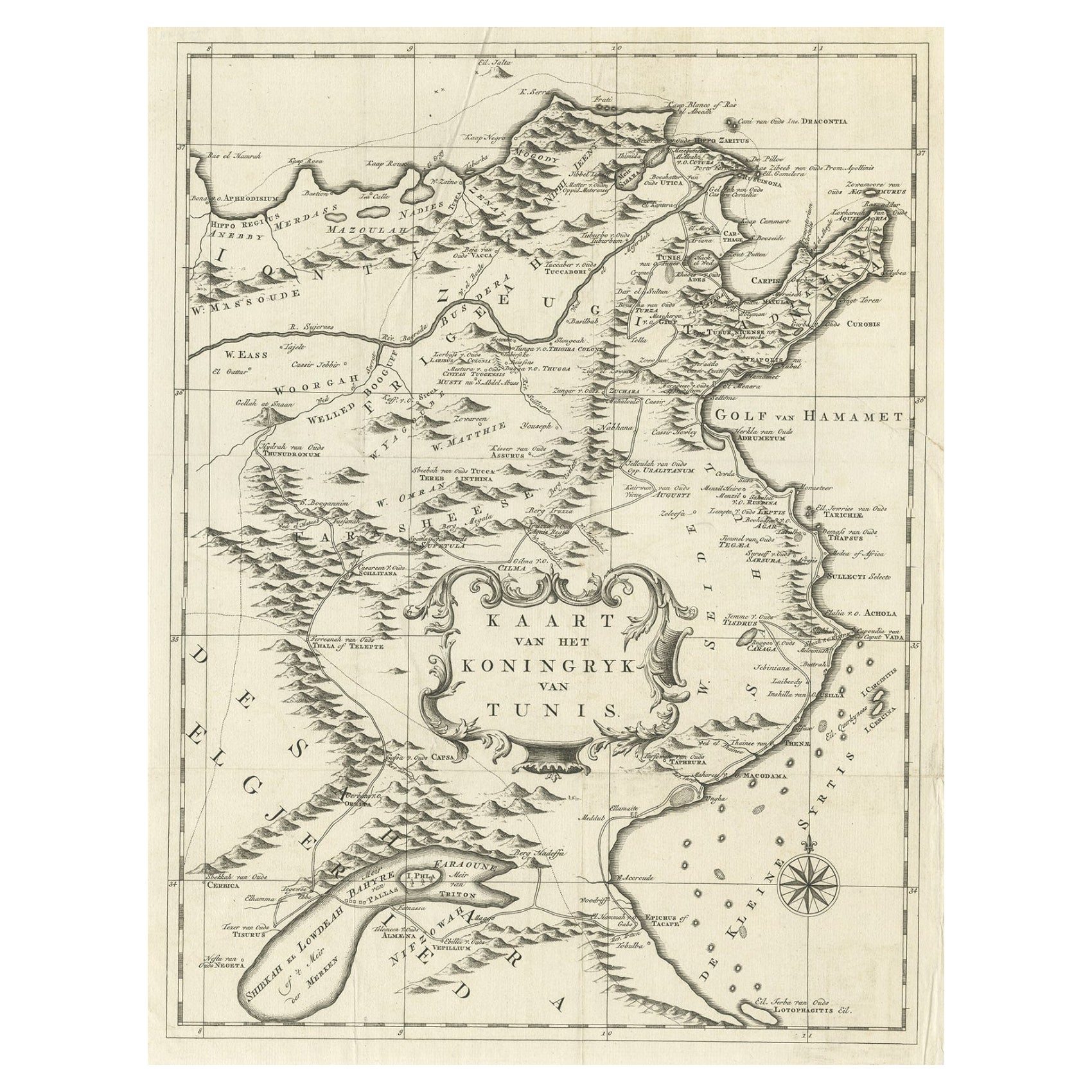
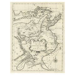
Antique Map of the Kingdom of Tunisia, Africa, 1773
Located in Langweer, NL
Antique map titled 'Kaart van het Koningryk van Tunis'. Old map of the Kingdom of Tunisia. Originates from the first Dutch editon of an interesting travel account of Northern Africa ...
Category
Antique 18th Century Maps
Materials
Paper
You May Also Like
Hand-Colored 18th Century Homann Map of Denmark and Islands in the Baltic Sea
By Johann Baptist Homann
Located in Alamo, CA
An 18th century copper plate hand-colored map entitled "Insulae Danicae in Mari Balthico Sitae utpote Zeelandia, Fionia, Langelandia, Lalandia, Falstria, Fembria Mona" created by Joh...
Category
Antique Early 18th Century German Maps
Materials
Paper

St. Christophe 'St. Kitts' Island: An 18th Century Hand-colored Map by Bellin
By Jacques-Nicolas Bellin
Located in Alamo, CA
Jacques Bellin's copper-plate map of the Caribbean island of Saint Kitts entitled "Carte De De l'Isle St. Christophe Pour servir á l'Histoire Genle. des V...
Category
Antique Mid-18th Century French Maps
Materials
Paper

Antique Map of Principality of Monaco
By Antonio Vallardi Editore
Located in Alessandria, Piemonte
ST/619 - "Old Geographical Atlas of Italy - Topographic map of ex-Principality of Monaco" -
ediz Vallardi - Milano -
A somewhat special edition ---
Category
Antique Late 19th Century Italian Other Prints
Materials
Paper

Map of the Republic of Genoa
Located in New York, NY
Framed antique hand-coloured map of the Republic of Genoa including the duchies of Mantua, Modena, and Parma.
Europe, late 18th century.
Dimension: 25...
Category
Antique Late 18th Century European Maps

Old Horizontal Map of England
By Tasso
Located in Alessandria, Piemonte
ST/520 - Old rare Italian map of England, dated 1826-1827 - by Girolamo Tasso, editor in Venise, for the atlas of M.r Le-Sage.
Category
Antique Early 19th Century Italian Other Prints
Materials
Paper

Original Antique Map of Spain and Portugal, circa 1790
Located in St Annes, Lancashire
Super map of Spain and Portugal
Copper plate engraving by A. Bell
Published, circa 1790.
Unframed.
Category
Antique 1790s English Other Maps
Materials
Paper

Recently Viewed
View AllMore Ways To Browse
Queen Charlotte
George Cook
Chippendale Tea Table
Danish Design Serving Tray
Danish Modern Side Table Glass
Delft Polychrome
Eames Aluminum Group Chairs Leather
Engraved Glass Bell
Factory Stools Vintage
Floor Pouf
Folding Stool Seat
French 18th Century Bureaus
French Divider Screen
French Tripod Stool
Heriz 1880
Herman Miller Eames Aluminum Group Desk Chair
Hollywood Regency Gilt Cocktail Table
India Rosewood