Items Similar to Map of Kingdoms of Castile, León, Galicia, Asturias, Biscay and Navarre in Spain

Want more images or videos?
Request additional images or videos from the seller
1 of 10
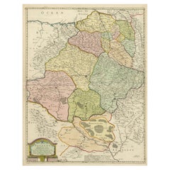
Map of Kingdoms of Castile, León, Galicia, Asturias, Biscay and Navarre in Spain
About the Item
Antique map titled 'Partie Septentrionale de la Couronne de Castille (..)'. Decorative and highly detailed map of Northwestern Spain, including Gallicia, Leon, Asturias, Old Castille, New Castille and Biscaya. Extends to Madrid and Toledo. Published by Vaugondy, circa 1752.
Description:
This historical map, titled "Partie Septentrionale de la Couronne de Castille*, was created in 1752 by the renowned French cartographer Robert de Vaugondy. The map illustrates the northern part of Spain, encompassing the regions known historically as the Kingdoms of Old Castile, León, Galicia, Asturias, Biscay, and Navarre. These areas were significant during the time as they formed the northern territories of the Spanish Crown, known as the "Crown of Castile."
Notable Features:
- Cartographer: Robert de Vaugondy, a distinguished French geographer, known for his detailed and accurate maps, was the official cartographer to the King of France. His works are highly regarded for their precision and artistry.
- Important Places:
- Madrid (shown towards the southern part of the map, emphasizing its importance as the capital of Spain).
- Santiago de Compostela (a historic city in Galicia, famous for the cathedral that is the destination of the Camino de Santiago pilgrimage).
- Burgos and Valladolid (key cities in Old Castile, important for their historical and cultural significance).
- Oviedo (the capital of Asturias, known for its medieval old town).
- Pamplona (capital of Navarre, famous for the Running of the Bulls).
- Santander (an important port city in the region of Cantabria).
- Bilbao and San Sebastián (significant cities in Biscay, known for their economic and cultural importance).
Map Details:
- Scale: The map includes a scale bar, which allows the user to measure distances accurately.
- Borders: The map outlines the borders of each kingdom with different colors, helping to distinguish between the various regions.
- Geographical Features: Detailed depiction of the mountainous terrain, rivers, and coastal lines along the Bay of Biscay.
This map is not only a valuable resource for historical study but also a beautiful piece of cartographic art, reflecting the geographical knowledge and political boundaries of mid-18th century Spain.
Gilles Robert de Vaugondy (1688-1766) and Didier Robert de Vaugondy (1723-1786) were influential figures in the realm of 18th-century French cartography. Originating from Paris, their contributions to mapmaking were significant during an era of expansive geographical exploration.
- Dimensions:Height: 20.48 in (52 cm)Width: 27.88 in (70.8 cm)Depth: 0.02 in (0.5 mm)
- Materials and Techniques:
- Period:
- Date of Manufacture:c.1752
- Condition:General age-related toning. Original folding line. Shows some wear, blank verso. Please study image carefully.
- Seller Location:Langweer, NL
- Reference Number:Seller: BG-13430-11stDibs: LU3054339031912
About the Seller
5.0
Recognized Seller
These prestigious sellers are industry leaders and represent the highest echelon for item quality and design.
Platinum Seller
Premium sellers with a 4.7+ rating and 24-hour response times
Established in 2009
1stDibs seller since 2017
2,412 sales on 1stDibs
Typical response time: 1 hour
- ShippingRetrieving quote...Shipping from: Langweer, Netherlands
- Return Policy
Authenticity Guarantee
In the unlikely event there’s an issue with an item’s authenticity, contact us within 1 year for a full refund. DetailsMoney-Back Guarantee
If your item is not as described, is damaged in transit, or does not arrive, contact us within 7 days for a full refund. Details24-Hour Cancellation
You have a 24-hour grace period in which to reconsider your purchase, with no questions asked.Vetted Professional Sellers
Our world-class sellers must adhere to strict standards for service and quality, maintaining the integrity of our listings.Price-Match Guarantee
If you find that a seller listed the same item for a lower price elsewhere, we’ll match it.Trusted Global Delivery
Our best-in-class carrier network provides specialized shipping options worldwide, including custom delivery.More From This Seller
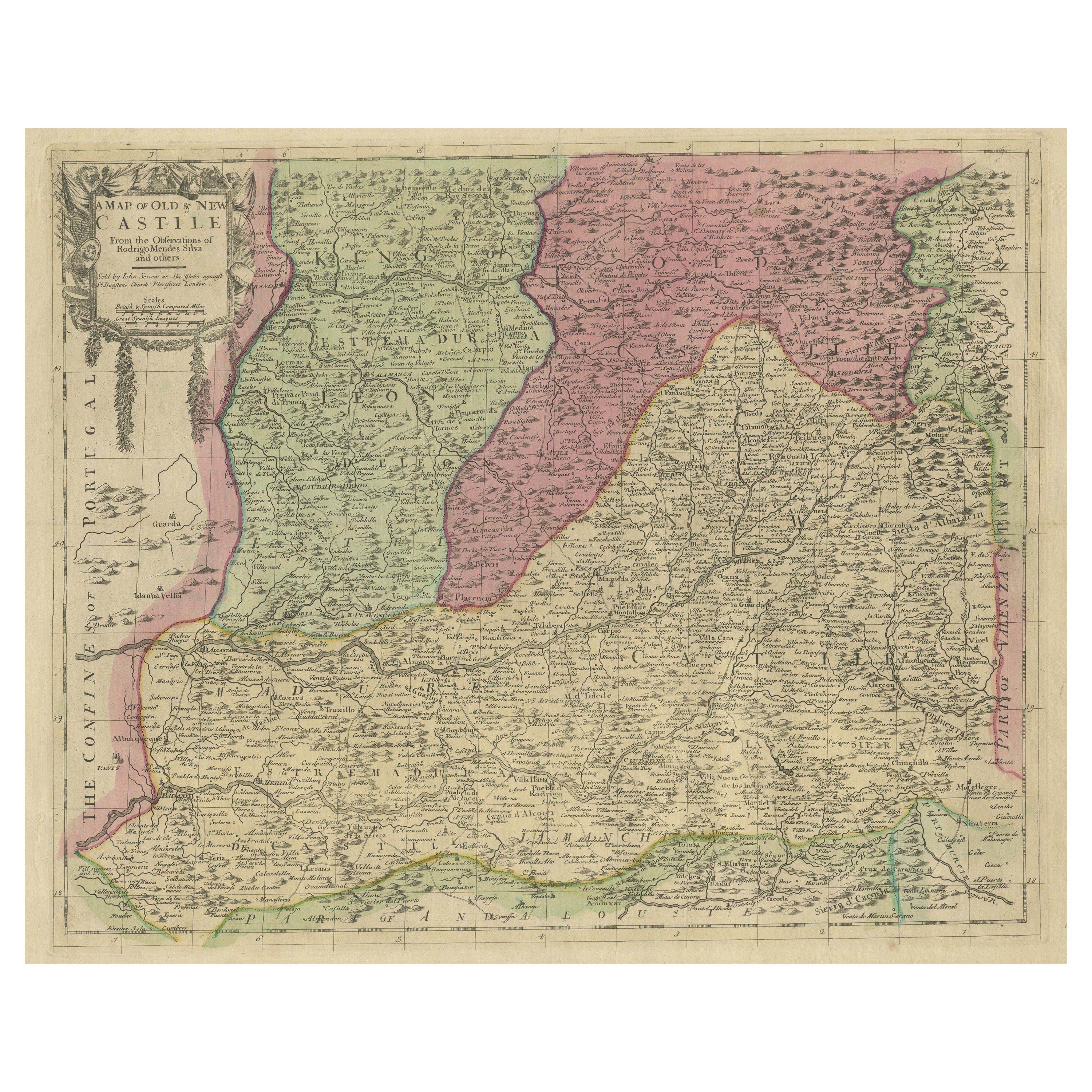
View AllSenex Map of Castile, Leon & La Mancha in The Spanish Heartland, 1714
Located in Langweer, NL
This antique map, titled "A Map of Old & New Castile from the Observations of Rodrigo Mendes Silva and others," depicts the regions of Old Castile and New Castile in Spain, along with the Kingdom of Leon, Estremadura, La Mancha, among others. The map dates back to the early 18th century, a period marked by significant political shifts and territorial changes in Europe, particularly illustrated by the War of the Spanish Succession (1701–1714) that reshaped Spain’s governance and regional boundaries.
The map itself was published in 1714 by John Senex, a prominent English mapmaker, surveyor, globemaker, and geographer of the early eighteenth century. He was apprenticed as a young man to bookseller Robert Clavell and collaborated with notable mapmakers such as Jeremiah Seller and Charles Price. In 1728, Senex's contributions to geography and mapping were recognized when he was elected a Fellow of the Royal Society, an exceptional honor for a mapmaker, underlining his significant role as the Society's engraver and a publisher of maps by Edmund Halley and other notable figures.
John Senex is renowned for his English Atlas, first published in the same year as this map, 1714, and continued to be printed until the 1760s. Following his death in 1740, his widow Mary Senex managed the business until 1755. Afterward, the stock passed to William Herbert and Robert Sayer for maps, and to James Ferguson for globes.
The map serves not just as a geographical record but also as a historical document, reflecting the territorial divisions significant to Spain's political and economic structure at the time. The focus on Old and New Castile underscores their importance during a transformative era in Spanish history.
Here are some potentially significant places and features of this map:
1. **Old Castile (Castilla la Vieja)**: Historically significant as part of the former Kingdom of Castile, this region includes major cities such as Burgos and Valladolid. These cities could be popular search...
Category
Antique Early 18th Century Maps
Materials
Paper
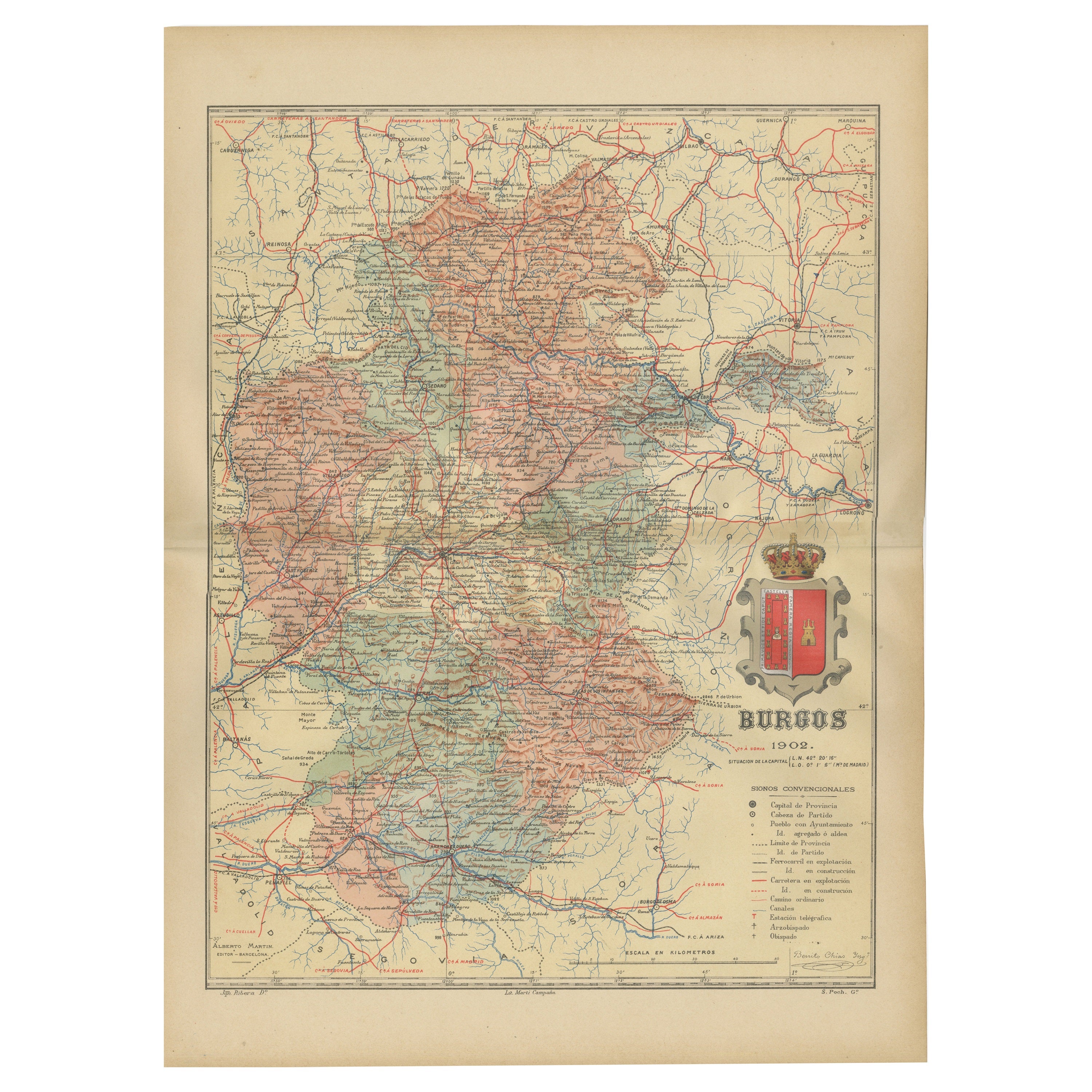
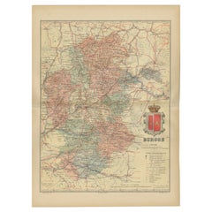
Burgos 1902: Geographic Map of Castile's Historic Heartland in Spain
Located in Langweer, NL
The map of the province of Burgos in the autonomous community of Castile and León in Spain, dated 1902. It includes the following features:
The map highlights the varied terrain wit...
Category
Antique Early 1900s Maps
Materials
Paper
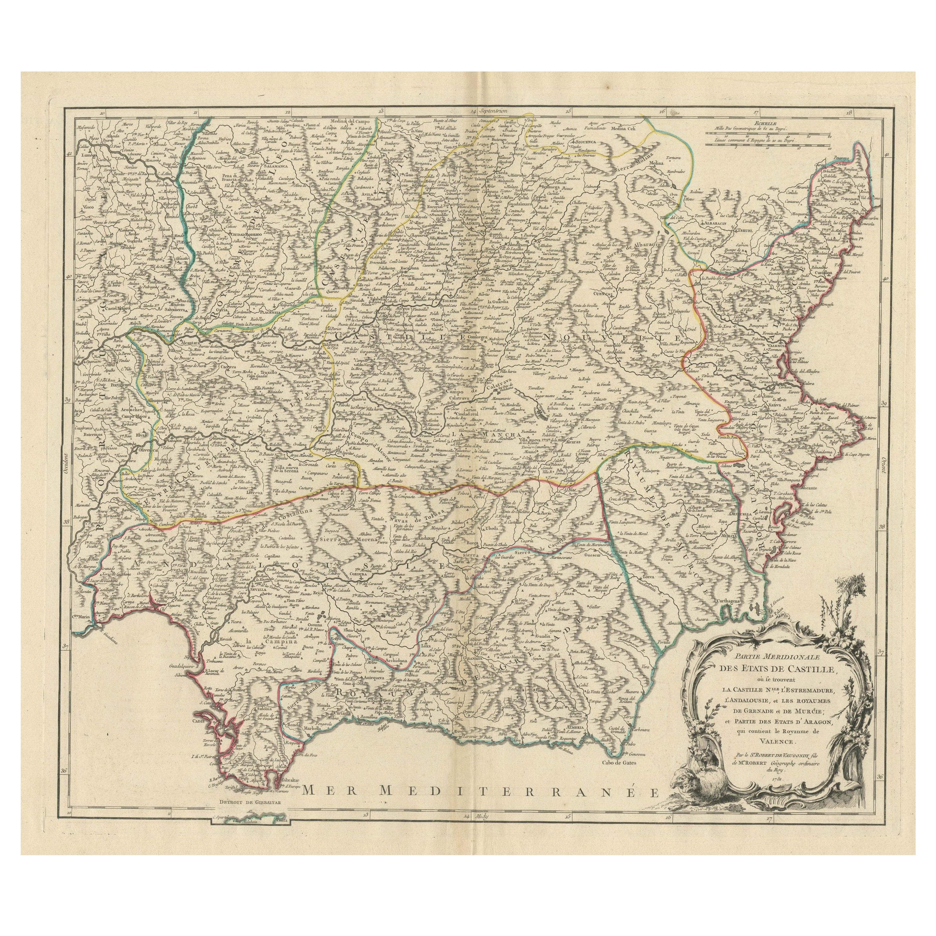
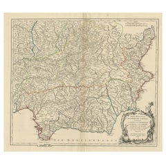
Map of Southern Spain Depicting Castile, Andalusia, Granada, Murcia and Valencia
Located in Langweer, NL
Antique map titled 'Partie Meridionale Des Etats de Castille (..)'. Decorative and highly detailed map of the southern part of Castile, Spain, including a decorative cartouche. Publi...
Category
Antique Mid-18th Century Maps
Materials
Paper
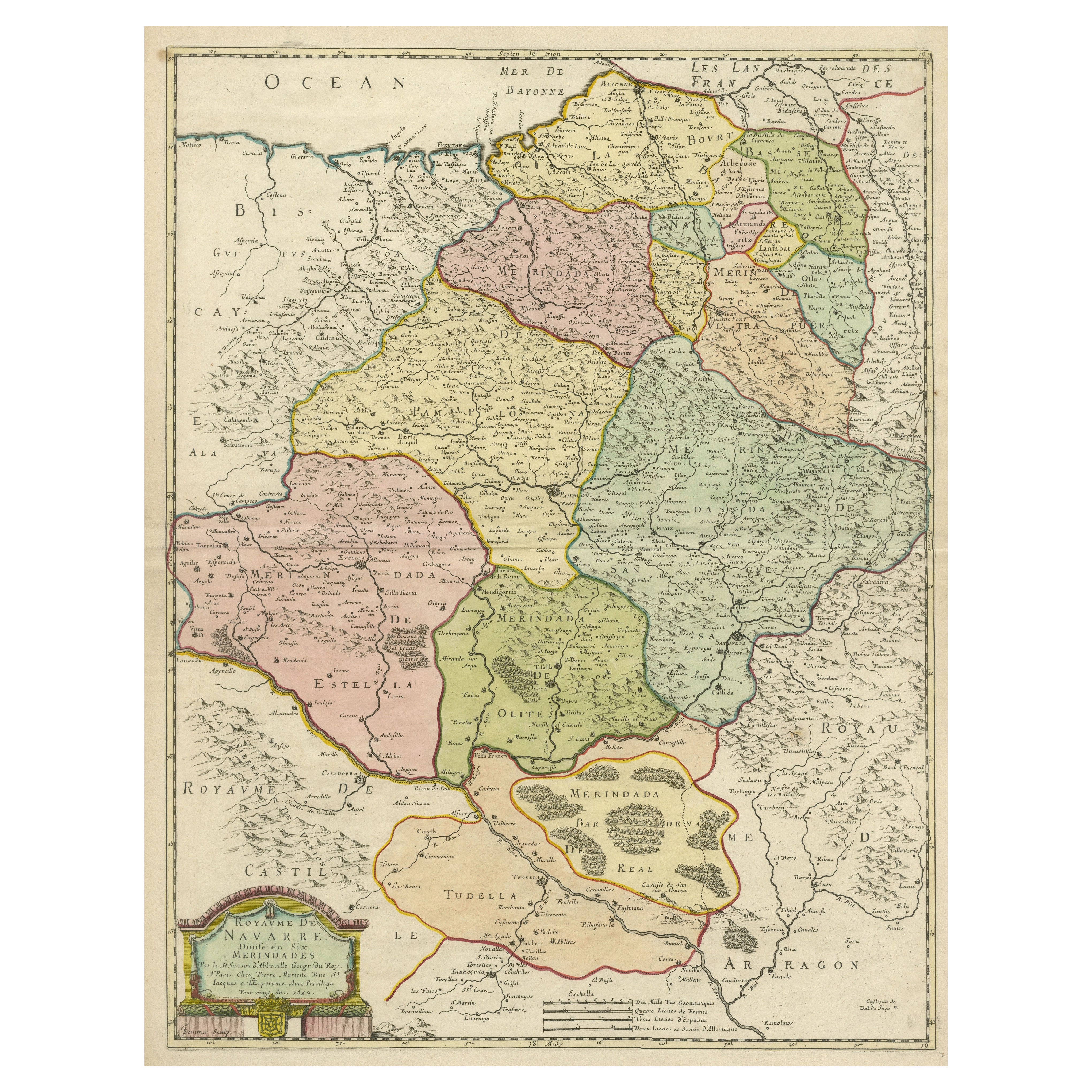
Antique Map of the Province of Navarre with the City of Pamplona, Spain
Located in Langweer, NL
Antique map titled 'Royaume de Navarre (..)'. Decorative map of the province Navarre (Spanish: Navarra) in Northern Spain centered on the city of Pamplona. Published by N. Sanson, 16...
Category
Antique Mid-17th Century Maps
Materials
Paper
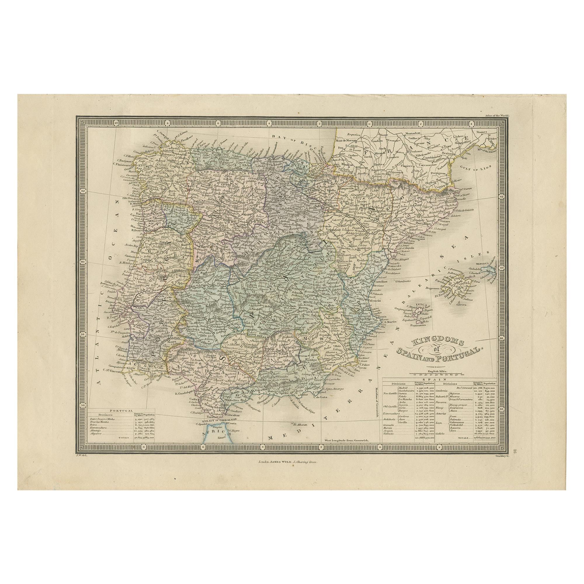
Antique Map of the Kingdoms of Spain and Portugal by Wyld '1845'
Located in Langweer, NL
Antique map titled 'Kingdoms of Spain and Portugal'. Original antique map of the Kingdoms of Spain and Portugal. This map originates from 'An Atlas of the World, Comprehending Separa...
Category
Antique Mid-19th Century Maps
Materials
Paper

Orense in Depth: A 1902 Topographical Map of Galicia's Mountainous Province
Located in Langweer, NL
The map is a detailed cartographic representation of the province of Orense (Ourense in Galician), located in the northwest of Spain, as it was in 1902. Here's a brief description an...
Category
Antique Early 1900s Maps
Materials
Paper

You May Also Like
Map of the Kingdom of Sardinia and Part of the Kingdom of Genoa, Rome
By Giovanni Maria Cassini
Located in Hamilton, Ontario
18th century map by Italian engraver Giovanni Maria Cassini (Italy 1745-1824). Map of Part of the Kingdom of Sardinia and Part of the Kingdom of Genoa: Rome. This is a hand colored a...
Category
Antique 18th Century Italian Maps
Materials
Paper

$795 Sale Price
36% Off
Large Original Vintage Map of the United Kingdom, circa 1920
Located in St Annes, Lancashire
Great map of The United Kingdom
Unframed
Original color
By John Bartholomew and Co. Edinburgh Geographical Institute
Published, circa 1920
Free shipping.
Category
Vintage 1920s British Maps
Materials
Paper

Original Antique Map of Spain and Portugal, circa 1790
Located in St Annes, Lancashire
Super map of Spain and Portugal
Copper plate engraving by A. Bell
Published, circa 1790.
Unframed.
Category
Antique 1790s English Other Maps
Materials
Paper

The Kingdom of Naples and Southern Italy: A Hand-Colored 18th Century Homann Map
By Johann Baptist Homann
Located in Alamo, CA
"Novissima & exactissimus Totius Regni Neapolis Tabula Presentis Belli Satui Accommo Data" is a hand colored map of southern Italy and the ancient Kingdom of Naples created by Johann...
Category
Antique Early 18th Century German Maps
Materials
Paper

Large Original Vintage Map of Spain, circa 1920
Located in St Annes, Lancashire
Great map of Spain
Original color.
Good condition
Published by Alexander Gross
Unframed.
Category
Vintage 1920s English Maps
Materials
Paper
18th Century Hand Colored Map of Spain and Portugal by Visscher
By Nicolaes Visscher II
Located in Alamo, CA
This is an early 18th century map of Spain and Portugal, with attractive original hand-coloring, entitled "Hispaniae et Portugalliae Regna per Nicolaum Visscher cum Privilegio Ordinu...
Category
Antique Early 18th Century Dutch Maps
Materials
Paper

Recently Viewed
View AllMore Ways To Browse
Cathedral Crown
Used Furniture Oviedo
Antique Toledo Scale Scales
Antique Toledo Scale
Curule Seats
Czech Oak Table
Daniel And Arter Ceramics
Danish Folding Chairs
Drexel Chairs Vintage
Eames Hand Chairs
Ebonized And Cane
Egg Bowl
English Country Armchairs
Entrance Hooks
Entryway Console Marble
Expanding Dining Tables Antique
Fabric Folding Screen
Fabric Patterned Bench