Items Similar to Large Folding Map of Paris, France, on Linen, 36 Segments, Published in 1836

Want more images or videos?
Request additional images or videos from the seller
1 of 6
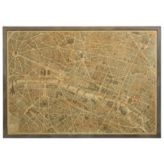
Large Folding Map of Paris, France, on Linen, 36 Segments, Published in 1836
About the Item
Antique map Paris titled 'Carte Topographique des Environs de Paris Nouvelle edition rectifié d'apres les travaux de la Nouvelle Carte De France'.
Folding map of Paris on linen, 36 segments.
Artists and Engravers: Published by J. Andriveau-Goujon, Paris, 1836.
- Dimensions:Height: 27.96 in (71 cm)Width: 39.77 in (101 cm)Depth: 0 in (0.02 mm)
- Materials and Techniques:
- Period:
- Date of Manufacture:1836
- Condition:Condition: Good, general age-related toning. Some segments a bit loose, please study image carefully.
- Seller Location:Langweer, NL
- Reference Number:Seller: BG-11542 1stDibs: LU3054327344082
About the Seller
5.0
Recognized Seller
These prestigious sellers are industry leaders and represent the highest echelon for item quality and design.
Platinum Seller
Premium sellers with a 4.7+ rating and 24-hour response times
Established in 2009
1stDibs seller since 2017
2,412 sales on 1stDibs
Typical response time: 1 hour
- ShippingRetrieving quote...Shipping from: Langweer, Netherlands
- Return Policy
Authenticity Guarantee
In the unlikely event there’s an issue with an item’s authenticity, contact us within 1 year for a full refund. DetailsMoney-Back Guarantee
If your item is not as described, is damaged in transit, or does not arrive, contact us within 7 days for a full refund. Details24-Hour Cancellation
You have a 24-hour grace period in which to reconsider your purchase, with no questions asked.Vetted Professional Sellers
Our world-class sellers must adhere to strict standards for service and quality, maintaining the integrity of our listings.Price-Match Guarantee
If you find that a seller listed the same item for a lower price elsewhere, we’ll match it.Trusted Global Delivery
Our best-in-class carrier network provides specialized shipping options worldwide, including custom delivery.More From This Seller
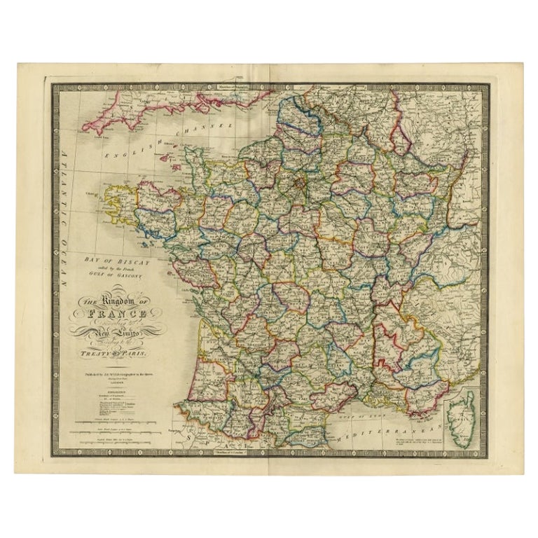
View AllAntique Map of France according to the Treaty of Paris '1815', Published in 1854
Located in Langweer, NL
Antique map titled 'The Kingdom of France, describing the new limits according to the treaty of Paris. (1815)'. Large map of France. From James Wyld's 'A New General Atlas of Modern ...
Category
Antique 19th Century Maps
Materials
Paper
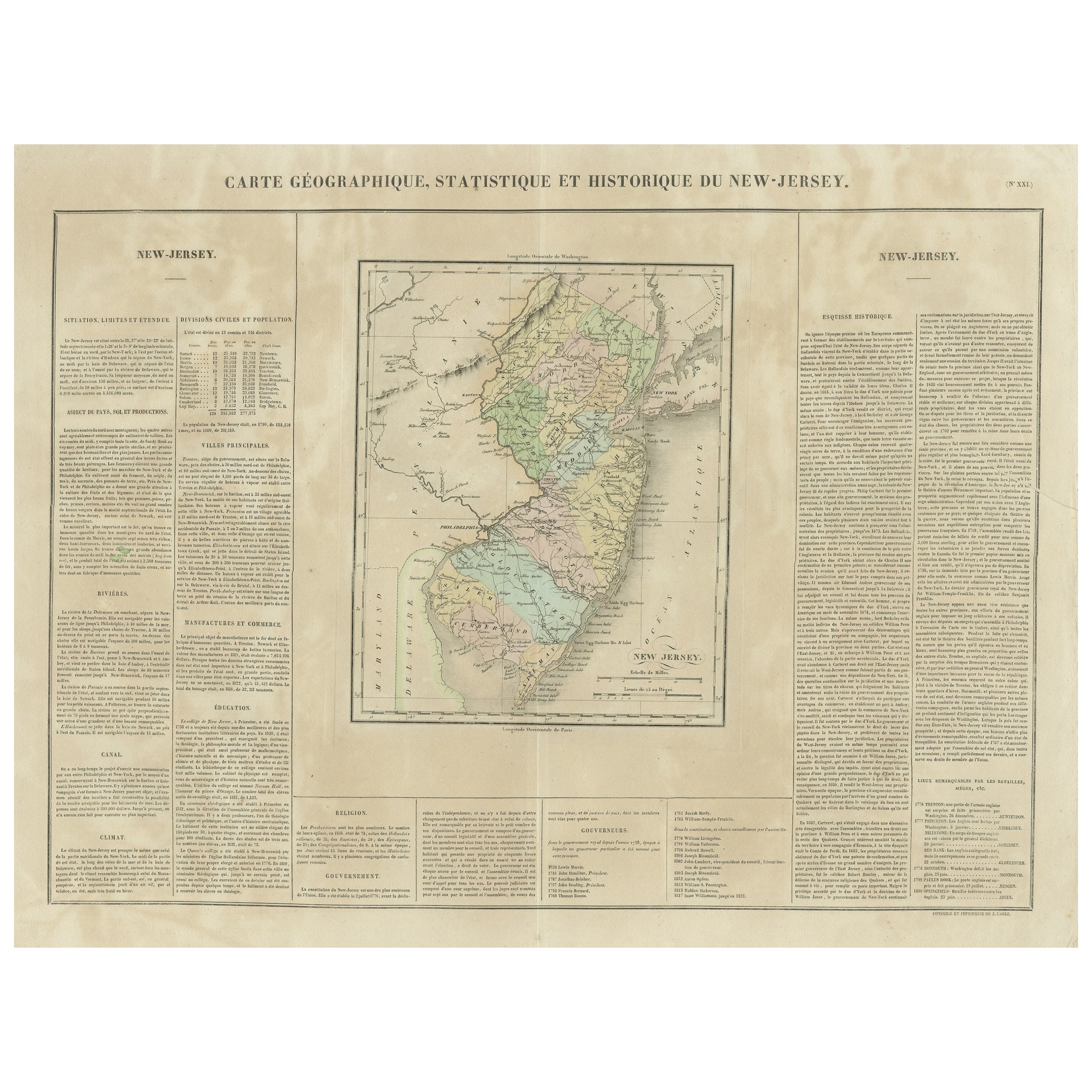
Original Antique Map of the State of New Jersey Published in France
Located in Langweer, NL
Original antique map titled 'Carte Géographique Statistique et Historique du New-Jersey'. One of the earliest obtainable maps of the State of New Jersey published outside of the Unit...
Category
Antique Early 19th Century Maps
Materials
Paper
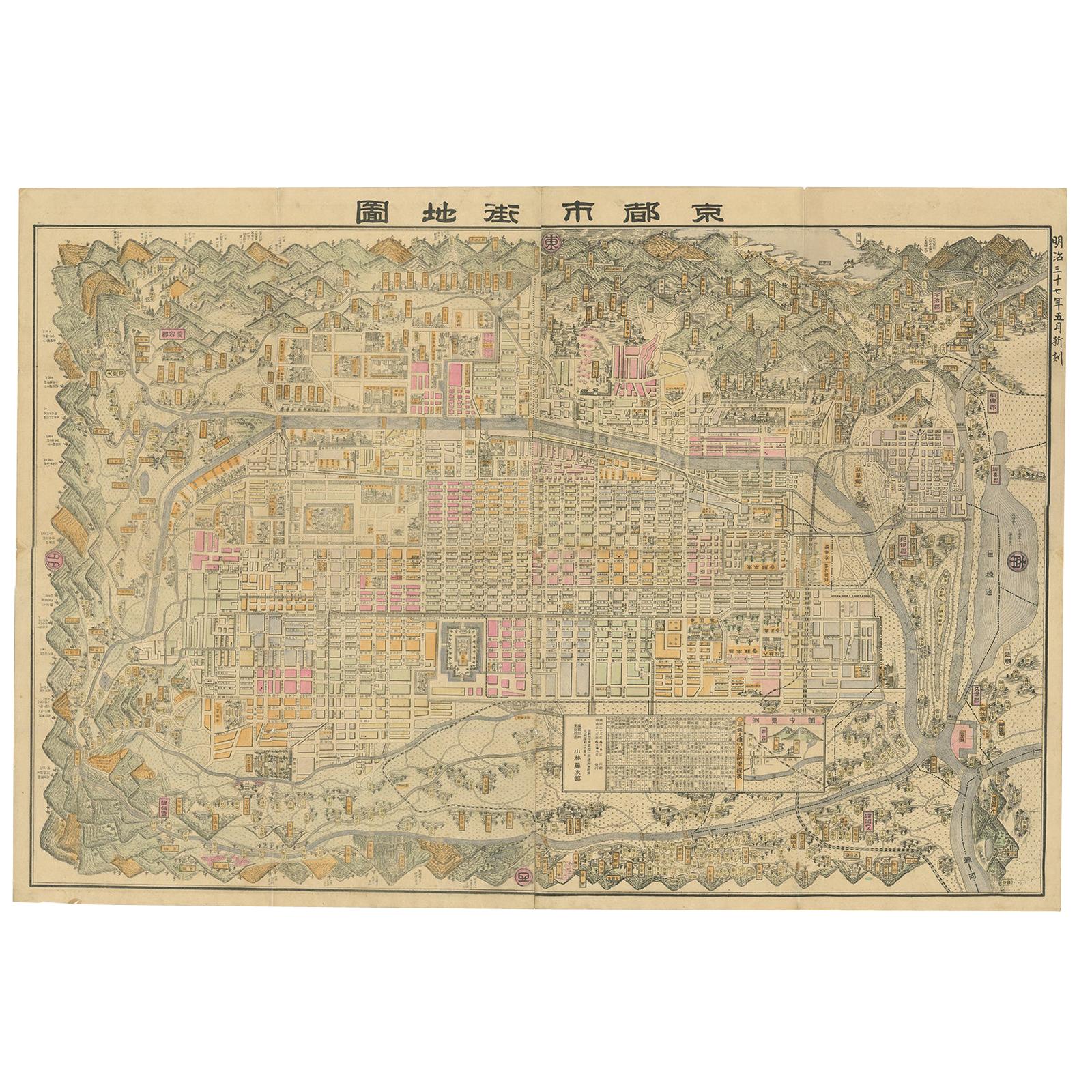
Historical Large Map of Kyoto, Japan (1905) - Published by Kobayashi
Located in Langweer, NL
Old map of Kyoto, Japan. Published by Kobayashi, 1905.
This is an old map of Kyoto, Japan, published by Kobayashi in 1905. The map showcases a detailed layout of Kyoto during the ea...
Category
Early 20th Century Maps
Materials
Paper
$1,516 Sale Price
24% Off
Free Shipping
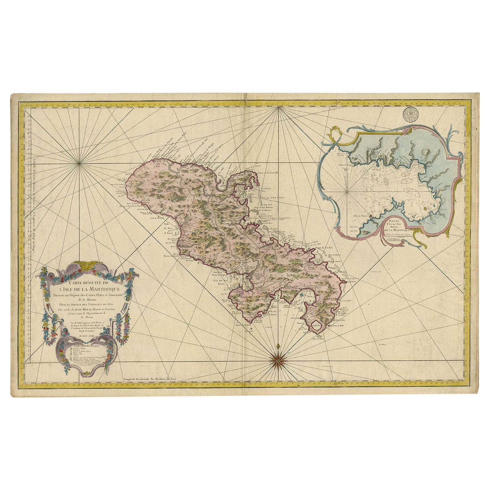
Stunning Large Scale Antique Map of Martinique, Rare, Published 1758
Located in Langweer, NL
Antique map titled 'Carte Reduite de l'Isle de la Martinique Dressee au Depost des Cartes Plans et Journaux de la Marine.'
Superb, large scale chart of th...
Category
Antique 18th Century Maps
Materials
Paper
$2,021 Sale Price
30% Off
Free Shipping
Original Antique Map of Southern Asia, Published in 1833
Located in Langweer, NL
Antique map titled 'Carte de l'Inde'. Detailed map extending from India in the west to Vietnam and the Malay Peninsula in the east. This map originates from 'Atlas universel de geogr...
Category
Antique Mid-19th Century Maps
Materials
Paper

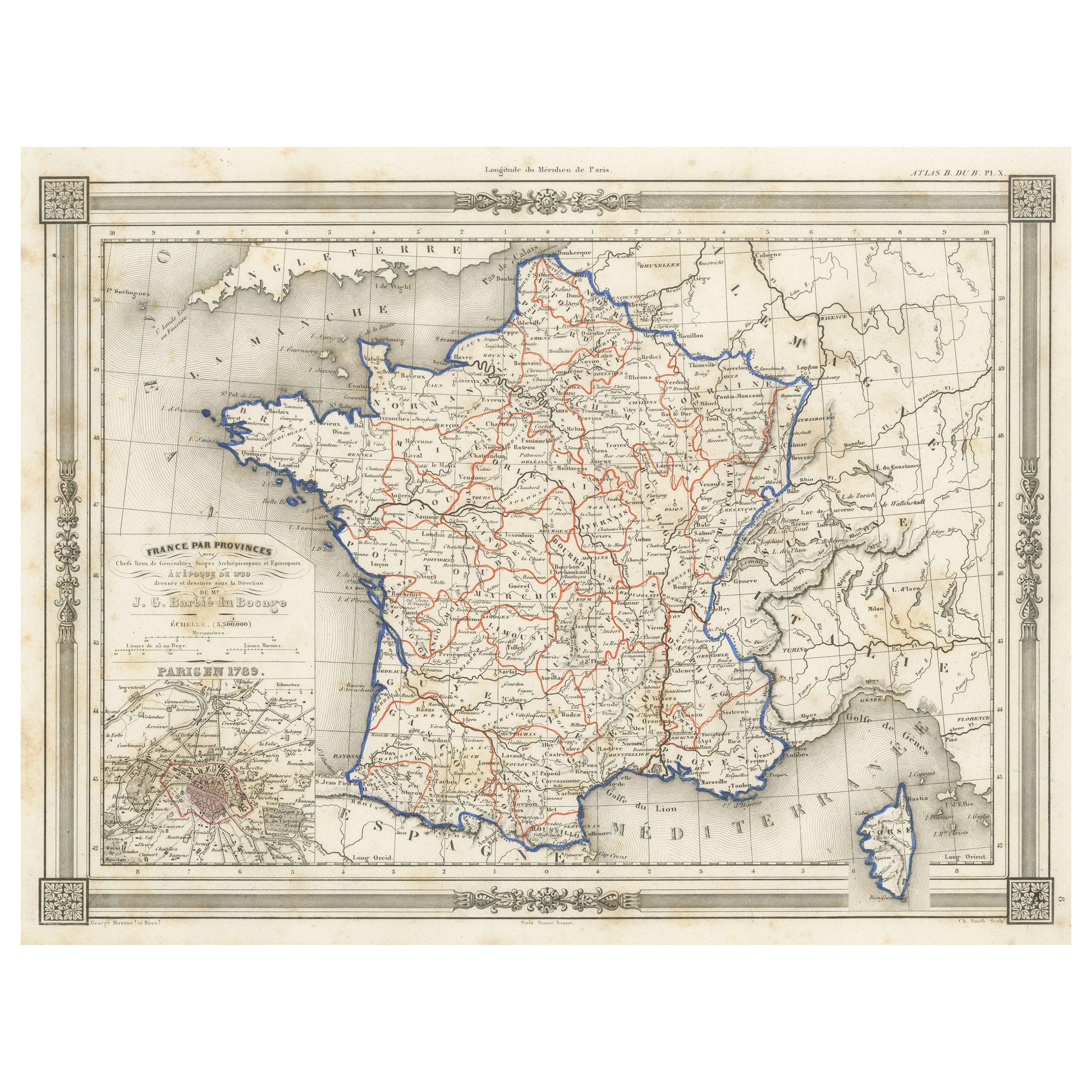
Antique Map of France in Provinces, with Inset of Paris
Located in Langweer, NL
Antique map titled 'France par Provinces'. Original antique map of France in Provinces. It covers from the Flanders in the north to Roussillon in the south and from Brittany in the w...
Category
Antique Mid-19th Century Maps
Materials
Paper

You May Also Like
French 1930s Map of Paris à Vol d'Oiseau under Glass in Custom Iron Frame
Located in Atlanta, GA
A French map of Paris from the early 20th century, with custom iron frame. Created in Paris during the second quarter of the 20th century, this map of Paris à vol d'oiseau (as the Cr...
Category
Early 20th Century French Prints
Materials
Iron
Antique Map of Paris, "Carte Routiere des Environs de Paris" 1841
Located in Colorado Springs, CO
This beautiful hand-colored road map of Paris was published in 1841. The map shows Paris and the surrounding area in a folding pocket map. Organized and detailed for travelers, this ...
Category
Antique 1840s French Maps
Materials
Paper

Vintage "View of the Center of Paris Taken from the Air" Lithograph Map
Located in San Diego, CA
A very stylish "View of the Center of Paris Taken from the Air" lithograph map published by the Paris Ministry of Tourism, circa early 1950s. The piece measures 27" x 43" and shows...
Category
20th Century French Mid-Century Modern Prints
Materials
Paper

$680 Sale Price
20% Off
Large French Paris Metro Map 1960s
Located in North Hollywood, CA
Large French Paris Metro Map 1960s.
A large Vintage French framed map of the Parisian Metro from the mid-20th century.
Featuring a Paris metro map from the midcentury period showing ...
Category
Mid-20th Century French Industrial Prints
Materials
Wood, Paper
Antique Map of Principality of Monaco
By Antonio Vallardi Editore
Located in Alessandria, Piemonte
ST/619 - "Old Geographical Atlas of Italy - Topographic map of ex-Principality of Monaco" -
ediz Vallardi - Milano -
A somewhat special edition ---
Category
Antique Late 19th Century Italian Other Prints
Materials
Paper

Map of the Republic of Genoa
Located in New York, NY
Framed antique hand-coloured map of the Republic of Genoa including the duchies of Mantua, Modena, and Parma.
Europe, late 18th century.
Dimension: 25...
Category
Antique Late 18th Century European Maps

Recently Viewed
View AllMore Ways To Browse
Curved Bar Cart
Delft Tiles
Dining Chairs S8
Dutch Green Glass
Dux Swedish Chair
English Reading Table
English Style Arm Chairs
English Walnut Armchair
Etched Glass Coffee Table
Etched Silver Tray
Federal Style Banded
Finn Juhl 1949 Chair
Five By Five Marble Table
Fold Over Game Table
Folding Wood Dining Chairs
Franco Albini Pair Chairs
French 18th Century Louis Xvi Chair
French Arm Chairs Fining