Items Similar to Large 1778 Lotter World Map - Ovoid Projection with Captain Cook's Voyage Routes


Want more images or videos?
Request additional images or videos from the seller
1 of 8
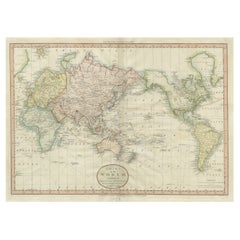
Large 1778 Lotter World Map - Ovoid Projection with Captain Cook's Voyage Routes
About the Item
Title: 1778 Lotter World Map - Ovoid Projection with Captain Cook's First Voyage Routes
Description: This rare 1778 map, "Mappe Monde ou Carte Generale de L'Univers," was published in Augsburg by Matthäus Albrecht Lotter. It features a unique ovoid projection based on J.B.B. d'Anville's 1761 wall map. The map includes detailed geographic names, political boundaries, and the routes of Captain James Cook's first voyage (1768-1771), a pivotal exploration that expanded European knowledge of the Pacific and Australasia.
Hand-colored and engraved by Georg Friedrich Lotter, this map exemplifies 18th-century cartographic craftsmanship, blending scientific representation with elegant design. The Lotter family, a renowned cartographic dynasty, created this map during the European Enlightenment, when geography and discovery were central to intellectual and artistic pursuits.
Additional Information: What makes this map interesting:
This 1778 map, "Mappe Monde ou Carte Generale de L'Univers," by Matthäus Albrecht Lotter, is notable for its unique ovoid projection, a departure from more traditional map projections of the time. Based on J.B.B. d'Anville’s 1761 wall map, it incorporates the latest geographical knowledge of the 18th century, particularly focusing on Captain James Cook’s first voyage (1768–1771). Cook's route is meticulously charted, reflecting the European fascination with exploration and discovery during the Enlightenment.
The map highlights important places and regions such as Europe, Africa, Asia, the Americas, and the Pacific Ocean. It includes references to newly discovered lands and maritime routes, emphasizing the expansion of geographic knowledge. The inclusion of Terra Australis (Australia) and detailed representations of Polynesian islands showcases the influence of Cook's voyages on cartography. The map also features historical locations such as New Holland (Australia), the Cape of Good Hope, and the Arctic regions.
The Lotter family, with Matthäus Albrecht Lotter as the publisher and Georg Friedrich Lotter as the engraver, was part of a prominent cartographic dynasty based in Augsburg, Germany. Their work represents a blend of artistic elegance and scientific accuracy, characteristic of European cartography in the 18th century.
This map's connection to maritime history, its aesthetic appeal, and its depiction of global exploration make it a sought-after piece for collectors. Its hand-colored detail adds to its visual charm and historical significance, capturing the spirit of an era when mapping the world was both an art and a science.
Details:
- Publisher: Matthäus Albrecht Lotter, Augsburg, 1778
- Projection: Ovoid (elliptical)
- Features: Includes Cook’s voyage, detailed geography, hand-coloring
- Size: Large format map suitable for framing or display
Condition The map is in good condition with vibrant hand-coloring. Marginal wear is consistent with its age. This example is free from significant tears or stains, preserving its historical integrity and value.
This map is a valuable piece for collectors of maritime history, Enlightenment cartography, and decorative 18th-century maps. Its combination of artistic appeal and historical importance makes it an excellent addition to any collection.
Keywords: Captain Cook map, Lotter 1778 map, ovoid projection world map, Augsburg cartography, d'Anville-inspired maps, 18th-century map.
- Dimensions:Height: 25.6 in (65 cm)Width: 37.8 in (96 cm)Depth: 0.01 in (0.2 mm)
- Materials and Techniques:Paper,Engraved
- Period:1770-1779
- Date of Manufacture:1778
- Condition:Condition The map is in good condition with vibrant hand-coloring. Marginal wear is consistent with its age. This example is free from significant tears or stains, preserving its historical integrity and value.
- Seller Location:Langweer, NL
- Reference Number:Seller: BHZ675.jpg1stDibs: LU3054343446722
About the Seller
5.0
Recognized Seller
These prestigious sellers are industry leaders and represent the highest echelon for item quality and design.
Platinum Seller
Premium sellers with a 4.7+ rating and 24-hour response times
Established in 2009
1stDibs seller since 2017
2,417 sales on 1stDibs
Typical response time: <1 hour
- ShippingRetrieving quote...Shipping from: Langweer, Netherlands
- Return Policy
Authenticity Guarantee
In the unlikely event there’s an issue with an item’s authenticity, contact us within 1 year for a full refund. DetailsMoney-Back Guarantee
If your item is not as described, is damaged in transit, or does not arrive, contact us within 7 days for a full refund. Details24-Hour Cancellation
You have a 24-hour grace period in which to reconsider your purchase, with no questions asked.Vetted Professional Sellers
Our world-class sellers must adhere to strict standards for service and quality, maintaining the integrity of our listings.Price-Match Guarantee
If you find that a seller listed the same item for a lower price elsewhere, we’ll match it.Trusted Global Delivery
Our best-in-class carrier network provides specialized shipping options worldwide, including custom delivery.More From This Seller
View AllOld World Map Featuring Captain Cook's Exploration Routes and Polar Views, 1787
Located in Langweer, NL
1786 World Map with Polar Projections - "Globo Terrestre" by Giovanni Maria Cassini
This 1786 map titled "Globo Terrestre" by Giovanni Maria Cassini offers a fascinating and detai...
Category
Antique 1860s Maps
Materials
Paper
$1,764 Sale Price
20% Off
1778 Engraving: Captain Cook's Second Voyage - Meeting the Tahitians
Located in Langweer, NL
1778 Engraving of Captain Cook's Second Voyage: Meeting Tahitians
This beautiful copper-line engraving from 1778, created by Charles Grignion (1717-1810) after a work by Samuel Wale...
Category
Antique 1770s Prints
Materials
Paper
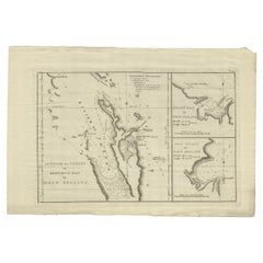
Detailed Map of New Zealand Showing the Route of Capt. Cook's First Voyage, 1803
Located in Langweer, NL
Antique map New Zealand titled 'De Rivier de Theems en Mercurius Baai in Nieuw Zeeland'. Detailed map of New Zealand showing the route of Capta...
Category
Antique 19th Century Maps
Materials
Paper
$528 Sale Price
30% Off
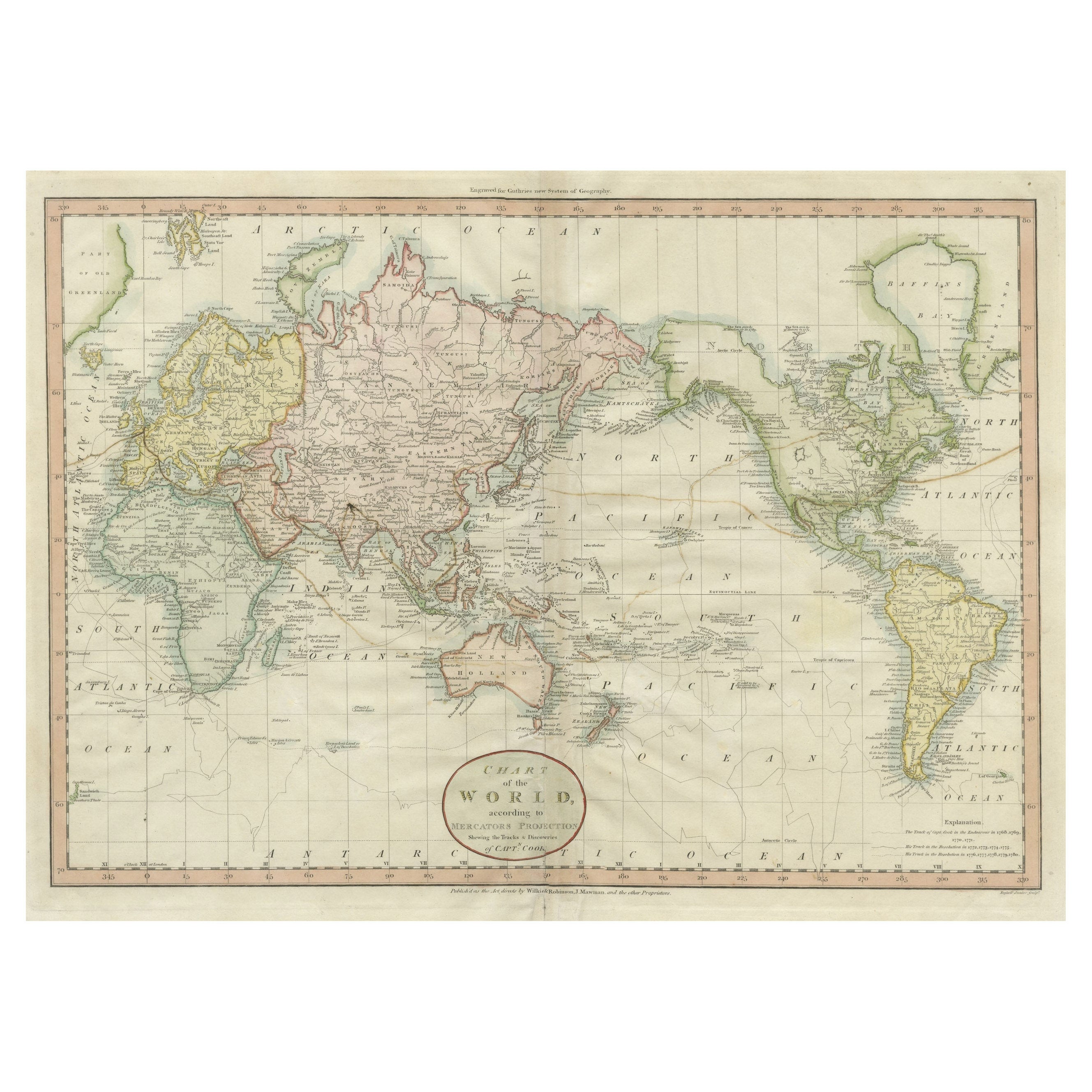
Very Attractive Antique Map of the World as Planisphere, Shows Cook's Voyages
Located in Langweer, NL
Antique map titled 'Chart of the World, according to Mercators Projection'. This world map shows the various discoveries of Captain James Cook during his 3 voyages between 1768 and 1780, and the English and French Explorers who followed immediately thereafter, including Vancouver and La Perouse. This edition of the map is significantly revised from the editions issued immediately after the official report of Cook's Voyages were integrated into the map, showing better detail in New Zealand, Australia, the Northwest Coast of America and North East coast of Asia, along with Greenland. A new large lake also appears for the first time in the Western part of North America, shortly before the commencement of the Lewis...
Category
Antique Late 18th Century Maps
Materials
Paper
$1,305 Sale Price
25% Off
Free Shipping
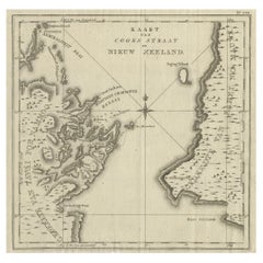
Antique Map of Cook's Strait in New Zealand, 1803
Located in Langweer, NL
Antique map New Zealand titled 'Kaart van Cooks Straat in Nieuw Zeeland'. Antique map of Cook's Strait in New Zealand. Originates from 'Reizen ...
Category
Antique 19th Century Maps
Materials
Paper
$603 Sale Price
20% Off
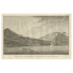
Captain Cook's Encampment in Australia where The Endeavour was Beached, 1803
Located in Langweer, NL
Antique print Australia titled 'Gezigt van de Rivier Endeavour op de Kust van Nieuw-Holland'.
View of an encampent on the shore of the Endeavour river on the coast of Australia where the Endeavour boat was beached. Originates from 'Reizen Rondom de Waereld door James Cook (..)'.
HMS Endeavour was a British Royal Navy research vessel that Lieutenant James Cook commanded to Australia and New Zealand on his first voyage of discovery from 1768 to 1771.
She was launched in 1764 as the collier Earl of Pembroke, with the Navy purchasing her in 1768 for a scientific mission to the Pacific Ocean and to explore the seas for the surmised Terra Australis Incognita or "unknown southern land". Commissioned as His Majesty's Bark Endeavour, she departed Plymouth in August 1768, rounded Cape Horn and reached Tahiti in time to observe the 1769 transit of Venus across the Sun. She then set sail into the largely uncharted ocean to the south, stopping at the islands of Huahine, Bora Bora, and Raiatea west of Tahiti to allow Cook to claim them for Great Britain. In September 1769, she anchored off New Zealand, becoming the first European vessel to reach the islands since Abel Tasman's Heemskerck 127 years earlier.
In April 1770, Endeavour became the first European ship to reach the east coast of Australia, with Cook going ashore at what is now known as Botany Bay. Endeavour then sailed north along the Australian coast. She narrowly avoided disaster after running aground on the Great Barrier Reef, and Cook had to throw her guns overboard to lighten her. Endeavour was beached on the Australian mainland for seven weeks to permit rudimentary repairs to her hull. Resuming her voyage, she limped into port in Batavia in October 1770, her crew sworn to secrecy about the lands that they had visited. From Batavia Endeavour continued westward, rounded the Cape of Good Hope on 13 March 1771 and reached the English port of Dover on 12 July, having been at sea for nearly three years.
The ship was largely forgotten after her Pacific voyage, spending the next three years hauling troops and cargo to and from the Falkland Islands. She was renamed in 1775 after being sold into private hands, and used to transport timber from the Baltic. Rehired as a British troop transport during the American War of Independence, she was finally scuttled in a blockade of Narragansett Bay, Rhode Island in 1778. Historical evidence indicates the ship was sunk just north of Goat Island in Newport Harbor, along with four other British transports.
Relics from Endeavour are displayed at maritime museums worldwide, including an anchor and six of her cannon. A replica of Endeavour was launched in 1994 and is berthed alongside the Australian National Maritime Museum in Sydney Harbour. The NASA Space Shuttle...
Category
Antique Early 1800s Prints
Materials
Paper
$508 Sale Price
40% Off
You May Also Like
Captain Cook's Exploration of Tahiti 18th C. Hand-Colored Map by Bellin
By Jacques-Nicolas Bellin
Located in Alamo, CA
This beautiful 18th century hand-colored copper plate engraved map is entitled "Carte de l'Isle de Taiti, par le Lieutenant J. Cook" was created by Jacques Nicolas Bellin and publish...
Category
Antique Mid-18th Century French Maps
Materials
Paper

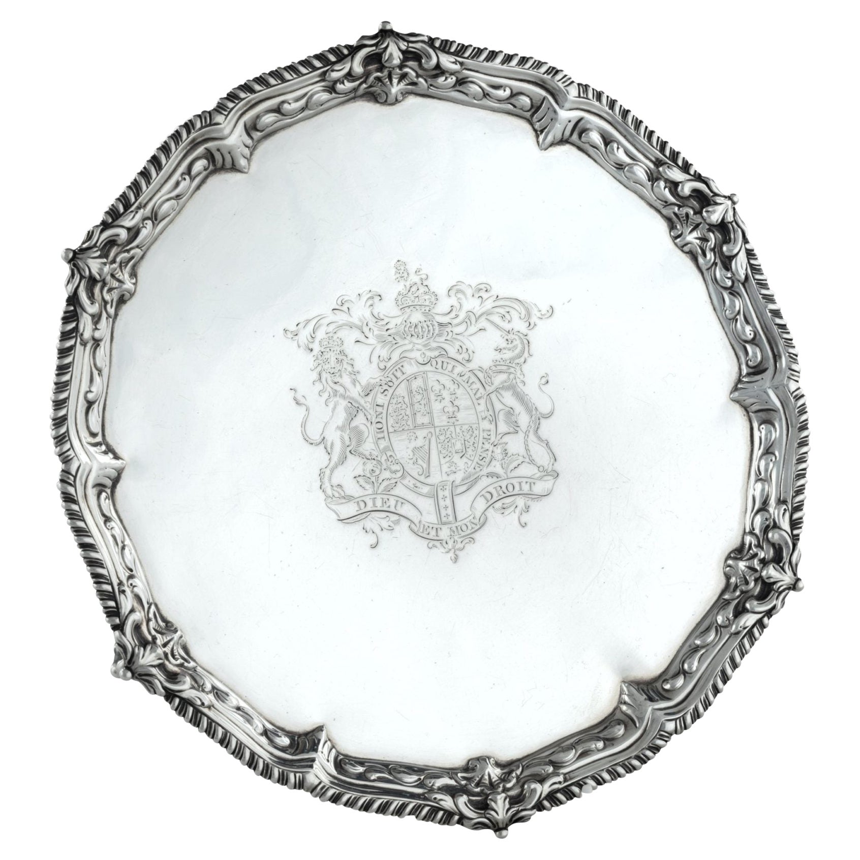
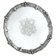
Presentation silver to the Master Shipwright of Captain Cook’s Endeavour
Located in Lymington, Hampshire
A George III shaped circular silver salver, plain within a shell and scrolling wave border and outer gadrooned edge, engraved with the royal coat of arms, crest and motto (period 1714-1800) of King George III and, on the reverse with a presentation inscription: For the Launching of His Majestys sloop ‘Otter’ 14 Gunns 305 Tonns 26 October 1767 & His Majestys ship ‘Egmont’ 74 Gunns 1643 Tonns 29 August 1768 by Mr Adam Hayes Master Shipwright of his Majestys yard at Deptford; further monogrammed A*H P A*M. Hallmarked for Benjamin Cartwright, London, 1769
Adam Hayes (1710-1785) began his career as ship’s carpenter in Centurion during Commodore Anson’s famous voyage around the world...
Category
Antique 1760s English George III Nautical Objects
Materials
Silver
1864 Johnson's Map of the World on Mercator's Projection, Ric.B009
Located in Norton, MA
An 1864 Johnson's map of
the World on Mercator's Projection
Ric.b009
About this Item
"This antique map came from Johnson's New Illustrated (Steel Plate) Family Atlas, publ...
Category
Antique 19th Century Dutch Maps
Materials
Paper
Large Scale Antique Scroll Map of Lincolnshire, England, Dated 1778
Located in St Annes, Lancashire
Wonderful scroll map of Lincolnshire
By Captain Armstrong, 1778
Copper plate engraving on paper laid on canvas
Original ebonized wood frame with lovely t...
Category
Antique 1770s English Georgian Maps
Materials
Wood, Paper

$760 Sale Price
84% Off
Free Shipping
World Relief Map
Located in Antwerp, BE
Large world relief map.
Measures: Width 232 cm.
Height 158 cm.
Category
Mid-20th Century German Mid-Century Modern Maps
Materials
Acrylic

$2,089
Large Original Antique Map of The World, Fullarton, C.1870
Located in St Annes, Lancashire
Great map of the World. Showing both hemispheres
From the celebrated Royal Illustrated Atlas
Lithograph. Original color.
Published by Fullarton, Edinburgh, C.1870
Unframed.
Rep...
Category
Antique 1870s Scottish Maps
Materials
Paper

Recently Viewed
View AllMore Ways To Browse
Cape Dutch Furniture
Scientific Wall Chart
Polynesian Wall
Science Charts
French Coffee Bowl
French Salon Sofa
Fruit Knife
Furniture By Donghia
Genuine Sheepskin
German Colored Crystal Glass
Gilt Wall Sculpture Large
Glass Berry Bowl
Glass Mosaic Tile Wall Art
Hammock Designs
Hand Blown Glass Tumbler
Hand Blown Tumblers
Hand Painted Sugar Bowl
Industrial Sofa Three Seater