Items Similar to Imperial Splendor: Antique Map of the Ottoman Empire by Blaeu, circa 1640


Want more images or videos?
Request additional images or videos from the seller
1 of 6
Imperial Splendor: Antique Map of the Ottoman Empire by Blaeu, circa 1640
About the Item
The antique map titled 'Turcicum Imperium' is an original old map of the Ottoman Empire, historically and colloquially known as the Turkish Empire. Here are the key features and details of the map:
1. **Geographic Coverage**:
- The map covers a vast expanse of territory, extending from Sicily and Italy in the west to the Black and Caspian Seas in the north, and from the Gulf of Aden, Red Sea, and the Arabian Peninsula in the south.
- The central focus of the map is on Cyprus, which serves as a prominent point of reference.
2. **Cartouche**:
- The map features a particularly fine cartouche, which is a decorative element often used in maps to frame and highlight important information.
- In this cartouche, an elaborate depiction of the Turkish Sultan seated on his throne can be seen. This represents the central authority of the Ottoman Empire.
- Allegorical figures are present on either side of the cartouche, brandishing weapons. These figures may symbolize the strength and military prowess of the empire.
3. **Sailing Ships**:
- The map includes depictions of sailing ships in both the Arabian Sea and the Mediterranean. This likely reflects the importance of maritime trade and naval activities in the region.
4. **Geographical Accuracy**:
- For its time, the map provides reasonably accurate geographical details, including the names of many place names.
- Notable locations mentioned on the map include Armenia and George (Giorgia), highlighting the extent of the Ottoman Empire's territory.
5. **Publisher**:
- The map was published by Blaeu, a well-known Dutch cartographer and publisher, circa 1640. The Blaeu family was renowned for producing high-quality maps during the 17th century.
6. **Historical Significance**:
- This map is historically significant as it offers insights into the extent and power of the Ottoman Empire during the 17th century.
- It serves as a valuable artifact for understanding the geopolitical landscape of the time, including the empire's influence in the Mediterranean and beyond.
7. **Aesthetics**:
- The map is described as impressive and attractive, reflecting the artistry and craftsmanship of mapmaking during the period.
In summary, the 'Turcicum Imperium' antique map provides a visual representation of the vast Ottoman Empire during the 17th century. It combines historical, geographic, and artistic elements to create a visually striking and informative map that offers a window into the geopolitical landscape of the time.
- Dimensions:Height: 17.33 in (44 cm)Width: 21.54 in (54.7 cm)Depth: 0.02 in (0.5 mm)
- Materials and Techniques:Paper,Engraved
- Period:Mid-17th Century
- Date of Manufacture:c.1640
- Condition:Repaired: Original folding line with repair. Several other repairs on small tears, corners and top margin. Shows toning and soiling. Blank verso. Please study image carefully.
- Seller Location:Langweer, NL
- Reference Number:Seller: BG-133981stDibs: LU3054333645272
About the Seller
5.0
Recognized Seller
These prestigious sellers are industry leaders and represent the highest echelon for item quality and design.
Platinum Seller
Premium sellers with a 4.7+ rating and 24-hour response times
Established in 2009
1stDibs seller since 2017
2,415 sales on 1stDibs
Typical response time: 1 hour
- ShippingRetrieving quote...Shipping from: Langweer, Netherlands
- Return Policy
Authenticity Guarantee
In the unlikely event there’s an issue with an item’s authenticity, contact us within 1 year for a full refund. DetailsMoney-Back Guarantee
If your item is not as described, is damaged in transit, or does not arrive, contact us within 7 days for a full refund. Details24-Hour Cancellation
You have a 24-hour grace period in which to reconsider your purchase, with no questions asked.Vetted Professional Sellers
Our world-class sellers must adhere to strict standards for service and quality, maintaining the integrity of our listings.Price-Match Guarantee
If you find that a seller listed the same item for a lower price elsewhere, we’ll match it.Trusted Global Delivery
Our best-in-class carrier network provides specialized shipping options worldwide, including custom delivery.More From This Seller
View AllAntique Map of the Spice Islands 'Moluccas', Indonesia by W. Blaeu, circa 1640
By Willem Blaeu
Located in Langweer, NL
Antique map titled 'Moluccae Insulae Celeberrimae'. Highly decorative antique map of the Spice Islands (Moluccas) published by W. Blaeu (circa 1640). This map features a large inset ...
Category
Antique Mid-17th Century Maps
Materials
Paper

Antique Map of the Region of Le Mans 'France' by Blaeu, circa 1640
By Willem Blaeu
Located in Langweer, NL
Antique Map: Cenomanorum Galliae regionis typus vulgo le Mans – Blaeu, circa 1640
This beautifully engraved and hand-colored map depicts the historical province of Maine in northw...
Category
Antique Mid-17th Century Maps
Materials
Paper

$462 Sale Price
20% Off
Free Shipping
Antique Map of Catalonia by Blaeu, circa 1650
Located in Langweer, NL
Antique map titled 'Catalonia'. Antique map of Catalonia, extending from C. De Romani on the Northern Coast to Alfachs and Panicola in Valencia on the southern end of the coast and s...
Category
Antique Mid-17th Century Maps
Materials
Paper

Antique Map of Prussia by Blaeu, circa 1635
By Willem Blaeu
Located in Langweer, NL
Antique map titled 'Prussiae Nova Tabula'. Rare early edition of Blaeu's map of Prussia, embellished with a gorgeous large format cartouche, compass ros...
Category
Antique Mid-17th Century Maps
Materials
Paper

$665 Sale Price
20% Off
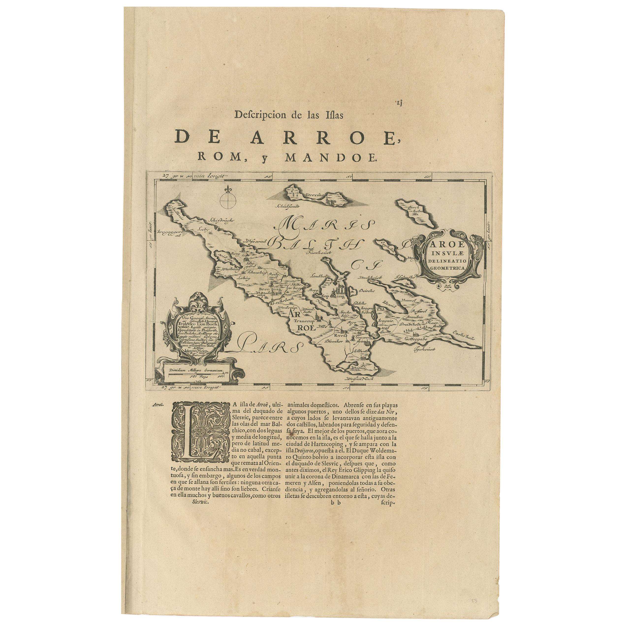
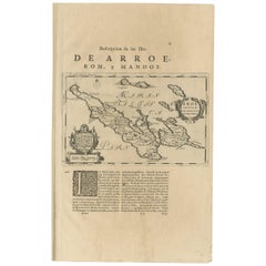
Antique Map of Aero by Blaeu, 'circa 1670'
Located in Langweer, NL
Antique map titled 'Aroe Insulae delineatio geometrica'. Old map of Aero, a small Danish island in the Baltic Sea. This map originates from a Spanish edition of 'Atlas Maior' by J. B...
Category
Antique Mid-17th Century Maps
Materials
Paper
Antique Map of the Region of Blois by Janssonius, 'circa 1640'
By Johannes Janssonius
Located in Langweer, NL
Antique map titled 'Description du Blaisois'. Old map of the region of Blois, France. It shows the city of Blois, Amboise, the Loire River and more. Published by J. Janssonius, circa...
Category
Antique Mid-17th Century Maps
Materials
Paper

You May Also Like
Antique Map Of Lovanium By Bleau Circa 1640
Located in Brussels, Brussels
map of the brabent of leuven (Belgium) circa 1640 by Bléau. Bléau was well known for antique atlas that he draw during the 17 century
beautiful map, double page folded in the middle,...
Category
Antique 17th Century French Renaissance Prints
Materials
Paper
Original Antique Map of The World by Thomas Clerk, 1817
Located in St Annes, Lancashire
Great map of The Eastern and Western Hemispheres
On 2 sheets
Copper-plate engraving
Drawn and engraved by Thomas Clerk, Edinburgh.
Published by Mackenzie And Dent, 1817
...
Category
Antique 1810s English Maps
Materials
Paper

Original Antique Map of Spain and Portugal, circa 1790
Located in St Annes, Lancashire
Super map of Spain and Portugal
Copper plate engraving by A. Bell
Published, circa 1790.
Unframed.
Category
Antique 1790s English Other Maps
Materials
Paper

Map of the Republic of Genoa
Located in New York, NY
Framed antique hand-coloured map of the Republic of Genoa including the duchies of Mantua, Modena, and Parma.
Europe, late 18th century.
Dimension: 25...
Category
Antique Late 18th Century European Maps

Antique Map of Italy by Andriveau-Goujon, 1843
By Andriveau-Goujon
Located in New York, NY
Antique Map of Italy by Andriveau-Goujon, 1843. Map of Italy in two parts by Andriveau-Goujon for the Library of Prince Carini at Palazzo Carini i...
Category
Antique 1840s French Maps
Materials
Linen, Paper

$3,350 / set
Antique Map of Principality of Monaco
By Antonio Vallardi Editore
Located in Alessandria, Piemonte
ST/619 - "Old Geographical Atlas of Italy - Topographic map of ex-Principality of Monaco" -
ediz Vallardi - Milano -
A somewhat special edition ---
Category
Antique Late 19th Century Italian Other Prints
Materials
Paper

Recently Viewed
View AllMore Ways To Browse
T1 Side Table
Tiger Antique Carpets
Tribal Tuareg Rug
Velvet Fruit
Vintage Barware Collectibles
Vintage Educational Prints
Vintage Metal Umbrella Stand
Vintage Tea Tray Serving Trays
Vintage Tureen With Lid
Vintage Vitra Eames
Vintage Wooden Extendable Table
Whimsical Coffee Table
Wing Chair 1950s
Wormley For Dunbar Side Tables
Writing Desk With Fluted Legs
16th Century Antique Tapestry
18th Century Silver Spoon
1960s Vintage Club Chair