Items Similar to Historical Map of Canaan with Insets of Jerusalem and Surrounding Regions, 1880


Want more images or videos?
Request additional images or videos from the seller
1 of 8
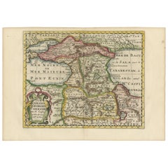
Historical Map of Canaan with Insets of Jerusalem and Surrounding Regions, 1880
About the Item
The map titled "CANAAN" depicts the historical region known as Canaan, located in the Levant, which corresponds to modern-day Israel, Palestinian territories, Lebanon, and parts of Syria and Jordan.
Key features include:
1. **Historical Territories**: It details the territories of the ancient Canaanite people and the subsequent Israelite tribes.
2. **Geographical Features**: The map shows the eastern Mediterranean coastline, the Jordan River, the Dead Sea, and other significant topographical features like mountain ranges and valleys.
3. **Inset Maps**: There are inset maps that provide a detailed view of important locations, such as Jerusalem, with key historical and biblical sites marked.
4. **Ancient Cities**: Cities such as Jericho, Hebron, and others are likely indicated, reflecting their importance in ancient times.
5. **Cultural and Political Boundaries**: The boundaries of the map might reflect the political divisions during different periods, such as the time of the Canaanites, the Judges, or the united and divided monarchy of Israel.
6. **Archaeological and Historical Sites**: The map may also mark locations of archaeological significance or areas mentioned in biblical and historical texts.
This map would hold interest for those studying the ancient Near East, biblical history, archaeology, and the historical geography of the region. It represents the area during a period that could range from the late Bronze Age to the Iron Age when Canaan was a hub of various cultural and political activities.
This map is from the "Spruner-Menke Atlas Antiquus," a historical atlas compiled by German cartographer Karl Spruner von Merz and later edited by Theodorus Menke. The atlas is known for its detailed maps of the ancient world, intended for educational and scholarly use, and was published in the late 19th century.
- Dimensions:Height: 15.56 in (39.5 cm)Width: 18.51 in (47 cm)Depth: 0 in (0.02 mm)
- Materials and Techniques:
- Period:
- Date of Manufacture:1880
- Condition:Good, given age. General age-related toning, especially around the edges. vertical folding line as issued. Please study scan carefully.
- Seller Location:Langweer, NL
- Reference Number:Seller: BG-13686-2-221stDibs: LU3054338557692
About the Seller
5.0
Recognized Seller
These prestigious sellers are industry leaders and represent the highest echelon for item quality and design.
Platinum Seller
Premium sellers with a 4.7+ rating and 24-hour response times
Established in 2009
1stDibs seller since 2017
2,415 sales on 1stDibs
Typical response time: 1 hour
- ShippingRetrieving quote...Shipping from: Langweer, Netherlands
- Return Policy
Authenticity Guarantee
In the unlikely event there’s an issue with an item’s authenticity, contact us within 1 year for a full refund. DetailsMoney-Back Guarantee
If your item is not as described, is damaged in transit, or does not arrive, contact us within 7 days for a full refund. Details24-Hour Cancellation
You have a 24-hour grace period in which to reconsider your purchase, with no questions asked.Vetted Professional Sellers
Our world-class sellers must adhere to strict standards for service and quality, maintaining the integrity of our listings.Price-Match Guarantee
If you find that a seller listed the same item for a lower price elsewhere, we’ll match it.Trusted Global Delivery
Our best-in-class carrier network provides specialized shipping options worldwide, including custom delivery.More From This Seller
View AllHistorical Map of the Black Sea and Surrounding Regions, 1705
Located in Langweer, NL
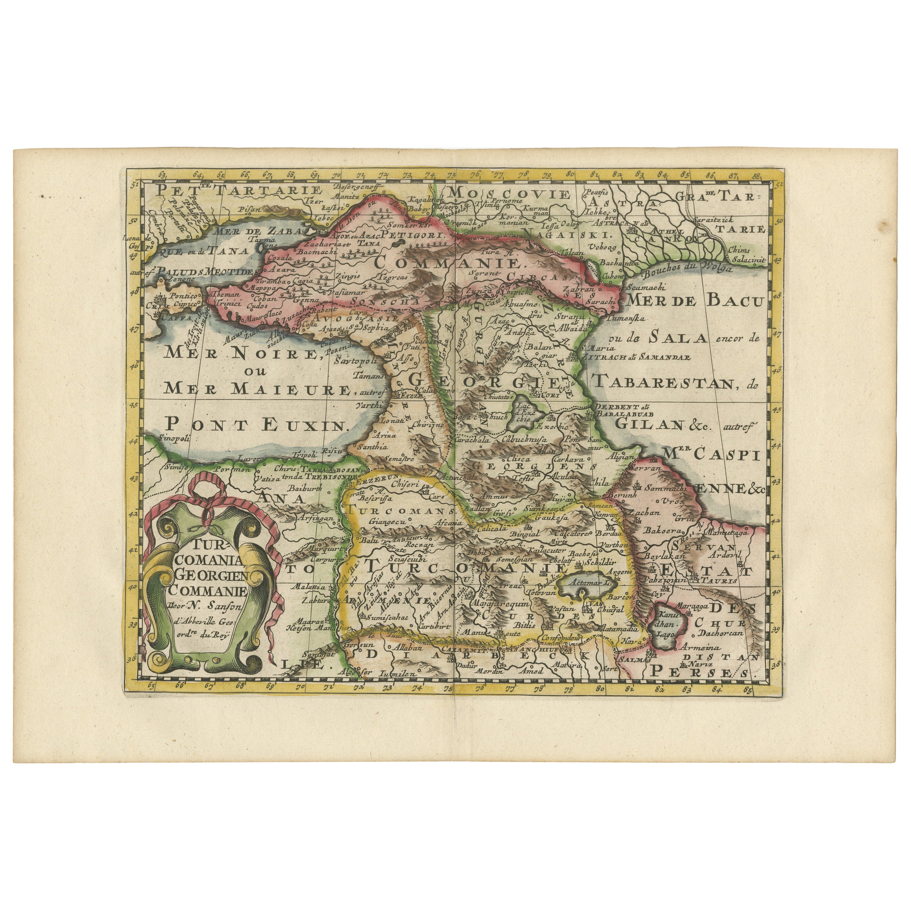
Title: "Map of Turcomania, Georgia, and Comania"
This print presents an intricately detailed map of the Caucasus region, titled “Turcomania, Georgien Commanie,” by the esteemed cart...
Category
Antique Early 1700s Maps
Materials
Paper
Antique Map of Champagne and surrounding Regions, France
Located in Langweer, NL
Antique map titled 'Carte de la Champagne et des Pays Voisins (..)'. Detailed map of Champagne and surrounding regions of Chalons and Soissons, Reims,...
Category
Antique Mid-18th Century Maps
Materials
Paper

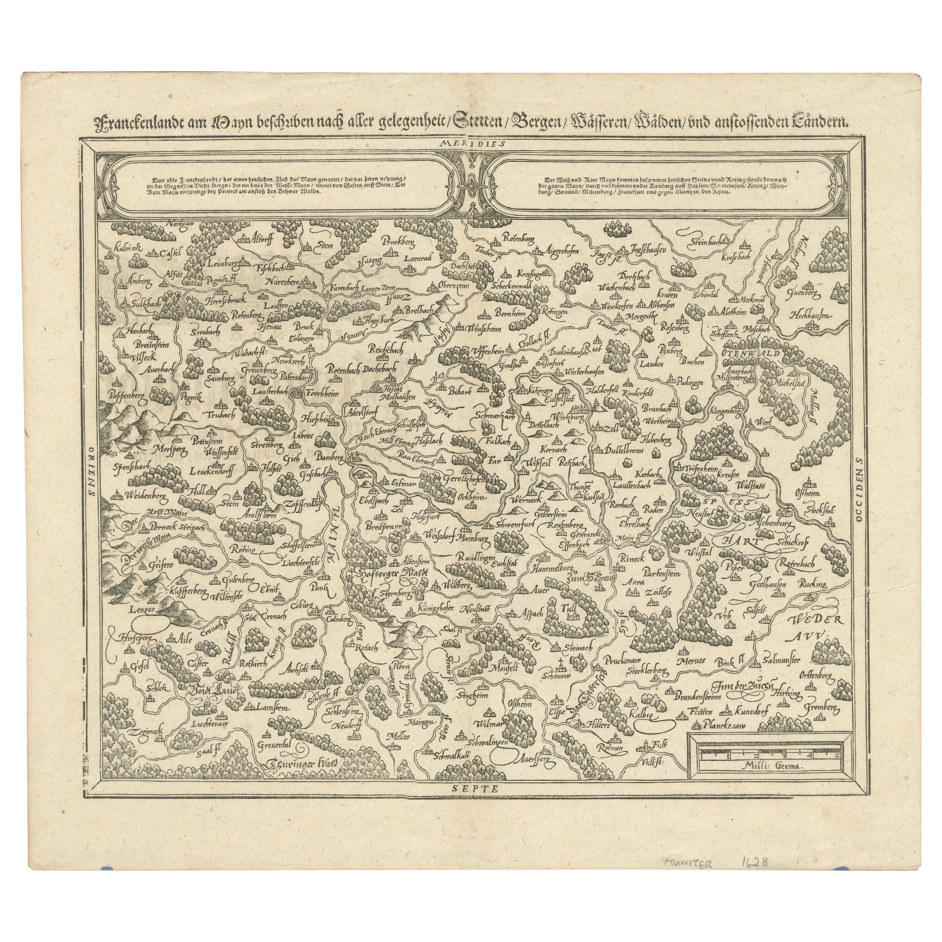
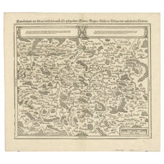
Early Woodcut Map of Franconia and Surrounding Regions, 1628
Located in Langweer, NL
Title: Early Woodcut Map of Franconia and Surrounding Regions, 1628
Franconia (Franckenlande) is a region in Germany. Historically, Franconia was a significant part of the Holy Roma...
Category
Antique 1620s Maps
Materials
Paper
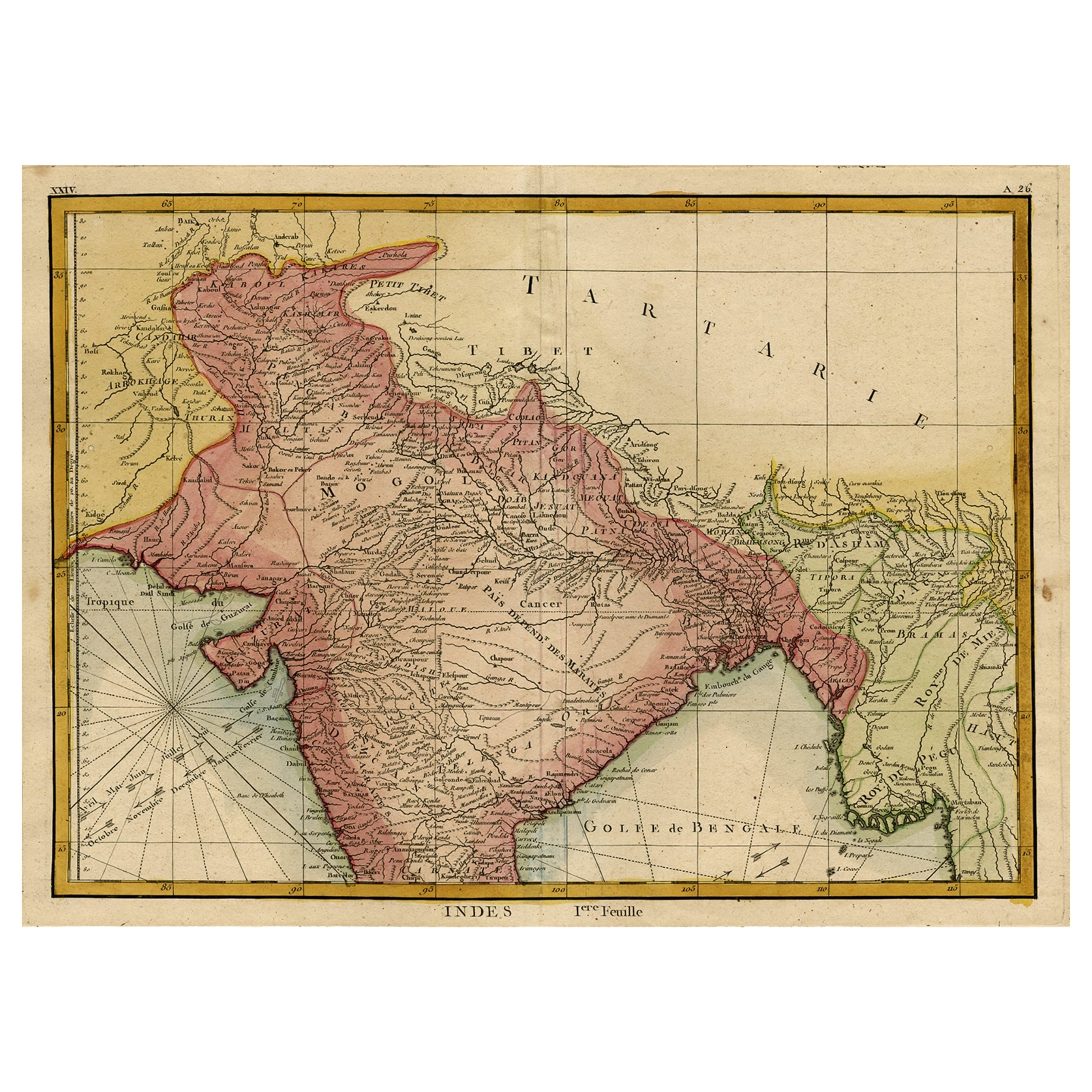
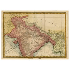
Original and Colourful Map of Northern India with Surrounding Regions, 1783
Located in Langweer, NL
Antique map titled 'Indes'. A map of Northern India with surrounding regions. From Lattre's 'Atlas moderne ou collection de cartes sur toutes les parties du globe terrestre...
Category
Antique 1780s Maps
Materials
Paper
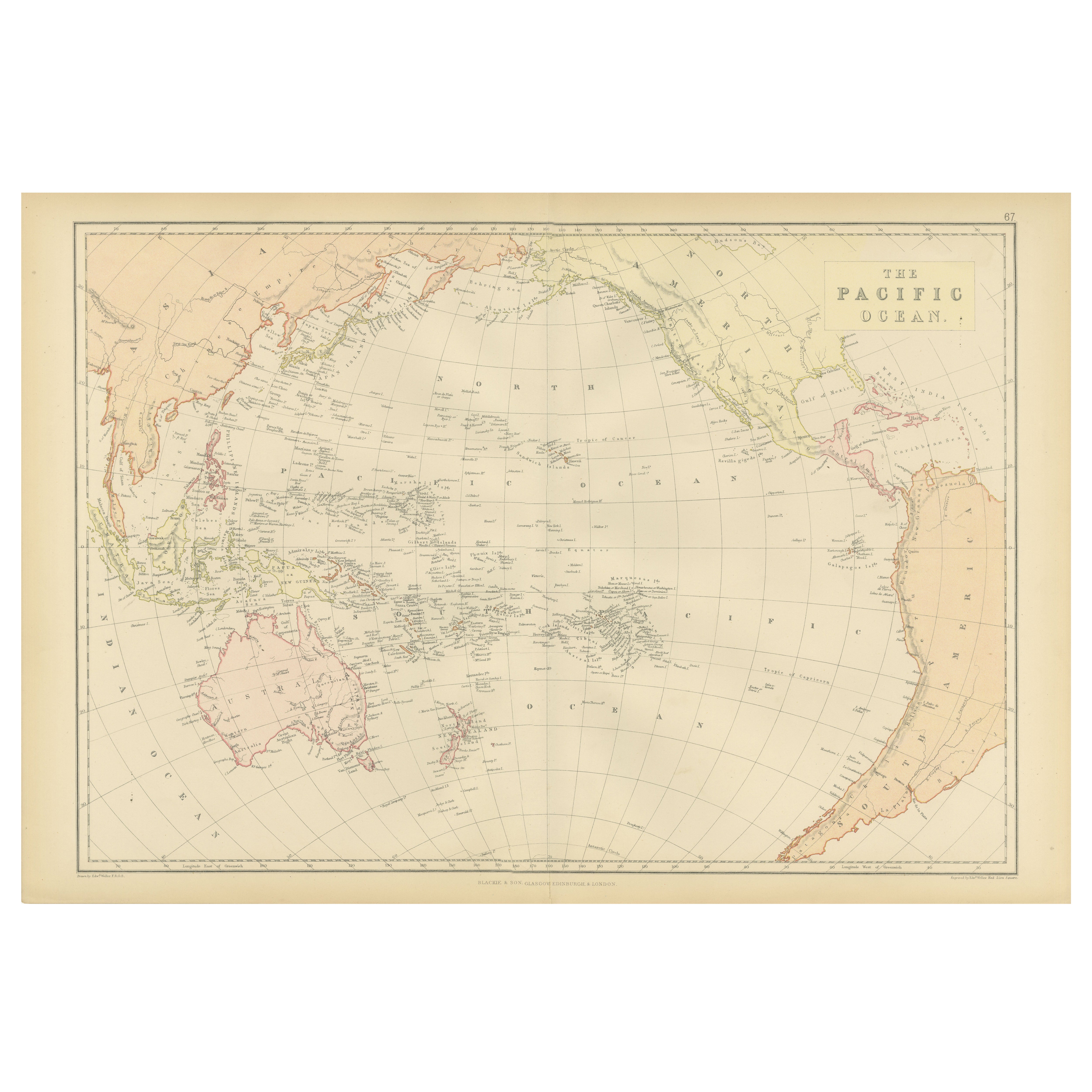
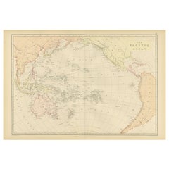
1882 Map of the Pacific Ocean Highlighting Islands and Surrounding Regions
Located in Langweer, NL
This 1882 map of the Pacific Ocean, published by Blackie and Son as part of the 'Comprehensive Atlas and Geography of the World,' presents a detailed and fascinating overview of the ...
Category
Antique 1880s Maps
Materials
Paper
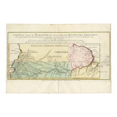
Map of the Amazon River's Course and Surrounding Regions (1743-1744)
Located in Langweer, NL
This original antique map, titled "Carte du Cours du Maragnon ou de la Grande Riviere des Amazones," illustrates the course of the Amazon River (referred to here as the Maragnon) fro...
Category
Antique 1750s Maps
Materials
Paper
You May Also Like
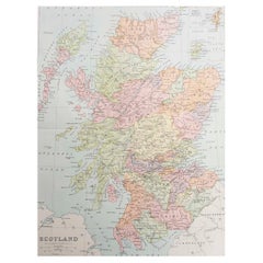
Original Antique Map of Scotland. Circa 1880
Located in St Annes, Lancashire
Great map of Scotland
Drawn and Engraved by J.Bartholomew
Published C.1880
Original colour
Unframed.
Category
Antique 1880s English Maps
Materials
Paper
Map Holy Promise Land Canaan Richard Palmer Richard Blome 1687 Joseph Moxon
Located in BUNGAY, SUFFOLK
Canaan comonly called the Holy Land or the Land of Promise, being the Possesion of the Israelites & travelled through by Our Lord & Saviour Iesus Christ and his Apostles. Engraven by Richard Palmer for Richard Blome. 1687
Blome, Richard, 1641-1705. London. 283 x 452 mm. Copperplate.
Probably from an English Bible...
Category
Antique 17th Century British Baroque Maps
Materials
Paper

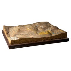
French topographic embossed map in three dimensions of ancient Jerusalem - 19th
Located in Bruxelles, BE
French topographic embossed map in three dimensions of Ancient Jerusalem
19th century
wood and hand-coloured plaster
10,5 x 43 x 58 cm
Provenance : Private collection UK
Wood and ...
Category
Antique 19th Century French Belle Époque Models and Miniatures
Materials
Plaster, Wood
Persia, Armenia & Adjacent Regions: A 17th Century Hand-colored Map by De Wit
By Frederick de Wit
Located in Alamo, CA
A large 17th century hand colored copperplate engraved map entitled "Novissima nec non Perfectissima Scandinaviae Tabula comprehendens Regnorum Sueciae, Daniae et Norvegiae distincte...
Category
Antique Late 17th Century Dutch Maps
Materials
Paper

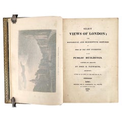
Select Views of London, With Historical and Descriptive Sketches - Ackermann
Located in Middletown, NY
A SPLENDID DEPICTION of REGENCY LONDON
Papworth, John Buonarotti
Select Views of London: With Historical and Descriptive Sketches of Some of the Most Interesting of Its Public Build...
Category
Antique Early 19th Century English Books
Materials
Leather, Paint, Paper
Large Original Antique Map of the Environs of Cork, Ireland, circa 1880
Located in St Annes, Lancashire
Great map of The Environs of Cork
Published circa 1880
Unframed
Free shipping.
Category
Antique 1880s Scottish Maps
Materials
Paper

Recently Viewed
View AllMore Ways To Browse
Antique Ancient Key
Jordan 6
Antique Furniture Lebanon
19th Century Carpet Bag
3 Piece Sterling Silver Tea Set
48 Round Coffee Table
7 Foot Sofa
Antique Cherry Chair
Antique Mason Plates
Antique Measuring Jugs
Antique Red Trunk
Antique Table 4 Drawers
Antique Work Stool
Antique Yolk
Art Nouveau Silver Overlay
Axe Table
Ball And Claw Chippendale Chair
Baroque Writing Desk