Items Similar to Hand Colored Antique Map of the Department of Creuse, France

Want more images or videos?
Request additional images or videos from the seller
1 of 6
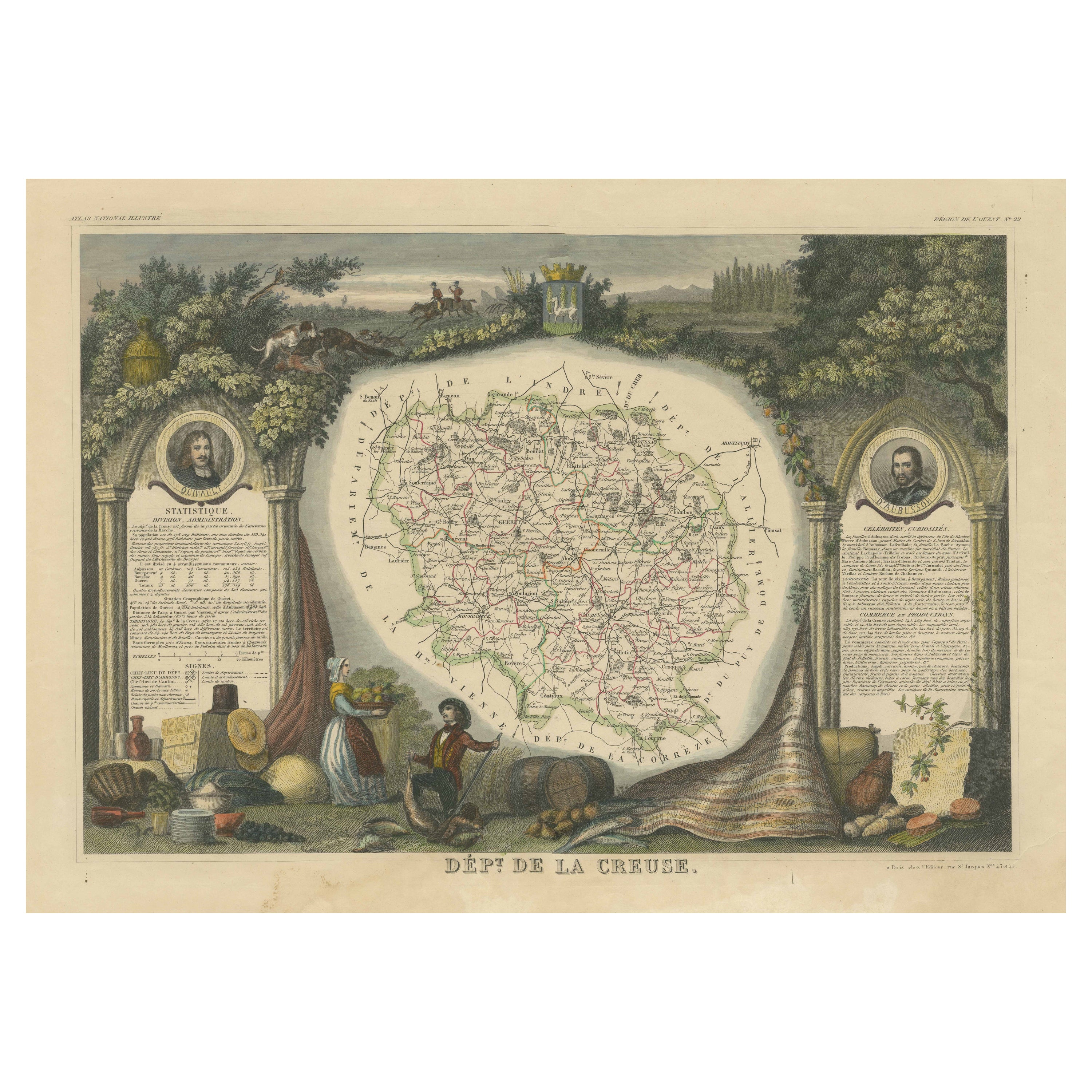
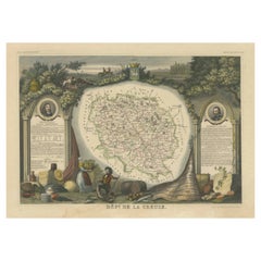
Hand Colored Antique Map of the Department of Creuse, France
About the Item
Antique map titled 'Dépt. de la Creuse'. Map of the French department of Creuse, France. This region is well known for its apple cider made from Limousin apples and its internationally renowned Limousine beef. The whole is surrounded by elaborate decorative engravings designed to illustrate both the natural beauty and trade richness of the land. There is a short textual history of the regions depicted on both the left and right sides of the map.
This map originates from 'Atlas National de la France Illustree' published by V. Levasseur, circa 1852.
Victor Levasseur (1800–1870) was a French cartographer widely known for his distinctive decorative style. He produced numerous maps more admired for the artistic content of the scenes and data surrounding the map than for the detail of the map. Victor Levasseur's "Atlas National Illustré" and "Atlas Universel Illustré" are among the last great decorative atlases published.
- Creator:Victor Levasseur (Artist)
- Dimensions:Height: 14.41 in (36.6 cm)Width: 20.28 in (51.5 cm)Depth: 0.02 in (0.5 mm)
- Materials and Techniques:
- Period:
- Date of Manufacture:circa 1852
- Condition:Wear consistent with age and use. General age-related toning. Shows some wear and soiling, blank verso. Few small tears/splits in margins. Please study images carefully.
- Seller Location:Langweer, NL
- Reference Number:Seller: BG-13216-131stDibs: LU3054331464242

Victor Levasseur
Victor Jules Levasseur (1795–1862) was a French cartographer widely known for his distinctive decorative style. He produced numerous maps more admired for the artistic content of the scenes and data surrounding the map than for the detail of the map. Victor Levasseur was born in 1795 in France. Little is known about his early life and education, but he emerged as one of the most prominent French cartographers of the 19th century. Levasseur lived during a time of significant political and geographical changes in France and Europe, which greatly influenced his work as a mapmaker.
About the Seller
5.0
Recognized Seller
These prestigious sellers are industry leaders and represent the highest echelon for item quality and design.
Platinum Seller
Premium sellers with a 4.7+ rating and 24-hour response times
Established in 2009
1stDibs seller since 2017
2,417 sales on 1stDibs
Typical response time: <1 hour
- ShippingRetrieving quote...Shipping from: Langweer, Netherlands
- Return Policy
Authenticity Guarantee
In the unlikely event there’s an issue with an item’s authenticity, contact us within 1 year for a full refund. DetailsMoney-Back Guarantee
If your item is not as described, is damaged in transit, or does not arrive, contact us within 7 days for a full refund. Details24-Hour Cancellation
You have a 24-hour grace period in which to reconsider your purchase, with no questions asked.Vetted Professional Sellers
Our world-class sellers must adhere to strict standards for service and quality, maintaining the integrity of our listings.Price-Match Guarantee
If you find that a seller listed the same item for a lower price elsewhere, we’ll match it.Trusted Global Delivery
Our best-in-class carrier network provides specialized shipping options worldwide, including custom delivery.More From This Seller
View AllOld Map of the French department of Creuse, France
By Victor Levasseur
Located in Langweer, NL
Antique map titled 'Dépt. de la Creuse'. Map of the French department of Creuse, France. This region is well known for its apple cider made from Limousin apples and its international...
Category
Antique Mid-19th Century Maps
Materials
Paper
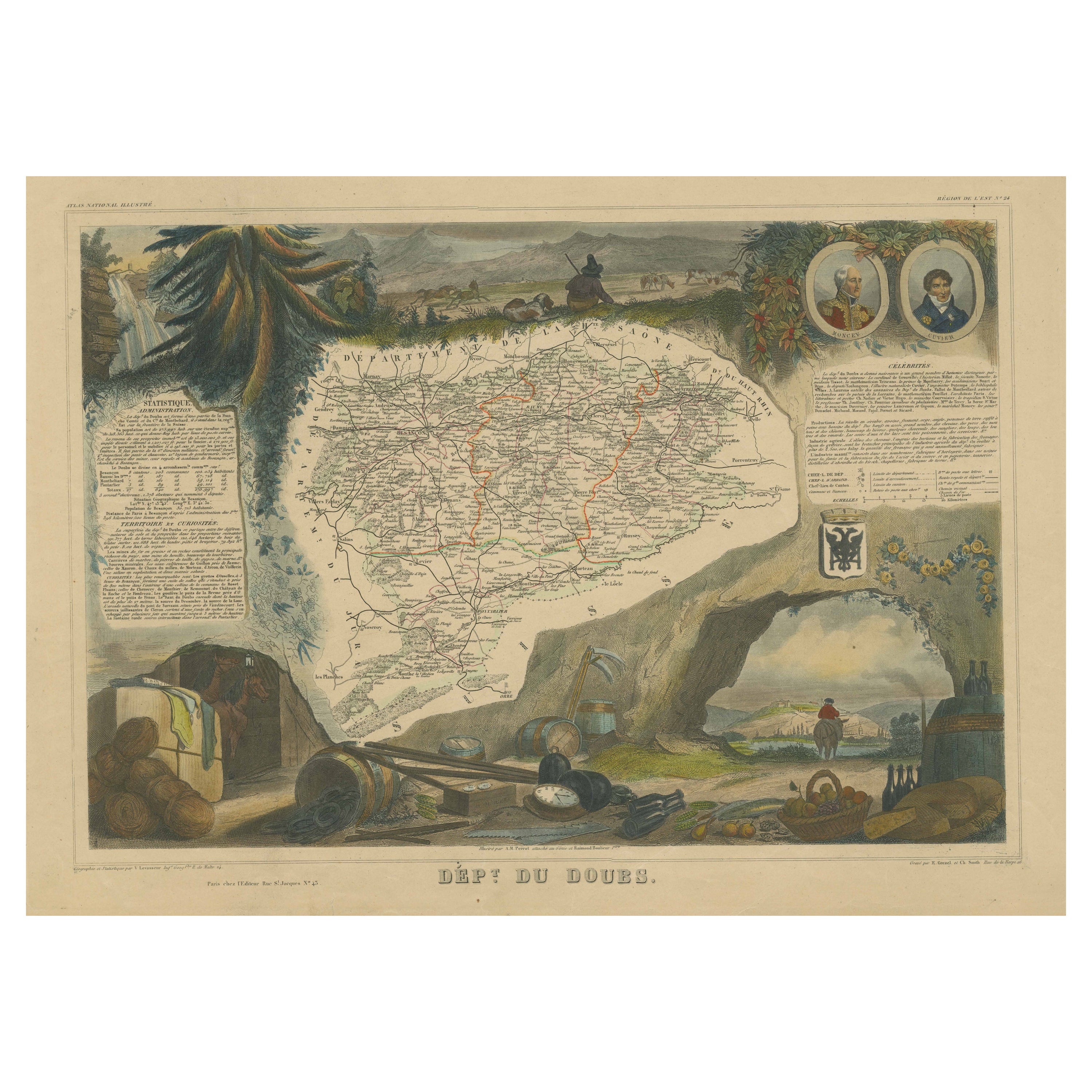
Hand Colored Antique Map of the Department of Doubs, France
By Victor Levasseur
Located in Langweer, NL
Antique map titled 'Dépt. du Doubs'. Map of the French department of Doubs, France. The whole is surrounded by elaborate decorative engravings designed to illustrate both the natural...
Category
Antique Mid-19th Century Maps
Materials
Paper
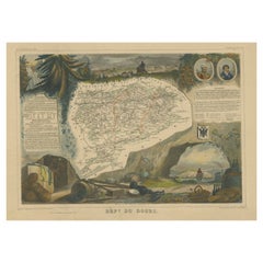
$197 Sale Price
50% Off
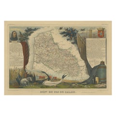
Hand Colored Antique Map of the Department of Calais, France
By Victor Levasseur
Located in Langweer, NL
Antique map titled 'Dépt. du Pas de Calais'. Map of the French department of Calais, France. This area is known for producing Maroilles, a soft cheese made from cow’s milk and with a...
Category
Antique Mid-19th Century Maps
Materials
Paper
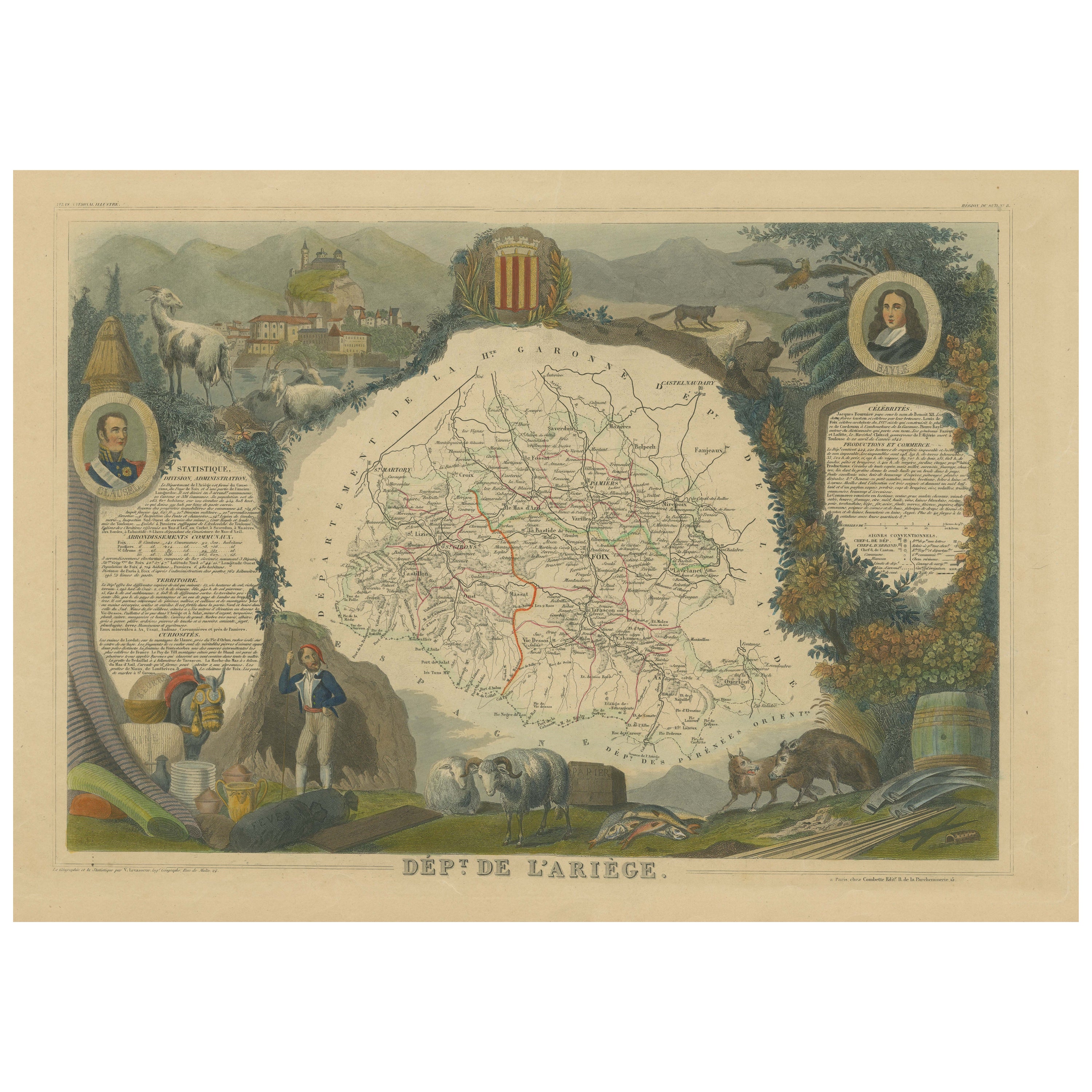
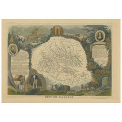
Hand Colored Antique Map of the Department of Ariège, France
By Victor Levasseur
Located in Langweer, NL
Antique map titled 'Dépt. de l'Ariège'. Map of the French department of Ariege, France. This area of France is known for its production of semi-soft and mild cheeses, such as Bethmal...
Category
Antique Mid-19th Century Maps
Materials
Paper
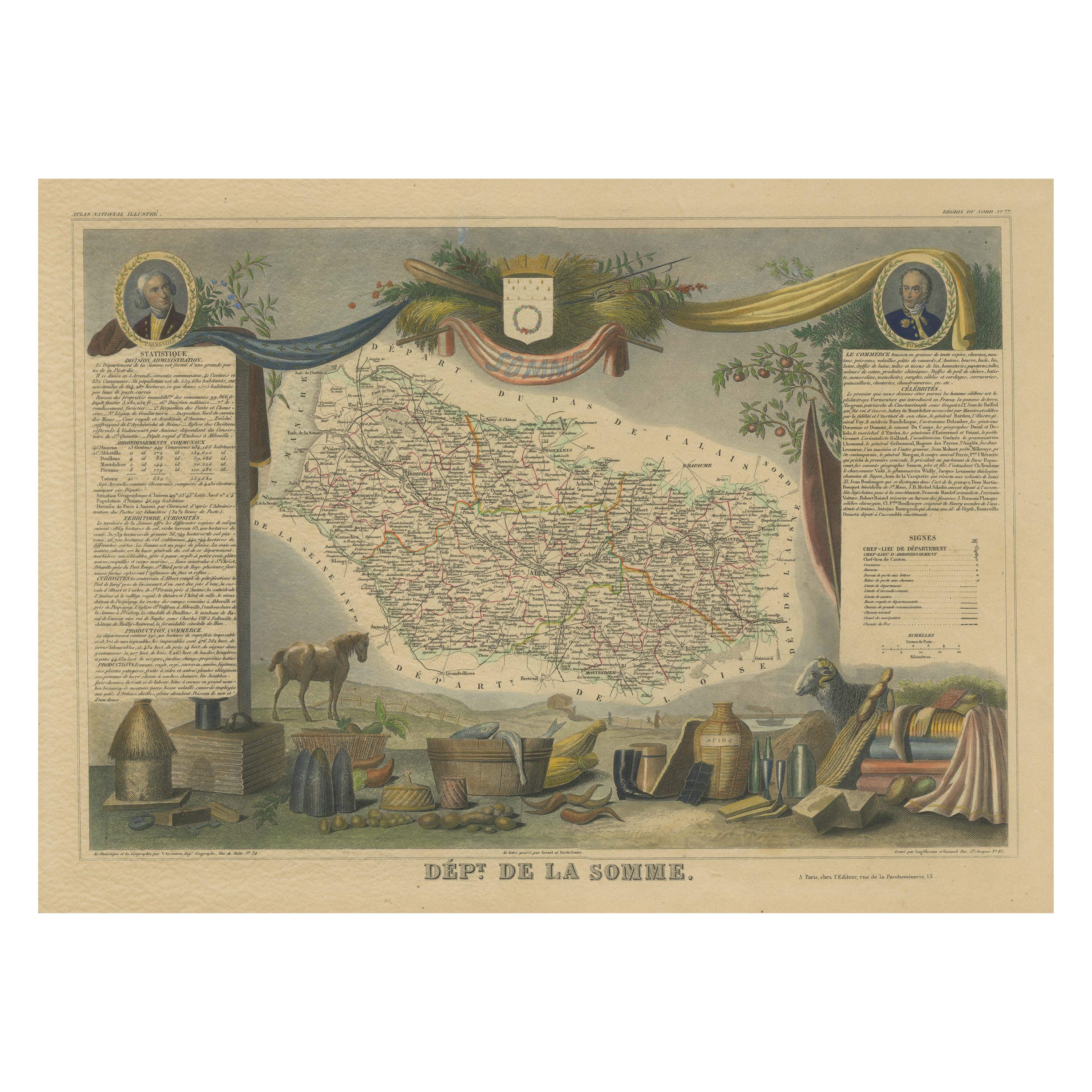
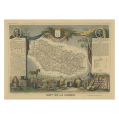
Hand Colored Antique Map of the department of Somme, France
By Victor Levasseur
Located in Langweer, NL
Antique map titled 'Dépt de la Somme'. Map of the French department of Somme, France. This area is home to the region of Picardy, which produces Maroilles, a popular French cheese. T...
Category
Antique Mid-19th Century Maps
Materials
Paper
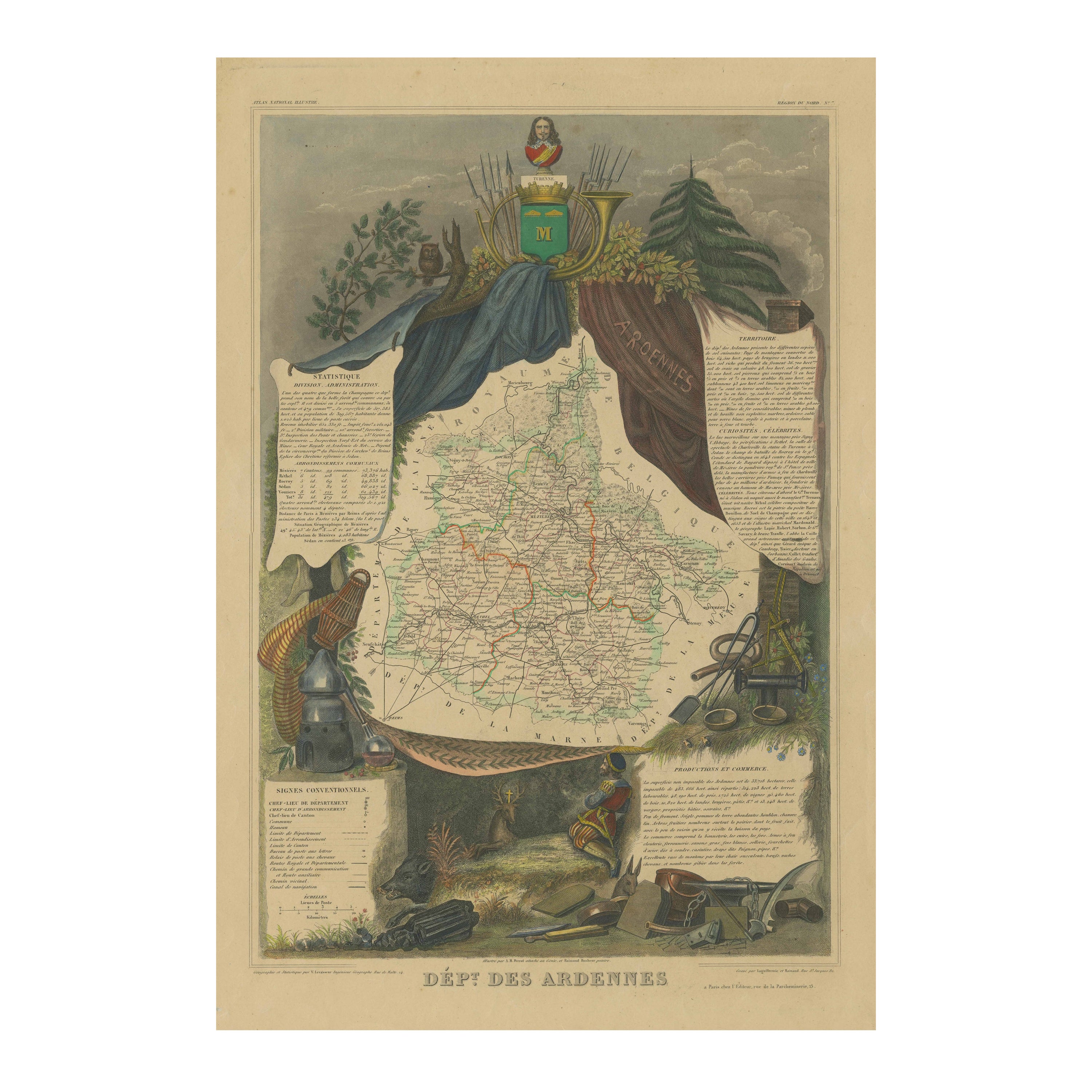
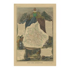
Hand Colored Antique Map of the department of Ardennes, France
By Victor Levasseur
Located in Langweer, NL
Antique map titled 'Dépt. des Ardennes'. Map of the French department of Ardennes, France. Part of France's important Champagne producing region. The whole is surrounded by elaborate...
Category
Antique Mid-19th Century Maps
Materials
Paper
You May Also Like
The Normandy Region of France: A 17th C. Hand-colored Map by Sanson and Jaillot
By Nicolas Sanson
Located in Alamo, CA
This large hand-colored map entitled "Le Duché et Gouvernement de Normandie divisée en Haute et Basse Normandie en divers Pays; et par evêchez, avec le Gouvernement General du Havre ...
Category
Antique 1690s French Maps
Materials
Paper

Hand-Colored 18th Century Homann Map of the Danube, Italy, Greece, Croatia
By Johann Baptist Homann
Located in Alamo, CA
"Fluviorum in Europa principis Danubii" is a hand colored map of the region about the Danube river created by Johann Baptist Homann (1663-1724) in his 'Atlas Novus Terrarum', publish...
Category
Antique Early 18th Century German Maps
Materials
Paper

Hand Colored 18th Century Homann Map of Austria Including Vienna and the Danube
By Johann Baptist Homann
Located in Alamo, CA
"Archiducatus Austriae inferioris" is a hand colored map of Austria created by Johann Baptist Homann (1663-1724) and published in Nuremberg, Germany in 1728 shortly after his death. ...
Category
Antique Early 18th Century German Maps
Materials
Paper

The Kingdom of Naples and Southern Italy: A Hand-Colored 18th Century Homann Map
By Johann Baptist Homann
Located in Alamo, CA
"Novissima & exactissimus Totius Regni Neapolis Tabula Presentis Belli Satui Accommo Data" is a hand colored map of southern Italy and the ancient Kingdom of Naples created by Johann...
Category
Antique Early 18th Century German Maps
Materials
Paper

17th Century Hand Colored Map of the Liege Region in Belgium by Visscher
By Nicolaes Visscher II
Located in Alamo, CA
An original 17th century map entitled "Leodiensis Episcopatus in omnes Subjacentes Provincias distincté divisusVisscher, Leodiensis Episcopatus" by Nicolaes Visscher II, published in Amsterdam in 1688. The map is centered on Liege, Belgium, includes the area between Antwerp, Turnhout, Roermond, Cologne, Trier and Dinant.
This attractive map is presented in a cream-colored mat measuring 30" wide x 27.5" high. There is a central fold, as issued. There is minimal spotting in the upper margin and a tiny spot in the right lower margin, which are under the mat. The map is otherwise in excellent condition.
The Visscher family were one of the great cartographic families of the 17th century. Begun by Claes Jansz Visscher...
Category
Antique Late 17th Century Dutch Maps
Materials
Paper

Hand-Colored 18th Century Homann Map of Denmark and Islands in the Baltic Sea
By Johann Baptist Homann
Located in Alamo, CA
An 18th century copper plate hand-colored map entitled "Insulae Danicae in Mari Balthico Sitae utpote Zeelandia, Fionia, Langelandia, Lalandia, Falstria, Fembria Mona" created by Joh...
Category
Antique Early 18th Century German Maps
Materials
Paper

Recently Viewed
View AllMore Ways To Browse
Large Neutral Oushak Rugs
Louis Xv Style Side Tables With Marble Top
Lustre China
Madsen Leather Chair
Maison Jansen Stamped
Manchester Wool
Marcel Gascoin C Chair
Matching Loveseats
Mcguire Furniture Vintage
Medal Medallions
Metal Reclining Chair
Mid Century Glass Decanter Bottles
Mid Century Gondola
Mid Century Italian Wood Arm Chair
Mid Century Modern Pull Out Desk
Mid Century Vintage Day Bed
Midcentury Modern Dining Chairs Chrome And Black Leather
Modern Pouffe