Items Similar to French Colonies in the Caribbean: Maps of Martinique and Guadeloupe (1852)

Want more images or videos?
Request additional images or videos from the seller
1 of 6
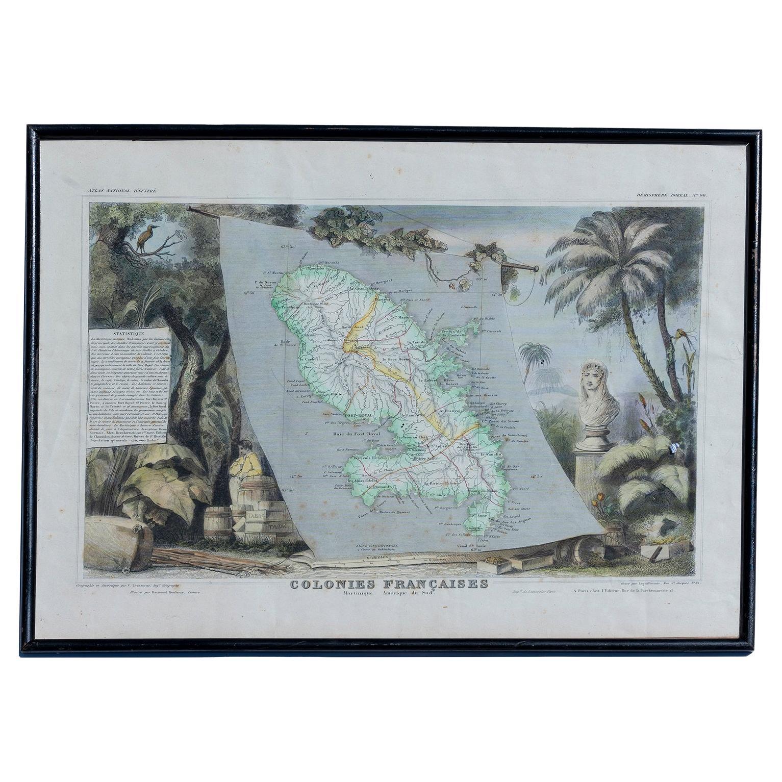
French Colonies in the Caribbean: Maps of Martinique and Guadeloupe (1852)
About the Item
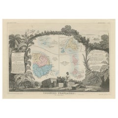
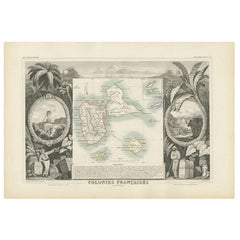
This pair of maps, published in 1852, provides a detailed representation of the French Caribbean colonies, specifically Martinique and Guadeloupe. They were part of the *Atlas Universel Illustré*, which presented not only maps but also artistic elements, highlighting aspects of the culture and history of the depicted regions.
Each map is surrounded by intricate engravings of tropical flora, fauna, and colonial life, offering a glimpse into the agricultural economy, including sugar and tobacco production, which played a vital role in the French colonies. Busts of notable figures and plantation scenes add to the historical significance of these prints.
The map of Martinique illustrates the island’s main roads, towns, and topography, while the Guadeloupe map, including neighboring islands, features similar details, helping viewers understand the geography and importance of these colonies in mid-19th century French expansion.
These maps not only served as geographical guides but also acted as political and economic statements, emphasizing France's colonial presence and the valuable resources found in these territories. The borders are hand-coloured.
- Dimensions:Height: 14.18 in (36 cm)Width: 21.26 in (54 cm)Depth: 0 in (0.02 mm)
- Sold As:Set of 2
- Materials and Techniques:Paper,Engraved
- Period:
- Date of Manufacture:1852
- Condition:Condition: good, given age. Overall light foxing. General age-related toning and/or occasional minor defects from handling. Please study scan carefully.
- Seller Location:Langweer, NL
- Reference Number:Seller: BG-13618-7 and BG-13618-81stDibs: LU3054341731472
About the Seller
5.0
Recognized Seller
These prestigious sellers are industry leaders and represent the highest echelon for item quality and design.
Platinum Seller
Premium sellers with a 4.7+ rating and 24-hour response times
Established in 2009
1stDibs seller since 2017
2,417 sales on 1stDibs
Typical response time: <1 hour
- ShippingRetrieving quote...Shipping from: Langweer, Netherlands
- Return Policy
Authenticity Guarantee
In the unlikely event there’s an issue with an item’s authenticity, contact us within 1 year for a full refund. DetailsMoney-Back Guarantee
If your item is not as described, is damaged in transit, or does not arrive, contact us within 7 days for a full refund. Details24-Hour Cancellation
You have a 24-hour grace period in which to reconsider your purchase, with no questions asked.Vetted Professional Sellers
Our world-class sellers must adhere to strict standards for service and quality, maintaining the integrity of our listings.Price-Match Guarantee
If you find that a seller listed the same item for a lower price elsewhere, we’ll match it.Trusted Global Delivery
Our best-in-class carrier network provides specialized shipping options worldwide, including custom delivery.More From This Seller
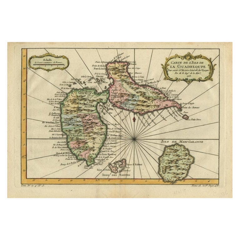
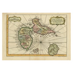
View AllAntique Map of Guadeloupe, Island in the Caribbean, c.1757
Located in Langweer, NL
Antique map titled 'Carte de L'Isle de la Guadeloupe'.
A very decorative map of Guadeloupe in the Caribbean, adorned with rhumb lines, fleur-de-lys, and two decorative rococo-style...
Category
Antique 18th Century Maps
Materials
Paper
$612 Sale Price
20% Off
Antique Map of Algeria and the French Colonies, 1875
Located in Langweer, NL
Antique map titled 'Algérie et Colonies Francaises'. Large map of Algeria and the French Colonies. This map originates from 'Atlas de Géographie Moderne Physique et Politique' by A. ...
Category
Antique Late 19th Century Maps
Materials
Paper

$232 Sale Price
50% Off
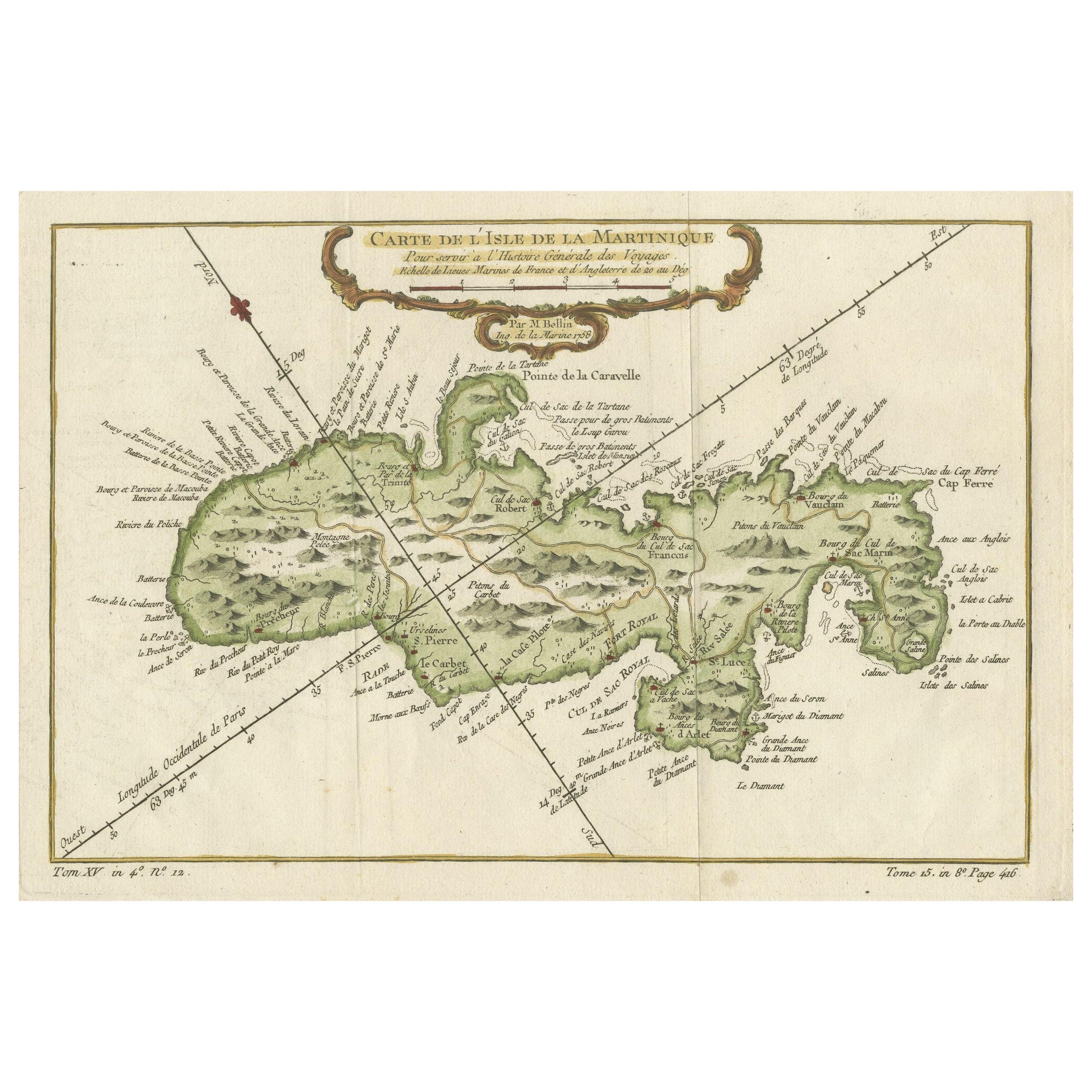
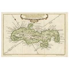
Martinique Island in the Caribbean by Bellin Original Original Antique Map, 1780
Located in Langweer, NL
This mid-18th century map, "Carte de l'Isle de la Martinique pour servir a l'historie generale des voyages," was issued in 1780 by M. Bellin in Paris. It presents a detailed and visually captivating depiction of the Island of Martinique within the context of the Caribbean and the Lesser Antilles.
**Title:** Carte de l'Isle de la Martinique pour servir a l'historie generale des voyages
**Issuer:** M. Bellin
**Date:** 1780
**Location Coverage:** North America, Caribbean, Martinique, Lesser Antilles
This engraved map is notable for its pleasing aesthetics, featuring lovely hand coloring that enhances its visual appeal. The inclusion of a scroll cartouche, an ornamental frame, and measurement lines adds a distinctive and visually appealing quality to the map.
Martinique, situated within the Lesser Antilles in the Caribbean, is presented with meticulous detail, showcasing geographical features, coastlines, settlements, and other notable landmarks. Bellin, known for his accuracy in cartography, crafted this map to serve as a geographical reference within the broader context of historical voyages and exploration.
The combination of detailed cartographic information and artistic embellishments, such as hand coloring and decorative elements, makes this map not only a valuable geographical document but also a visually pleasing piece of cartographic art...
Category
Antique Late 18th Century Maps
Materials
Paper
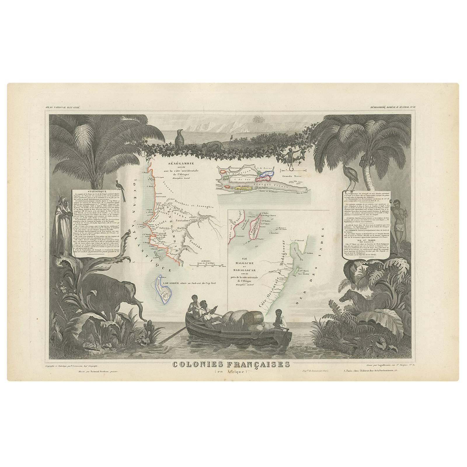
Antique Map of the French Colonies in Senegal and Madagascar by V. Levasseur
By Victor Levasseur
Located in Langweer, NL
The antique map titled 'Colonies Françaises (en Afrique)' presents a decorative depiction of the French colonies located in Senegal and Madagascar within Africa. Surrounding the map ...
Category
Antique Mid-19th Century Maps
Materials
Paper
$185 Sale Price
20% Off
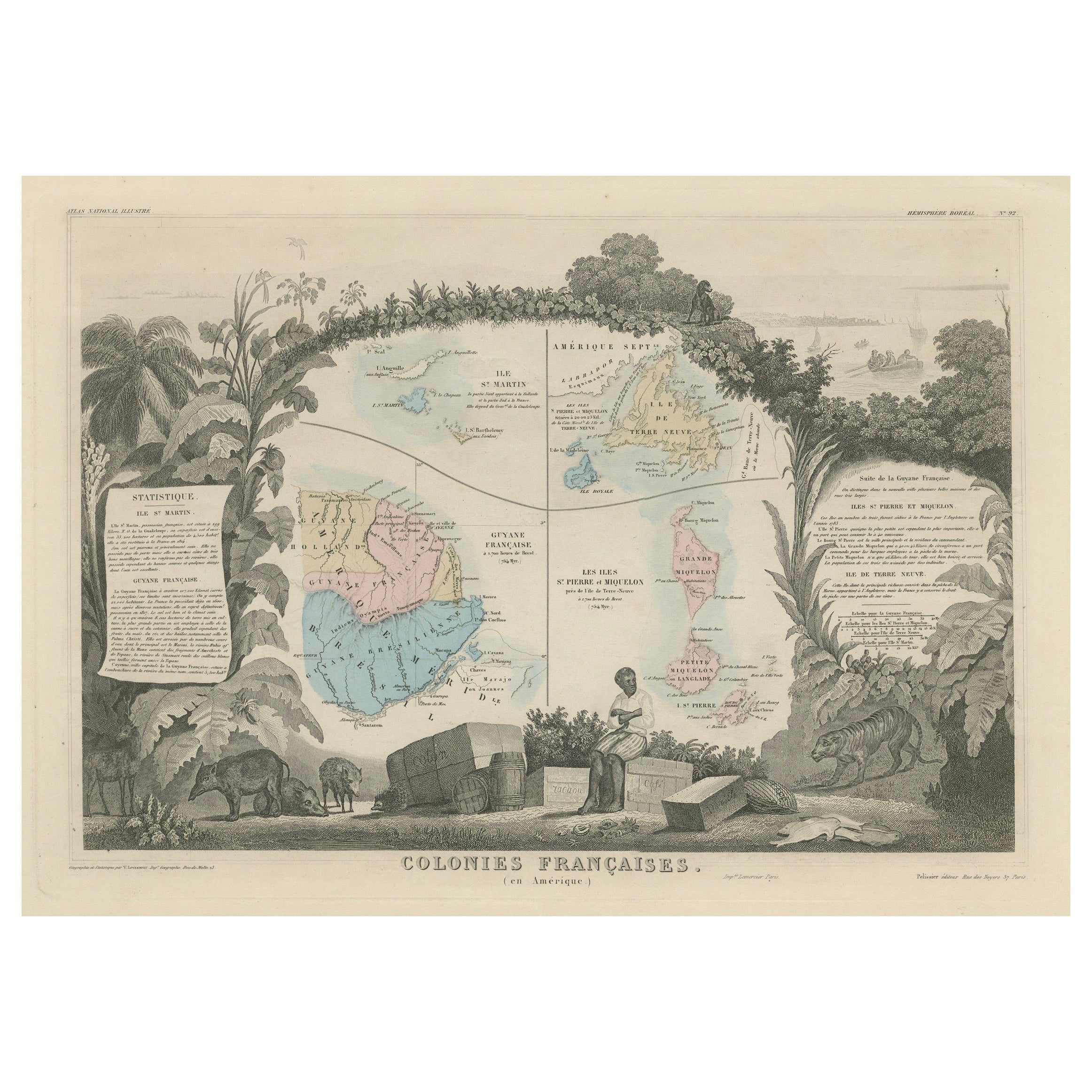
Map of French Colonies in the Americas: St. Martin, French Guiana and St. Pierre
Located in Langweer, NL
This is an intricately detailed map from 1852 titled *Colonies Françaises en Amérique*, depicting several key French colonies in the Americas.
The map focuses on regions such as Fr...
Category
Antique 1850s Maps
Materials
Paper
$176 Sale Price
20% Off
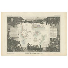
Antique Map of the French Colony Guadeloupe by V. Levasseur, 1854
By Victor Levasseur
Located in Langweer, NL
Antique map titled 'Colonies Françaises (en Amerique). Detailed map of the island of Guadeloupe in the Caribbean Sea, with decorative frame containing views of the island. This map o...
Category
Antique Mid-19th Century Maps
Materials
Paper
$185 Sale Price
20% Off
You May Also Like
Map Colonies Francaises Martinique, 1845
Located in BUNGAY, SUFFOLK
Colonies Francaises, Martinique, Amerique DU SUD
Geographie et Statistique par V.Levasseur. Ing'r Geographe.
Illustre par Raymond Bonheur, peintre.
Grave par Laguihermie, Rue St...
Category
Antique 19th Century French Maps
Materials
Paper

Early 19th Century Hand Colored Map of the United States and Caribbean Islands
Located in Hamilton, Ontario
Hand coloured early 19th century map by Giraldon of France titled "Etats Unis et Grandes Antilles" (United States and Greater Antilles).
Category
Antique Early 19th Century French Maps
Materials
Paper

$595 Sale Price
40% Off
Large1852 Map "Russian Empire" Ric.r0011
Located in Norton, MA
Large
1852 map "Russian Empire"
George Phillips & Son 1852
Ric.r0011
Dimension: Paper: 67 cm W x 52 cm H ; Sight: 60cm W x 50 cm H
Condition: Good Condition with aged tonin...
Category
Antique 19th Century Unknown Maps
Materials
Paper

Map of the Republic of Genoa
Located in New York, NY
Framed antique hand-coloured map of the Republic of Genoa including the duchies of Mantua, Modena, and Parma.
Europe, late 18th century.
Dimension: 25...
Category
Antique Late 18th Century European Maps

19th Century Nautical Chart of Martinique
Located in Norwell, MA
Original map of Martinique from 1887 with chartered waters around the island. Prepared from a French survey, completed in 1825, showing town, ports, rivers and tributaries. Published...
Category
Antique 19th Century Nautical Objects

1752 Vaugoundy Map of Flanders : Belgium, France, and the Netherlands, Ric.a002
Located in Norton, MA
Large Vaugoundy Map of Flanders:
Belgium, France, and the Netherlands
Colored -1752
Ric.a002
Description: This is a 1752 Didier Robert de Vaugondy map of Flanders. The map de...
Category
Antique 17th Century Unknown Maps
Materials
Paper

Recently Viewed
View AllMore Ways To Browse
Rustic Leather Dining Chair
Scandinavian Bentwood Chairs
Scroll Feet Coffee Table
Silver Cake And Knife Set
Silver Sauce Tureen
Single Corner Sofa
Sleeping Sofa
Slice Chair
Sofa Bed Single
Spanish Drinks Table
Star Carved Table
Suzani Bedspread
Teak Carved Panels
Thonet Partable
Triangular Side Table Mid Century
Used Freight Elevators
Vintage 2 Tier Side Table
Vintage 2 Tiered Side Table