Items Similar to French Antique Miniature Map of Germany and Surrounding Countries, 1721


Want more images or videos?
Request additional images or videos from the seller
1 of 6
French Antique Miniature Map of Germany and Surrounding Countries, 1721
About the Item
Antique map Germany titled 'Allemagne Par N. Sanson le Fils Geographe du Roy'. Minitaure map of Germany and surroundings. Originates from 'Introduction a l'Histoire de l'Univers' by S. Pufedorff's. Artists and Engravers: Published by H. Chatelain, Amsterdam.
Artist: Published by H. Chatelain, Amsterdam.
Condition: Good, age-related toning. Please study image carefully.
Date: 1721
Overall size: 0.001 x 18.5 x 16.5 cm.
Image size: 16 x 14 cm.
We sell original antique maps to collectors, historians, educators and interior decorators all over the world. Our collection includes a wide range of authentic antique maps from the 16th to the 20th centuries. Buying and collecting antique maps is a tradition that goes back hundreds of years. Antique maps have proved a richly rewarding investment over the past decade, thanks to a growing appreciation of their unique historical appeal. Today the decorative qualities of antique maps are widely recognized by interior designers who appreciate their beauty and design flexibility. Depending on the individual map, presentation, and context, a rare or antique map can be modern, traditional, abstract, figurative, serious or whimsical. We offer a wide range of authentic antique maps for any budget.
- Dimensions:Height: 6.5 in (16.5 cm)Width: 7.29 in (18.5 cm)Depth: 0 in (0.01 mm)
- Materials and Techniques:
- Period:
- Date of Manufacture:1721
- Condition:
- Seller Location:Langweer, NL
- Reference Number:Seller: BG-093341stDibs: LU3054326351792
About the Seller
5.0
Recognized Seller
These prestigious sellers are industry leaders and represent the highest echelon for item quality and design.
Platinum Seller
Premium sellers with a 4.7+ rating and 24-hour response times
Established in 2009
1stDibs seller since 2017
2,415 sales on 1stDibs
Typical response time: 1 hour
- ShippingRetrieving quote...Shipping from: Langweer, Netherlands
- Return Policy
Authenticity Guarantee
In the unlikely event there’s an issue with an item’s authenticity, contact us within 1 year for a full refund. DetailsMoney-Back Guarantee
If your item is not as described, is damaged in transit, or does not arrive, contact us within 7 days for a full refund. Details24-Hour Cancellation
You have a 24-hour grace period in which to reconsider your purchase, with no questions asked.Vetted Professional Sellers
Our world-class sellers must adhere to strict standards for service and quality, maintaining the integrity of our listings.Price-Match Guarantee
If you find that a seller listed the same item for a lower price elsewhere, we’ll match it.Trusted Global Delivery
Our best-in-class carrier network provides specialized shipping options worldwide, including custom delivery.More From This Seller
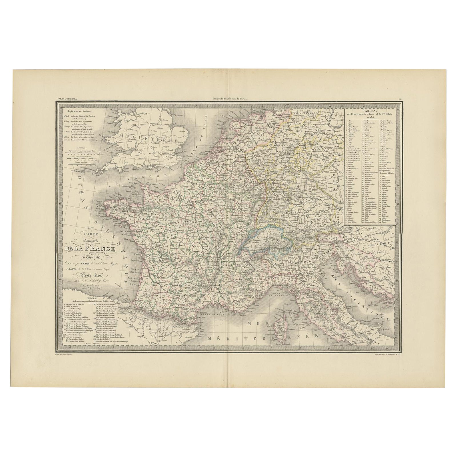
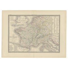
View AllAntique Map of France with Surrounding Countries, 1842
Located in Langweer, NL
Antique map titled 'Carte comparée de la France en 1789 et 1813'. Map of France. This map originates from 'Atlas universel de géographie ancienne et moderne (..)' by Pierre M. Lapie ...
Category
Antique 19th Century Maps
Materials
Paper
Antique Map of Champagne and surrounding Regions, France
Located in Langweer, NL
Antique map titled 'Carte de la Champagne et des Pays Voisins (..)'. Detailed map of Champagne and surrounding regions of Chalons and Soissons, Reims,...
Category
Antique Mid-18th Century Maps
Materials
Paper

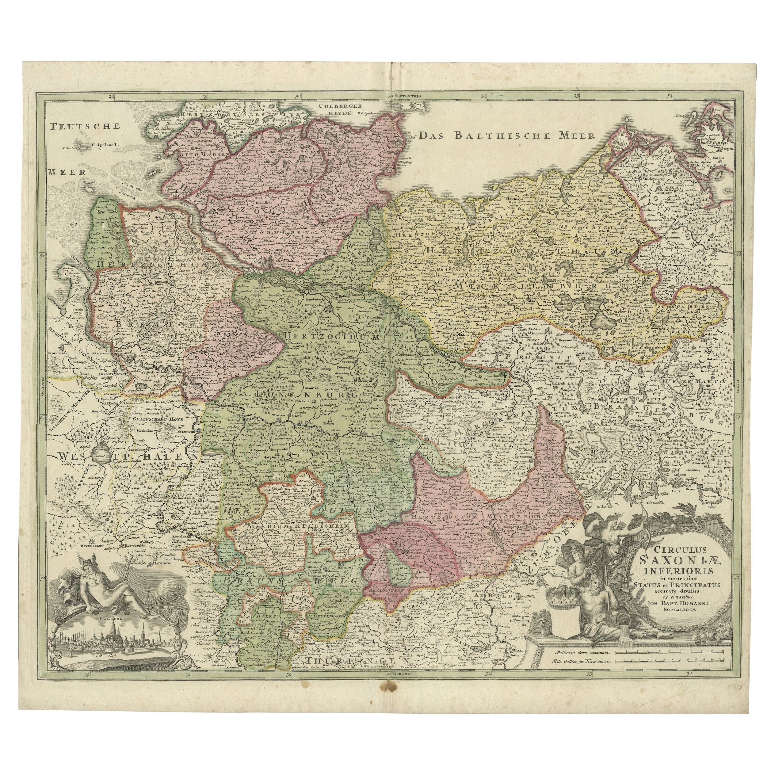
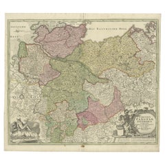
Antique Engraved Map of Saxonia in Northern Germany, ca.1721-1750
Located in Langweer, NL
Duitsland, Sassonia; Johannes Baptist Homann - Circulus Saxoniae Inferioris in omnes suos Status et Principatus accurate divisus ex conatibus -
A large map of Lower Saxony, exten...
Category
Antique Mid-18th Century Maps
Materials
Paper
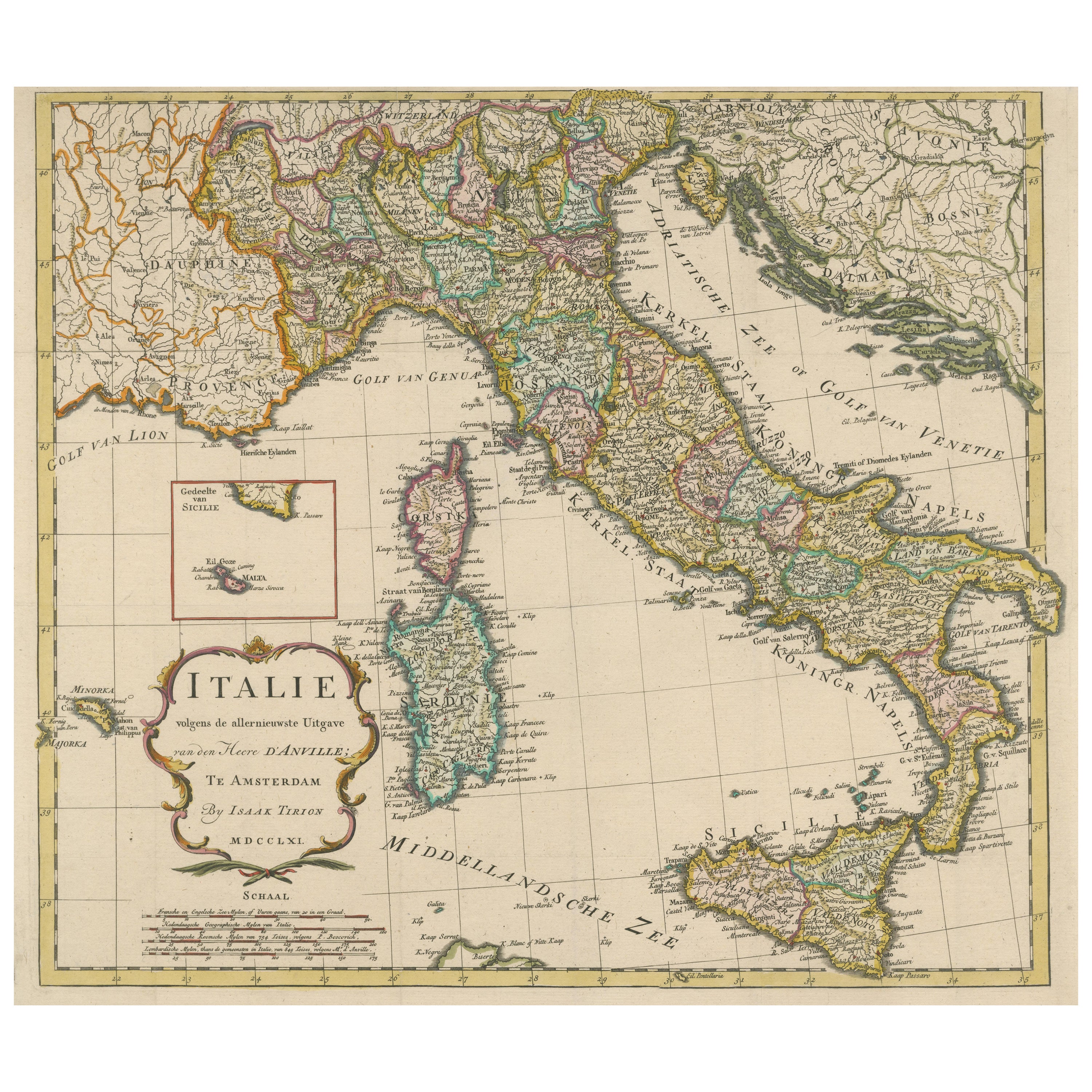
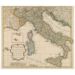
Detailed Antique Map of Italy and surrounding Islands
Located in Langweer, NL
Antique map titled 'Italie volgens de allernieuwste Uitgave van den Heere d'Anville'. Very detailed antique map, based on D'Anville's important map of It...
Category
Antique Mid-18th Century Maps
Materials
Paper
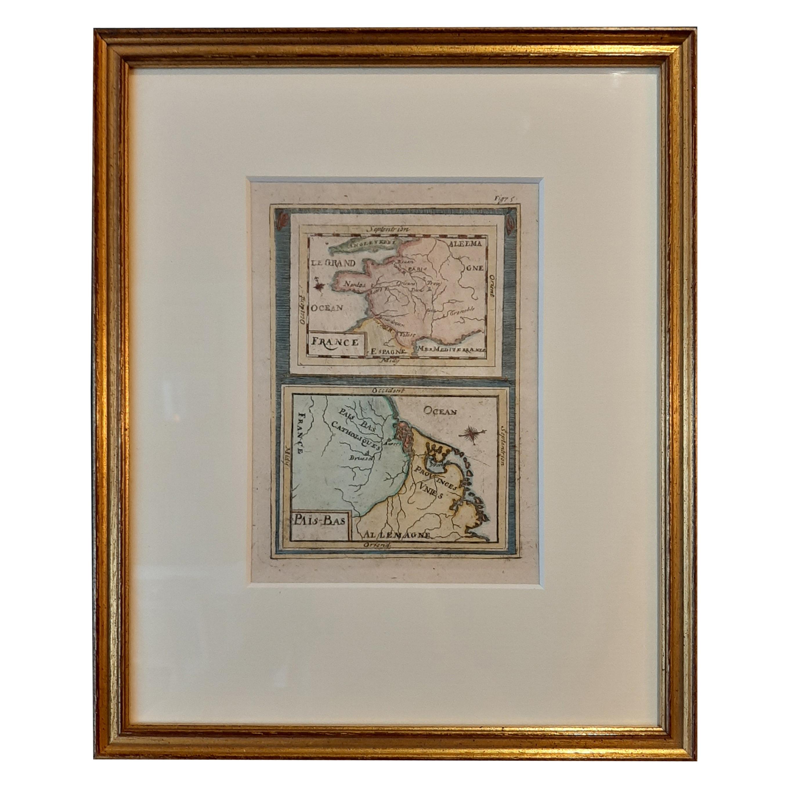
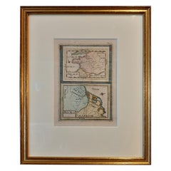
Antique Miniature Map of France and the Low Countries by Mallet, circa 1719
Located in Langweer, NL
Antique map titled 'France - Païs-Bas'. Miniature Map of France and the Low Countries. Published by A.M. Mallet, circa 1719.
Frame included. We carefully pack our framed items to ...
Category
Antique Early 18th Century Maps
Materials
Paper
Miniature Antique Map of England and Wales
Located in Langweer, NL
Miniature map titled 'England & Wales'. Original antique map of England & Wales. This map originates from 'Darton's New Miniature Atlas' publis...
Category
Antique Early 19th Century Maps
Materials
Paper

You May Also Like
East German Map
By VEB Hermann Haack
Located in Baltimore, MD
A brilliantly colourful map of the Leipzig, Karl Marx Stadt and Dresden area in the former German Democratic Republic by VEB Hermann Haack of Gotha.
Category
Vintage 1970s German Maps

$295 Sale Price
25% Off
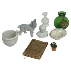
Lot of Eight Miniature Antique German Dollhouse Toys Accessories 1900s
Located in Nuernberg, DE
This rare and exquisite miniature set of 8 antique German Dollhouse Miniatures is a must-have for Dollhouse and Doll collectors and enthusiasts al...
Category
Antique Early 1900s German Folk Art Toys and Dolls
Materials
Pewter
1980s French Antique Handmade Miniature Shoe Made of Silk and Fabric
Located in Marbella, ES
1980s French antique handmade miniature shoe made of silk and fabric
Atelier Jean Claude.
Category
Vintage 1980s Models and Miniatures
Materials
Fabric, Silk
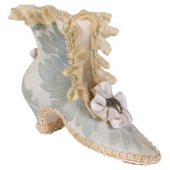
$369 Sale Price
20% Off
1980s French Antique Handmade Miniature Shoe Made of Silk and Fabric
Located in Marbella, ES
1980s French antique handmade miniature shoe made of silk and fabric
Atelier Jean Claude.
Category
Vintage 1980s French Models and Miniatures
Materials
Fabric, Silk
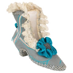
$369 Sale Price
20% Off
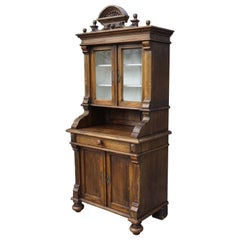
Handmade Antique Miniature Country House Sideboard / Kitchen Cabinet Late 1800s
Located in Lisse, NL
One of a kind, charming and small-size country house cabinet.
This handcrafted, antique cabinet was made for one of two reasons. It was either made as a scale model a sales represen...
Category
Antique Late 19th Century European Country Cabinets
Materials
Brass
Gold Leaf Foil Pictorial Plan Map of the West Country of England Antique Style
Located in West Sussex, Pulborough
We are delighted to offer for sale this lovely Antique style pictorial plan map of the West Country of England etched in gold leaf foil
This is a very interesting and decorative p...
Category
20th Century English Adam Style Maps
Materials
Gold Leaf

$298 Sale Price
20% Off
Recently Viewed
View AllMore Ways To Browse
Modular Sofa Cassina
Organic Cotton Sofa
Ottoman Sale
Outdoor Furniture Metal Bench
Outdoor Metal Bench
Oval Serving Bowl
Pair Of Antique Stools
Pair Three Drawer Tables
Peacock Carpet
Philippe Starck Black Tables
Professional Plaques
Raw Stone Side Table
Reed And Barton Serving Fork
Reed And Barton Serving Spoon
Reed Barton Silver Serving Fork
Regency Bar Italian Made
Rococo Trim
Rodrigues Chair Sergio