Items Similar to Finely Detailed Map Covering Northern Italy, Austria, Slovenia & Croatia, c.1690


Want more images or videos?
Request additional images or videos from the seller
1 of 6
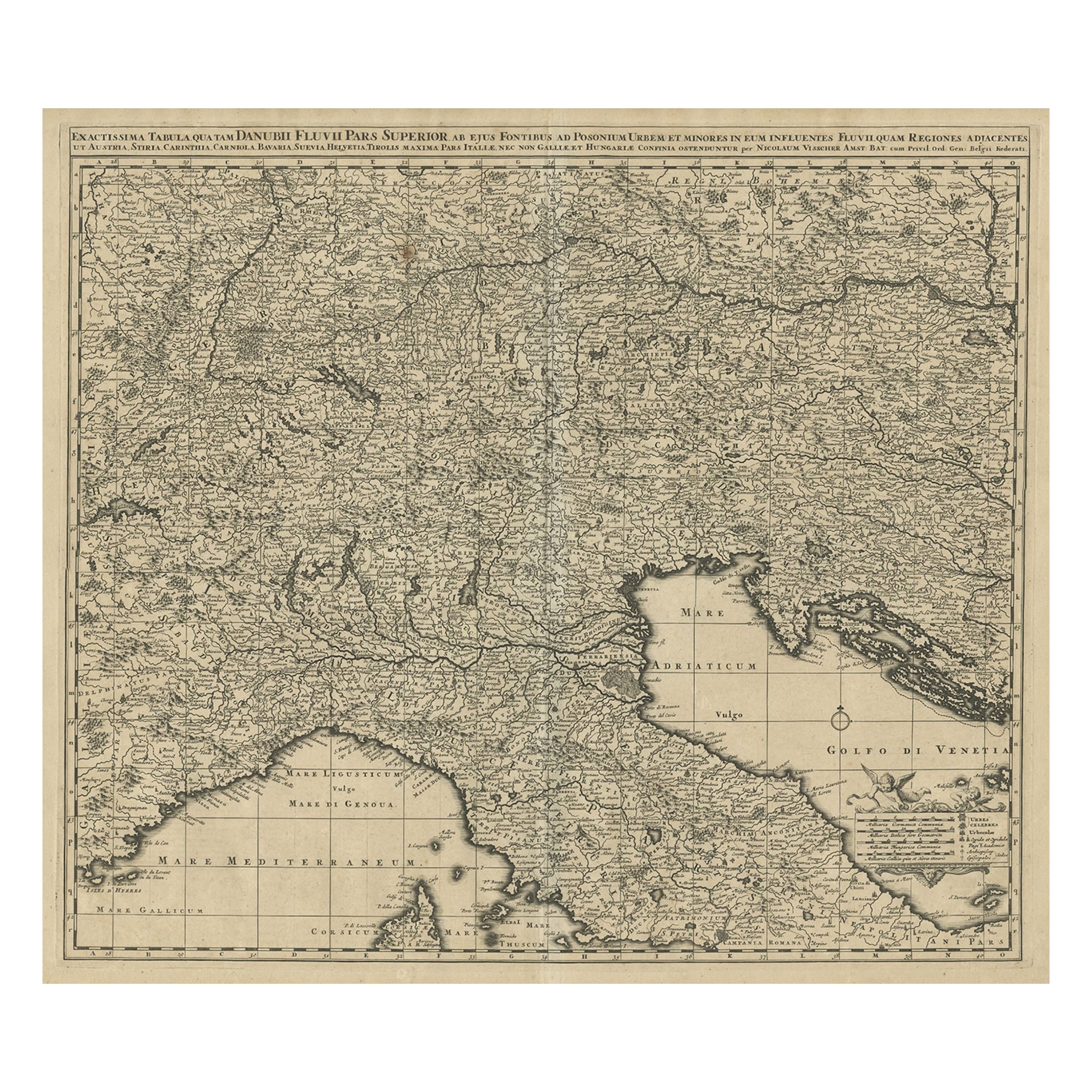
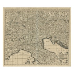
Finely Detailed Map Covering Northern Italy, Austria, Slovenia & Croatia, c.1690
About the Item
Antique map titled 'Exactissima Tabula, qua tam Danubii Fluvii Pars Superior'.
Very finely detailed map covering the region of northern Italy, Austria, Slovenia and Croatia. The course of the Danube is prominently shown from its headwaters in the Alps to its confluence with the Morava River. Source unknown, to be determined.
Artists and Engravers: Made by 'Nicolaes Visscher' after an anonymous artist. Nicolaes Visscher II (1649, Amsterdam – 1702, Amsterdam) was a Dutch engraver, cartographer and publisher. He was the son of Nicolaes Visscher I and the grandson of Claes Janszoon Visscher. After his death, his wife, Elisabeth, continued the family tradition of mapmaking and publishing. The works, engraved plates, were then sold to Peter Schenk, who also reprinted them.
Condition: Very good, given age. Original/contemporary hand coloring, blank verso. Some soft creases. Minor paper separation bottom middle fold; repaired. A few small unobtrusive spots. Original middle fold as issued. General age-related toning and/or occasional minor defects from handling. Please study image carefully.
- Dimensions:Height: 20.63 in (52.4 cm)Width: 23.31 in (59.2 cm)Depth: 0 in (0.02 mm)
- Materials and Techniques:
- Period:1690-1699
- Date of Manufacture:circa 1690
- Condition:Repaired: Minor paper separation bottom middle fold; repaired. A few small unobtrusive spots. Wear consistent with age and use. Condition: Very good, given age. Original/contemporary hand coloring, blank verso. Some soft creases. Minor paper separation bottom middle fold; repaired. A few small unobtrusive spots. Original middle fold as issued. General age-related toning.
- Seller Location:Langweer, NL
- Reference Number:Seller: PC-589361stDibs: LU3054326789382
About the Seller
5.0
Recognized Seller
These prestigious sellers are industry leaders and represent the highest echelon for item quality and design.
Platinum Seller
Premium sellers with a 4.7+ rating and 24-hour response times
Established in 2009
1stDibs seller since 2017
2,415 sales on 1stDibs
Typical response time: 1 hour
- ShippingRetrieving quote...Shipping from: Langweer, Netherlands
- Return Policy
Authenticity Guarantee
In the unlikely event there’s an issue with an item’s authenticity, contact us within 1 year for a full refund. DetailsMoney-Back Guarantee
If your item is not as described, is damaged in transit, or does not arrive, contact us within 7 days for a full refund. Details24-Hour Cancellation
You have a 24-hour grace period in which to reconsider your purchase, with no questions asked.Vetted Professional Sellers
Our world-class sellers must adhere to strict standards for service and quality, maintaining the integrity of our listings.Price-Match Guarantee
If you find that a seller listed the same item for a lower price elsewhere, we’ll match it.Trusted Global Delivery
Our best-in-class carrier network provides specialized shipping options worldwide, including custom delivery.More From This Seller
View AllAntique Map Covering Northern Italy, Austria, Slovenia & Croatia, ca.1690
Located in Langweer, NL
Antique map titled 'Exactissima Tabula, qua tam Danubii Fluvii Pars Superior'.
Detailed map covering the region of northern Italy, Austria, Slovenia and Croatia. The course of th...
Category
Antique 1690s Maps
Materials
Paper
$791 Sale Price
20% Off
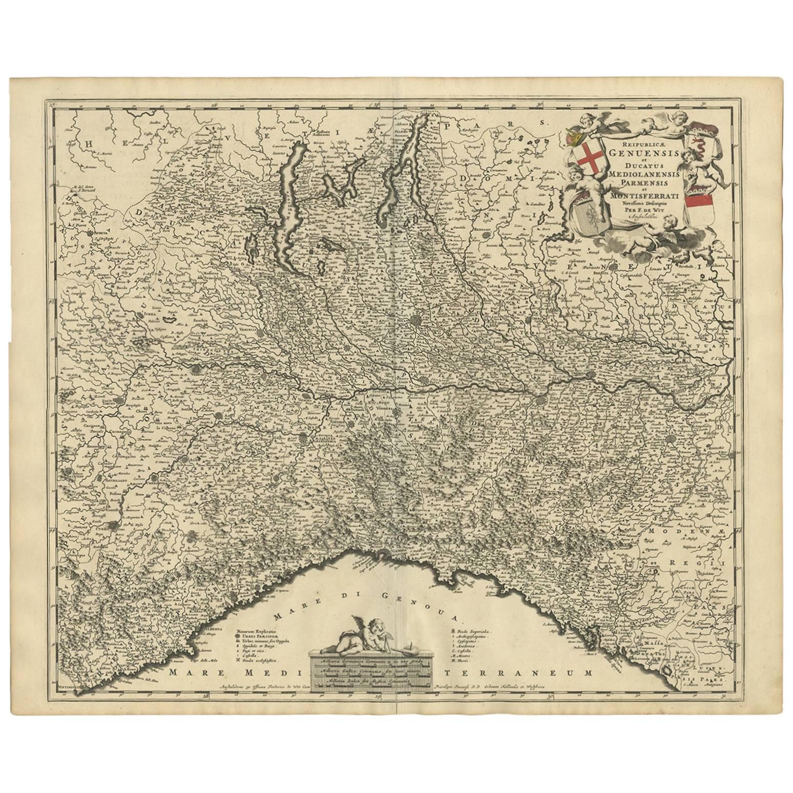
Antique Map of Northern Italy by F. de Wit, 1690
Located in Langweer, NL
A very decorative map centered on Genua, and including the towns of Milan, Torino, Parma, Cremona, etc. Decorative title cartouche upper right, five putti holding the arms of the reg...
Category
Antique Late 17th Century Maps
Materials
Paper
$511 Sale Price
20% Off
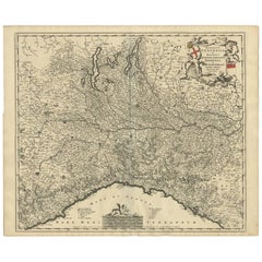
Antique Map of Austria by N. Visscher, circa 1690
Located in Langweer, NL
Antique map titled 'Austriae Archiducatus pars superior in omnes ejusdem'. Spectacular large map of Upper and Lower Austria between Passau and Wien with figurative cartouche and armo...
Category
Antique Late 17th Century Maps
Materials
Paper

$814 Sale Price
24% Off
Antique Map of Austria by F. de Wit, 1690
Located in Langweer, NL
Antique map titled 'Circuli Austriaci pars Septentrionalis in qua Archiducatus'. Decorative and detailed map of Austria by F. de Wit.
Category
Antique Late 17th Century Maps
Materials
Paper

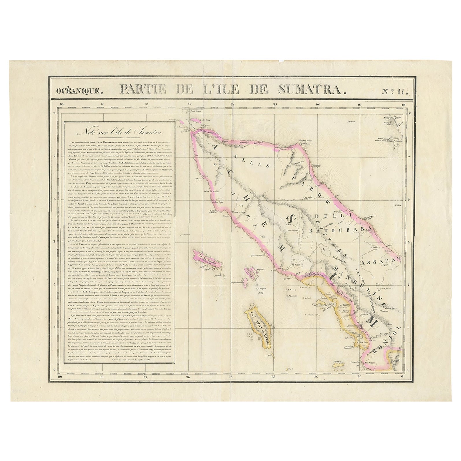
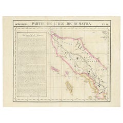
Detailed Antique Map of Northern Sumatra, Indonesia, circa 1825
Located in Langweer, NL
Antique map titled 'Partie de l'Ile de Sumatra'. Chart showing the northern part of Sumatra. Originates from 'Atlas Universel' by P.M. Vandermaelen.
Artists and Engravers: Philip...
Category
Antique 19th Century Maps
Materials
Paper
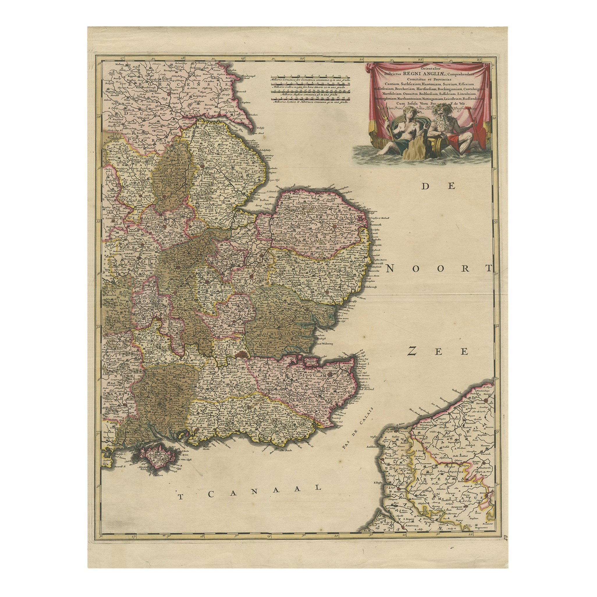
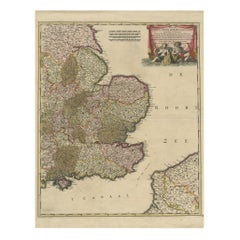
Detailed Antique Map of Southeast England, incl Warwickshire and Hampshire, 1690
Located in Langweer, NL
Antique map titled 'Orientalior districtus Regni Angliae (..)'.
Detailed map of southeast England encompassing the country from Lincolnshire and the Wash south and including Warw...
Category
Antique 1690s Maps
Materials
Paper
You May Also Like
Hand-Colored 18th Century Homann Map of the Danube, Italy, Greece, Croatia
By Johann Baptist Homann
Located in Alamo, CA
"Fluviorum in Europa principis Danubii" is a hand colored map of the region about the Danube river created by Johann Baptist Homann (1663-1724) in his 'Atlas Novus Terrarum', publish...
Category
Antique Early 18th Century German Maps
Materials
Paper

Northern Scotland: A 16th Century Hand-colored Map by Mercator
By Gerard Mercator
Located in Alamo, CA
A framed hand-colored 16th century map of Northern Scotland by Gerard Mercator entitled "Scotiae pars Septentrionalis", published in Amsterdam in 1636. It is a highly detailed map of the northern part of Scotland, with the northwest Highlands and the cities Inverness and Aberdeen, as well as the Orkney Islands and the Hebrides. There is a decorative title cartouche in the upper left corner.
The map is presented in an antiqued brown wood...
Category
Antique 16th Century Dutch Maps
Materials
Paper

Northern Scotland: A 17th Century Hand-colored Map by Mercator
By Gerard Mercator
Located in Alamo, CA
This is a framed hand-colored 17th century map of Northern Scotland by Gerard Mercator entitled "Scotiae pars Septentrionalis", published in Amsterdam in 1636. It is a highly detailed map of the northern part of Scotland, with the northwest Highlands and the cities Inverness and Aberdeen, as well as the Orkney Islands and the Hebrides. There is a decorative title cartouche in the upper left corner.
The map is presented in an antiqued brown wood...
Category
Antique 1630s Dutch Maps
Materials
Paper

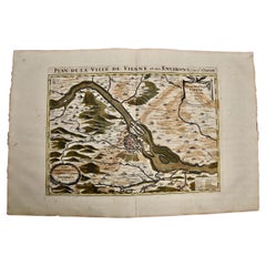
Vienna, Austria: A Large 17th Century Hand-Colored Map by Sanson and Jaillot
By Nicolas Sanson
Located in Alamo, CA
This large 17th century hand-colored map of Vienna, Austria and the surrounding countryside and villages entitled "Plan de la Ville de Vienne en Austrich...
Category
Antique 1690s French Maps
Materials
Paper
Hand Colored 18th Century Homann Map of Austria Including Vienna and the Danube
By Johann Baptist Homann
Located in Alamo, CA
"Archiducatus Austriae inferioris" is a hand colored map of Austria created by Johann Baptist Homann (1663-1724) and published in Nuremberg, Germany in 1728 shortly after his death. ...
Category
Antique Early 18th Century German Maps
Materials
Paper

Antique Map of Italy by Andriveau-Goujon, 1843
By Andriveau-Goujon
Located in New York, NY
Antique Map of Italy by Andriveau-Goujon, 1843. Map of Italy in two parts by Andriveau-Goujon for the Library of Prince Carini at Palazzo Carini i...
Category
Antique 1840s French Maps
Materials
Linen, Paper

$3,350 / set
Recently Viewed
View AllMore Ways To Browse
Croatian Artist
Metal High Top Stools
Metal Trolley On Wheels
Mid Century Chiavari Chairs
Mid Century Small Bar Cart
Mid Century Teak Serving Tray
Narrow White Tables
Oak Dining Table With Inlay
Oak Hall Bench
Oakwood Chair
Orange Tibetan Rugs
Orange Velvet Sofa
Painted Antique Pitcher
Painted Console Table With Drawers
Pair Palazzo Italy
Pedestal Dish
Pedestal Table With Lion Feet
Pomegranate Tree