Items Similar to Engraving of a Map of Florida, the Gulf Coast, Caribbean & Central America, 1728


Want more images or videos?
Request additional images or videos from the seller
1 of 7
Engraving of a Map of Florida, the Gulf Coast, Caribbean & Central America, 1728
About the Item
This exceptional antique map, titled "Nouvelle Carte Marine de Toute les Cotes de l´Amerique" and alternatively known as "Nieuwe groote en seer Curieuse Paskaart van Geheel-WestIndien," is a splendid piece of cartographic history. Created by the renowned mapmaker Jan Sikkena and published by Gerard Van Keulen, the son of the famous Johannes Van Keulen, around 1728, this map is a testament to the art and science of early 18th-century mapmaking.
The map showcases a meticulous and comprehensive depiction of Florida, the Gulf Coast, the Caribbean, and Central America. What sets it apart is its beautiful original, or contemporary, hand coloring, which adds a vivid and authentic touch to this historical artifact. The colors used are rich and vibrant, highlighting the detailed cartography and enhancing the overall aesthetic appeal of the map.
As a collector's item, this map stands out for its remarkable precision and attention to detail. The craftsmanship is evident in every aspect of the map, from the intricate coastlines and detailed geographical features to the delicate labeling of regions and landmarks. The map not only serves as a navigational tool but also as a work of art, reflecting the skill and dedication of its creator, Jan Sikkena.
The publication of this map by Gerard Van Keulen, continuing the legacy of his father Johannes, adds to its historical significance. The Van Keulen family was renowned for their contribution to maritime cartography, and this map is a fine example of their expertise and influence in the field.
Overall, this map is not just a navigational aid but a piece of history, encapsulating the knowledge, artistry, and skill of early 18th-century mapmaking. Its exceptional detail, beautiful hand coloring, and historical significance make it a prized possession for any collector or enthusiast of antique maps.
- Dimensions:Height: 24.61 in (62.5 cm)Width: 40.56 in (103 cm)Depth: 0.02 in (0.5 mm)
- Materials and Techniques:
- Place of Origin:
- Period:
- Date of Manufacture:circa 1728
- Condition:Original folding lines and original/contemporary hand coloring. General age-related toning, minor wear. Blank verso. Please study image carefully.
- Seller Location:Langweer, NL
- Reference Number:Seller: BGVZ-0011stDibs: LU3054320826202
About the Seller
5.0
Recognized Seller
These prestigious sellers are industry leaders and represent the highest echelon for item quality and design.
Platinum Seller
Premium sellers with a 4.7+ rating and 24-hour response times
Established in 2009
1stDibs seller since 2017
2,418 sales on 1stDibs
Typical response time: <1 hour
- ShippingRetrieving quote...Shipping from: Langweer, Netherlands
- Return Policy
Authenticity Guarantee
In the unlikely event there’s an issue with an item’s authenticity, contact us within 1 year for a full refund. DetailsMoney-Back Guarantee
If your item is not as described, is damaged in transit, or does not arrive, contact us within 7 days for a full refund. Details24-Hour Cancellation
You have a 24-hour grace period in which to reconsider your purchase, with no questions asked.Vetted Professional Sellers
Our world-class sellers must adhere to strict standards for service and quality, maintaining the integrity of our listings.Price-Match Guarantee
If you find that a seller listed the same item for a lower price elsewhere, we’ll match it.Trusted Global Delivery
Our best-in-class carrier network provides specialized shipping options worldwide, including custom delivery.More From This Seller
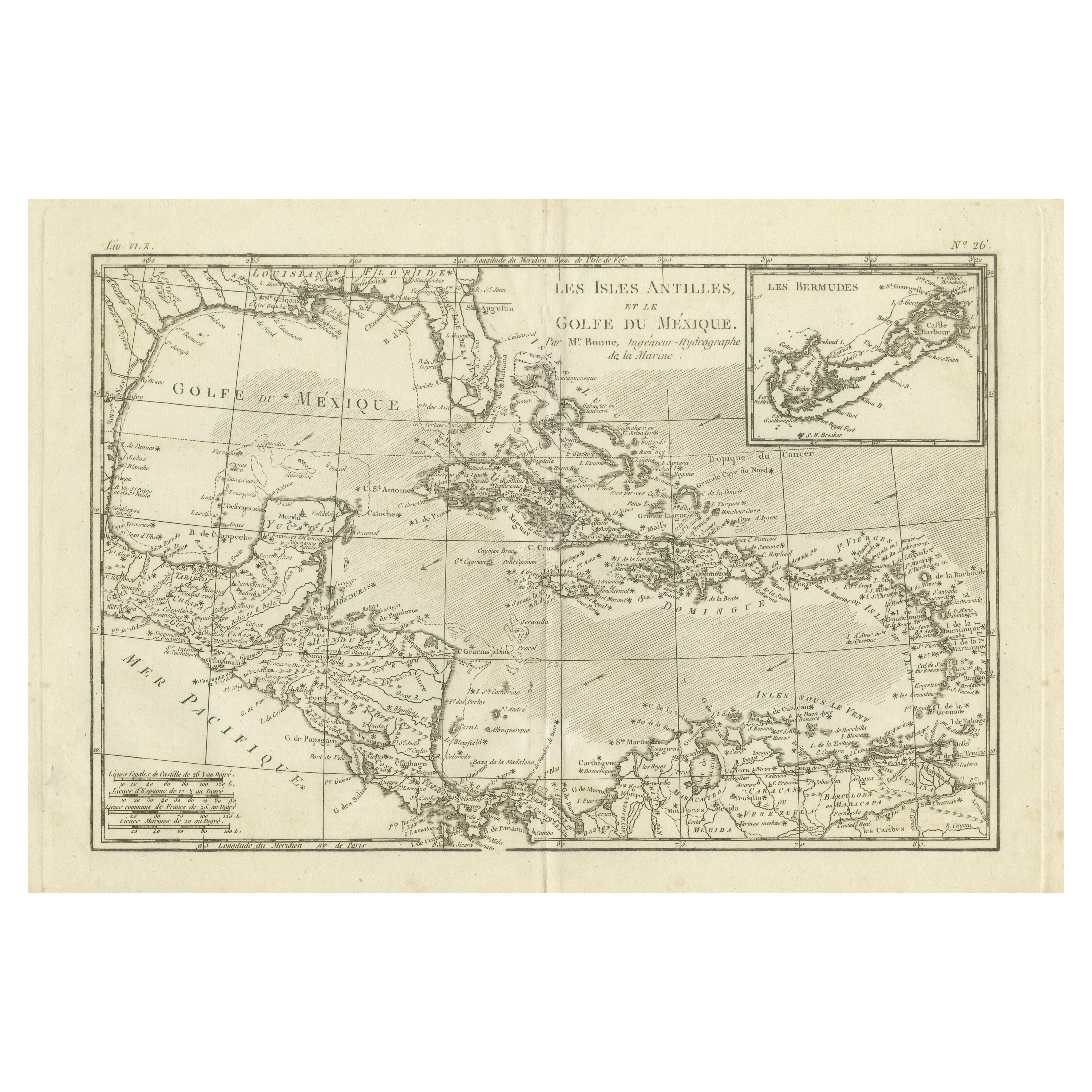
View AllAuthentic Antique Map of the Caribbean, Gulf Coast and Central America, 1787
Located in Langweer, NL
Antique map titled 'Les Isles Antilles et le Golfe du Méxique'. Original old map of the Caribbean, Gulf Coast and Central America. With inset map of Bermuda...
Category
Antique Late 18th Century Maps
Materials
Paper
Antique Map of the United States of America, also showing the Caribbean
Located in Langweer, NL
Antique map titled 'Verein-Staaten von Nord-America, Mexico, Yucatan u.a.'. Very detailed map of the United States of America showing the ...
Category
Antique Mid-19th Century Maps
Materials
Paper

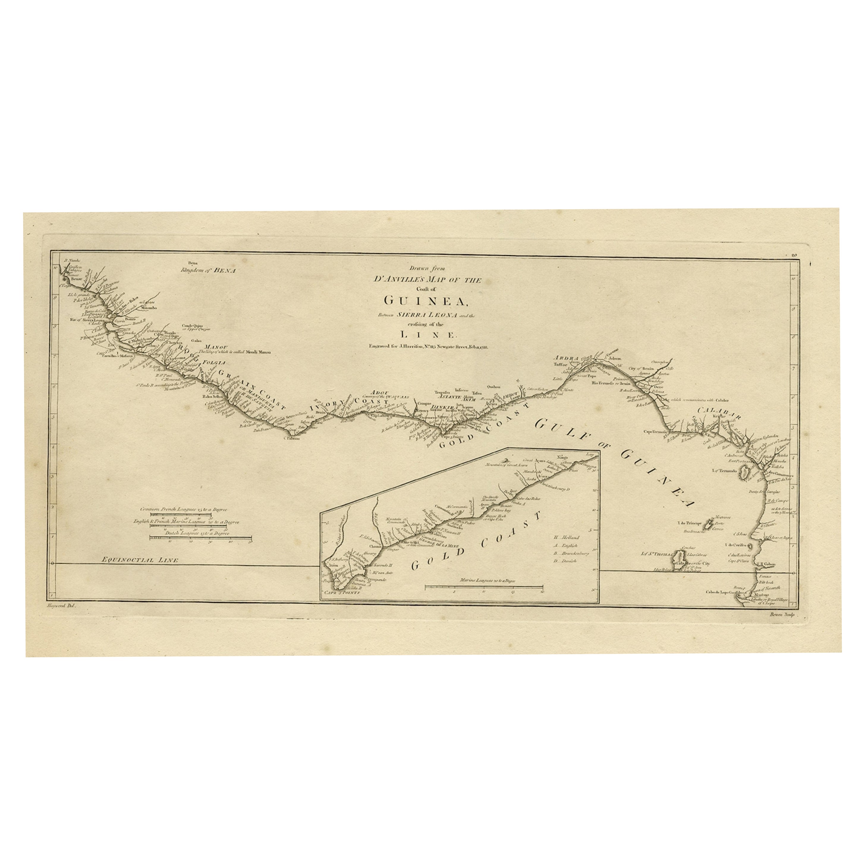
Map of the African Coast, Gulf of Guinea, from Sierra Leone to Gabon, 1788
Located in Langweer, NL
Antique map titled 'Drawn from d'Anvilles Map of the Coast of Guinea, Between Sierra Leone and the crossing of the Line.'
Map of the African coast, Gulf of Guinea, from Sierra Le...
Category
Antique 1780s Maps
Materials
Paper
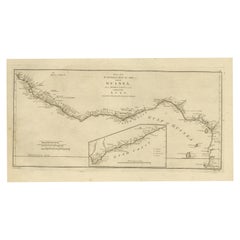
$427 Sale Price
20% Off
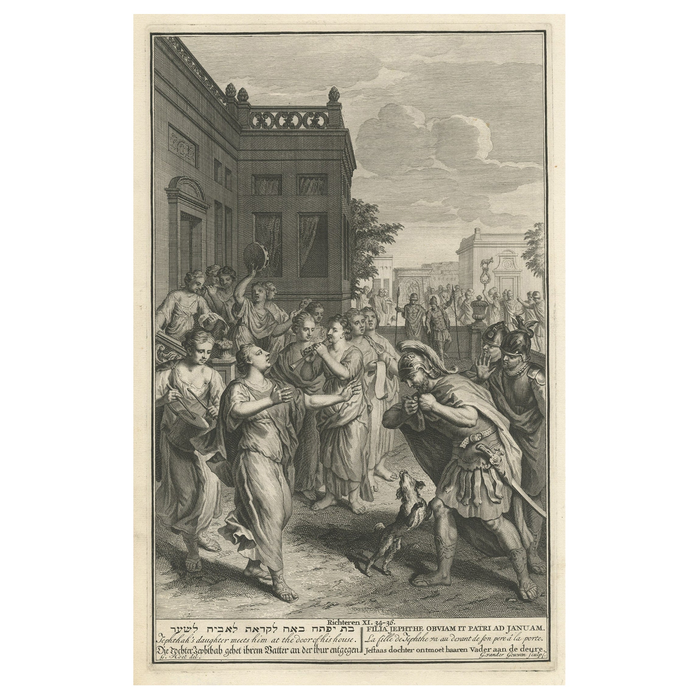
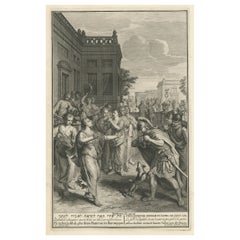
Antique Engraving of the Story of Jephthah’s Daughter, 1728
Located in Langweer, NL
Antique religion print titled 'Jephthah's daughter meets him at the door of his house'.
The story of Jephthah’s Daughter (Judges 11) tells us that Jephthah the Gileadite made a vow to the Lord before going into battle with the Ammonites. This print originates from 'Figures de la Bible'.
Artists and Engravers: Published by P. de Hondt. Illustrated by Gerard Hoet...
Category
Antique 1720s Prints
Materials
Paper
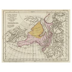
Antique Map of the West Coast of North America & North East Coast of Asia '1772'
Located in Langweer, NL
Antique map titled 'Carte des nouvelles decouvertes/ Extrait d'une Carte Japonoise de l'Universe'. Map of the West Coast of North America and North-East Coast of Asia, based upon Buache's report of the various Russian Discoveries between 1731 and 1742 including the various explorers routes and notes. The lower map is based upon a Japanese map...
Category
Antique Late 18th Century Maps
Materials
Paper

$604 Sale Price
20% Off
Interesting Old Map of the Nw Coast of America and the Ne Coast of Asia, ca.1772
Located in Langweer, NL
Antique map titled 'Carte Generale des Decouvertes de l'Amiral de Fonte (..)'.
Original antique map of the discoveries of Admiral de Fonte, showing the possibility of a north-west passage. Interesting map of the NW Coast...
Category
Antique 1770s Maps
Materials
Paper
$551 Sale Price
35% Off
You May Also Like
Original Antique Map of Central America / Florida, Arrowsmith, 1820
Located in St Annes, Lancashire
Great map of Central America.
Drawn under the direction of Arrowsmith.
Copper-plate engraving.
Published by Longman, Hurst, Rees, Orme and Brown, 1820
Unframed.
Category
Antique 1820s English Maps
Materials
Paper

New Map of North America from the Latest Discoveries, 1763
Located in Philadelphia, PA
A fine antique 18th century map of the North American seaboard.
Entitled "A New Map of North America from the Latest Discoveries 1763".
By the Cartographer/Engraver - John Spil...
Category
Antique Mid-18th Century English Georgian Maps
Materials
Paper

Map of the Republic of Genoa
Located in New York, NY
Framed antique hand-coloured map of the Republic of Genoa including the duchies of Mantua, Modena, and Parma.
Europe, late 18th century.
Dimension: 25...
Category
Antique Late 18th Century European Maps

Original Antique Map of South America. C.1780
Located in St Annes, Lancashire
Great map of South America
Copper-plate engraving
Published C.1780
Two small worm holes to left side of map
Unframed.
Category
Antique Early 1800s English Georgian Maps
Materials
Paper

Map "Estuary- Mouth of the Thames"
Located in Alessandria, Piemonte
ST/426 - Antique French Map of the estuary of the Thames, map dated 1769 -
"Mape of the entrance of the Thames. Designed by filing of Navy cards fo...
Category
Antique Mid-18th Century French Other Prints
Materials
Paper

Original Antique Map of the American State of Florida, 1903
Located in St Annes, Lancashire
Antique map of Florida
Published By A & C Black. 1903
Original colour
Good condition
Unframed.
Free shipping
Category
Antique Early 1900s English Maps
Materials
Paper
Recently Viewed
View AllMore Ways To Browse
18th Century Art Tools
Antique Florida Map
Malabar Map
Malaysia Map
Framed Africa Maps
Jamaican Antique
Antique Map Chile
Antique Map Of Boston
Antique Map Of Turkish Empire
Ipswich Antique Furniture
Prussia Map
Antique Maps Of Texas
Antique Mississippi Map
Canadian Atlas Furniture
Ottoman Map
Antique Compass Made In France
Constantinople Istanbul
Hindeloopen Furniture