Items Similar to Decorative Antique Map of Eastern Canada, Published in 1882


Want more images or videos?
Request additional images or videos from the seller
1 of 7
Decorative Antique Map of Eastern Canada, Published in 1882
About the Item
This is a historical map from the 1882 Blackie Atlas, focused on eastern Canada and the maritime provinces. The map is titled "Canada. No. 2. Provinces of Nova Scotia, New Brunswick, Prince Edward Island, Newfoundland." The Gulf of St. Lawrence is a prominent feature, with the surrounding lands and waterways detailed intricately.
On the map, the provinces of Nova Scotia and New Brunswick are color differentiated, with Prince Edward Island and the Newfoundland island clearly marked. The topography is indicated by hachure marks, which are used to denote the relief and mountains, a common practice before the development of contour lines.
Major cities, towns, rivers, and other geographical features are noted, allowing for a detailed understanding of the region's geography at the time. The railway lines are also likely indicated, as they were an important part of the area's infrastructure and development.
In the bottom right corner, there appears to be an inset map providing a more detailed view of Newfoundland, which shows its rugged coastline and internal features. The presence of such detailed mapping of the area reflects its significance for shipping, fishing, and transatlantic travel and communication during the late 19th century.
The map's longitude and latitude markers, the detailed scale at the bottom, and the clear labeling of the geographical features all indicate that this map was a practical tool for education and navigation at the time of its creation.
- Dimensions:Height: 14.97 in (38 cm)Width: 22.45 in (57 cm)Depth: 0 in (0.02 mm)
- Materials and Techniques:
- Period:
- Date of Manufacture:1882
- Condition:Good condition, folding line in the middle. The outer borders are slightly discolored due to age, but not the image. Study the image carefully.
- Seller Location:Langweer, NL
- Reference Number:Seller: BG-13601-2-591stDibs: LU3054338776152
About the Seller
5.0
Recognized Seller
These prestigious sellers are industry leaders and represent the highest echelon for item quality and design.
Platinum Seller
Premium sellers with a 4.7+ rating and 24-hour response times
Established in 2009
1stDibs seller since 2017
2,412 sales on 1stDibs
Typical response time: 1 hour
- ShippingRetrieving quote...Shipping from: Langweer, Netherlands
- Return Policy
Authenticity Guarantee
In the unlikely event there’s an issue with an item’s authenticity, contact us within 1 year for a full refund. DetailsMoney-Back Guarantee
If your item is not as described, is damaged in transit, or does not arrive, contact us within 7 days for a full refund. Details24-Hour Cancellation
You have a 24-hour grace period in which to reconsider your purchase, with no questions asked.Vetted Professional Sellers
Our world-class sellers must adhere to strict standards for service and quality, maintaining the integrity of our listings.Price-Match Guarantee
If you find that a seller listed the same item for a lower price elsewhere, we’ll match it.Trusted Global Delivery
Our best-in-class carrier network provides specialized shipping options worldwide, including custom delivery.More From This Seller
View AllAntique Map of Eastern Canada with an inset Map of Newfoundland, 1882
Located in Langweer, NL
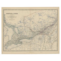
Antique map titled 'Dominion of Canada'. Old map of Eastern Canada with an inset map of Newfoundland. This map originates from 'The Royal Atlas of Modern Geography, Exhibiting, in a ...
Category
Antique 19th Century Maps
Materials
Paper

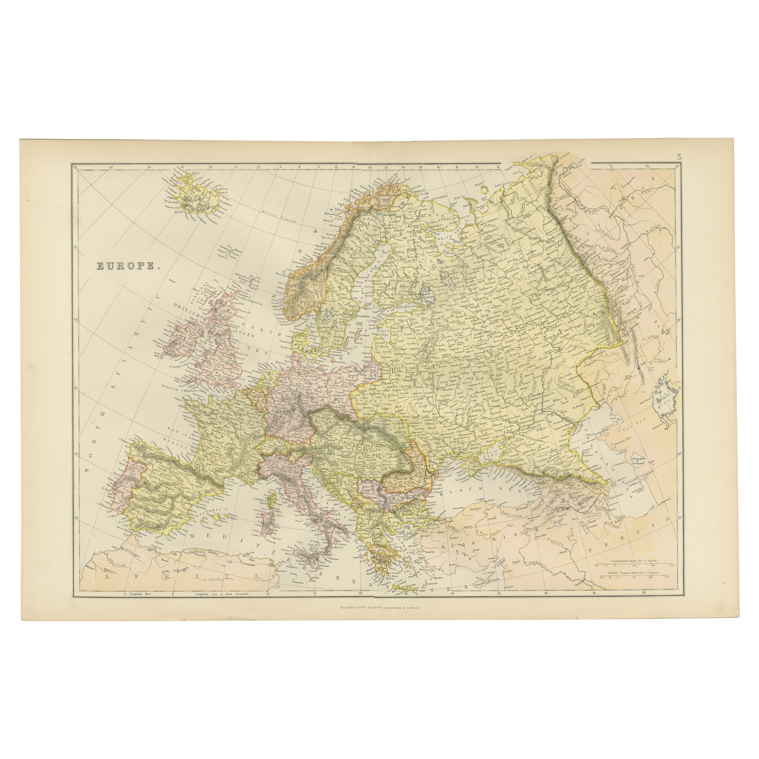
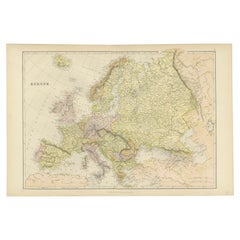
Colorful Detailed Antique Map of Europe, Published in 1882
Located in Langweer, NL
"The Antique Map of Europe from 'The Comprehensive Atlas and Geography of the World,' published in 1882 by Blackie & Son, is a testament to meticulous cartography and scholarly preci...
Category
Antique 1880s Maps
Materials
Paper
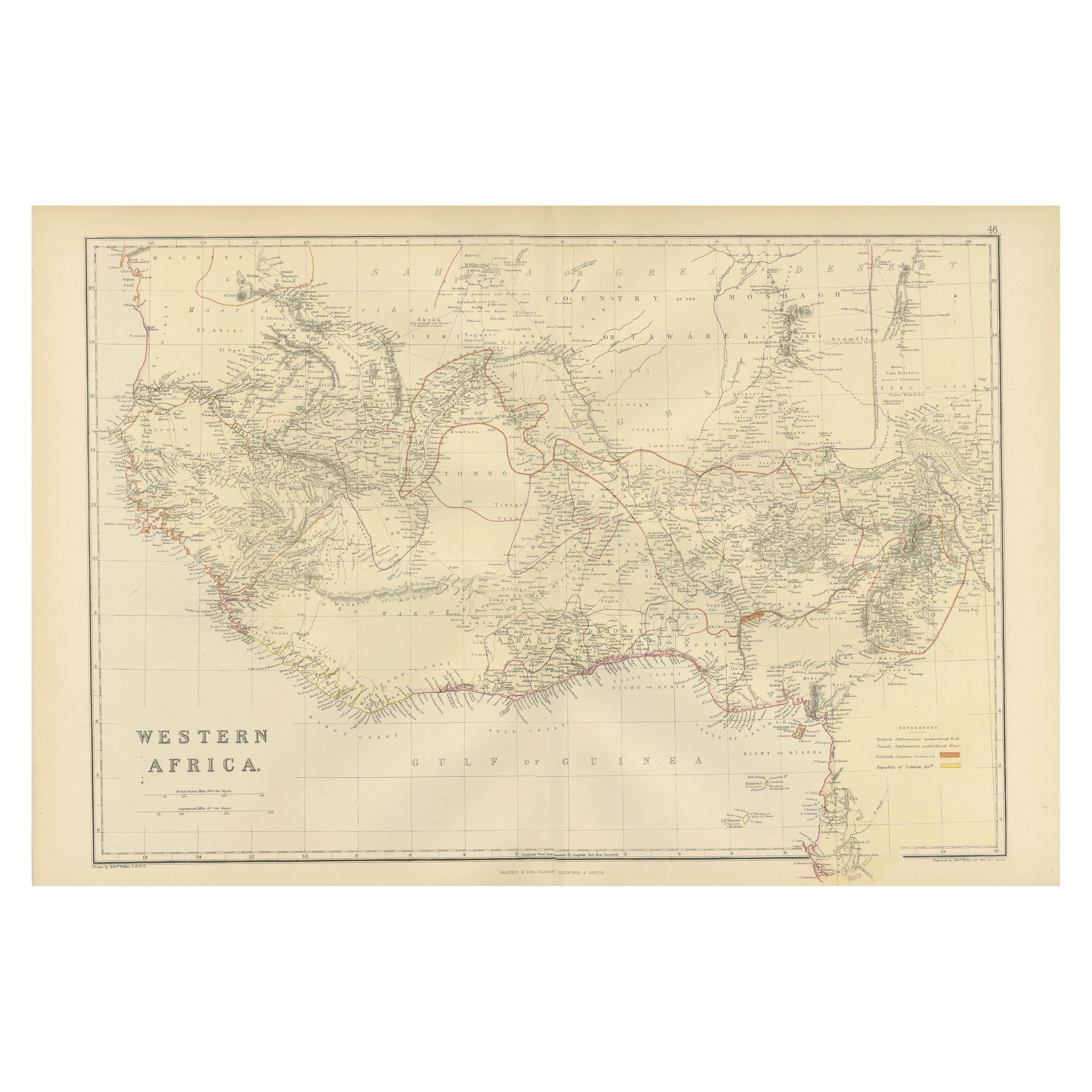
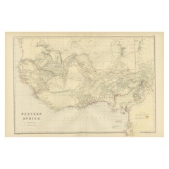
Original Antique Coloured Map of Western Africa, Published in 1882
Located in Langweer, NL
This is a map of Western Africa from the 1882 Blackie & Son atlas. The map details the West African coast from the Sahara Desert in the north down to the Gulf of Guinea, including a ...
Category
Antique 1880s Maps
Materials
Paper
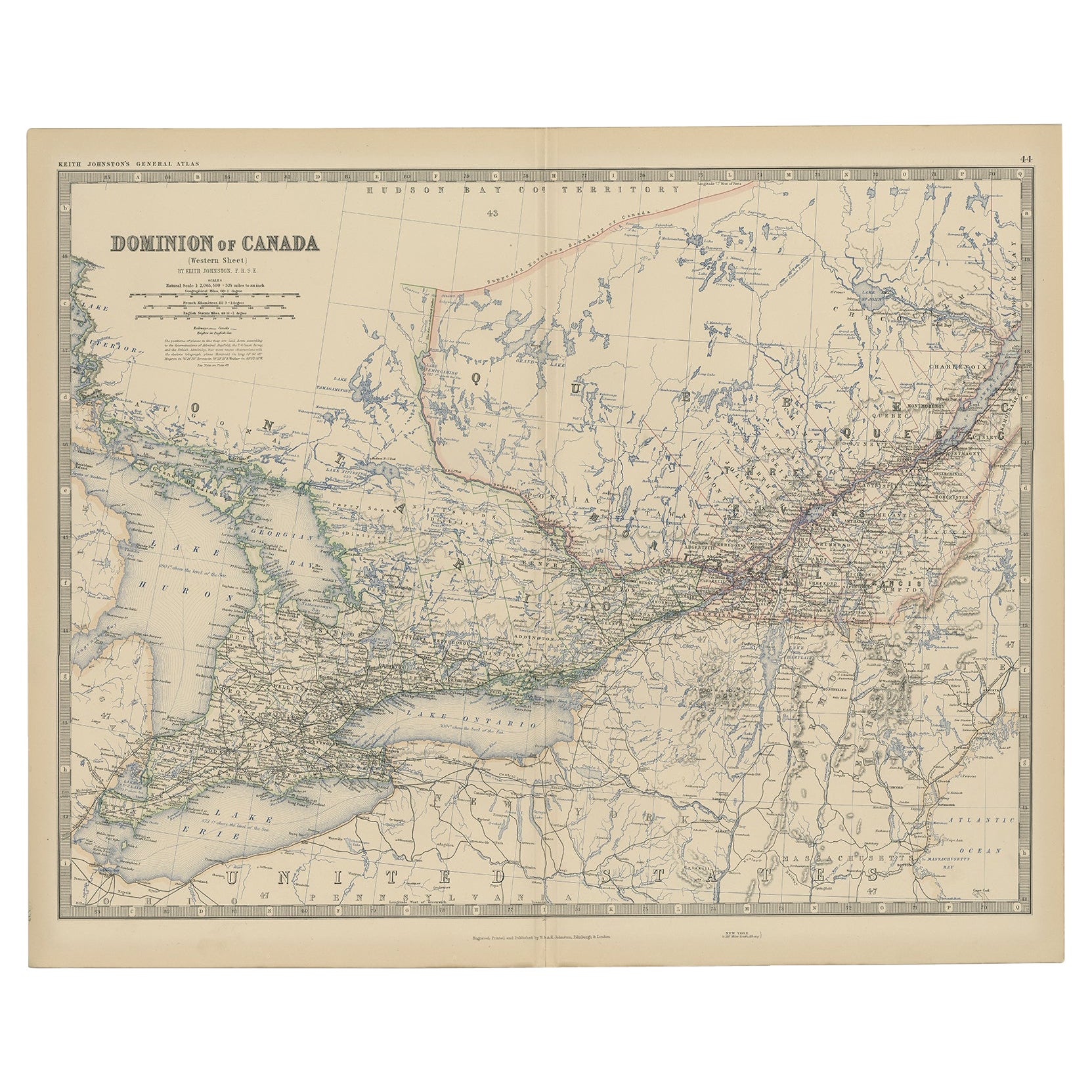
Old Original Antique Map of Western Canada, 1882
Located in Langweer, NL
Antique map titled 'Dominion of Canada'.
Old map of Western Canada. This map originates from 'The Royal Atlas of Modern Geography, Exhibiting, in a ...
Category
Antique 1880s Maps
Materials
Paper
$259 Sale Price
20% Off
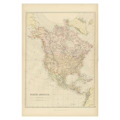
Antique Decorative Coloured Map of North America, 1882
Located in Langweer, NL
This original antique map of North America is from the Blackie & Son Atlas published in 1882. Here are several points of interest about this map:
1. **Political Borders**: The map l...
Category
Antique 1880s Maps
Materials
Paper
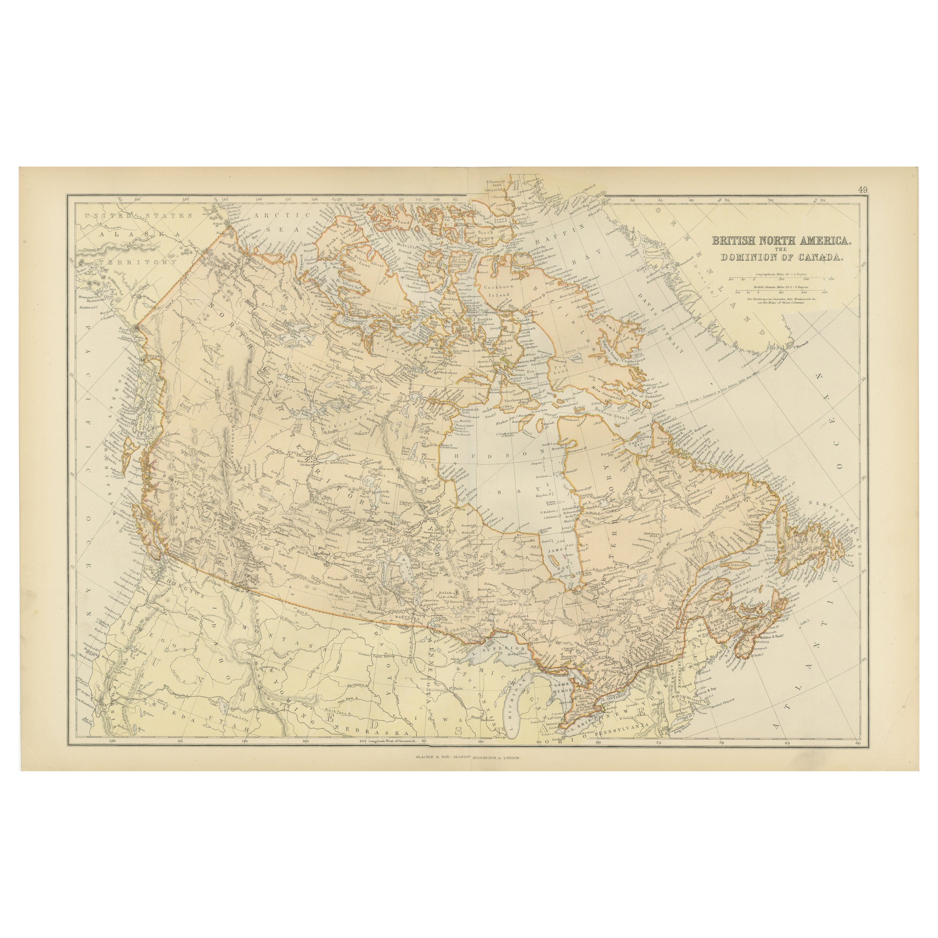
Antique Map of British North America, The Dominion of of Canada, 1882
Located in Langweer, NL
This map is titled "British North America, Dominion of Canada," from the 1882 Blackie Atlas. It features the geographical area that comprises modern-day Canada, with notable features...
Category
Antique 1880s Maps
Materials
Paper

You May Also Like
Antique Oarsman's Map of the River Thames, English, Cartography, Published 1912
Located in Hele, Devon, GB
This is an antique copy of The Oarsman's and Angler's Map of the River Thames - New Edition. An English, bound map book, published in English by Edward Stanford, London, this new edi...
Category
Early 20th Century British Other Books
Materials
Paper

Original Antique Map of the American State of Pennsylvania( Eastern Part ), 1903
Located in St Annes, Lancashire
Antique map of Pennsylvania ( Eastern part )
Published By A & C Black. 1903
Original colour
Good condition
Unframed.
Free shipping
Category
Antique Early 1900s English Maps
Materials
Paper

Original Antique Decorative Map of Iceland & Faroe, Fullarton, C.1870
Located in St Annes, Lancashire
Great map of Iceland and The Faroe Islands
Wonderful figural border
From the celebrated Royal Illustrated Atlas
Lithograph. Original color.
Published by Fullarton, Edinb...
Category
Antique 1870s Scottish Maps
Materials
Paper

London 1744 Published Watercolour Antique Map of East Africa by Eman Bowen
Located in West Sussex, Pulborough
We are delighted to offer for sale this New and Accurate Map of Nubia & Abissinia, together with all the Kingdoms Tributary Thereto, and bordering upon them published in 1744 by Emanuel Bowen
This is a decorative antique engraved map of East Africa...
Category
Antique 1740s English George III Maps
Materials
Paper

$1,028 Sale Price
20% Off
Antique Paterson's Guide to Britain, English, Maps, Georgian, Published 1811
Located in Hele, Devon, GB
This is an antique copy of Paterson's New and Accurate guide to Direct & Principal Crossroads. An English, bound book of maps and descriptive tables, published in English by Longman,...
Category
Antique Early 19th Century British Georgian Books
Materials
Paper

Antique North America Map, USA, Canada, Mexico, Cartography, Colton, Victorian
Located in Hele, Devon, GB
This is an antique North America map. A USA, framed lithography atlas engraving of the continent by JH Colton, dating to the Victorian period and later, circa 1860.
Fascinating, large framed map...
Category
Antique Mid-19th Century American Victorian Maps
Materials
Paper

Recently Viewed
View AllMore Ways To Browse
Antique Fishing Collectables
Antique Furniture Brunswick
Used Furniture Nova Scotia
Antique Furniture Newfoundland
Belgian Stone Top Tables
Bench Loveseat
Black French Desk Leather Top
Brass Gallery Tray
British Raj
Brown Corduroy Furniture
Brown Herman Miller Desk Chair
Bunching Tables
Canterbury Magazine Stand
Cardboard Armchair
Ceramic Organic Side Table
Charles Hollis Jones Lucite Coffee Table
Coffee Table French 1930s
Coffee Table Iron 1970