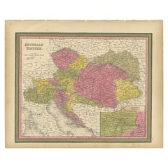
Colourful Old Map of the Austrian Empire, with an Inset Map of Vienna, 1846
View Similar Items


Want more images or videos?
Request additional images or videos from the seller
1 of 5
Colourful Old Map of the Austrian Empire, with an Inset Map of Vienna, 1846
About the Item
- Dimensions:Height: 13.78 in (35 cm)Width: 17.13 in (43.5 cm)Depth: 0 in (0.02 mm)
- Materials and Techniques:
- Period:
- Date of Manufacture:1846
- Condition:Wear consistent with age and use. Original/contemporary hand coloring. Age-related toning and some wear, mainly in margins. Blank verso, please study image carefully.
- Seller Location:Langweer, NL
- Reference Number:Seller: BG-12418-301stDibs: LU3054326812822
About the Seller
5.0
Recognized Seller
These prestigious sellers are industry leaders and represent the highest echelon for item quality and design.
Platinum Seller
Premium sellers with a 4.7+ rating and 24-hour response times
Established in 2009
1stDibs seller since 2017
2,417 sales on 1stDibs
Authenticity Guarantee
In the unlikely event there’s an issue with an item’s authenticity, contact us within 1 year for a full refund. DetailsMoney-Back Guarantee
If your item is not as described, is damaged in transit, or does not arrive, contact us within 7 days for a full refund. Details24-Hour Cancellation
You have a 24-hour grace period in which to reconsider your purchase, with no questions asked.Vetted Professional Sellers
Our world-class sellers must adhere to strict standards for service and quality, maintaining the integrity of our listings.Price-Match Guarantee
If you find that a seller listed the same item for a lower price elsewhere, we’ll match it.Trusted Global Delivery
Our best-in-class carrier network provides specialized shipping options worldwide, including custom delivery.More From This Seller
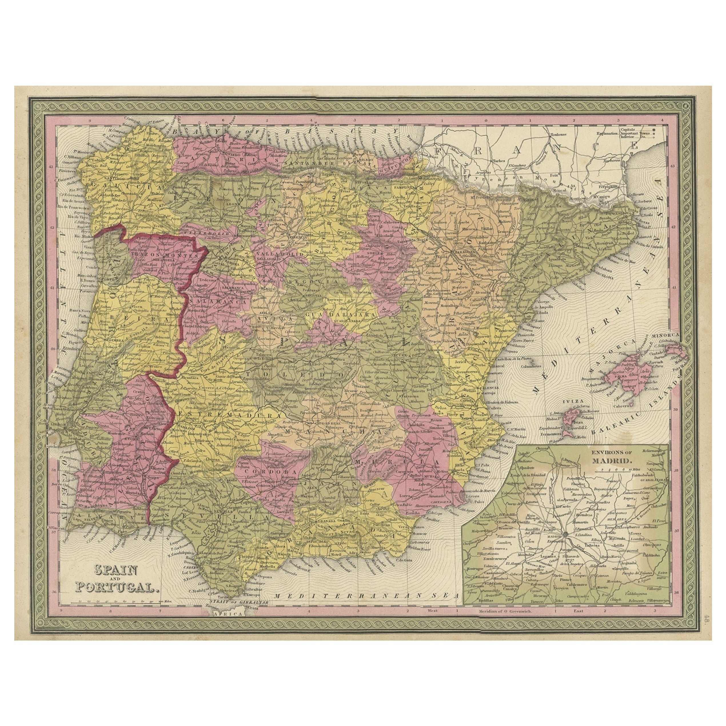
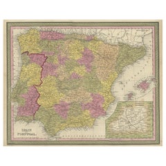
View AllOld Map of Spain and Portugal, with an Inset Map of the Region of Madrid, 1846
Located in Langweer, NL
Antique map titled 'Kingdom of Spain and Portugal'.
Old map of Spain and Portugal, with an inset map of the region of Madrid. This map originates from 'A New Universal Atlas Cont...
Category
Antique 1840s Maps
Materials
Paper
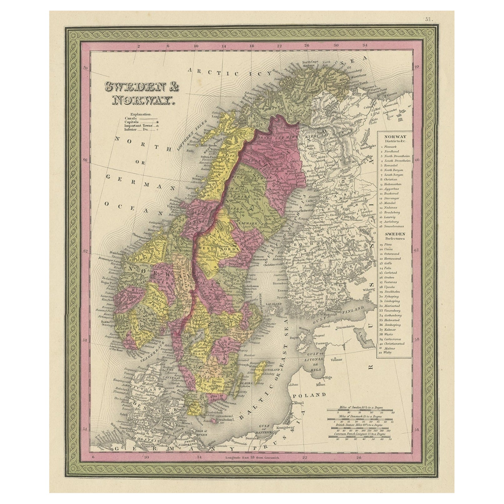
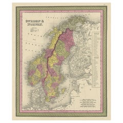
Old Colourful Map of Sweden and Norway, 1846
Located in Langweer, NL
Antique map titled 'Sweden & Norway'. Old map of Sweden and Norway.
This map originates from 'A New Universal Atlas Containing Maps of the various Em...
Category
Antique 1840s Maps
Materials
Paper
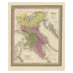
Old Antique Colourful Decorative Map of Northern Italy, 1846
Located in Langweer, NL
Description: Antique map titled 'Italy North Part'.
Old map of Northern Italy. This map originates from 'A New Universal Atlas Containing Maps of the various Empires, Kingdoms, S...
Category
Antique 1840s Maps
Materials
Paper
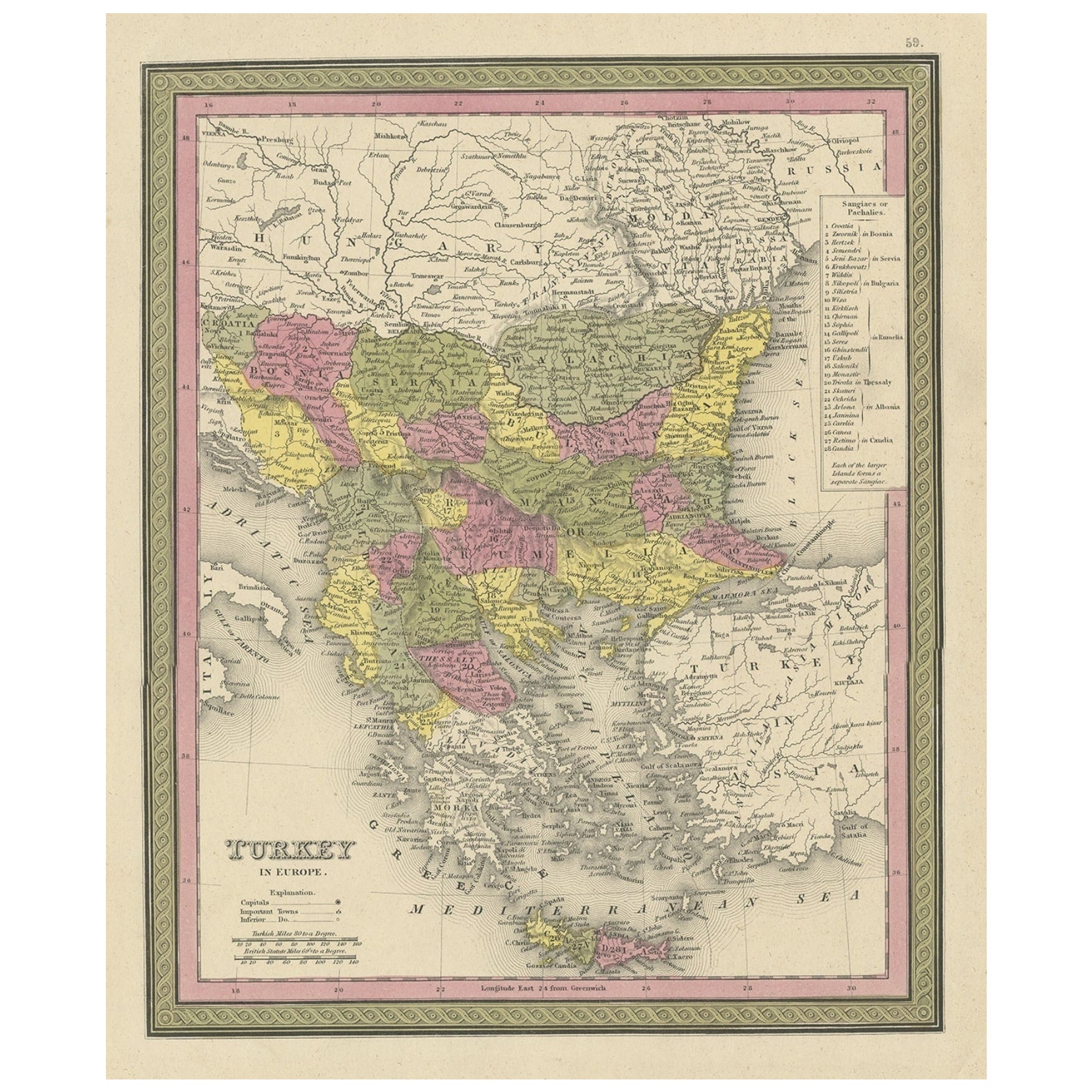
Old Colourful Decorative Map of Turkey in Europe, 1846
Located in Langweer, NL
Antique map titled 'Turkey in Europe'. Old map of Turkey in Europe.
This map originates from 'A New Universal Atlas Containing Maps of the various Em...
Category
Antique 1840s Maps
Materials
Paper
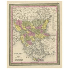
$213 Sale Price
20% Off
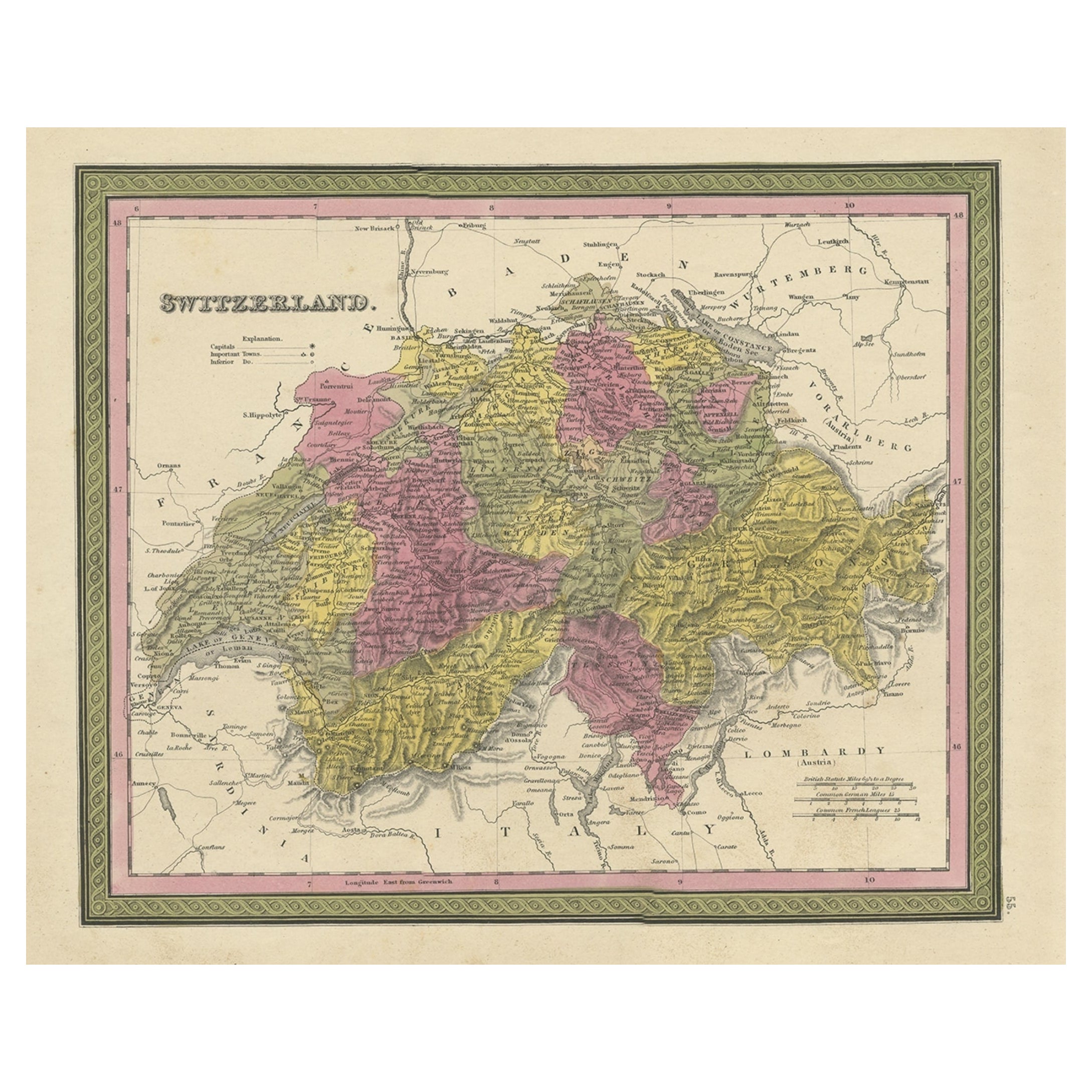
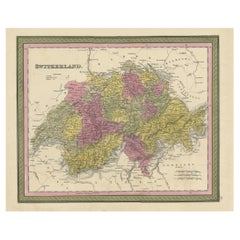
Colourful Antique Map of Switzerland, 1846
Located in Langweer, NL
Antique map titled 'Switzerland'. Old map of Switzerland.
This map originates from 'A New Universal Atlas Containing Maps of the various Empires...
Category
Antique 1840s Maps
Materials
Paper
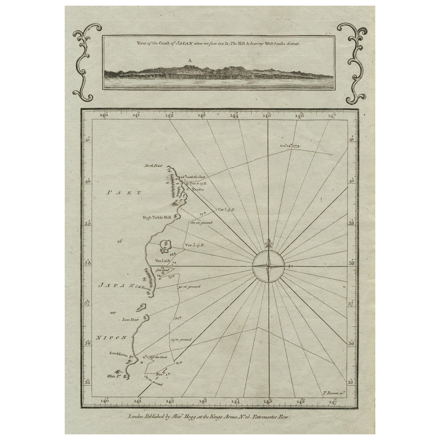
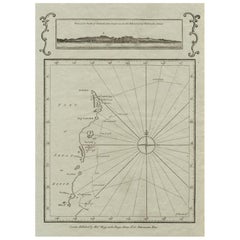
Old Map of the East Coast of Honshu with an Inset, Japan, c.1785
Located in Langweer, NL
Antique map titled ‘Part of Japan or Nippon'.
View of the Coast of Japan when we first saw it: The Hill a bearing West 3 miles distant. London Published by Allexer Hogg at the Kings Arms...
Category
Antique 1780s Maps
Materials
Paper
You May Also Like
Hand Colored 18th Century Homann Map of Austria Including Vienna and the Danube
By Johann Baptist Homann
Located in Alamo, CA
"Archiducatus Austriae inferioris" is a hand colored map of Austria created by Johann Baptist Homann (1663-1724) and published in Nuremberg, Germany in 1728 shortly after his death. ...
Category
Antique Early 18th Century German Maps
Materials
Paper

Old Horizontal Map of England
By Tasso
Located in Alessandria, Piemonte
ST/520 - Old rare Italian map of England, dated 1826-1827 - by Girolamo Tasso, editor in Venise, for the atlas of M.r Le-Sage.
Category
Antique Early 19th Century Italian Other Prints
Materials
Paper

An anatomical plaster model of the section of the head, Austria 1870.
Located in Milan, IT
An anatomical model of the section of the head, cast out of plaster, signed “ K.K.S.T.G.S.C.H Innsbruck, in a very good condition and with original patina. Anatomical study purpose. ...
Category
Antique Late 19th Century Austrian Scientific Instruments
Materials
Plaster

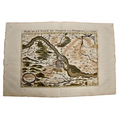
Vienna, Austria: A Large 17th Century Hand-Colored Map by Sanson and Jaillot
By Nicolas Sanson
Located in Alamo, CA
This large 17th century hand-colored map of Vienna, Austria and the surrounding countryside and villages entitled "Plan de la Ville de Vienne en Austrich...
Category
Antique 1690s French Maps
Materials
Paper
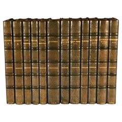
1846-1889 The Works of Alfred, Lord Tennyson
By Alfred Tennyson
Located in Bath, GB
A beautifully bound set of early and first editions of the works of Alfred, Lord Tennyson. Including seven first edition works.
A highly attractive set, in half morocco Zaehnsdorf b...
Category
Antique 19th Century British Books
Materials
Paper
1814 Map of "Russian Empire" Ric.r032
Located in Norton, MA
1814 Map of
"Russian Empire"
Ric.r032
Russian Empire. Description: This is an 1814 John Thomson map of the Russian Empire. The map depicts the region from the Baltic Sea, Prussia, and Sweden to the Aleutian Islands and from the Arctic Ocean to the Yellow River. Highly detailed, myriad cities, towns, and villages are labeled throughout, including St. Petersburg, Moscow, Minsk, Kiev, and Kharkov. Rivers and mountain ranges are also identified, as are islands and numerous locations along the coastlines. It is important to note that the long-disputed sea between Korea and Japan is identified as the 'Sea of Japan.
Historical Context:
In 1815, Tsarist Russia emerged from the Napoleonic Wars economically insolvent and politically fearful of the Revolutionary fervor that had just swept through Europe. In order to shore up Russia's economic position, the Tsars began an aggressive series of expansions into the Caucuses and Central Asia that would vastly increase the landmass of the Russian Empire.
Publication History
Thomson maps are known for their stunning color, awe inspiring size, and magnificent detail. Thomson's work, including this map, represents some of the finest cartographic art...
Category
Antique 19th Century Unknown Maps
Materials
Paper

Recently Viewed
View AllMore Ways To Browse
Metal High Top Stools
Metal Trolley On Wheels
Mid Century Chiavari Chairs
Mid Century Small Bar Cart
Mid Century Teak Serving Tray
Narrow White Tables
Oak Dining Table With Inlay
Oak Hall Bench
Oakwood Chair
Orange Tibetan Rugs
Orange Velvet Sofa
Painted Antique Pitcher
Painted Console Table With Drawers
Pair Palazzo Italy
Pedestal Dish
Pedestal Table With Lion Feet
Pomegranate Tree
Pretzel Rattan