Items Similar to Bay of Saint Helena: French Naval Chart by N.B. Ingénieur de la Marine, ca.1770


Want more images or videos?
Request additional images or videos from the seller
1 of 10
Bay of Saint Helena: French Naval Chart by N.B. Ingénieur de la Marine, ca.1770
About the Item
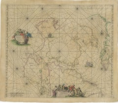
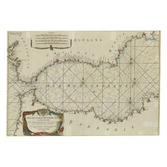
Bay of Saint Helena: French Naval Chart by N.B. Ingénieur de la Marine, 18th Century
This meticulously detailed copper engraving, titled 'Carte de la Baye de Sainte Helene' (Map of the Bay of Saint Helena), was drawn by N.B., an engineer of the French Navy (*Ingénieur de la Marine*). The map was created based on the navigational observations of mariners and published in the 18th century, most likely in France. It offers a precise and practical representation of Saint Helena Bay, a crucial anchorage point in the South Atlantic Ocean.
Saint Helena Bay, located on the island of Saint Helena, was an important stopover for ships sailing between Europe and Asia, particularly for Dutch and British vessels during the Age of Exploration and the later colonial period. Its significance was further heightened when the island became the final exile location of Napoleon Bonaparte from 1815 to 1821.
The map shows the bay with impressive attention to detail, depicting the coastline with numerous soundings marked in French and English leagues (*Lieues Marines de France et d'Angleterre*), allowing navigators to gauge the water depth and avoid hazards. The bay’s natural topography, including hills and coastal elevations, is rendered in delicate engraving lines. A large central peak dominates the landscape, surrounded by rugged terrain, while a smaller inlet and river (*Riviere*) are also shown, highlighting the complex geography of the bay.
A decorative fleur-de-lis compass rose marks the left side of the chart, indicating orientation and providing a clear sense of direction for mariners. The map's clean and elegant design reflects the French cartographic tradition of combining functional navigation aids with aesthetic appeal.
The chart includes practical features such as scale indicators and coastal profiles that help sailors recognize the bay from a distance. The detailed soundings marked throughout the bay make this map an invaluable tool for understanding the navigational challenges of the area, particularly for large, heavily laden ships.
This rare chart belongs to a series of marine maps produced during the 18th century, capturing the strategic and geographic significance of Saint Helena during a period when European powers vied for control over global trade routes. Such maps not only served as practical guides for mariners but also as scientific documents reflecting the advancements in naval cartography and maritime exploration.
Condition: The map is in good condition, with minimal foxing and clear, crisp engraving lines. The paper is well-preserved, maintaining its original texture and quality.
Framing tips: To enhance the historical appeal and protect its condition, consider framing the chart with a classic dark wood or ebony frame, complemented by a cream or light tan mat that underscores the print’s maritime heritage and antique charm.
- Dimensions:Height: 9.85 in (25 cm)Width: 7.49 in (19 cm)Depth: 0.01 in (0.2 mm)
- Materials and Techniques:Paper,Engraved
- Period:1770-1779
- Date of Manufacture:circa 1170
- Condition:Condition: The map is in good condition, with minimal foxing and clear, crisp engraving lines. The paper is well-preserved, maintaining its original texture and quality.
- Seller Location:Langweer, NL
- Reference Number:Seller: BG-035211stDibs: LU3054344140952
About the Seller
5.0
Recognized Seller
These prestigious sellers are industry leaders and represent the highest echelon for item quality and design.
Platinum Seller
Premium sellers with a 4.7+ rating and 24-hour response times
Established in 2009
1stDibs seller since 2017
2,417 sales on 1stDibs
Typical response time: <1 hour
- ShippingRetrieving quote...Shipping from: Langweer, Netherlands
- Return Policy
Authenticity Guarantee
In the unlikely event there’s an issue with an item’s authenticity, contact us within 1 year for a full refund. DetailsMoney-Back Guarantee
If your item is not as described, is damaged in transit, or does not arrive, contact us within 7 days for a full refund. Details24-Hour Cancellation
You have a 24-hour grace period in which to reconsider your purchase, with no questions asked.Vetted Professional Sellers
Our world-class sellers must adhere to strict standards for service and quality, maintaining the integrity of our listings.Price-Match Guarantee
If you find that a seller listed the same item for a lower price elsewhere, we’ll match it.Trusted Global Delivery
Our best-in-class carrier network provides specialized shipping options worldwide, including custom delivery.More From This Seller
View All1690 Frederick de Wit Sea Chart of Hudson Bay, Baffin Bay and Greenland
Located in Langweer, NL
Title: c. 1690 Frederick de Wit Sea Chart of Hudson Bay, Baffin Bay, and Greenland - Engraved by Romeyn de Hooghe
This striking sea chart by Frederick de Wit, titled "Septemtrionali...
Category
Antique 1690s Maps
Materials
Paper
Antique Print with Charts of York's Bay and Surroundings
Located in Langweer, NL
Antique map titled 'Côte depuis la Baye d'York (..)'. Charts of York's Bay, Haven of the Three Islands, St. David's Bay, and Elizabeth's Bay.
Published in an edition of John Hawk...
Category
Antique Late 18th Century Maps
Materials
Paper
Antique Map of France by Kitchin, c.1770
Located in Langweer, NL
Antique map titled 'France'. Original antique map of France. Source unknown, to be determined.
Artists and Engravers: Thomas Kitchin (or Thomas Kitchen (1718 - 1784) was an Englis...
Category
Antique 18th Century Maps
Materials
Paper
Charting the Course of Empire: Bonne's 1770 Masterpiece Maps of the Indian Ocean
Located in Langweer, NL
A voyage through history with an exquisite collection of Rigobert Bonne's 1770 maps, as featured in the coveted Atlas Moderne circa 1770. Each map, a cartographic treasure, captures ...
Category
Antique 1770s Maps
Materials
Paper
$568 / set
Free Shipping
Large Decorative Antique Map of the Mediterranean, ca.1770
Located in Langweer, NL
Antique map titled 'Carte de la Mer Mediterranee en Douze Feuilles'.
First map out of twelve fine engraved double-page and folding maps that join to create a large wall map...
Category
Antique 1770s Maps
Materials
Paper
$1,058 Sale Price
20% Off
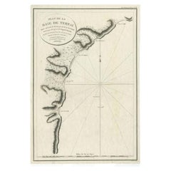
Antique Map of the Bay of Terney by La Pérouse, 1797
Located in Langweer, NL
Antique map titled 'Plan de la Baie de Ternai'. Old map of the north eastern coast of Russia. This map originates from 'Atlas du voyage de La Perouse'. Arti...
Category
Antique 18th Century Maps
Materials
Paper
You May Also Like
1898 Chart of Boston Bay
Located in Norwell, MA
Original 1898 chart showing Massachusetts Bay with the coast from Cape Ann to Cape Cod. This is a U.S. Navy Geodetic survey chart. All towns are noted along the coast. Framed with gl...
Category
Antique 1890s Nautical Objects
Materials
Paper

$1,495
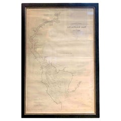
1889 Sea Chart Map of Delaware Bay by George Eldridge, Chart No. 11
Located in Colorado Springs, CO
Presented is an original Eldridge's Chart No. 11, Delaware Bay and River, from The United States Coast and George Eldridge's Surveys, published in 1889. The sea chart shows the Delaw...
Category
Antique 1880s Maps
Materials
Paper
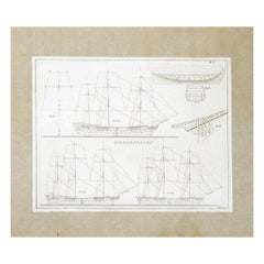
Frederick Chapman: ‘Naval Architecture War Vessels’, circa 1770
Located in Lymington, Hampshire
FREDERICK CHAPMAN: ‘Naval Architecture War Vessels’, circa 1770, , 50 engraved plates of various sizes depicting naval diagrams (numbered I-XXVI), four signed ‘F. Ringheim’and one ea...
Category
Antique 18th Century Swedish Books
Materials
Paper
French Mahogany Barometer with Thermometer by "L'Ingenieur Chevallier"
By Jean Gabriel Augustin Chevallier
Located in Pembroke, MA
Impressive French mahogany barometer and thermometer from the Louis-Philippe period (Circa 1840), by Jean Gabriel Augustin Chevalliier. The barometer features an indicator arrow adju...
Category
Antique 19th Century French Louis Philippe Scientific Instruments
Materials
Metal, Bronze

1847 The Naval History of Great Britain, from the Declaration of War by France
By William James (Author)
Located in Bath, GB
A beautiful edition of naval historian William James's detailed and richly illustrated history of the Royal Navy.
A 'New Edition' of naval historian William James's impressive work,...
Category
Antique 1840s British Books
Materials
Paper

Jeux de la grenouille, French Frog Game
Located in Copenhagen K, DK
Super fun French game, called Jeux de la grenouille, involving throwing. Pine game and cast iron frogs. Get the disc in the frogs’ mouths!
Category
Early 20th Century French Other Games
Materials
Iron
$2,228 Sale Price / set
20% Off
Recently Viewed
View AllMore Ways To Browse
Napoleon Engraving
18th Century Naval
British Compass
Colonial Ebony
Dutch Ebony Frames
Used Furniture Anchorage
Antique Furniture Anchorage
Napoleon Hill
Coastal Ebony
Scandinavian Wood Tray
Scroll Leg Stool
Set Of Staffordshire
Sheepskin Study Chairs
Small Antique Prayer Rug
Spinning Chair
Sweden Rack
The Lord Vintage Furniture
Trolley Oak