Items Similar to Antique Original Map of the City of Deventer, the Netherlands, 1588

Want more images or videos?
Request additional images or videos from the seller
1 of 5
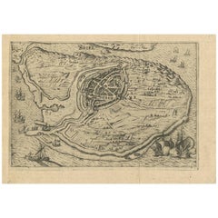
Antique Original Map of the City of Deventer, the Netherlands, 1588
About the Item
Antique map titled 'Liberae et Hanseaticae urbis Daventriensis delineatio'.
Original bird's eye plan of the Dutch hanseatic city Deventer, on the situated IJssel river. This map originates from Braun & Hogenberg's 'Civitates Orbis Terrarum', 1588 Artists and Engravers: Georg Braun (1542-1622), a German publisher and Frans Hogenberg issued the famous six volume town book "Civitates Orbis Terrarum" between 1572 and 1618. The volumes originally published in Latin, follow by German and French translations. Franz Hogenberg (1533-1588) was the son of a Munich engraver who settled in Malines. He engraved most of the plates for Ortelius' Theatrum and the majority of those in the Civitates, and may have been responsible for originating the project. Worked and died in Cologne/Germany. He was a prolific copper engraver and etching artist of maps and town views. In cooperation with Georg Braun he created the first four volumes of the Civitates Orbis Terrarum in 1572.
Artist: Georg Braun (1542-1622), a German publisher and Frans Hogenberg issued the famous six volume town book "Civitates Orbis Terrarum" between 1572 and 1618. The volumes originally published in Latin, follow by German and French translations. Franz Hogenberg (1533-1588) was the son of a Munich engraver who settled in Malines. He engraved most of the plates for Ortelius' Theatrum and the majority of those in the Civitates, and may have been responsible for originating the project. Worked and died in Cologne/Germany. He was a prolific copper engraver and etching artist of maps and town views. In cooperation with Georg Braun he created the first four volumes of the Civitates Orbis Terrarum in 1572.
Condition: Very good, Latin text on verso. Please study image carefully.
Date: 1588
Overall size: 52 x 39.5 cm.
Image size: 41.5 x 34 cm.
Antique prints have long been appreciated for both their aesthetic and investment value. They were the product of engraved, etched or lithographed plates. These plates were handmade out of wood or metal, which required an incredible level of skill, patience and craftsmanship. Whether you have a house with Victorian furniture or more contemporary decor an old engraving can enhance your living space.
- Dimensions:Height: 15.56 in (39.5 cm)Width: 20.48 in (52 cm)Depth: 0 in (0.01 mm)
- Materials and Techniques:
- Period:
- Date of Manufacture:1588
- Condition:Condition: Very good, Latin text on verso. Please study image carefully.
- Seller Location:Langweer, NL
- Reference Number:Seller: BGI-010821stDibs: LU3054327774092
About the Seller
5.0
Recognized Seller
These prestigious sellers are industry leaders and represent the highest echelon for item quality and design.
Platinum Seller
Premium sellers with a 4.7+ rating and 24-hour response times
Established in 2009
1stDibs seller since 2017
2,419 sales on 1stDibs
Typical response time: <1 hour
- ShippingRetrieving quote...Shipping from: Langweer, Netherlands
- Return Policy
Authenticity Guarantee
In the unlikely event there’s an issue with an item’s authenticity, contact us within 1 year for a full refund. DetailsMoney-Back Guarantee
If your item is not as described, is damaged in transit, or does not arrive, contact us within 7 days for a full refund. Details24-Hour Cancellation
You have a 24-hour grace period in which to reconsider your purchase, with no questions asked.Vetted Professional Sellers
Our world-class sellers must adhere to strict standards for service and quality, maintaining the integrity of our listings.Price-Match Guarantee
If you find that a seller listed the same item for a lower price elsewhere, we’ll match it.Trusted Global Delivery
Our best-in-class carrier network provides specialized shipping options worldwide, including custom delivery.More From This Seller
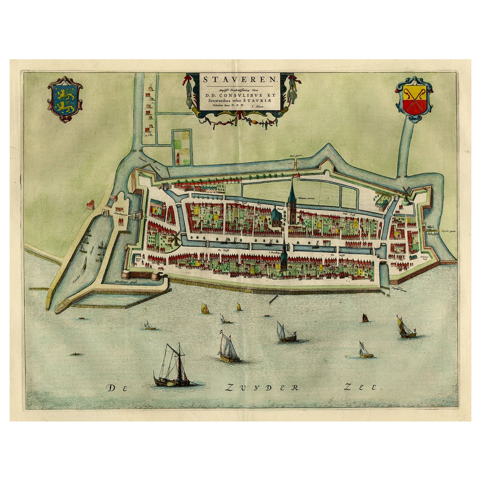
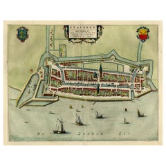
View AllOriginal Antique Map of the City of Stavoren, Friesland, The Netherlands, 1649
Located in Langweer, NL
Antique map titled 'Staveren'. Original antique map of the city of Stavoren, Friesland, The Netherlands. This map originates from 'Toonneel der Steden van de Vereenighde Nederlanden'...
Category
Antique 1640s Maps
Materials
Paper
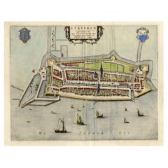
Original Antique Map of the City of Stavoren, Friesland, The Netherlands, 1649
Located in Langweer, NL
Antique map titled 'Staveren'. Original antique map of the city of Stavoren, Friesland, The Netherlands. This map originates from 'Toonneel der Steden van de Vereenighde Nederlanden'...
Category
Antique 1640s Maps
Materials
Paper
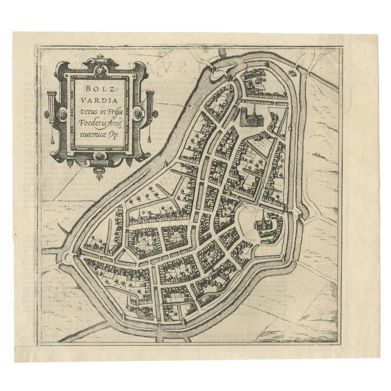
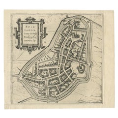
Antique Map of the City of Bolsward, Friesland in The Netherlands, c.1598
Located in Langweer, NL
Antique map titled ‘Bolzvardia vetus in Frisia Foederis (..)’. Old map of the city of Bolsward, Friesland. Originally part of a sheet together with the cities of Stavoren, Harlingen ...
Category
Antique 16th Century Maps
Materials
Paper
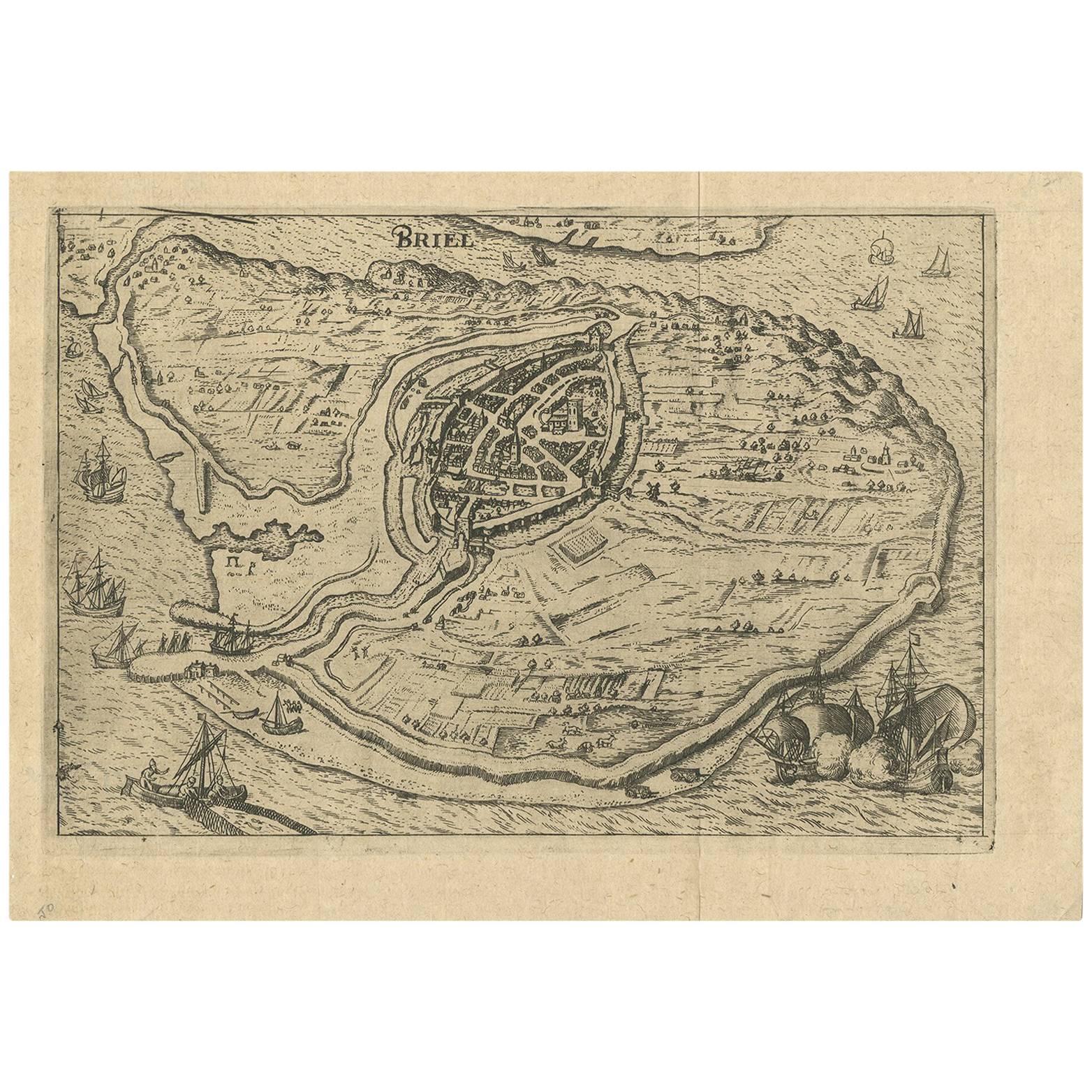
Antique Map of the City of Brielle 'The Netherlands' by L. Guicciardini, 1625
Located in Langweer, NL
Plan of Brielle, Briel, Den Briel in the Province of Zuid-Holland, The Netherlands, Holland. This map originates from the 1625 edition of 'Discrittione di tutti i Paesi Bassi', by L....
Category
Antique Early 17th Century Maps
Materials
Paper
$139 Sale Price
33% Off
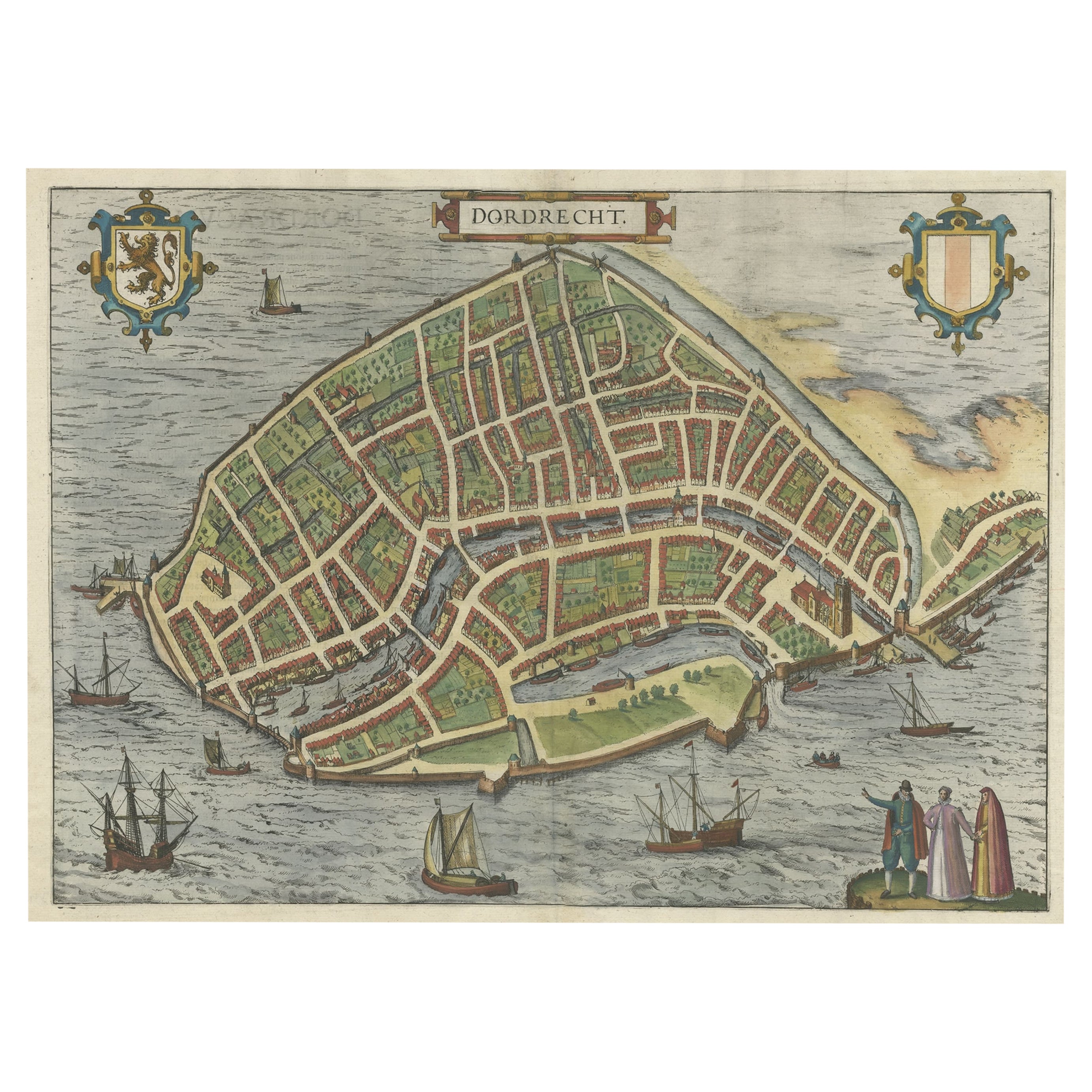
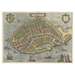
Beautiful Decorative Antique Map of the City of Dordrecht, the Netherlands, 1581
Located in Langweer, NL
Antique map titled 'Dordrecht'.
Map of the city of Dordrecht, the Netherlands. Bird's-eye plan view of the city, with many ships and two coats of arms in upper corners. This map ...
Category
Antique 16th Century Maps
Materials
Paper
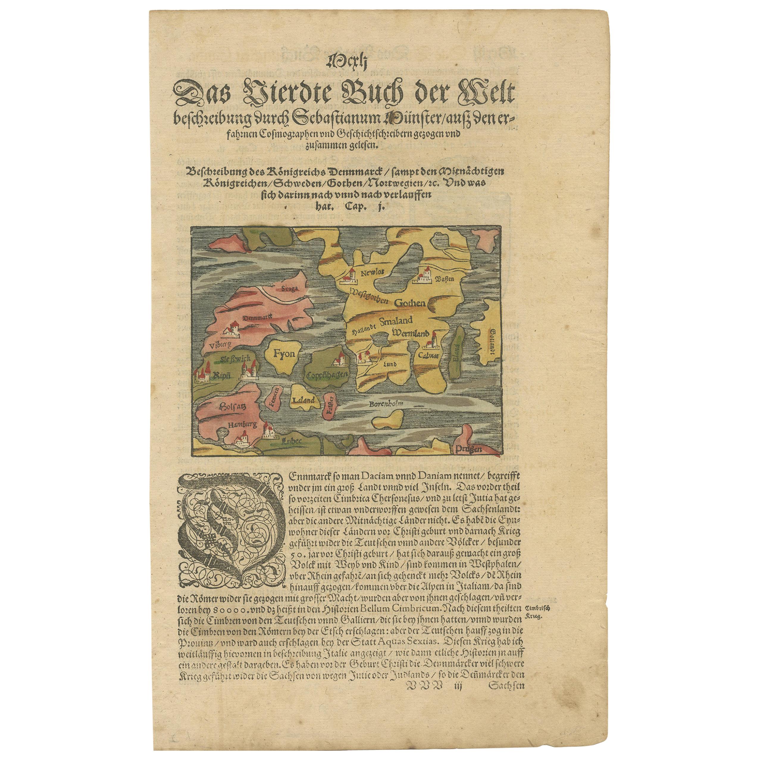
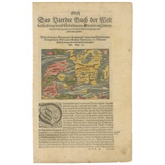
Antique Map of Denmark by Münster '1588'
Located in Langweer, NL
Antique map titled 'Beschreibung des Königreichs Dennmarck (..)'. Early map of Denmark. This map originates from 'Cosmographey Oder beschreibung Aller Länder (..)' by Sebastian Münster.
Category
Antique 16th Century Maps
Materials
Paper
You May Also Like
Original Antique Map of The World by Thomas Clerk, 1817
Located in St Annes, Lancashire
Great map of The Eastern and Western Hemispheres
On 2 sheets
Copper-plate engraving
Drawn and engraved by Thomas Clerk, Edinburgh.
Published by Mackenzie And Dent, 1817
...
Category
Antique 1810s English Maps
Materials
Paper

Original Antique Map of Europe, Arrowsmith, 1820
Located in St Annes, Lancashire
Great map of Europe
Drawn under the direction of Arrowsmith.
Copper-plate engraving.
Published by Longman, Hurst, Rees, Orme and Brown, 1820
...
Category
Antique 1820s English Maps
Materials
Paper

Original Antique Map of Ireland- Kerry. C.1840
Located in St Annes, Lancashire
Great map of Kerry
Steel engraving
Drawn under the direction of A.Adlard
Published by How and Parsons, C.1840
Unframed.
Category
Antique 1840s English Maps
Materials
Paper

Original Antique Map of China, Arrowsmith, 1820
Located in St Annes, Lancashire
Great map of China
Drawn under the direction of Arrowsmith
Copper-plate engraving
Published by Longman, Hurst, Rees, Orme and Brown, 1820
Unfr...
Category
Antique 1820s English Maps
Materials
Paper

Original Antique Map of Hungary, Arrowsmith, 1820
Located in St Annes, Lancashire
Great map of Hungary
Drawn under the direction of Arrowsmith.
Copper-plate engraving.
Published by Longman, Hurst, Rees, Orme and Brown, 1820
Unframed.
Category
Antique 1820s English Maps
Materials
Paper

Original Antique Map of South America. C.1780
Located in St Annes, Lancashire
Great map of South America
Copper-plate engraving
Published C.1780
Two small worm holes to left side of map
Unframed.
Category
Antique Early 1800s English Georgian Maps
Materials
Paper

Recently Viewed
View AllMore Ways To Browse
Antique City View Engravings
Victorian Holland And Son
Walnut Base Swivel Chair
Walnut Solid Wood Pedestal
Walnut Tilt Table
White Lacquered Writing Table
Wine Pitchers
Wood Table Library Desk
Yellow Majolica Plates
10 X 13 Vintage Wool Rug
1970s Stainless Steel Chairs
2 X 16 Rug
24 Inch Lounge Chair
52 Inch Table
Adrian Couch
Angora Turkish Oushak Rug
Antique Primitive Chair
Antique Queen Anne Chairs