Items Similar to Antique Map of Spain and Part of Africa by Kiepert, C.1870

Want more images or videos?
Request additional images or videos from the seller
1 of 5
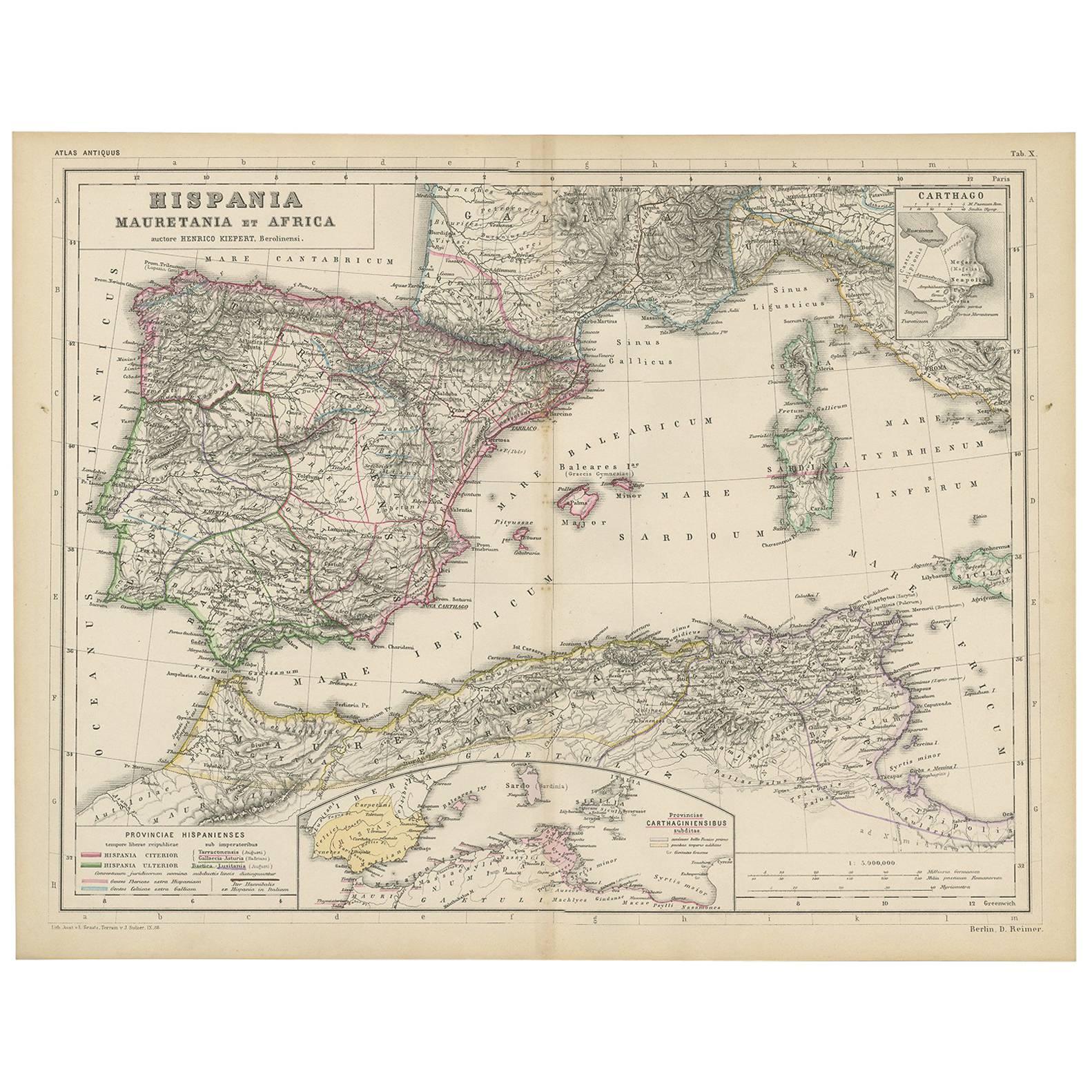
Antique Map of Spain and Part of Africa by Kiepert, C.1870
About the Item
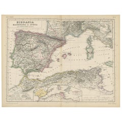
"Antique map titled 'Hispania Mauretania et Africa'. Old map of Spain, also depicting part of Africa. This map originates from 'Atlas Antiquus, twaalf kaarten behoorende bij de Oude Geschiedenis'. Artists and Engravers: Kiepert, Heinrich (1818-1899), was a German geographer, and the son of a wealthy businessman.
Artist: Kiepert, Heinrich (1818-1899), was a German geographer, and the son of a wealthy businessman.
Antique prints have long been appreciated for both their aesthetic and investment value. They were the product of engraved, etched or lithographed plates. These plates were handmade out of wood or metal, which required an incredible level of skill, patience and craftsmanship. Whether you have a house with Victorian furniture or more contemporary decor an old engraving can enhance your living space. We offer a wide range of authentic antique prints for any budget."
- Dimensions:Height: 13.82 in (35.1 cm)Width: 17.92 in (45.5 cm)Depth: 0 in (0.01 mm)
- Materials and Techniques:
- Period:
- Date of Manufacture:circa 1870
- Condition:Condition: Good, general age-related toning. Split on folding line, please study image carefully.
- Seller Location:Langweer, NL
- Reference Number:Seller: BG-06670-191stDibs: LU3054327675022
About the Seller
5.0
Recognized Seller
These prestigious sellers are industry leaders and represent the highest echelon for item quality and design.
Platinum Seller
Premium sellers with a 4.7+ rating and 24-hour response times
Established in 2009
1stDibs seller since 2017
2,417 sales on 1stDibs
Typical response time: <1 hour
- ShippingRetrieving quote...Shipping from: Langweer, Netherlands
- Return Policy
Authenticity Guarantee
In the unlikely event there’s an issue with an item’s authenticity, contact us within 1 year for a full refund. DetailsMoney-Back Guarantee
If your item is not as described, is damaged in transit, or does not arrive, contact us within 7 days for a full refund. Details24-Hour Cancellation
You have a 24-hour grace period in which to reconsider your purchase, with no questions asked.Vetted Professional Sellers
Our world-class sellers must adhere to strict standards for service and quality, maintaining the integrity of our listings.Price-Match Guarantee
If you find that a seller listed the same item for a lower price elsewhere, we’ll match it.Trusted Global Delivery
Our best-in-class carrier network provides specialized shipping options worldwide, including custom delivery.More From This Seller
View AllAntique Map of Spain, Mauritia and Africa by H. Kiepert, circa 1870
By Heinrich Kiepert
Located in Langweer, NL
Antique map titled 'Hispania, Mauretania et Africa'. This map originates from 'Atlas Antiquus. Zwölf Karten zur Alten Geschichte' by H. Kiepert. Published in Berlin, circa 1870.
Category
Antique Late 19th Century Maps
Materials
Paper
$139 Sale Price
20% Off
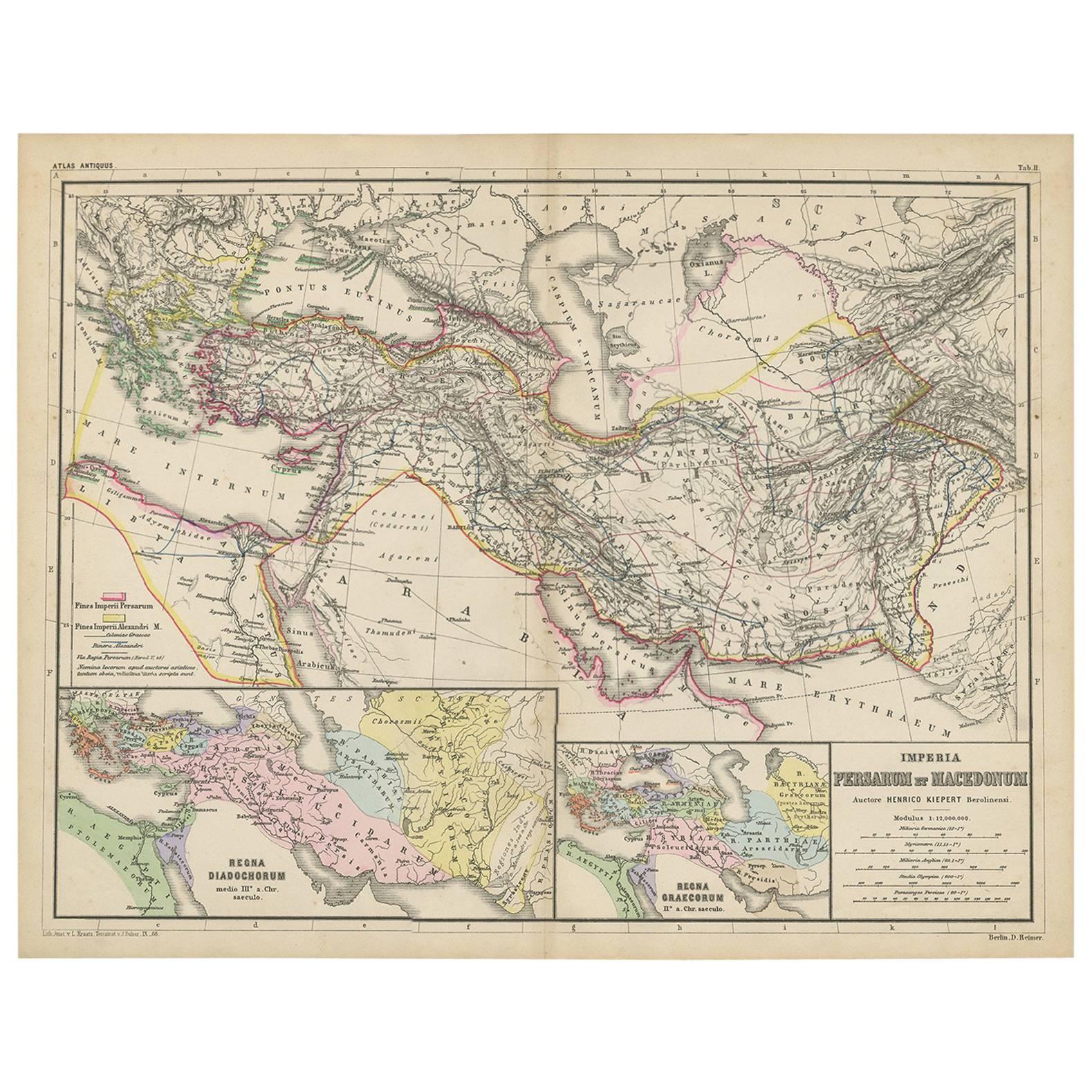
Antique Map of Part of the Roman Empire by H. Kiepert, circa 1870
By Heinrich Kiepert
Located in Langweer, NL
Antique map titled 'Imperia Persarum et Macedonum'. Depicts part of the Roman Empire, from Greece to Eastern India. This map originates from 'Atlas Antiqus. Zwölf Karten zur Alten Ge...
Category
Antique Late 19th Century Maps
Materials
Paper

$139 Sale Price
20% Off
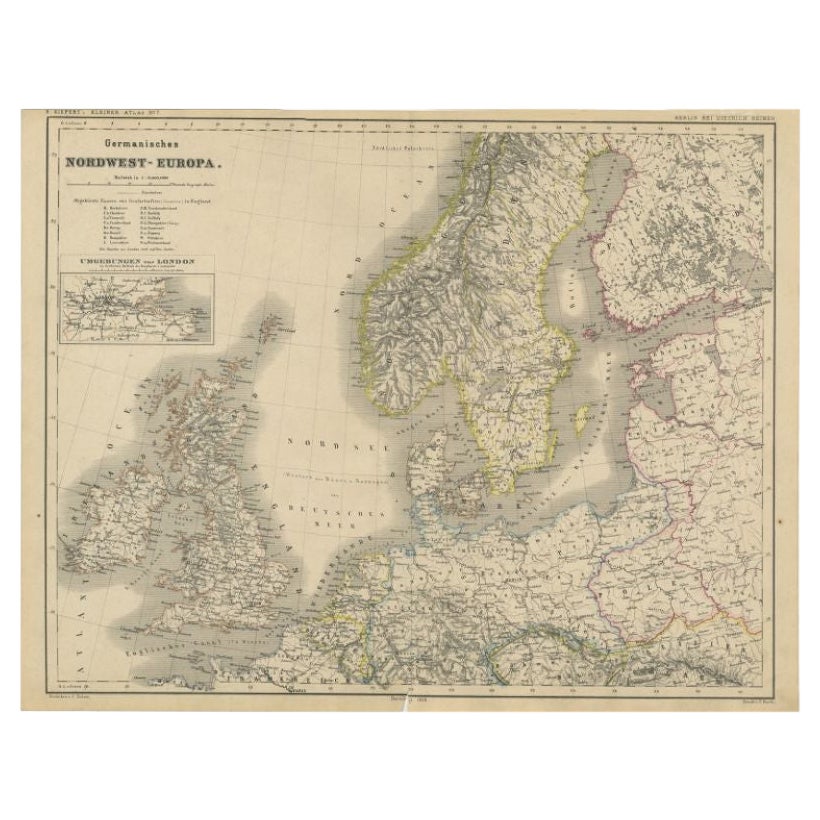
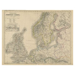
Antique Map of Northwest Europe by Kiepert, c.1870
Located in Langweer, NL
Antique map titled 'Germanisches Nordwest-Europa'. Old map of North-West Europe depicting the United Kingdom, Ireland, the Netherlands, Germany, Scandinavia and surroundings. This ma...
Category
Antique 19th Century Maps
Materials
Paper
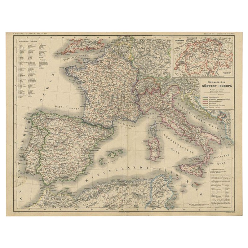
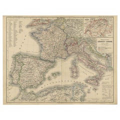
Antique Map of Southwest Europe by Kiepert, c.1870
Located in Langweer, NL
"Antique map titled 'Romanisches Südwest-Europa'. Old map of Southwest Europe. This map originates from 'H. Kiepert's Kleiner Atlas der Neueren Geographie für Schule und Haus'. Artis...
Category
Antique 19th Century Maps
Materials
Paper
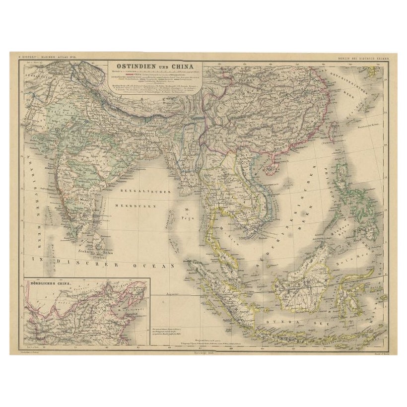
Antique Map of Southeast Asia and China by Kiepert, c.1870
By Thomas Kitchin
Located in Langweer, NL
Antique map titled 'Ostindien und China'. Old map of Southeast Asia and China. This map originates from 'H. Kiepert's Kleiner Atlas der Neueren Geographie für Schule und Haus'. Artis...
Category
Antique 19th Century Maps
Materials
Paper

Antique Map of Egypt and Palestina by H. Kiepert 'circa 1870'
By Heinrich Kiepert
Located in Langweer, NL
Antique map titled 'Aegyptus, Phoenice et Palestina'. With inset maps of Tyrus, Alexandria and Hierosolyma. This map originates from 'Atlas Antiquus. Zwölf Karten zur Alten Geschicht...
Category
Antique Late 19th Century Maps
Materials
Paper

$148 Sale Price
20% Off
You May Also Like
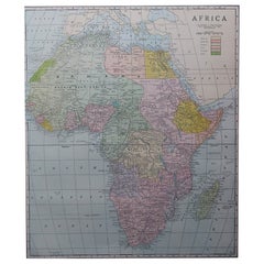
Large Original Antique Map of Africa. C.1900
Located in St Annes, Lancashire
Fabulous map of Africa
Original color.
Engraved and printed by the George F. Cram Company, Indianapolis.
Published, C.1900.
Unframed.
Free shipping.
Category
Antique 1890s American Maps
Materials
Paper
Large Original Antique Map of Java and Borneo, Fullarton, C.1870
Located in St Annes, Lancashire
Great map of Java and Borneo
Wonderful figurative borders
From the celebrated Royal Illustrated Atlas
Lithograph. Original color.
Published by Fullarton, Edinburgh. C.1870
Unfr...
Category
Antique 1870s Scottish Maps
Materials
Paper

Original Antique Map of Spain and Portugal, circa 1790
Located in St Annes, Lancashire
Super map of Spain and Portugal
Copper plate engraving by A. Bell
Published, circa 1790.
Unframed.
Category
Antique 1790s English Other Maps
Materials
Paper

Original Antique Decorative Map of Iceland & Faroe, Fullarton, C.1870
Located in St Annes, Lancashire
Great map of Iceland and The Faroe Islands
Wonderful figural border
From the celebrated Royal Illustrated Atlas
Lithograph. Original color.
Published by Fullarton, Edinb...
Category
Antique 1870s Scottish Maps
Materials
Paper

Original Antique Map of South Africa, Arrowsmith, 1820
Located in St Annes, Lancashire
Great map of South Africa.
Drawn under the direction of Arrowsmith.
Copper-plate engraving.
Published by Longman, Hurst, Rees, Orme and Br...
Category
Antique 1820s English Maps
Materials
Paper

Large Original Antique Map of The World, Fullarton, C.1870
Located in St Annes, Lancashire
Great map of the World. Showing both hemispheres
From the celebrated Royal Illustrated Atlas
Lithograph. Original color.
Published by Fullarton, Edinburgh, C.1870
Unframed.
Rep...
Category
Antique 1870s Scottish Maps
Materials
Paper

Recently Viewed
View AllMore Ways To Browse
African Plate
Heinrich Germany Plates
Set Of 2 Club Chairs
Silk Ikat Pillow
Silver Fish Box
Sloped Sofa
Small Marble Tray
Small Organic Console Tables
Socle Wood
Sofas And Chairs Store
Solid Brass And Glass Console
Square Oak End Table
Stone Round Feet
Suspenders Vintage
Swedish Library Table
Teak Wood Bench Andrianna
Thistle Glass
Tiger Skin Rug