Items Similar to Antique Map of Senegal, West Africa

Want more images or videos?
Request additional images or videos from the seller
1 of 6
Antique Map of Senegal, West Africa
About the Item
Original antique map titled 'Carta del Senegal'. Antique map of Senegal, West Africa. This map originates from 'Compendio della storia generale dei viaggi (..)'. Published by De la Harpe, 1781.
- Dimensions:Height: 10.04 in (25.5 cm)Width: 14.49 in (36.8 cm)Depth: 0.02 in (0.5 mm)
- Materials and Techniques:
- Period:
- Date of Manufacture:1781
- Condition:Wear consistent with age and use. General age-related toning. Shows wear and creasing, blank verso. Please study image carefully.
- Seller Location:Langweer, NL
- Reference Number:Seller: BG-13188-61stDibs: LU3054331132352
About the Seller
5.0
Recognized Seller
These prestigious sellers are industry leaders and represent the highest echelon for item quality and design.
Platinum Seller
Premium sellers with a 4.7+ rating and 24-hour response times
Established in 2009
1stDibs seller since 2017
2,418 sales on 1stDibs
Typical response time: <1 hour
- ShippingRetrieving quote...Shipping from: Langweer, Netherlands
- Return Policy
Authenticity Guarantee
In the unlikely event there’s an issue with an item’s authenticity, contact us within 1 year for a full refund. DetailsMoney-Back Guarantee
If your item is not as described, is damaged in transit, or does not arrive, contact us within 7 days for a full refund. Details24-Hour Cancellation
You have a 24-hour grace period in which to reconsider your purchase, with no questions asked.Vetted Professional Sellers
Our world-class sellers must adhere to strict standards for service and quality, maintaining the integrity of our listings.Price-Match Guarantee
If you find that a seller listed the same item for a lower price elsewhere, we’ll match it.Trusted Global Delivery
Our best-in-class carrier network provides specialized shipping options worldwide, including custom delivery.More From This Seller
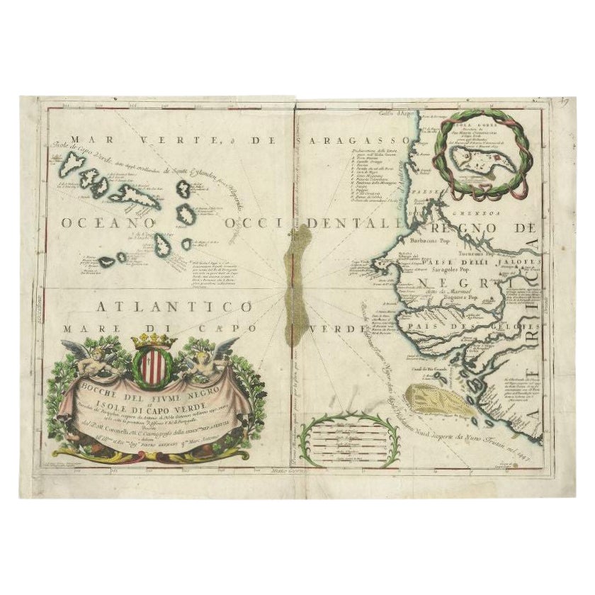
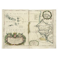
View AllAntique Map of the Cape Verde Islands and Part of Senegal, West Africa, 1690
Located in Langweer, NL
Antique map titled 'Bocche del Fivme Negro et Isole di Capo Verde'. Beautiful double-page map of the Cape Verde Islands and part of the coast of Senegal, with large decorative cartou...
Category
Antique 17th Century Maps
Materials
Paper
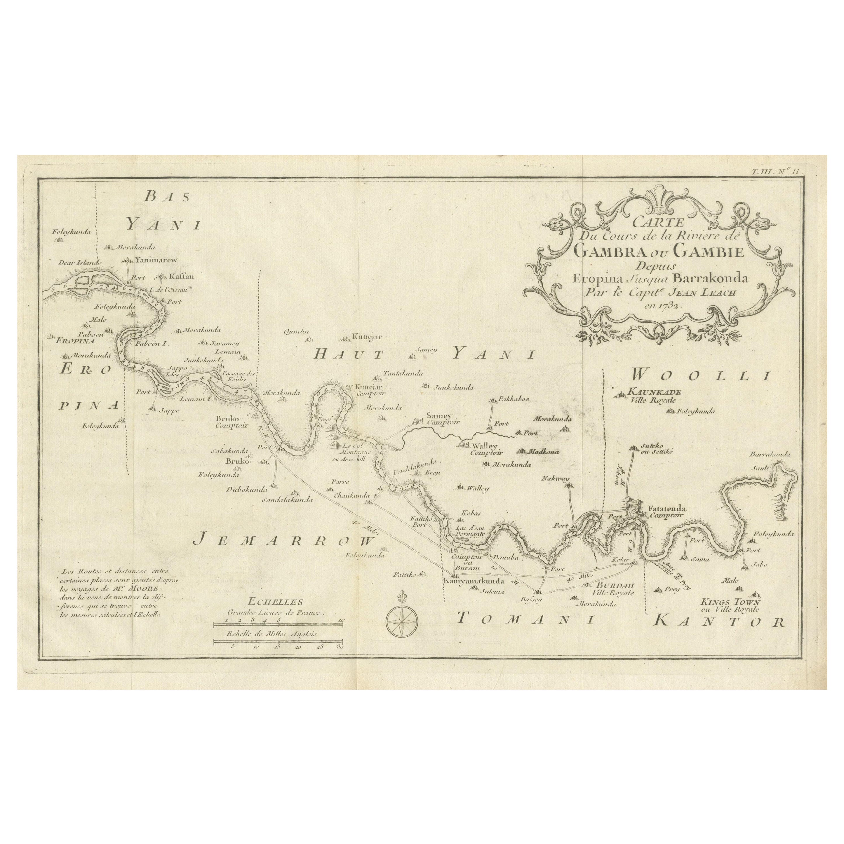
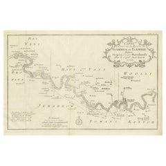
Antique Map of Gambia, West Africa
Located in Langweer, NL
Antique map titled 'Carte du Cours de la Riviere de Gambra ou Gambie (..)'. Detailed map of Gambia, West Africa, surrounded by Senegal with decorative title based on information supp...
Category
Antique Mid-18th Century Maps
Materials
Paper
Antique Map of West Africa by R. Bonne, 1780
Located in Langweer, NL
Antique map titled 'Partie Occidentale De L'Ancien Continent Depuis Lisbonne Jusqua La Riviere De Sierra Leona Avec L'Isle de Madere, les Isles Canaries et celles Du Cap Verd'. Parts...
Category
Antique Late 18th Century Maps
Materials
Paper

$162 Sale Price
22% Off
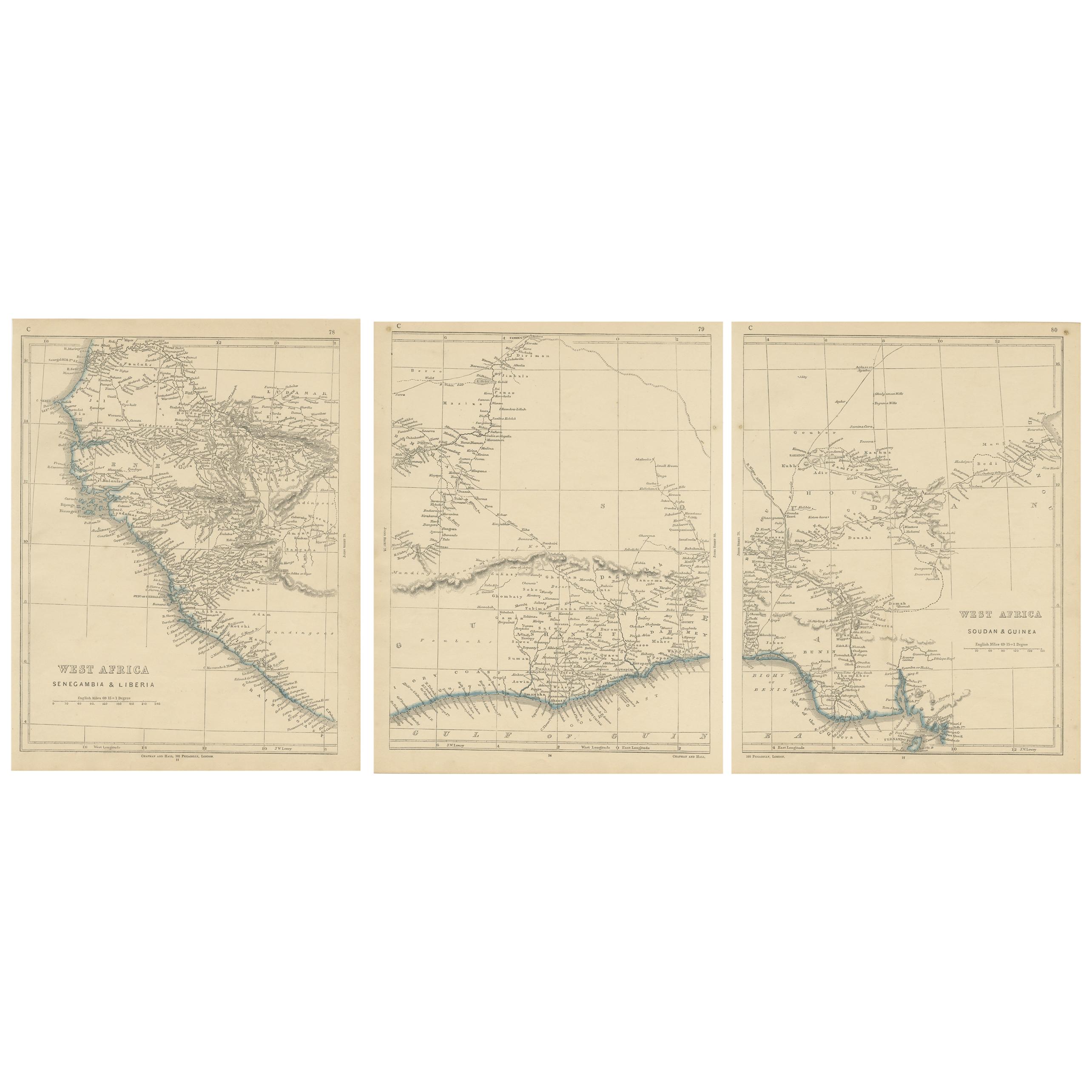
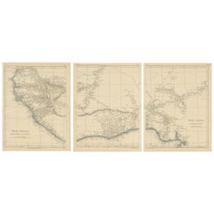
Antique Map of West Africa by Lowry, 1852
Located in Langweer, NL
Antique map titled 'West Africa'. Three individual sheets of West Africa. This map originates from 'Lowry's table Atlas constructed and engraved from the most recent authorities' by ...
Category
Antique Mid-19th Century Maps
Materials
Paper
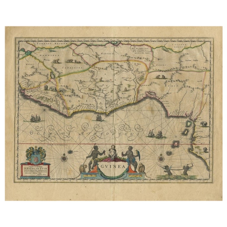
Antique Map of Guinea in West Africa by Blaeu, c.1638
Located in Langweer, NL
Antique map titled 'Guinea'.
Decorative map of West Africa, including numerous animals in the interior, sailing ships and several elegant cartouches. Both the map and the sea are s...
Category
Antique 17th Century Maps
Materials
Paper
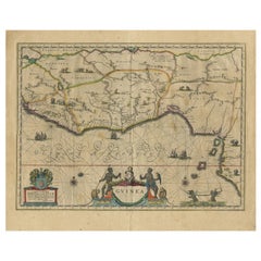
$511 Sale Price
20% Off
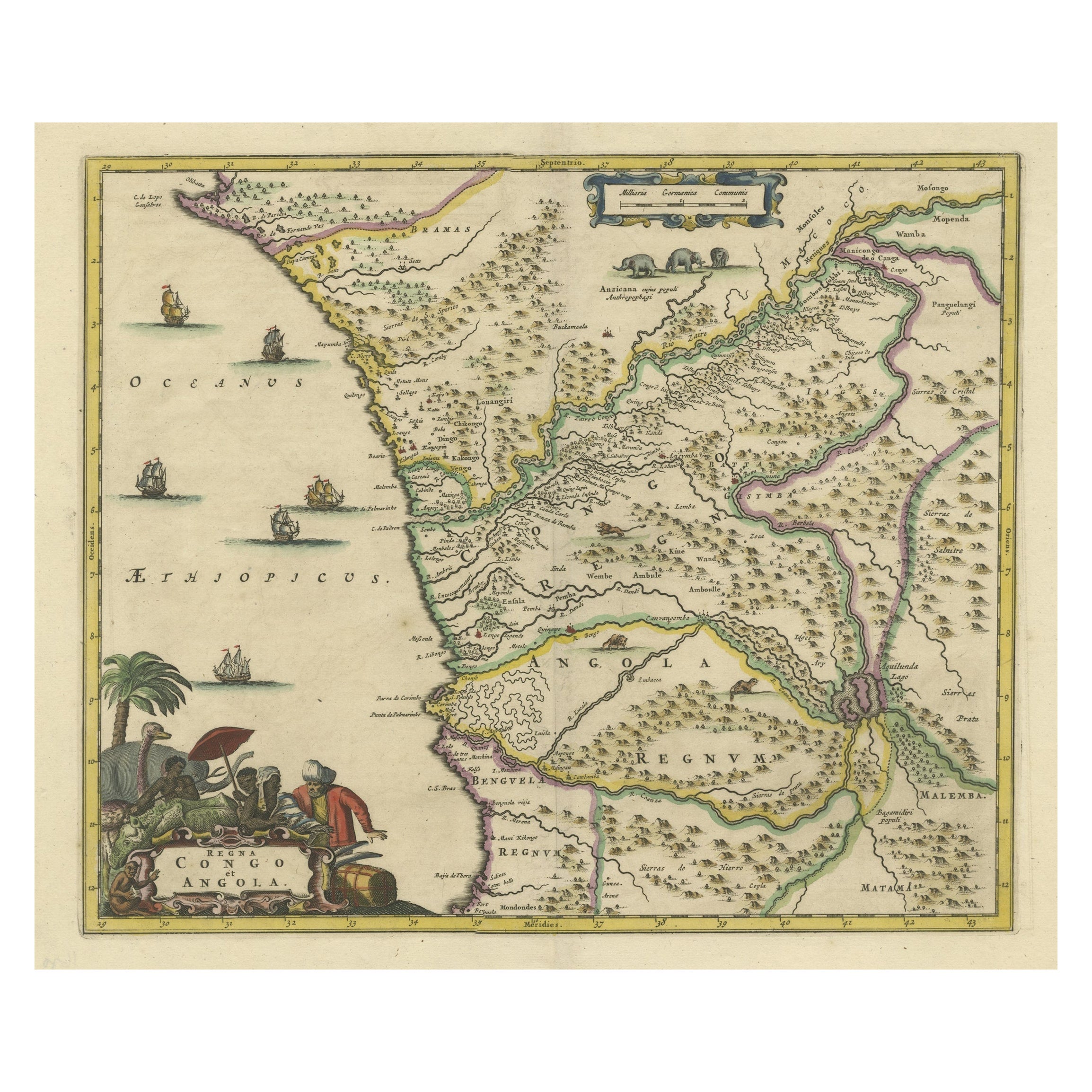
Antique Map of West Africa, focused on the Congo and Angola
Located in Langweer, NL
Original antique map titled 'Regna Congo et Angola'. Decorative 17th Century English map of a portion of West Africa, focused on the Congo and Angola. The map is centered on the Zair...
Category
Antique Late 17th Century Maps
Materials
Paper
You May Also Like
Original Antique Map of South Africa, Arrowsmith, 1820
Located in St Annes, Lancashire
Great map of South Africa.
Drawn under the direction of Arrowsmith.
Copper-plate engraving.
Published by Longman, Hurst, Rees, Orme and Br...
Category
Antique 1820s English Maps
Materials
Paper

West Coast of Africa, Guinea & Sierra Leone: An 18th Century Map by Bellin
By Jacques-Nicolas Bellin
Located in Alamo, CA
Jacques Bellin's copper-plate map entitled "Partie de la Coste de Guinee Dupuis la Riviere de Sierra Leona Jusquau Cap das Palmas", depicting the coast of Guinea and Sierra Leone in ...
Category
Antique Mid-18th Century French Maps
Materials
Paper

West Africa Entitled "Guinea Propria": An 18th Century Hand Colored Homann Map
By Johann Baptist Homann
Located in Alamo, CA
This is a scarce richly hand colored copper plate engraved map of Africa entitled "Guinea Propria, nec non Nigritiae vel Terrae Nigrorum Maxima Pars" by Johann Baptist Homann (1664-1...
Category
Antique Mid-18th Century German Maps
Materials
Paper

Antique Map of Principality of Monaco
By Antonio Vallardi Editore
Located in Alessandria, Piemonte
ST/619 - "Old Geographical Atlas of Italy - Topographic map of ex-Principality of Monaco" -
ediz Vallardi - Milano -
A somewhat special edition ---
Category
Antique Late 19th Century Italian Other Prints
Materials
Paper

17th Century Hand-Colored Map of a Region in West Germany by Janssonius
By Johannes Janssonius
Located in Alamo, CA
This attractive highly detailed 17th century original hand-colored map is entitled "Archiepiscopatus Maghdeburgensis et Anhaltinus Ducatus cum terris adjacentibus". It was published ...
Category
Antique Mid-17th Century Dutch Maps
Materials
Paper

"Nova Barbariae Descriptio", a 17th Century Hand-Colored Map of North Africa
By Johannes Janssonius
Located in Alamo, CA
This original attractive 17th century hand-colored map of North Africa entitled "Nova Barbariae Descriptio" by Johannes Janssonius was published in Paris in 1635. It includes the Med...
Category
Antique Mid-17th Century Dutch Maps
Materials
Paper

Recently Viewed
View AllMore Ways To Browse
Handmade Turkey Decoration
Herman Miller Orange
High Back Throne Chair
Italian Carved Walnut Center Table
Italian Gilt Table Mirror
Italian Reclining Lounge Chair
Jansen Plant Stand
Knoll Eero Saarinen Tulip Dining
Kpm Porcelain Hand Painted
Lacquer Plinth Table
Laminate Top End Table
Large Neutral Oushak Rugs
Large Regency Console
Lis Chair
Lis Chairs
Long Painted Console Table
Louis Xv Style Side Tables With Marble Top
Lustre China