Items Similar to Antique Map of the Queen Charlotte Islands, Haida Gwaii


Want more images or videos?
Request additional images or videos from the seller
1 of 6
Antique Map of the Queen Charlotte Islands, Haida Gwaii
About the Item
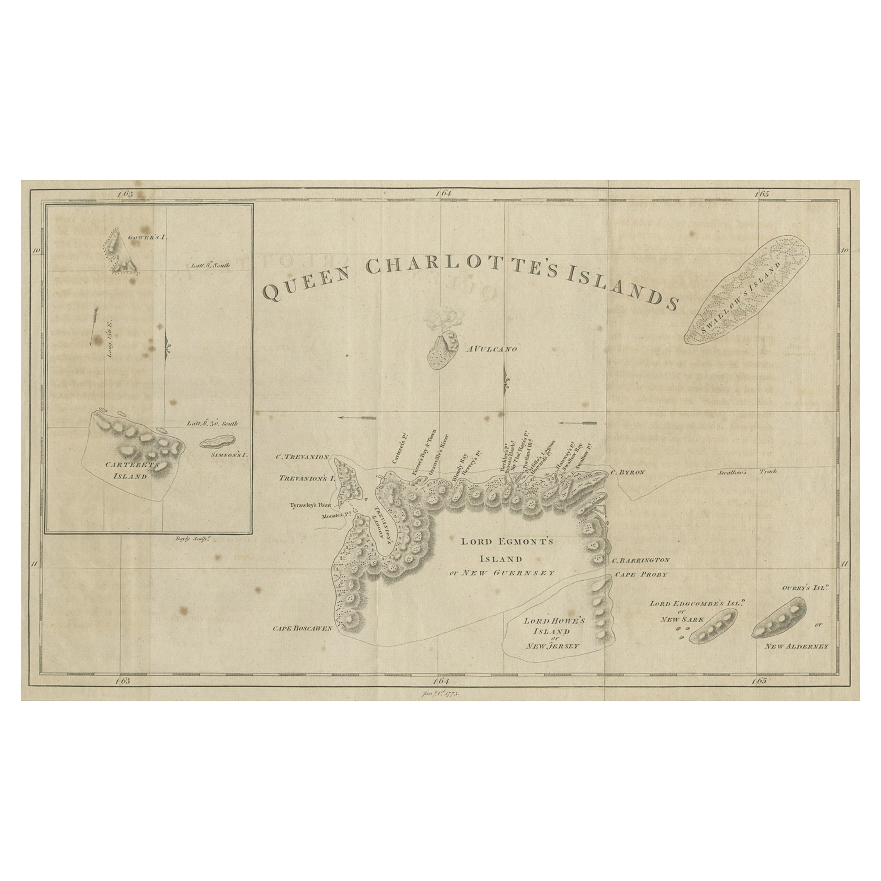
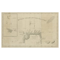
Antique map titled 'Isles de la Reine Charlotte (..)'. Original old map of the Queen Charlotte Islands, based upon the explorations of James Cook, Juan Perez, and other contemporary European explorers. The map shows only partial coastal detail along the north end of the main island, and includes two insets of navigable bays and depth measurements.
Now called Haida Gwaii, after the local native population, the islands situated off Canada’s coast, south of Vancouver played an important role in the late 18th and early 19th century maritime fur trade. The name “Queen Charlotte” was given from the name of a British merchant ship engaged in the fur trade who visited in the island two years prior to publication, in 1785.
Published by Rigobert Bonne, circa 1787.
- Dimensions:Height: 10.71 in (27.2 cm)Width: 16.34 in (41.5 cm)Depth: 0.02 in (0.5 mm)
- Materials and Techniques:
- Period:
- Date of Manufacture:1787
- Condition:General age-related toning. Original folding line, with split. Shows wear and soiling. Blank verso. Please study image carefully.
- Seller Location:Langweer, NL
- Reference Number:Seller: BG-12707-951stDibs: LU3054334290932
About the Seller
5.0
Recognized Seller
These prestigious sellers are industry leaders and represent the highest echelon for item quality and design.
Platinum Seller
Premium sellers with a 4.7+ rating and 24-hour response times
Established in 2009
1stDibs seller since 2017
2,415 sales on 1stDibs
Typical response time: 1 hour
- ShippingRetrieving quote...Shipping from: Langweer, Netherlands
- Return Policy
Authenticity Guarantee
In the unlikely event there’s an issue with an item’s authenticity, contact us within 1 year for a full refund. DetailsMoney-Back Guarantee
If your item is not as described, is damaged in transit, or does not arrive, contact us within 7 days for a full refund. Details24-Hour Cancellation
You have a 24-hour grace period in which to reconsider your purchase, with no questions asked.Vetted Professional Sellers
Our world-class sellers must adhere to strict standards for service and quality, maintaining the integrity of our listings.Price-Match Guarantee
If you find that a seller listed the same item for a lower price elsewhere, we’ll match it.Trusted Global Delivery
Our best-in-class carrier network provides specialized shipping options worldwide, including custom delivery.More From This Seller
View AllAntique Map of the Islands Within the Queen Charlotte's Islands
Located in Langweer, NL
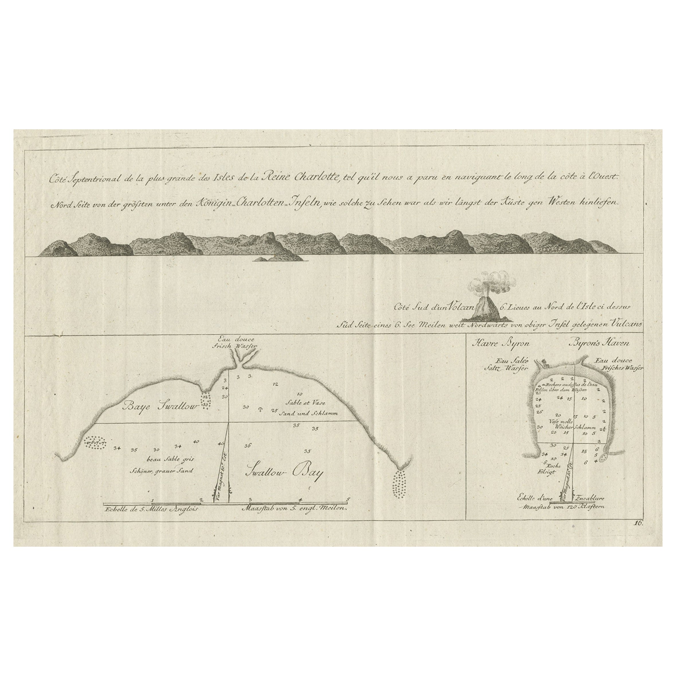
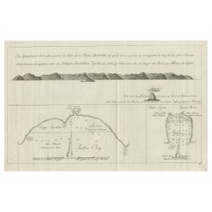
Antique map titled 'Cote Septentrional de la plus grande des Isles de la Reine Charlotte (..)'. Map and coastal view of the islands within the Queen Charlotte's Islands (Santa Cruz I...
Category
Antique Late 18th Century Maps
Materials
Paper

Map of Queen Charlotte's, Carteret's, Simson's and Gower's Islands, Canada, 1773
Located in Langweer, NL
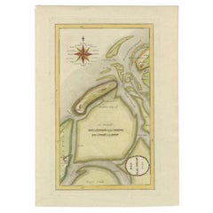
Antique map Canada titled 'Queen Charlotte's Islands'.
Old map of Queen Charlotte's Islands, Canada. With an inset map of Carteret's, Simson's a...
Category
Antique 1770s Maps
Materials
Paper
Old View of the Queen Charlotte's Islands 'Santa Cruz Islands, Solomon', 1774
Located in Langweer, NL
Antique map titled 'Cote Septentrional de la plus grande des Isles de la Reine Charlotte (..)'.
Map and coastal view of the islands within the Queen Charlotte's Islands (Santa Cruz Islands...
Category
Antique 1770s Maps
Materials
Paper
$332 Sale Price
20% Off
Antique Map of the Atlantic Islands, 1817
Located in Langweer, NL
Antique map titled 'Atlantic Islands'. Large map of the Atlantic Islands include the Cape Verde islands, Canary islands, Azore islands and Madeira islands. Also included a view of th...
Category
Antique Early 19th Century Maps
Materials
Paper

Antique Map of the Wadden Islands, 1792
Located in Langweer, NL
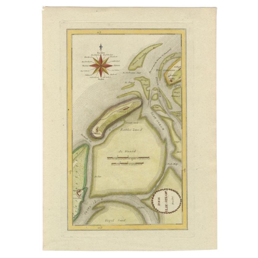
Antique map titled 'Der Vlie Strom'. Map of the Wadden islands with Vlieland in the middle (The Netherlands). This map originates from 'Schauplatz der fünf Theile der Welt' published...
Category
Antique 18th Century Maps
Materials
Paper
Antique Map of the Island of Java, Indonesia
Located in Langweer, NL
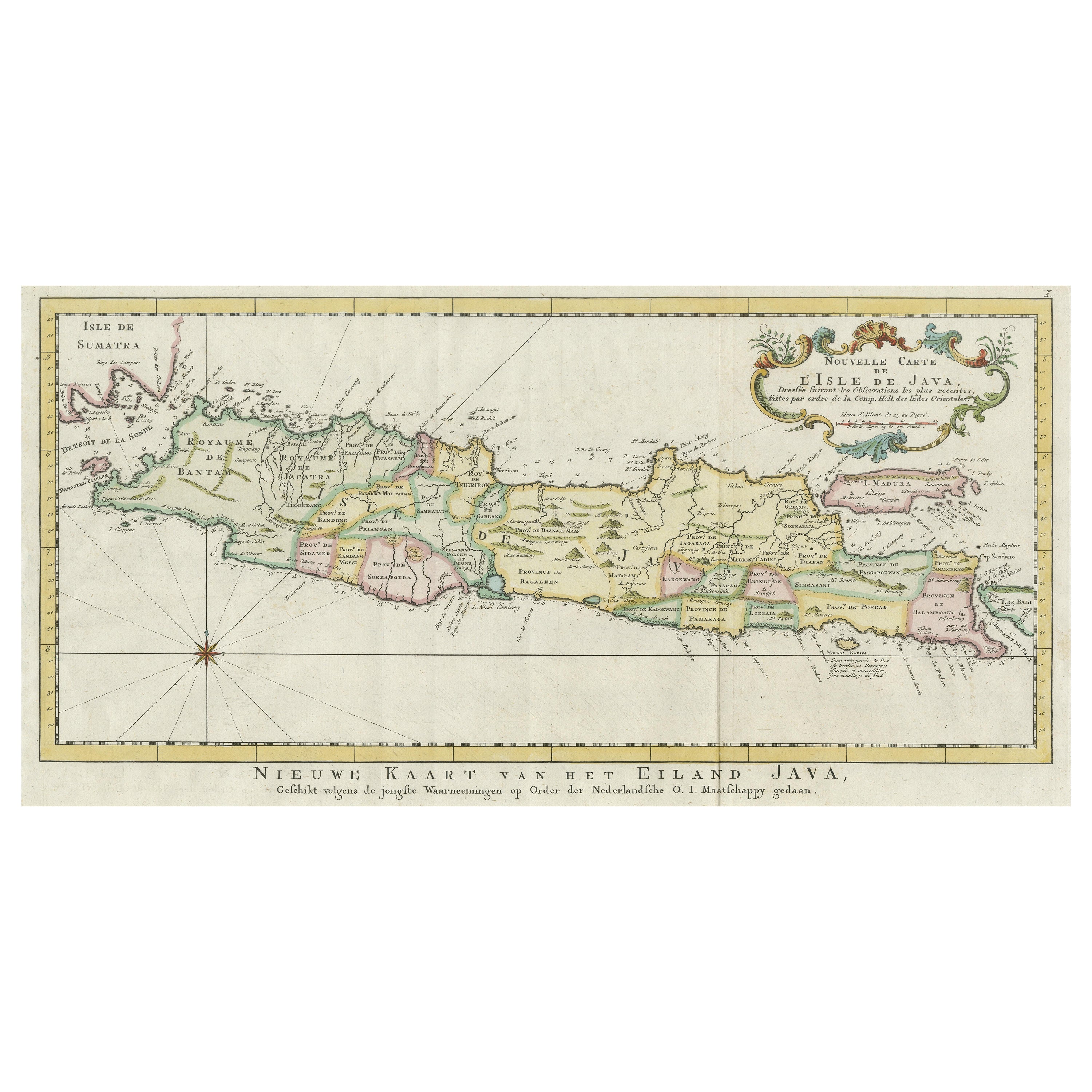
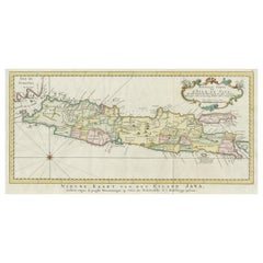
Antique map titled 'Nouvelle Carte de l'Isle de Java (..) - Nieuwe Kaart van het Eiland Java (..)'. Chart of the island of Java, depicting soundings around the coast, all principal h...
Category
Antique Late 18th Century Maps
Materials
Paper
$415 Sale Price
20% Off
You May Also Like
Large Original Antique Map of the The Windward Islands. 1894
Located in St Annes, Lancashire
Superb Antique map of The Windward Islands
Published Edward Stanford, Charing Cross, London 1894
Original colour
Good condition
Unframed.
Free shipping
Category
Antique 1890s English Maps
Materials
Paper

Large Original Antique Map of The Greek Islands. 1894
Located in St Annes, Lancashire
Superb Antique map of The Greek Islands
Published Edward Stanford, Charing Cross, London 1894
Original colour
Good condition
Unframed.
Free shipping
Category
Antique 1890s English Maps
Materials
Paper

Large Original Antique Map of The Leeward Islands. 1894
Located in St Annes, Lancashire
Superb Antique map of The Leeward Islands
Published Edward Stanford, Charing Cross, London 1894
Original colour
Good condition
Unframed.
Free shipping
Category
Antique 1890s English Maps
Materials
Paper

Large Original Antique Map of The Falkland Islands. 1894
Located in St Annes, Lancashire
Superb Antique map of The Falkland Islands
Published Edward Stanford, Charing Cross, London 1894
Original colour
Good condition
Unframed.
Free shipping
Category
Antique 1890s English Maps
Materials
Paper

Large Original Antique Map of The Canary Islands. 1894
Located in St Annes, Lancashire
Superb Antique map of The Canary Islands
Published Edward Stanford, Charing Cross, London 1894
Original colour
Good condition
Unframed.
Free shipping
Category
Antique 1890s English Maps
Materials
Paper

Original Antique Map of the American State of Connecticut & Rhode Island, 1903
Located in St Annes, Lancashire
Antique map of Connecticut and Rhode Island
Published By A & C Black. 1903
Original colour
Good condition
Unframed.
Free shipping
Category
Antique Early 1900s English Maps
Materials
Paper

Recently Viewed
View AllMore Ways To Browse
Queen Charlotte
Used Furniture North Bay
18th Century Canadian Furniture
Coffee Pot Deco
Collector Spoons
Colorful Bench
Conform Chair
Console Table With Birds
Croatian Artist
Cylindrical Ottoman
Diamond Back Chair
Dining Chairs 8 Traditional
Draped Marble Table
Draw Leaf Table
Drop Leaf Gate Leg Table
Dyer Gems
Egg And Dart Table
Enamel Kitchen Table Vintage