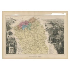
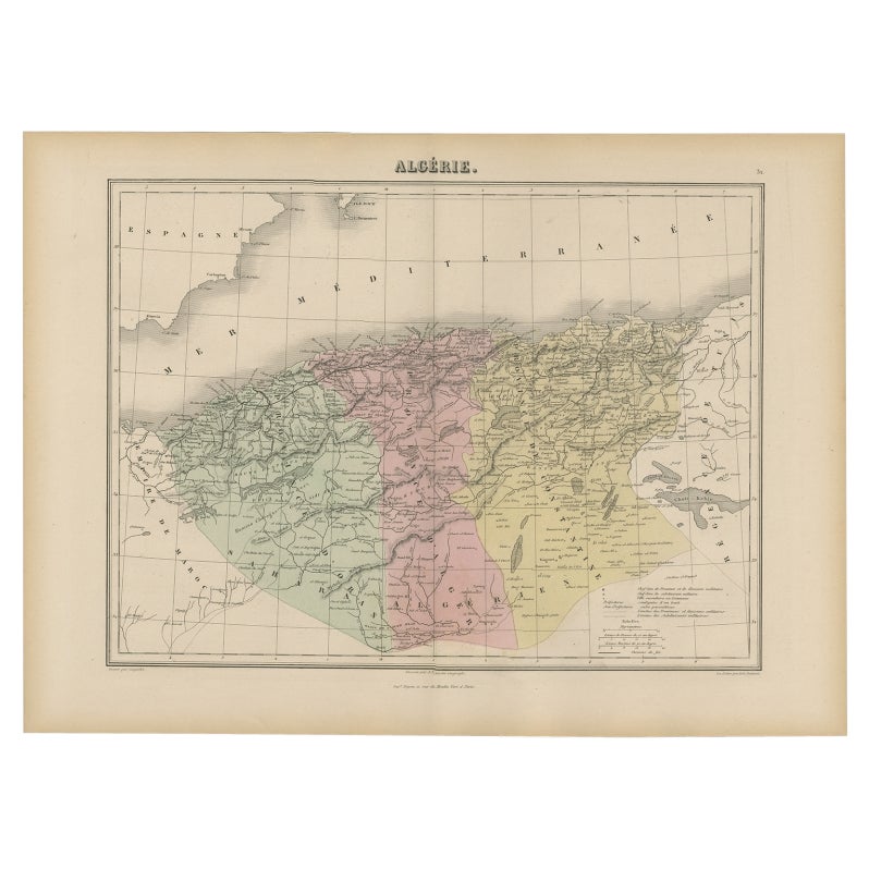
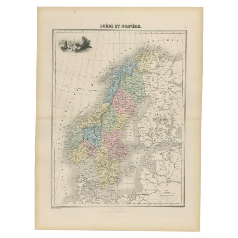
Antique Map of the Province of Oran Algeria by Migeon, 1880
View Similar Items
Want more images or videos?
Request additional images or videos from the seller
1 of 5
Antique Map of the Province of Oran Algeria by Migeon, 1880
About the Item
- Dimensions:Height: 13.59 in (34.5 cm)Width: 18.71 in (47.5 cm)Depth: 0 in (0.01 mm)
- Materials and Techniques:
- Period:
- Date of Manufacture:1880
- Condition:
- Seller Location:Langweer, NL
- Reference Number:Seller: BG-11793-371stDibs: LU3054327827702
About the Seller
5.0
Recognized Seller
These prestigious sellers are industry leaders and represent the highest echelon for item quality and design.
Platinum Seller
Premium sellers with a 4.7+ rating and 24-hour response times
Established in 2009
1stDibs seller since 2017
2,419 sales on 1stDibs
Authenticity Guarantee
In the unlikely event there’s an issue with an item’s authenticity, contact us within 1 year for a full refund. DetailsMoney-Back Guarantee
If your item is not as described, is damaged in transit, or does not arrive, contact us within 7 days for a full refund. Details24-Hour Cancellation
You have a 24-hour grace period in which to reconsider your purchase, with no questions asked.Vetted Professional Sellers
Our world-class sellers must adhere to strict standards for service and quality, maintaining the integrity of our listings.Price-Match Guarantee
If you find that a seller listed the same item for a lower price elsewhere, we’ll match it.Trusted Global Delivery
Our best-in-class carrier network provides specialized shipping options worldwide, including custom delivery.More From This Seller
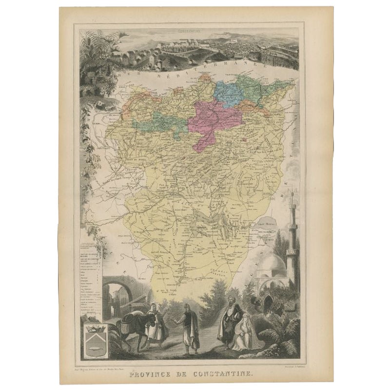
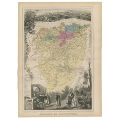
View AllAntique Map of the Province of Constantine, Algeria by Migeon, 1880
Located in Langweer, NL
Antique map titled 'Province de Constantine'. Old map of the province of Constantine, Algeria. The Department of Constantine existed from 1848 to 1962 and was one of the three admini...
Category
Antique 19th Century Maps
Materials
Paper
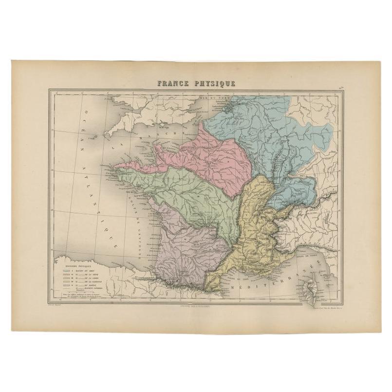
Antique Map of France by Migeon, 1880
Located in Langweer, NL
Antique map titled 'France Physique'. Old map of France. This map originates from 'Géographie Universelle Atlas-Migeon' by J. Migeon.
Artists and Engravers: Published by J. Migeon...
Category
Antique 19th Century Maps
Materials
Paper

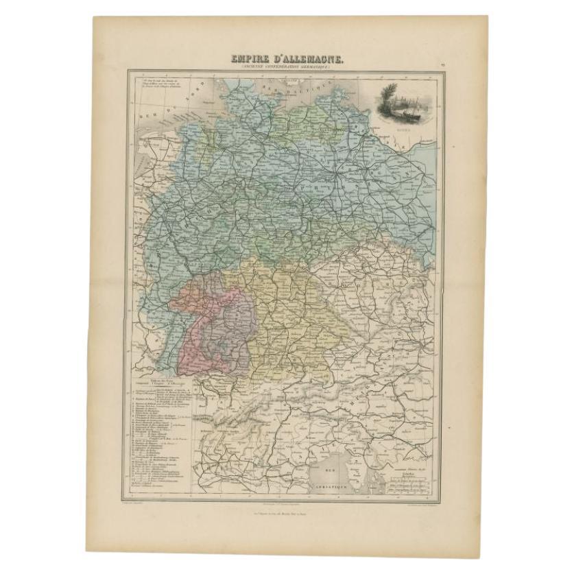
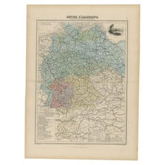
Antique Map of the German Empire by Migeon, 1880
Located in Langweer, NL
Antique map titled 'Empire d'Allemagne'. Old map of Germany. With decorative vignette of Mainz. This map originates from 'Géographie Universelle Atlas-Migeon' by J. Migeon.
Artist...
Category
Antique 19th Century Maps
Materials
Paper
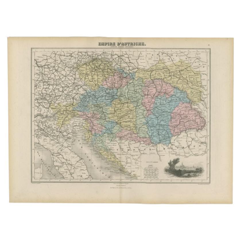
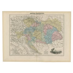
Antique Map of the Austrian Empire by Migeon, 1880
Located in Langweer, NL
Antique map titled 'Empire d'Autriche'. Old map of the Austrian Empire. With decorative vignette with a view of Vienna. This map originates from 'Géographie Universelle Atlas-Migeon'...
Category
Antique 19th Century Maps
Materials
Paper
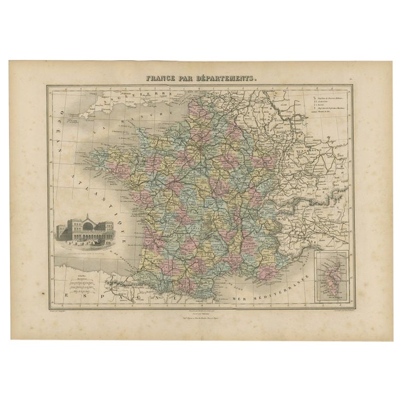
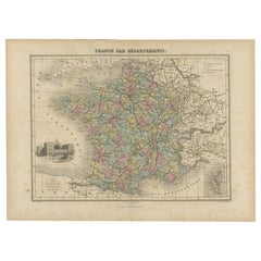
Antique Map of the Departments of France by Migeon, 1880
By J. Migeon
Located in Langweer, NL
Antique map titled 'France par Départements'. Old map of France with a decorative vignette of Strasbourg and an inset map of Corsica. This map originate...
Category
Antique 19th Century Maps
Materials
Paper
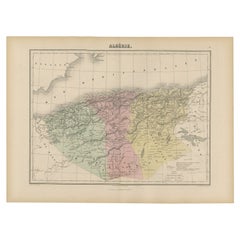
Antique Map of Algeria, 1880
Located in Langweer, NL
Antique map titled 'Algérie. Old map of Algeria. This map originates from 'Géographie Universelle Atlas-Migeon' by J. Migeon.
Artists and Engravers: Published by J. Migeon. Review...
Category
Antique 19th Century Maps
Materials
Paper
You May Also Like
Antique 18th Century Map of the Province of Pensilvania 'Pennsylvania State'
Located in Philadelphia, PA
A fine antique of the colony of Pennsylvania.
Noted at the top of the sheet as a 'Map of the province of Pensilvania'.
This undated and anonymous map is thought to be from the Gentleman's Magazine, London, circa 1775, although the general appearance could date it to the 1760's.
The southern boundary reflects the Mason-Dixon survey (1768), the western boundary is placed just west of Pittsburgh, and the northern boundary is not marked.
The map has a number of reference points that likely refer to companion text and appear to be connected to boundaries. The western and southern boundaries are marked Q, R, S, for example. A diagonal line runs from the Susquehanna R to the Lake Erie P. A broken line marked by many letters A, B, N, O, etc., appears in the east.
There are no latitude or longitude markings, blank verso.
Framed in a shaped contemporary gilt wooden frame and matted under a cream colored matte.
Bearing an old Graham Arader Gallery...
Category
Antique 18th Century British American Colonial Maps
Materials
Paper

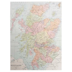
Original Antique Map of Scotland. Circa 1880
Located in St Annes, Lancashire
Great map of Scotland
Drawn and Engraved by J.Bartholomew
Published C.1880
Original colour
Unframed.
Category
Antique 1880s English Maps
Materials
Paper
Large Original Antique Map of the Environs of Cork, Ireland, circa 1880
Located in St Annes, Lancashire
Great map of The Environs of Cork
Published circa 1880
Unframed
Free shipping.
Category
Antique 1880s Scottish Maps
Materials
Paper

Large Original Antique Map of The Environs of Dublin, Ireland, circa 1880
Located in St Annes, Lancashire
Great map of The Environs of Dublin
Published circa 1880
Unframed
Free shipping.
Category
Antique 1880s Scottish Maps
Materials
Paper

Original Antique Map of The Philippines. C.1900
Located in St Annes, Lancashire
Fabulous map of The Philippines
Original color.
Engraved and printed by the George F. Cram Company, Indianapolis.
Published, C.1900.
Unframed.
Free shipping.
Category
Antique 1890s American Maps
Materials
Paper

Original Antique Map of The World by Thomas Clerk, 1817
Located in St Annes, Lancashire
Great map of The Eastern and Western Hemispheres
On 2 sheets
Copper-plate engraving
Drawn and engraved by Thomas Clerk, Edinburgh.
Published by Mackenzie And Dent, 1817
...
Category
Antique 1810s English Maps
Materials
Paper

Recently Viewed
View AllMore Ways To Browse
Hand Painted Bone China
High Gloss Desk
Indian Dining Chair
Industrial Steel Benches
Italian Red Leather And Chrome Chairs
Japanese Slab
Knight Helmet
Lacquer Dressing Table
Ladies Writing Tables
Lalique Red
Late 18th Century Cushions
Leather Bolster
Leather Tufted Ottoman
Leopard Motif
Lidded Glass Urns
Love From Afar
Luxury Sofa Pillow
Mahogany Bar Trolley