Items Similar to Antique Map of the Province Groningen in The Netherlands, c.1680


Want more images or videos?
Request additional images or videos from the seller
1 of 6
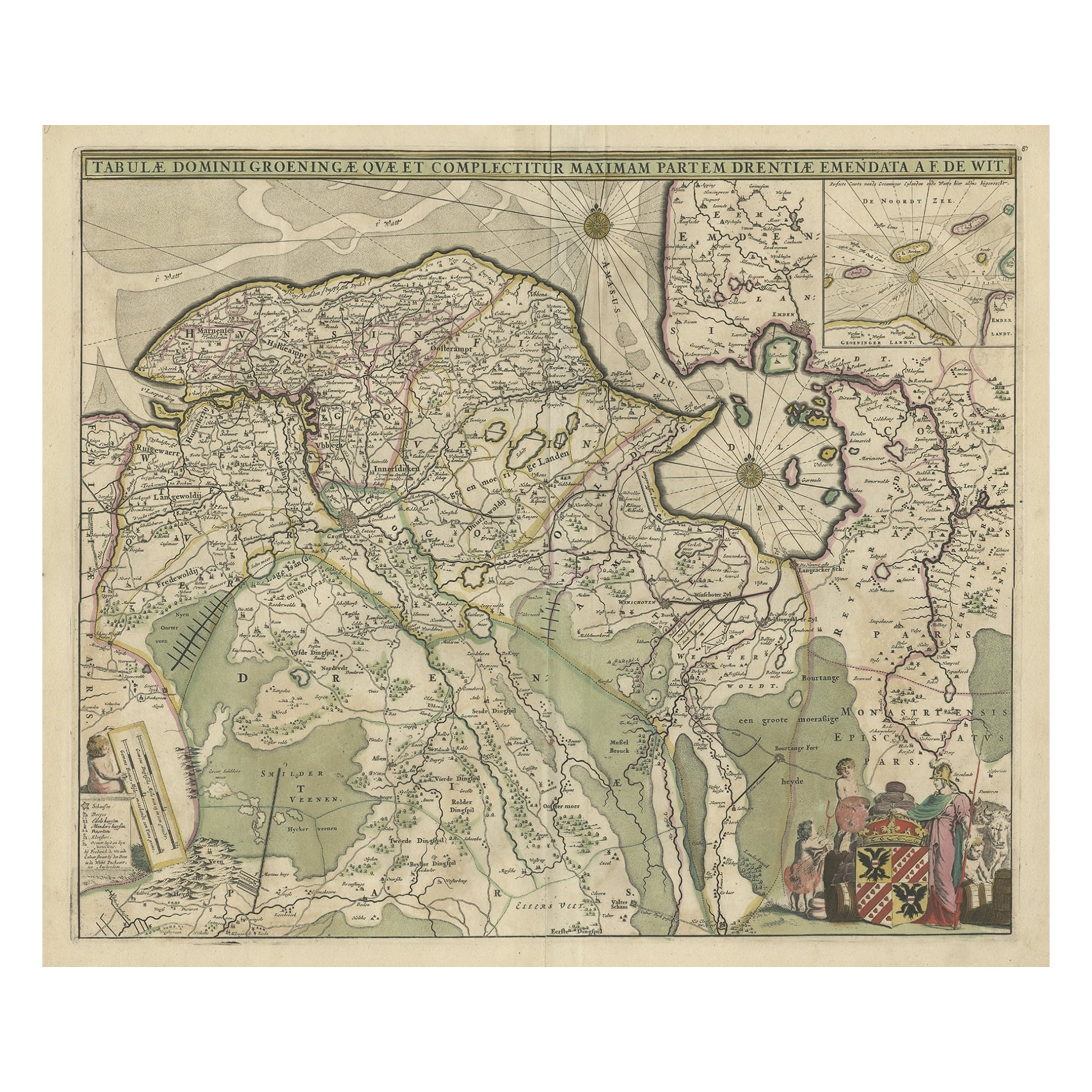
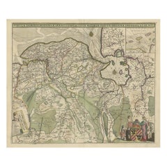
Antique Map of the Province Groningen in The Netherlands, c.1680
About the Item
Antique map titled 'Groningae et Omlandiae Dominium vulgo de Provincie van Stadt en Lande'.
Old map of the province of Groningen, the Netherlands. This map originates from 'Germania Inferior (..)'.
Artists and Engravers: The Visscher family were art and map dealers in Amsterdam during the 17th century. Funded by C. J. Visscher (1587-1652), the business was continued by his son and grandson both named Nicolaes. Nicolaes Visscher I was born 1618 in Wenns, Austria. He died 1679 in Linz. Nicolaes Visscher II (Amsterdam; 1649-1702). After the death of Nicolas II, his widow passed the business to Pieter Schenk.
Artist: The Visscher family were art and map dealers in Amsterdam during the 17th century. Funded by C. J. Visscher (1587-1652), the business was continued by his son and grandson both named Nicolaes. Nicolaes Visscher I was born 1618 in Wenns, Austria. He died 1679 in Linz. Nicolaes Visscher II (Amsterdam; 1649-1702). After the death of Nicolas II, his widow passed the business to Pieter Schenk.
Condition: Fair, general age-related toning. Original/contemporary hand coloring. Some creasing and repair on folding line and tears. Partly strengthened with tape on verso, please study image carefully.
Date: c.1680
Overall size: 62.5 x 52 cm.
Image size: 56 x 46 cm.
We sell original antique maps to collectors, historians, educators and interior decorators all over the world. Our collection includes a wide range of authentic antique maps from the 16th to the 20th centuries. Buying and collecting antique maps is a tradition that goes back hundreds of years. Antique maps have proved a richly rewarding investment over the past decade, thanks to a growing appreciation of their unique historical appeal. Today the decorative qualities of antique maps are widely recognized by interior designers who appreciate their beauty and design flexibility. Depending on the individual map, presentation, and context, a rare or antique map can be modern, traditional, abstract, figurative, serious or whimsical. We offer a wide range of authentic antique maps for any budget.
- Dimensions:Height: 20.48 in (52 cm)Width: 24.61 in (62.5 cm)Depth: 0 in (0.01 mm)
- Materials and Techniques:
- Period:
- Date of Manufacture:circa 1680
- Condition:Condition: Fair, general age-related toning. Original/contemporary hand coloring. Some creasing and repair on folding line and tears. Partly strengthened with tape on verso, please study image carefully.
- Seller Location:Langweer, NL
- Reference Number:Seller: BG-11879-21stDibs: LU3054326360152
About the Seller
5.0
Recognized Seller
These prestigious sellers are industry leaders and represent the highest echelon for item quality and design.
Platinum Seller
Premium sellers with a 4.7+ rating and 24-hour response times
Established in 2009
1stDibs seller since 2017
2,412 sales on 1stDibs
Typical response time: 1 hour
- ShippingRetrieving quote...Shipping from: Langweer, Netherlands
- Return Policy
Authenticity Guarantee
In the unlikely event there’s an issue with an item’s authenticity, contact us within 1 year for a full refund. DetailsMoney-Back Guarantee
If your item is not as described, is damaged in transit, or does not arrive, contact us within 7 days for a full refund. Details24-Hour Cancellation
You have a 24-hour grace period in which to reconsider your purchase, with no questions asked.Vetted Professional Sellers
Our world-class sellers must adhere to strict standards for service and quality, maintaining the integrity of our listings.Price-Match Guarantee
If you find that a seller listed the same item for a lower price elsewhere, we’ll match it.Trusted Global Delivery
Our best-in-class carrier network provides specialized shipping options worldwide, including custom delivery.More From This Seller
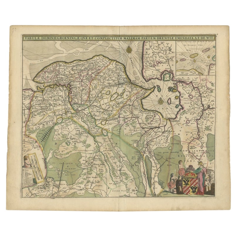
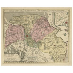
View AllOld Map of the Province of Groningen, the Netherlands & inset of Islands, C.1680
Located in Langweer, NL
Antique map titled 'Tabulae dominii Groeningae quae et complecitur maximam partem Drentiae Emendata'.
Old map of the province of Groningen, the Netherlands. With an inset map of ...
Category
Antique 1680s Maps
Materials
Paper
$1,160 Sale Price
20% Off
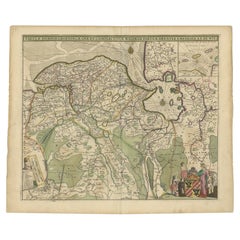
Antique Map of the Province of Groningen in the Netherlands, c.1700
Located in Langweer, NL
Antique map titled 'Groningae et Omlandiae Dominium vulgo de Provincie van Stadt en Lande'.
Old map of the province of Groningen, the Netherlands. This map originates from 'Atlas C...
Category
Antique 18th Century Maps
Materials
Paper
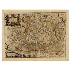
Antique Map of The Dutch Province of Groningen by De Wit, c.1680
Located in Langweer, NL
Antique map titled 'Tabulae dominii Groeningae quae et complecitur maximam partem Drentiae Emendata'.
Old map of the province of Groningen, the Netherlands. With an inset map of th...
Category
Antique 17th Century Maps
Materials
Paper
Antique Map of the Province of Overijssel, the Netherlands
Located in Langweer, NL
Original antique map titled 'Ditio Trans-Isulana'. Original old map of the province of Overijssel, the Netherlands. With coat of arms and two decorative cartouches. Published by J. J...
Category
Antique Mid-17th Century Maps
Materials
Paper

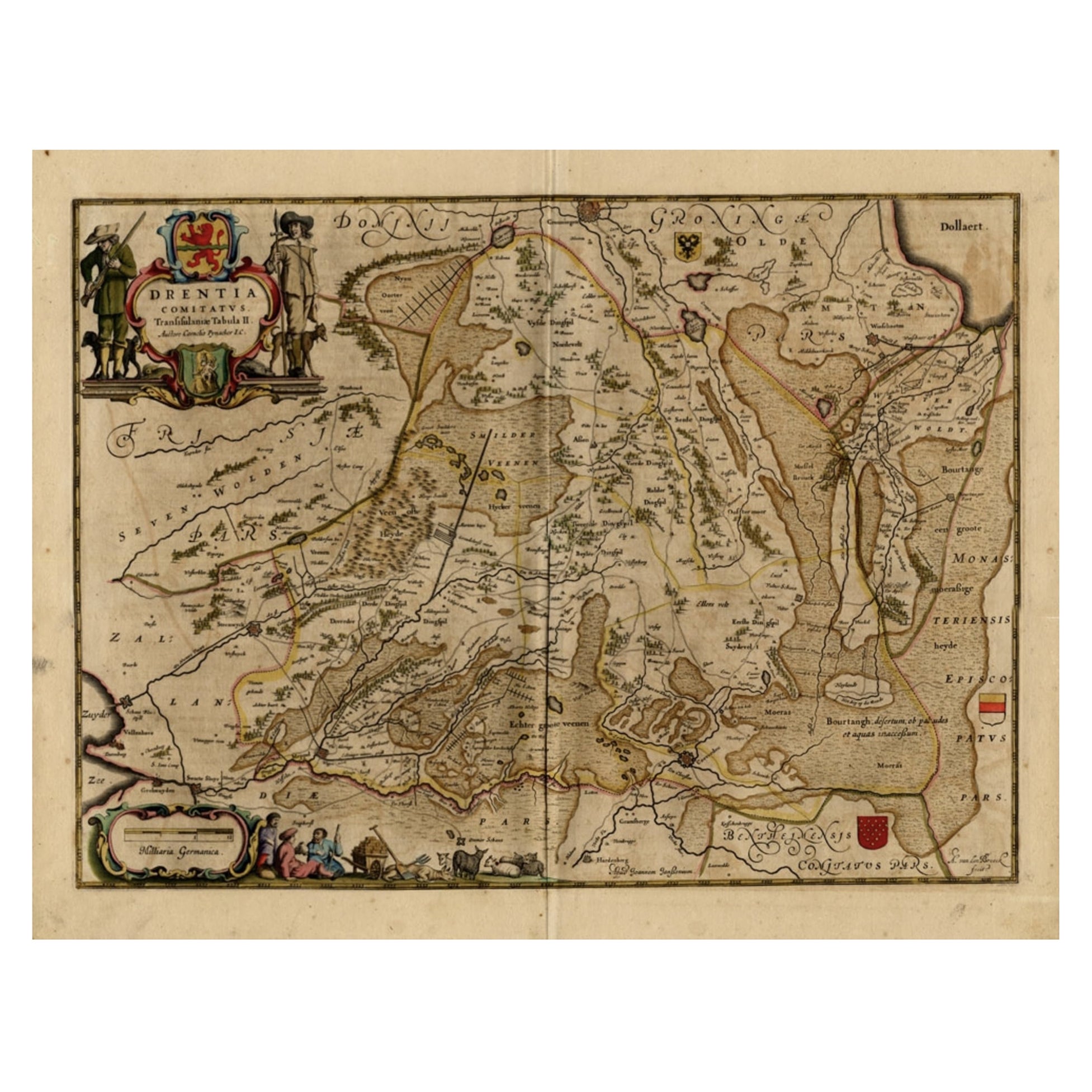
Antique Map of Drenthe, a Province in The Netherlands, 1658
Located in Langweer, NL
Antique map titled 'Drentia comitatus (..)'. Copper engraved contemp. hand coloured map of Drenthe, a province in the Netherlands. Large cartouche with coats of arms. This map is mad...
Category
Antique 17th Century Maps
Materials
Paper
$603 Sale Price
20% Off
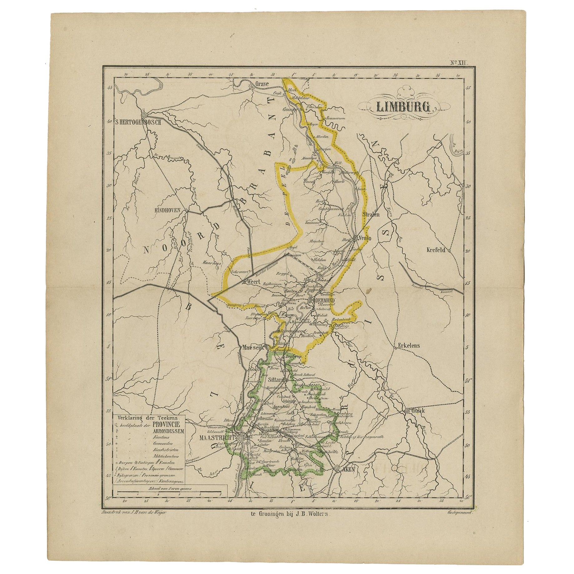
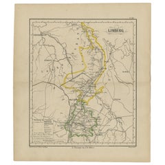
Antique Map of the Province Limburg, The Netherlands, 1864
Located in Langweer, NL
Antique map titled 'De Provincie Limburg'. Map of the province of Limburg, the Netherlands. This map originates from 'F. C. Brugsma's Atlas van het Koninkrijk der Nederlanden (..)'. ...
Category
Antique 19th Century Maps
Materials
Paper
You May Also Like
Antique 18th Century Map of the Province of Pensilvania 'Pennsylvania State'
Located in Philadelphia, PA
A fine antique of the colony of Pennsylvania.
Noted at the top of the sheet as a 'Map of the province of Pensilvania'.
This undated and anonymous map is thought to be from the Gentleman's Magazine, London, circa 1775, although the general appearance could date it to the 1760's.
The southern boundary reflects the Mason-Dixon survey (1768), the western boundary is placed just west of Pittsburgh, and the northern boundary is not marked.
The map has a number of reference points that likely refer to companion text and appear to be connected to boundaries. The western and southern boundaries are marked Q, R, S, for example. A diagonal line runs from the Susquehanna R to the Lake Erie P. A broken line marked by many letters A, B, N, O, etc., appears in the east.
There are no latitude or longitude markings, blank verso.
Framed in a shaped contemporary gilt wooden frame and matted under a cream colored matte.
Bearing an old Graham Arader Gallery...
Category
Antique 18th Century British American Colonial Maps
Materials
Paper

Map of the Republic of Genoa
Located in New York, NY
Framed antique hand-coloured map of the Republic of Genoa including the duchies of Mantua, Modena, and Parma.
Europe, late 18th century.
Dimension: 25...
Category
Antique Late 18th Century European Maps

Antique Map of Principality of Monaco
By Antonio Vallardi Editore
Located in Alessandria, Piemonte
ST/619 - "Old Geographical Atlas of Italy - Topographic map of ex-Principality of Monaco" -
ediz Vallardi - Milano -
A somewhat special edition ---
Category
Antique Late 19th Century Italian Other Prints
Materials
Paper

Original Antique Map of The World by Thomas Clerk, 1817
Located in St Annes, Lancashire
Great map of The Eastern and Western Hemispheres
On 2 sheets
Copper-plate engraving
Drawn and engraved by Thomas Clerk, Edinburgh.
Published by Mackenzie And Dent, 1817
...
Category
Antique 1810s English Maps
Materials
Paper

Map "Estuary- Mouth of the Thames"
Located in Alessandria, Piemonte
ST/426 - Antique French Map of the estuary of the Thames, map dated 1769 -
"Mape of the entrance of the Thames. Designed by filing of Navy cards fo...
Category
Antique Mid-18th Century French Other Prints
Materials
Paper

Original Antique Map of China, Arrowsmith, 1820
Located in St Annes, Lancashire
Great map of China
Drawn under the direction of Arrowsmith
Copper-plate engraving
Published by Longman, Hurst, Rees, Orme and Brown, 1820
Unfr...
Category
Antique 1820s English Maps
Materials
Paper

Recently Viewed
View AllMore Ways To Browse
Dior Size 46
Modular Sofa Cassina
Organic Cotton Sofa
Ottoman Sale
Outdoor Furniture Metal Bench
Outdoor Metal Bench
Oval Serving Bowl
Pair Of Antique Stools
Pair Three Drawer Tables
Peacock Carpet
Philippe Starck Black Tables
Professional Plaques
Raw Stone Side Table
Reed And Barton Serving Fork
Reed And Barton Serving Spoon
Reed Barton Silver Serving Fork
Regency Bar Italian Made
Rococo Trim