Items Similar to Antique Map of the Mouth of the Amu Darya River by Reclus, 1881

Want more images or videos?
Request additional images or videos from the seller
1 of 5
Antique Map of the Mouth of the Amu Darya River by Reclus, 1881
About the Item
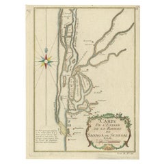
Antique map titled 'Bouches de L'Amou - Daria'. Original antique map showing the river mouth of the Amu Darya river in Central Asia. This original old antique print / plate originates from: 'Nouvelle Geographie Universelle La Terre et les Hommes VI : L' Asie Russe' by Jacques Elisee Reclus. published in Paris by Hachette & Cie.. 1881.
Artists and Engravers: Jacques Elisee Reclus was a renowned French geographer. writer and anarchist. He produced his 19-volume masterwork La Nouvelle Geographie universelle. la terre et les hommes ('Universal Geography'). over a period of nearly 20 years (1875 � 1894).
Condition: Good. General age related toning and soiling. Please study image carefully.
Date: 1881
Overall size: 34.5 x 26.5 cm.
Image size: 29 x 22.5 cm.
We sell original antique maps to collectors, historians, educators and interior decorators all over the world. Our collection includes a wide range of authentic antique maps from the 16th to the 20th centuries. Buying and collecting antique maps is a tradition that goes back hundreds of years. Antique maps have proved a richly rewarding investment over the past decade, thanks to a growing appreciation of their unique historical appeal. Today the decorative qualities of antique maps are widely recognized by interior designers who appreciate their beauty and design flexibility. Depending on the individual map, presentation, and context, a rare or antique map can be modern, traditional, abstract, figurative, serious or whimsical. We offer a wide range of authentic antique maps for any budget
- Dimensions:Height: 10.44 in (26.5 cm)Width: 13.59 in (34.5 cm)Depth: 0 in (0.01 mm)
- Materials and Techniques:
- Period:
- Date of Manufacture:1881
- Condition:Condition: Good. General age related toning and soiling. Please study image carefully.
- Seller Location:Langweer, NL
- Reference Number:Seller: PCT-280831stDibs: LU3054327835022
About the Seller
5.0
Recognized Seller
These prestigious sellers are industry leaders and represent the highest echelon for item quality and design.
Platinum Seller
Premium sellers with a 4.7+ rating and 24-hour response times
Established in 2009
1stDibs seller since 2017
2,415 sales on 1stDibs
Typical response time: 1 hour
- ShippingRetrieving quote...Shipping from: Langweer, Netherlands
- Return Policy
Authenticity Guarantee
In the unlikely event there’s an issue with an item’s authenticity, contact us within 1 year for a full refund. DetailsMoney-Back Guarantee
If your item is not as described, is damaged in transit, or does not arrive, contact us within 7 days for a full refund. Details24-Hour Cancellation
You have a 24-hour grace period in which to reconsider your purchase, with no questions asked.Vetted Professional Sellers
Our world-class sellers must adhere to strict standards for service and quality, maintaining the integrity of our listings.Price-Match Guarantee
If you find that a seller listed the same item for a lower price elsewhere, we’ll match it.Trusted Global Delivery
Our best-in-class carrier network provides specialized shipping options worldwide, including custom delivery.More From This Seller
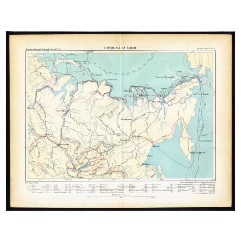
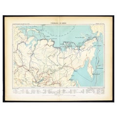
View AllAntique Map of Siberia by Reclus, 1881
Located in Langweer, NL
Antique map titled 'Itineraires en Siberie.' This map shows the itineraries of famous explorers in Siberia between 1648 and 1879. This original old antique print / plate originates f...
Category
Antique 19th Century Maps
Materials
Paper
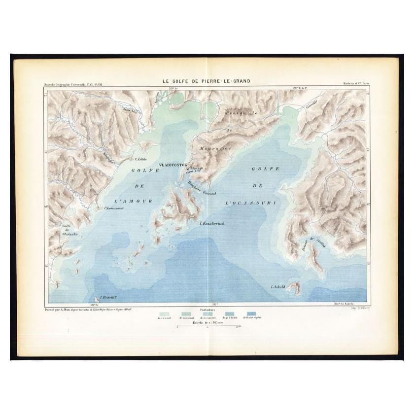
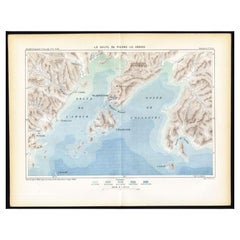
Antique Map of the Peter the Great Gulf by Reclus, 1881
Located in Langweer, NL
Antique map titled 'Le Golfe de Pierre-Le-Grand.' This map shows the Peter The Great Gulf in the Sea of Japan adjoining the coast of Russia's Primorski...
Category
Antique 19th Century Maps
Materials
Paper
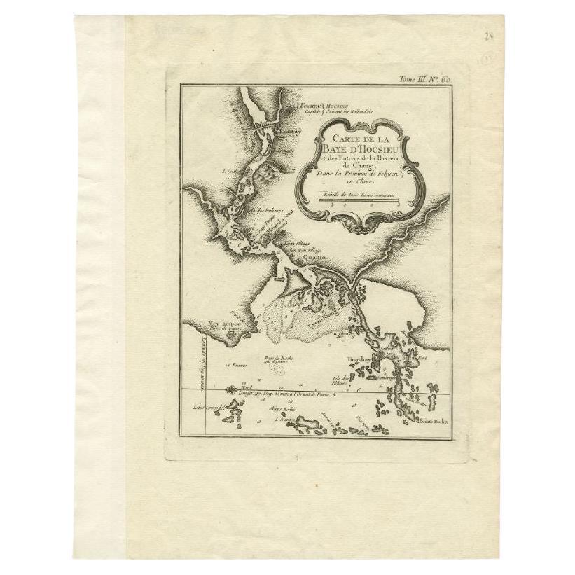
Antique Map of the Mouth of the Chiang River by Bellin, 1764
By Jacques-Nicolas Bellin
Located in Langweer, NL
Antique map titled ‘Carte de la Baye d'Hocsieu et des Entrees de la Riviere de Chang, Dans la Province de Fokyen en Chine’. This impressive map or sea chart d...
Category
Antique 18th Century Maps
Materials
Paper

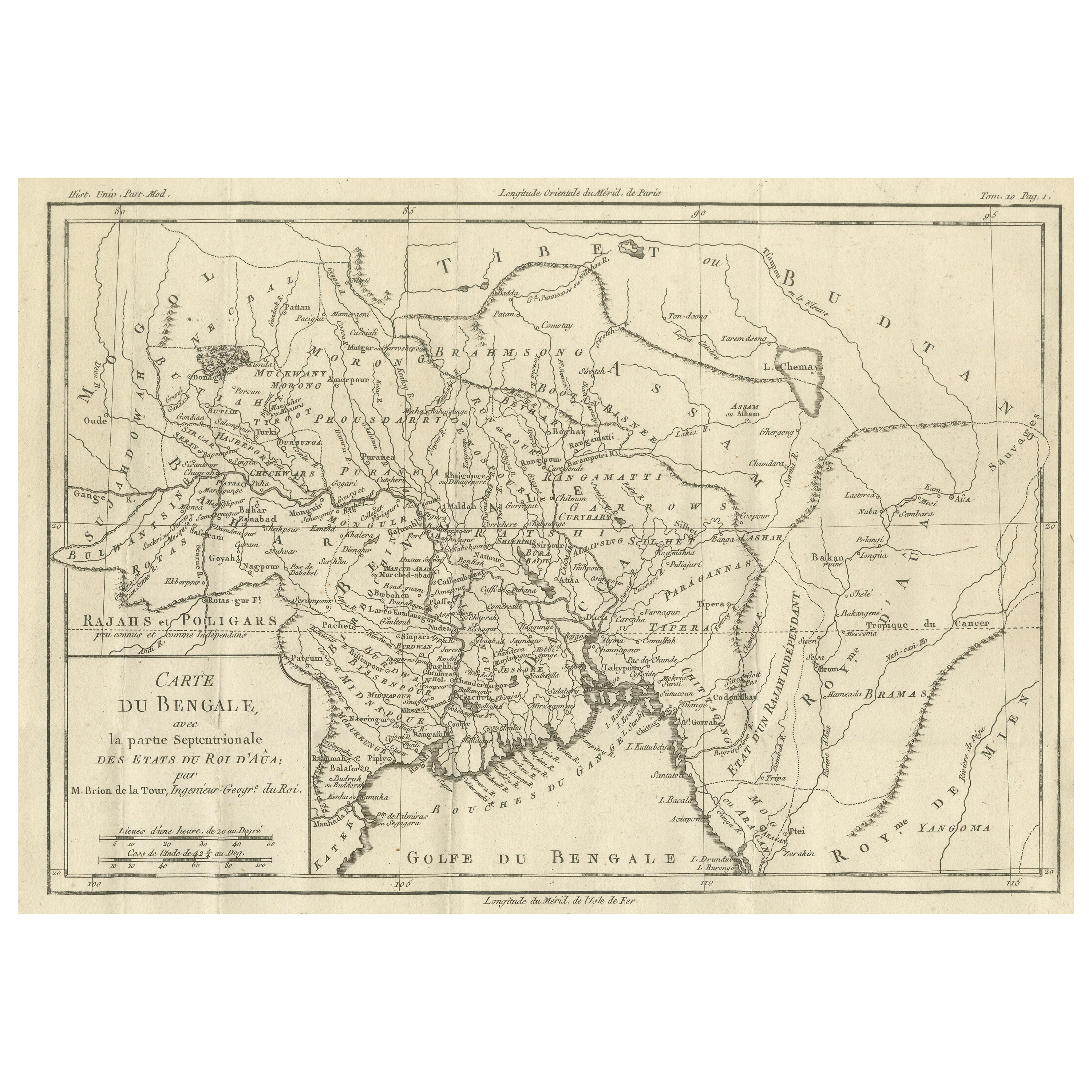
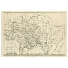
Antique Map of of Bengal and the mouth of the Ganges River
Located in Langweer, NL
Antique map titled 'Carte du Bengale, avec la partie Septentrionale (..)'. Original antique map of Bengal and the mouth of the Ganges river. This map ori...
Category
Antique Late 18th Century Maps
Materials
Paper
Antique Map of the Mouth of the Yangtze River 'China' by J.N. Bellin, 1764
Located in Langweer, NL
This detailed regional map of China is a historical cartographic work from the mid-18th century and is attributed to Antoine-François Prévost, a prominent French cartographer and geo...
Category
Antique Mid-18th Century Maps
Materials
Paper

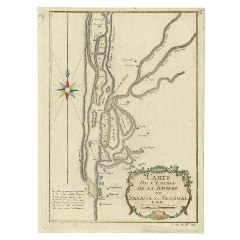
Antique Map of The Senegal River by Bellin, 1746
Located in Langweer, NL
Antique map titled 'Carte de l'Entrée de la Rivière de Sanaga ou Senegal'. Map of the mouth of the Senegal River. This map originates from Prevost's 'Histoire Generale des Voyages'. ...
Category
Antique 18th Century Maps
Materials
Paper
You May Also Like
Map "Estuary- Mouth of the Thames"
Located in Alessandria, Piemonte
ST/426 - Antique French Map of the estuary of the Thames, map dated 1769 -
"Mape of the entrance of the Thames. Designed by filing of Navy cards fo...
Category
Antique Mid-18th Century French Other Prints
Materials
Paper

Antique Oarsman's Map of the River Thames, English, Cartography, Published 1912
Located in Hele, Devon, GB
This is an antique copy of The Oarsman's and Angler's Map of the River Thames - New Edition. An English, bound map book, published in English by Edward Stanford, London, this new edi...
Category
Early 20th Century British Other Books
Materials
Paper

Original Antique Map of The Philippines. C.1900
Located in St Annes, Lancashire
Fabulous map of The Philippines
Original color.
Engraved and printed by the George F. Cram Company, Indianapolis.
Published, C.1900.
Unframed.
Free shipping.
Category
Antique 1890s American Maps
Materials
Paper

Original Antique Map of The World by Thomas Clerk, 1817
Located in St Annes, Lancashire
Great map of The Eastern and Western Hemispheres
On 2 sheets
Copper-plate engraving
Drawn and engraved by Thomas Clerk, Edinburgh.
Published by Mackenzie And Dent, 1817
...
Category
Antique 1810s English Maps
Materials
Paper

Large Original Antique Map of The Bahamas. 1894
Located in St Annes, Lancashire
Superb Antique map of The Bahamas
Published Edward Stanford, Charing Cross, London 1894
Original colour
Good condition
Unframed.
Free shipping
Category
Antique 1890s English Maps
Materials
Paper

Large Original Antique Map of the The Windward Islands. 1894
Located in St Annes, Lancashire
Superb Antique map of The Windward Islands
Published Edward Stanford, Charing Cross, London 1894
Original colour
Good condition
Unframed.
Free shipping
Category
Antique 1890s English Maps
Materials
Paper

Recently Viewed
View AllMore Ways To Browse
Sunbrella Chair
Tapestry Uzbekistan
Tea Table With Inlay
Throw Pillows Botanical
Tiled Round Table
Tomlinson Furniture Vintage
Triangular End Table
Unusual Ottoman
Upholstered Sofa With Chaise
Used Hitchcock Furniture
Velvet Brass Sofa Mid Century
Venetian Armchair
Vietnam Coffee Table
Vintage Brutalist Console
Vintage Cognac Glasses
Vintage Glass Peacock
Vintage Italian Dressing Table
Vintage Tuareg Rug