Items Similar to Antique Map of the Middle East by Perthes, 1848

Want more images or videos?
Request additional images or videos from the seller
1 of 5
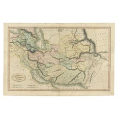
Antique Map of the Middle East by Perthes, 1848
About the Item
Antique map titled 'Terra inter Euphratem et Indum Antiqua'. Old map of the Middle East originating from 'Orbis Terrarum Antiquus in usum Scholarum'.
Artists and Engravers: Published by Justus Perthes, 1848.
Condition: Good, general age-related toning. Minor defects, please study image carefully.
Date: 1848
Overall size: 31.8 x 24.8 cm.
Image size: 24.3 x 17.8 cm.
We sell original antique maps to collectors, historians, educators and interior decorators all over the world. Our collection includes a wide range of authentic antique maps from the 16th to the 20th centuries. Buying and collecting antique maps is a tradition that goes back hundreds of years. Antique maps have proved a richly rewarding investment over the past decade, thanks to a growing appreciation of their unique historical appeal. Today the decorative qualities of antique maps are widely recognized by interior designers who appreciate their beauty and design flexibility. Depending on the individual map, presentation, and context, a rare or antique map can be modern, traditional, abstract, figurative, serious or whimsical. We offer a wide range of authentic antique maps for any budget
- Dimensions:Height: 9.77 in (24.8 cm)Width: 12.52 in (31.8 cm)Depth: 0 in (0.01 mm)
- Materials and Techniques:
- Period:
- Date of Manufacture:1848
- Condition:
- Seller Location:Langweer, NL
- Reference Number:Seller: BG-11845-131stDibs: LU3054327830352
About the Seller
5.0
Recognized Seller
These prestigious sellers are industry leaders and represent the highest echelon for item quality and design.
Platinum Seller
Premium sellers with a 4.7+ rating and 24-hour response times
Established in 2009
1stDibs seller since 2017
2,419 sales on 1stDibs
Typical response time: <1 hour
- ShippingRetrieving quote...Shipping from: Langweer, Netherlands
- Return Policy
Authenticity Guarantee
In the unlikely event there’s an issue with an item’s authenticity, contact us within 1 year for a full refund. DetailsMoney-Back Guarantee
If your item is not as described, is damaged in transit, or does not arrive, contact us within 7 days for a full refund. Details24-Hour Cancellation
You have a 24-hour grace period in which to reconsider your purchase, with no questions asked.Vetted Professional Sellers
Our world-class sellers must adhere to strict standards for service and quality, maintaining the integrity of our listings.Price-Match Guarantee
If you find that a seller listed the same item for a lower price elsewhere, we’ll match it.Trusted Global Delivery
Our best-in-class carrier network provides specialized shipping options worldwide, including custom delivery.More From This Seller
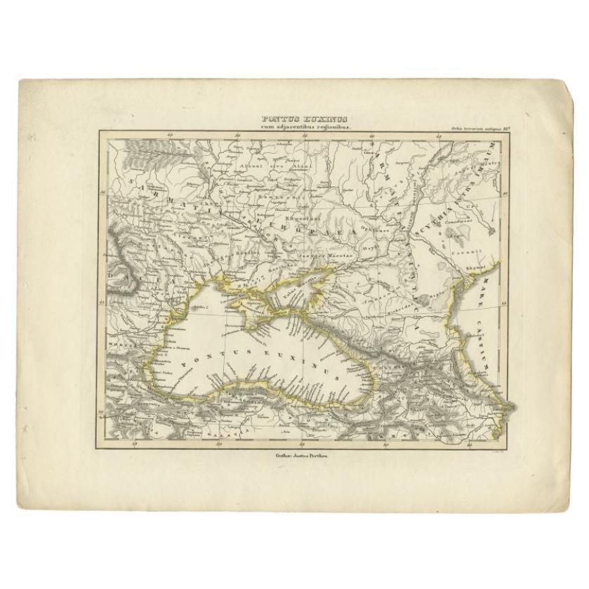
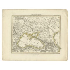
View AllAntique Map of the Black Sea by Perthes, 1848
Located in Langweer, NL
Antique map titled 'Pontus Euxinus'. Old map of the Black Sea and surroundings originating from 'Orbis Terrarum Antiquus in usum Scholarum'. Artists and Engravers: Published by Justu...
Category
Antique 19th Century Maps
Materials
Paper
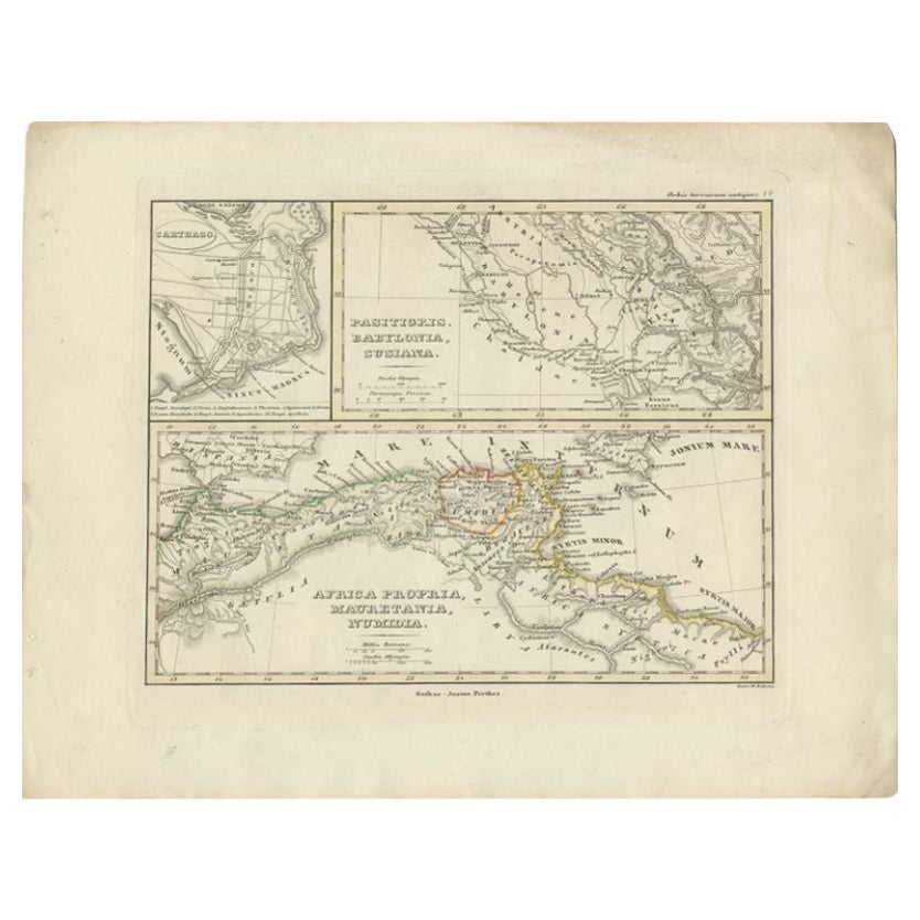
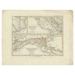
Antique Map of Northern Africa by Perthes, 1848
Located in Langweer, NL
Antique map titled 'Africa Propria (..)'. Old map of North Africa and the region of Babylon originating from 'Orbis Terrarum Antiquus in usum Scholarum'. Artists and Engravers: Publi...
Category
Antique 19th Century Maps
Materials
Paper
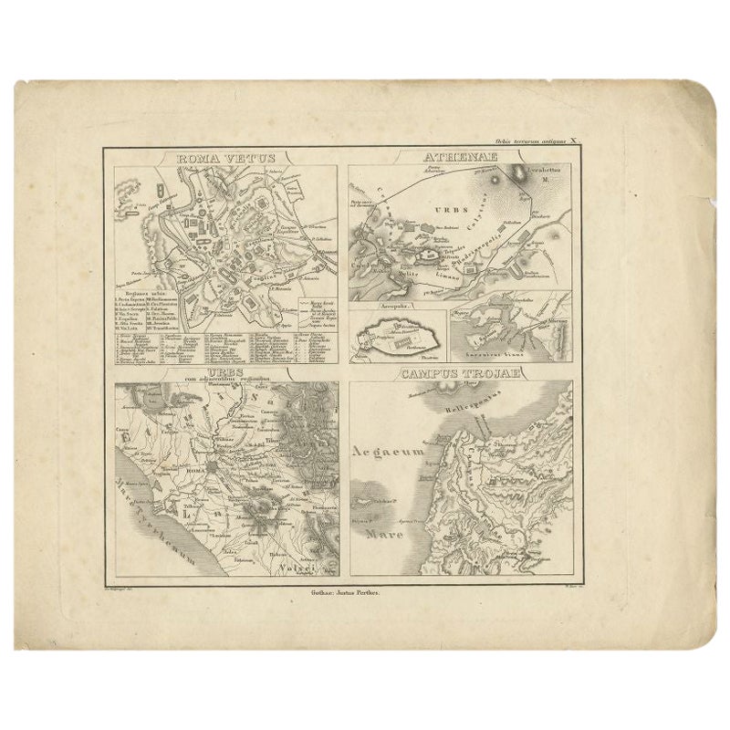
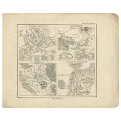
Antique Map of Rome and Athens by Perthes, 1848
Located in Langweer, NL
Antique map titled 'Roma Vetus, Athenae, Urbs, Campus Trojae'. Old map of Rome, Athens and surroundings originating from 'Orbis Terrarum Antiquus in usum S...
Category
Antique 19th Century Maps
Materials
Paper
Antique Map of the Middle East by Mortier, 1700
Located in Langweer, NL
Antique map titled 'Carte de la Situation du Paradis Terrestre (..)'. Detailed map of the Holy Land and the Middle East, centered on the Garden of Eden and including a large Cyprus. ...
Category
Antique 18th Century Maps
Materials
Paper

$223 Sale Price
20% Off
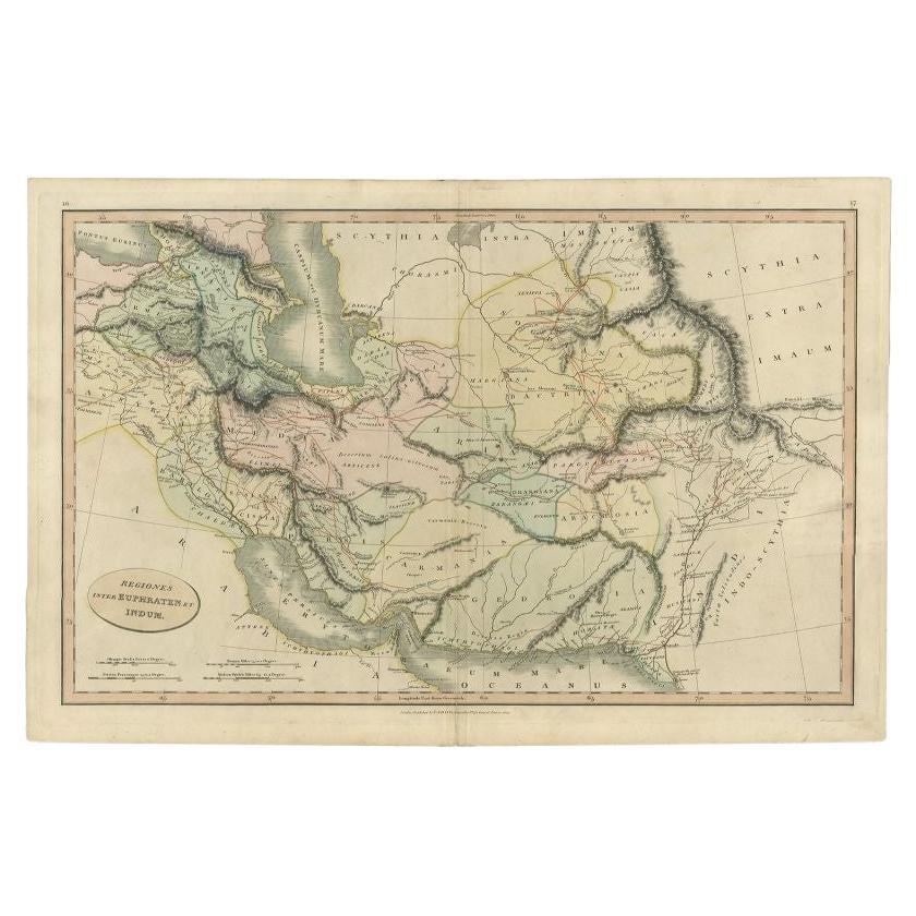
Antique Map of the Middle East by Smith, 1809
Located in Langweer, NL
Antique map titled 'Regiones inter Euphraten et Indum'. Old map of the Middle East showing the region between the Euphrates and Indus river. Ori...
Category
Antique 19th Century Maps
Materials
Paper
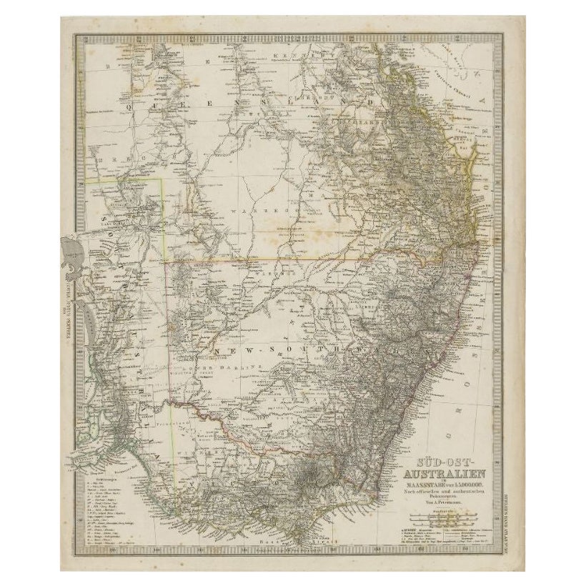
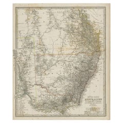
Antique Map of South East Australia by Stieler, c.1848
By Thomas Kitchin
Located in Langweer, NL
Antique map Australia titled 'Süd-Ost Australien'. Detailed map of South East Australia. Orginates from 'Stieler's Hand Atlas', published in Germ...
Category
Antique 19th Century Maps
Materials
Paper
You May Also Like
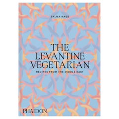
The Levantine Vegetarian Recipes from the Middle East
Located in New York, NY
Vibrant vegetarian home-cooking recipes, capturing the essence of the Middle East, from the award-winning author of the best-selling The Lebanese Kitchen
This glorious celebration of a bold vegetarian cuisine features 140 easy-to-make, bright, uplifting plant-based recipes, including classics such as falafels, hummus, and tabbouleh, as well as unique dishes reflective of region, religion, and culture across the Levant.
The food is fresh and delicious, whether it’s garlic-laced mezze dishes, pittas stuffed with pickles, tahini, and grilled vegetables, or sweet and spicy desserts. Covering a vast area straddling Africa, Asia, and the gateway to Europe, the book embraces the culinary traditions of all corners of the Cradle of Civilization.
Hage, one of the world’s authorities on Middle Eastern...
Category
2010s Chinese Books
Materials
Paper
East German Map
By VEB Hermann Haack
Located in Baltimore, MD
A brilliantly colourful map of the Leipzig, Karl Marx Stadt and Dresden area in the former German Democratic Republic by VEB Hermann Haack of Gotha.
Category
Vintage 1970s German Maps

$295 Sale Price
25% Off
Original Antique Map of South East Asia by Thomas Clerk, 1817
Located in St Annes, Lancashire
Great map of South East Asia
Copper-plate engraving
Drawn and engraved by Thomas Clerk, Edinburgh.
Published by Mackenzie And Dent, 1817
Unframed.
Category
Antique 1810s English Maps
Materials
Paper

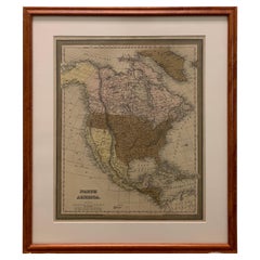
Large 1848 North America & Territories Map
Located in Stamford, CT
Framed 1848 S. Augustus and Mitchell, Philadelphia , PA North America and territories map.
Featuring the United States, Canada (British Territory) and Mexican Territories.
As found...
Category
Antique 1840s American American Classical Maps
Materials
Glass, Wood, Paper
London 1744 Published Watercolour Antique Map of East Africa by Eman Bowen
Located in West Sussex, Pulborough
We are delighted to offer for sale this New and Accurate Map of Nubia & Abissinia, together with all the Kingdoms Tributary Thereto, and bordering upon them published in 1744 by Emanuel Bowen
This is a decorative antique engraved map of East Africa...
Category
Antique 1740s English George III Maps
Materials
Paper

$1,039 Sale Price
20% Off
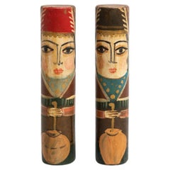
Set of Two Antique Middle East Hand-Painted Wooden Stick Figures, circa 1960
Located in Barcelona, ES
Set of two hand-painted antique figures of two men made of wood. Explore the captivating charm of these two hand-painted antique wooden stick fig...
Category
Vintage 1960s Turkish Mid-Century Modern Toys and Dolls
Materials
Wood
Recently Viewed
View AllMore Ways To Browse
Maison Jansen Steel And Brass Table
Maison Jansen Table Chrome Brass
Male Trophy
Maple Arm Chairs
Marcel Breuer Cane
Mid Century Salt And Pepper Shaker
Midcentury Latin American Design
Midcentury Outdoor Side Table
Milo 18
Milo Baughman Burl Table
Model 91
Modern George Armchairs
Mother Of Pearl Inlay Table Top
Needlepoint Upholstery
Ottoman White With Table
Pair Vintage Leather Swivel Chairs
Paul Evans Brutalist Table
Petal Chairs