Items Similar to Antique Map of Mayenne ‘France’ by V. Levasseur, 1854


Want more images or videos?
Request additional images or videos from the seller
1 of 5
Antique Map of Mayenne ‘France’ by V. Levasseur, 1854
About the Item
Antique map titled 'Dépt. de la Mayenne'. Map of the French department of Mayenne, France. This area is part of the Loire Valley wine region. The map is surrounded by elaborate decorative engravings designed to illustrate both the natural beauty and trade richness of the land. There is a short textual history of the regions depicted on both the left and right sides of the map. This map originates from ‘Atlas National de la France Illustré’. Published by A. Combette, Paris, 1854.
- Dimensions:Height: 13.98 in (35.5 cm)Width: 20.67 in (52.5 cm)Depth: 0.02 in (0.5 mm)
- Materials and Techniques:
- Period:
- Date of Manufacture:1854
- Condition:General age-related toning. Please study image carefully.
- Seller Location:Langweer, NL
- Reference Number:Seller: BG-05614/771stDibs: LU3054310764811
About the Seller
5.0
Recognized Seller
These prestigious sellers are industry leaders and represent the highest echelon for item quality and design.
Platinum Seller
Premium sellers with a 4.7+ rating and 24-hour response times
Established in 2009
1stDibs seller since 2017
2,415 sales on 1stDibs
Typical response time: 1 hour
- ShippingRetrieving quote...Shipping from: Langweer, Netherlands
- Return Policy
Authenticity Guarantee
In the unlikely event there’s an issue with an item’s authenticity, contact us within 1 year for a full refund. DetailsMoney-Back Guarantee
If your item is not as described, is damaged in transit, or does not arrive, contact us within 7 days for a full refund. Details24-Hour Cancellation
You have a 24-hour grace period in which to reconsider your purchase, with no questions asked.Vetted Professional Sellers
Our world-class sellers must adhere to strict standards for service and quality, maintaining the integrity of our listings.Price-Match Guarantee
If you find that a seller listed the same item for a lower price elsewhere, we’ll match it.Trusted Global Delivery
Our best-in-class carrier network provides specialized shipping options worldwide, including custom delivery.More From This Seller
View AllAntique Map of Jura ‘France’ by V. Levasseur, 1854
By Victor Levasseur
Located in Langweer, NL
Antique map titled 'Dépt. du Jura'. Map of the French department Jura, France. The Jura wines are very distinctive and unusual, such as Vin Jaune, which is made by a similar process ...
Category
Antique Mid-19th Century Maps
Materials
Paper

Antique Map of Loire ‘France’ by V. Levasseur, 1854
Located in Langweer, NL
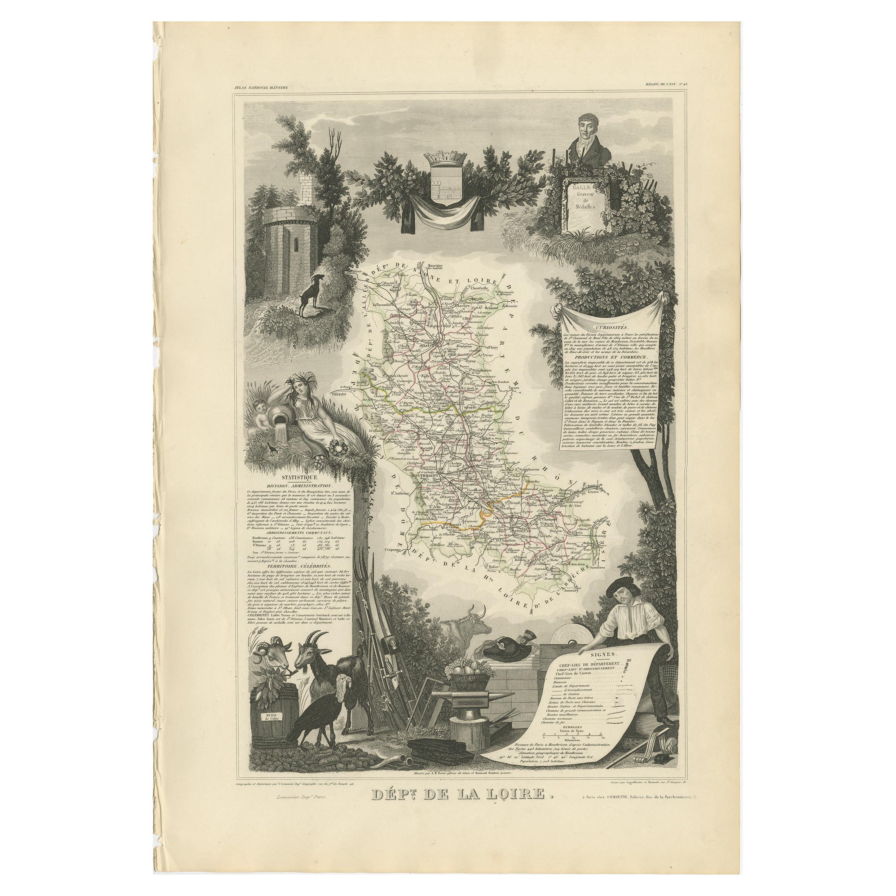
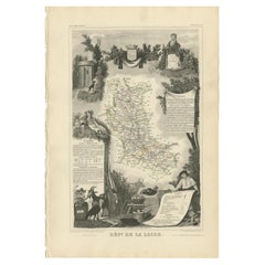
Antique map titled 'Dépt. de la Loire'. Map of the French department of Loire, France. This area of France is part of the Loire Valley wine growing region...
Category
Antique Mid-19th Century Maps
Materials
Paper
Antique Map of Eure ‘France’ by V. Levasseur, 1854
By Victor Levasseur
Located in Langweer, NL
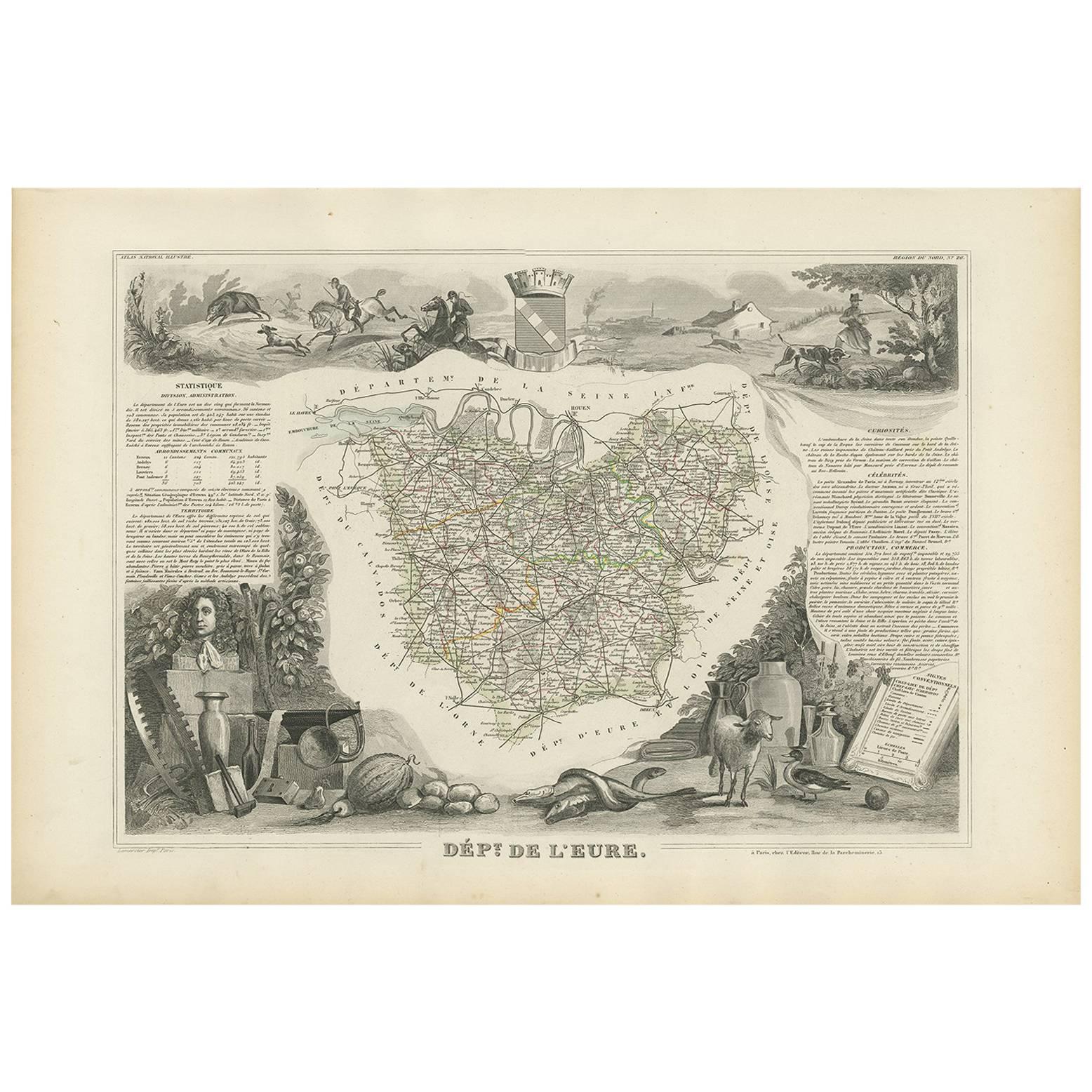
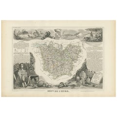
Antique map titled 'Dépt. de l'Eure'. Map of the French department of Eure, France. This region of France is home to Giverny, where impressionist Claude Monet’s home and garden can b...
Category
Antique Mid-19th Century Maps
Materials
Paper
$166 Sale Price
20% Off
Antique Map of Hérault ‘France’ by V. Levasseur, 1854
Located in Langweer, NL
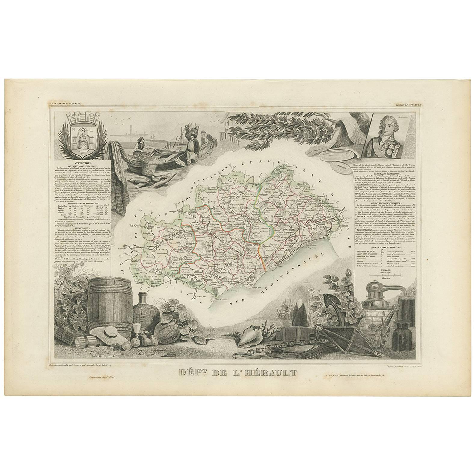
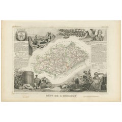
Antique map titled 'Dépt. de l'Hérault'. Map of the French department of Herault, France. This area is home to a wide variety of vineyards and is part of the larger Languedoc wine-gr...
Category
Antique Mid-19th Century Maps
Materials
Paper
$166 Sale Price
20% Off
Antique Map of Landes ‘France’ by V. Levasseur, 1854
By Victor Levasseur
Located in Langweer, NL
Antique map titled 'Dépt. des Landes'. Map of the French department Landes, France. This area is known for its production of Chalossais, a white cow cheese with a gentle, acidic edge...
Category
Antique Mid-19th Century Maps
Materials
Paper

$166 Sale Price
20% Off
Antique Map of Vienne 'France' by V. Levasseur, 1854
By Victor Levasseur
Located in Langweer, NL
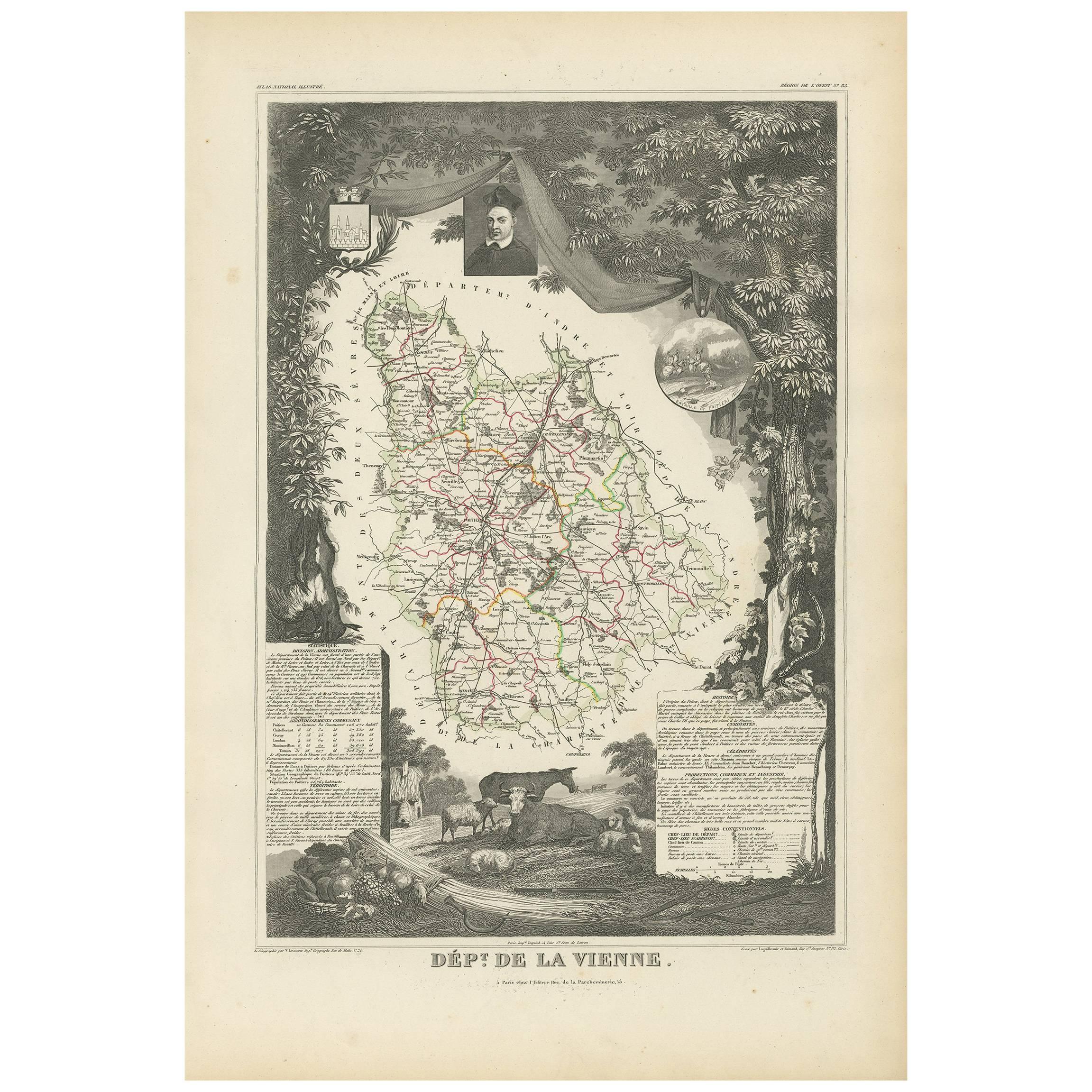
Antique map titled 'Dépt. de la Vienne'. Decorative antique map of the French Department of Vienne, with its capital of Poitiers and small engraved vignette of the battle of Poitiers...
Category
Antique Mid-19th Century Maps
Materials
Paper

$166 Sale Price
20% Off
You May Also Like
Antique Map of Italy by Andriveau-Goujon, 1843
By Andriveau-Goujon
Located in New York, NY
Antique Map of Italy by Andriveau-Goujon, 1843. Map of Italy in two parts by Andriveau-Goujon for the Library of Prince Carini at Palazzo Carini i...
Category
Antique 1840s French Maps
Materials
Linen, Paper

$3,350 / set
Antique Map of Principality of Monaco
By Antonio Vallardi Editore
Located in Alessandria, Piemonte
ST/619 - "Old Geographical Atlas of Italy - Topographic map of ex-Principality of Monaco" -
ediz Vallardi - Milano -
A somewhat special edition ---
Category
Antique Late 19th Century Italian Other Prints
Materials
Paper

Original Antique Map of Sweden, Engraved by Barlow, 1806
Located in St Annes, Lancashire
Great map of Sweden
Copper-plate engraving by Barlow
Published by Brightly & Kinnersly, Bungay, Suffolk. 1806
Unframed.
Category
Antique Early 1800s English Maps
Materials
Paper

Original Antique Map of Switzerland, Engraved By Barlow, Dated 1807
Located in St Annes, Lancashire
Great map of Switzerland
Copper-plate engraving by Barlow
Published by Brightly & Kinnersly, Bungay, Suffolk.
Dated 1807
Unframed.
Category
Antique Early 1800s English Maps
Materials
Paper

Original Antique Map of The World by Thomas Clerk, 1817
Located in St Annes, Lancashire
Great map of The Eastern and Western Hemispheres
On 2 sheets
Copper-plate engraving
Drawn and engraved by Thomas Clerk, Edinburgh.
Published by Mackenzie And Dent, 1817
...
Category
Antique 1810s English Maps
Materials
Paper

Original Antique Map of Europe, Arrowsmith, 1820
Located in St Annes, Lancashire
Great map of Europe
Drawn under the direction of Arrowsmith.
Copper-plate engraving.
Published by Longman, Hurst, Rees, Orme and Brown, 1820
...
Category
Antique 1820s English Maps
Materials
Paper

Recently Viewed
View AllMore Ways To Browse
World Map Copper
Old School Maps
Scottish Fold
Map Of Vienna
Antique Map Mexico
Malaysian Antique Furniture
Map Of Middle East
Antique Map Of Switzerland
Birds Eye View Map
Pacific Ocean Antique Map
Topographical Plate
Antique Maps California
Antique Portuguese Plates
Joan Blaeu
Blaeu World Map
Cornelius And Company
Cornelius Company
Map Of Arabia