Items Similar to Antique Map of the Jiangxi Province of China by Du Halde, 1738


Want more images or videos?
Request additional images or videos from the seller
1 of 5
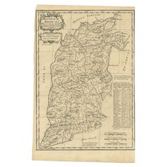
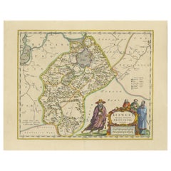
Antique Map of the Jiangxi Province of China by Du Halde, 1738
About the Item
Antique map titled 'Province III Kyang-Si'. Old map depicting the Jiangxi province of China. Originates from 'A description of the Empire of China and Chinese-Tartary' by J.B. du Halde. Du Halde's work inspired great interest in China among Europeans, and was a ground breaking work in geography.
Artists and Engravers: Published by E. Cave, London.
Condition: Good, age-related toning. Few marginal defects and worm holes (slightly affecting image), please study image carefully.
Date: 1738
Overall size: 30 x 39 cm.
Image size: 27 x 33.5 cm.
We sell original antique maps to collectors, historians, educators and interior decorators all over the world. Our collection includes a wide range of authentic antique maps from the 16th to the 20th centuries. Buying and collecting antique maps is a tradition that goes back hundreds of years. Antique maps have proved a richly rewarding investment over the past decade, thanks to a growing appreciation of their unique historical appeal. Today the decorative qualities of antique maps are widely recognized by interior designers who appreciate their beauty and design flexibility. Depending on the individual map, presentation, and context, a rare or antique map can be modern, traditional, abstract, figurative, serious or whimsical. We offer a wide range of authentic antique maps for any budget.
- Dimensions:Height: 15.36 in (39 cm)Width: 11.82 in (30 cm)Depth: 0 in (0.01 mm)
- Materials and Techniques:
- Period:
- Date of Manufacture:1738
- Condition:
- Seller Location:Langweer, NL
- Reference Number:Seller: BGJC-1681stDibs: LU3054327826872
About the Seller
5.0
Recognized Seller
These prestigious sellers are industry leaders and represent the highest echelon for item quality and design.
Platinum Seller
Premium sellers with a 4.7+ rating and 24-hour response times
Established in 2009
1stDibs seller since 2017
2,419 sales on 1stDibs
Typical response time: <1 hour
- ShippingRetrieving quote...Shipping from: Langweer, Netherlands
- Return Policy
Authenticity Guarantee
In the unlikely event there’s an issue with an item’s authenticity, contact us within 1 year for a full refund. DetailsMoney-Back Guarantee
If your item is not as described, is damaged in transit, or does not arrive, contact us within 7 days for a full refund. Details24-Hour Cancellation
You have a 24-hour grace period in which to reconsider your purchase, with no questions asked.Vetted Professional Sellers
Our world-class sellers must adhere to strict standards for service and quality, maintaining the integrity of our listings.Price-Match Guarantee
If you find that a seller listed the same item for a lower price elsewhere, we’ll match it.Trusted Global Delivery
Our best-in-class carrier network provides specialized shipping options worldwide, including custom delivery.More From This Seller
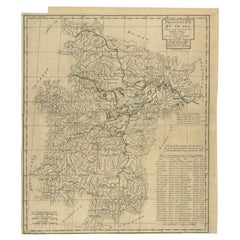
View AllAntique Map of the Shanxi Province of China by Du Halde, 1738
Located in Langweer, NL
Antique map titled 'Province IX Shan-Si'. Old map depicting the Shanxi province of China. Originates from 'A description of the Empire of China and Chinese-Tartary' by J.B. du Halde....
Category
Antique 18th Century Maps
Materials
Paper
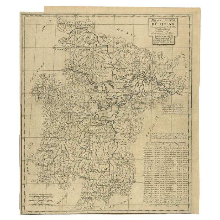
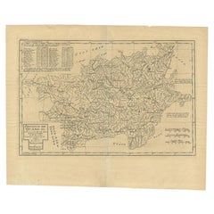
Antique Map of the Huguang Province of China by Du Halde, 1738
Located in Langweer, NL
Antique map titled 'Province VI Hu-Quang'. Old map depicting the Huguang province of China. Originates from 'A description of the Empire of China and Chinese-Tartary' by by J.B. du H...
Category
Antique 18th Century Maps
Materials
Paper
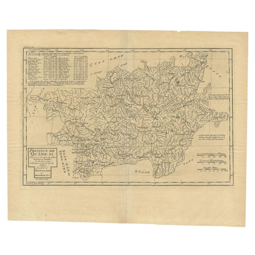
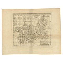
Antique Map of the Province of Quang-Si by Du Halde, 1738
Located in Langweer, NL
Antique map titled 'Province XIII Quang-Si. Drawn on the spot by ye Peres de Tartre & Cordoso in the year 1714'. Old map of the Chinese province Quang-Si. Originates from the Edward ...
Category
Antique 18th Century Maps
Materials
Paper
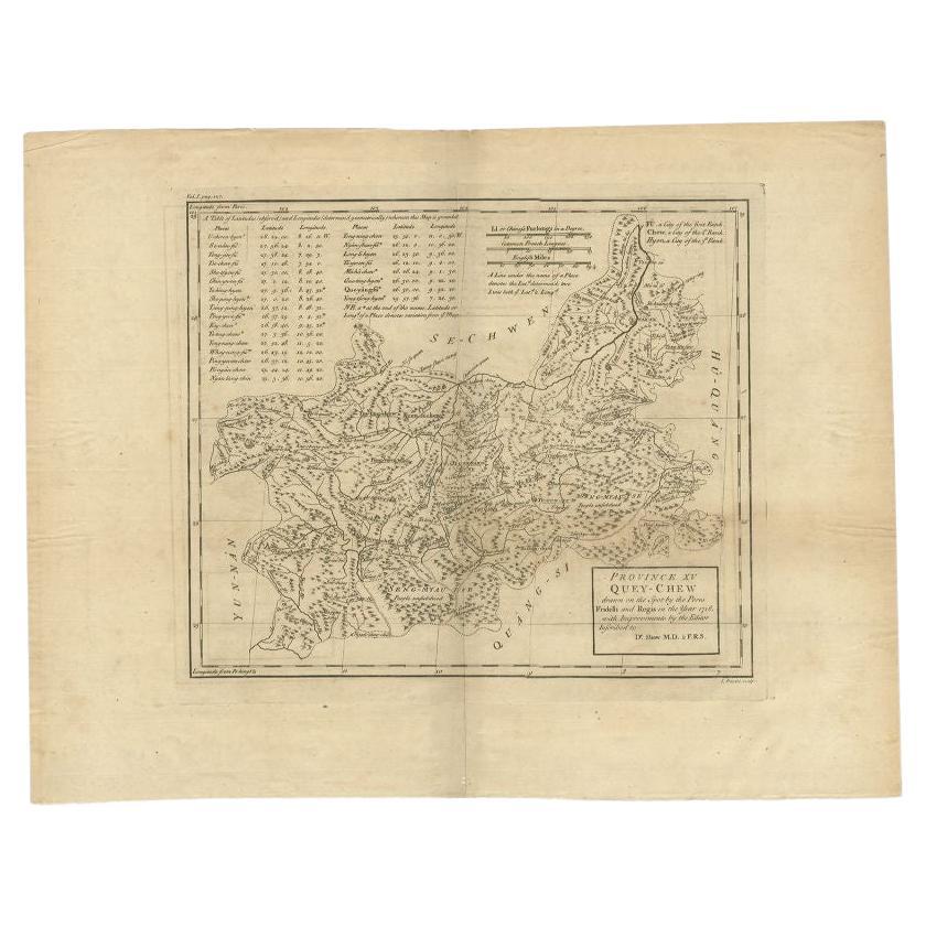
Antique Map of the Province of Quey-Chew by Du Halde, 1738
Located in Langweer, NL
Antique map titled 'Province XV Quey-Chew drawn on the spot by the Peres Fridelli and Regis in the year 1716'. Old map of the Chinese province Quey-Chew. Originates from the Edward C...
Category
Antique 18th Century Maps
Materials
Paper
17th-Century Antique Map of Jiangxi (Kiangsi) Province, China – by Blaeu
Located in Langweer, NL
Title: 17th-Century Antique Map of Jiangxi Province, China – "Kiangsi" by Blaeu, Detailed and Vibrantly Colored
Description: This detailed 17th-century map of Jiangxi Province, historically referred to as "Kiangsi," was created by Johannes Blaeu and published in 1655 as part of the *Novus Atlas Sinensis*. Jiangxi, located in southeastern China, is known for its cultural heritage, scenic landscapes, and significant contributions to Chinese history.
The map meticulously charts Jiangxi’s geography, including mountain ranges, rivers, and cities, with place names rendered in Latin. Poyang Lake, one of the largest freshwater lakes in China, is prominently depicted, emphasizing the region’s ecological and economic importance. The map also highlights key cities such as Nanchang, the provincial capital, which has long been a cultural and political center, and Jingdezhen, globally famous as the center of Chinese porcelain production.
The decorative cartouche in the lower-right corner features traditional Chinese figures, adding cultural depth to the map. Blaeu’s craftsmanship is evident in the precise copperplate engraving and the vibrant hand-coloring, which enhances the boundaries and natural features, making this map both a functional document and a work of art.
Condition: Nearly excellent. Sharp impression with vivid hand-coloring. Wide margins with minor age-toning appropriate for its age.
Framing Tips: Use a neutral double mat and an ornate gilt or dark wood frame to highlight the map’s historical and artistic value. UV-protective glass is recommended to preserve the hand-coloring and intricate details.
Jiangxi, historically referred to as "Kiangsi," is famous for its rich cultural history, stunning landscapes, and economic contributions. It has been a key region for porcelain production, with Jingdezhen renowned as the "Porcelain Capital" of the world. Poyang Lake, featured prominently on the map, is vital for fishing, transportation, and its ecological significance. The province’s location along the Gan River has historically made it an important transportation corridor. Nanchang, the provincial capital, is noted for its historical landmarks and political significance in modern Chinese history.
Keywords include: antique map of Jiangxi, Kiangsi map, Poyang Lake, Jingdezhen porcelain, 17th-century China map...
Category
Antique 1650s Maps
Materials
Paper
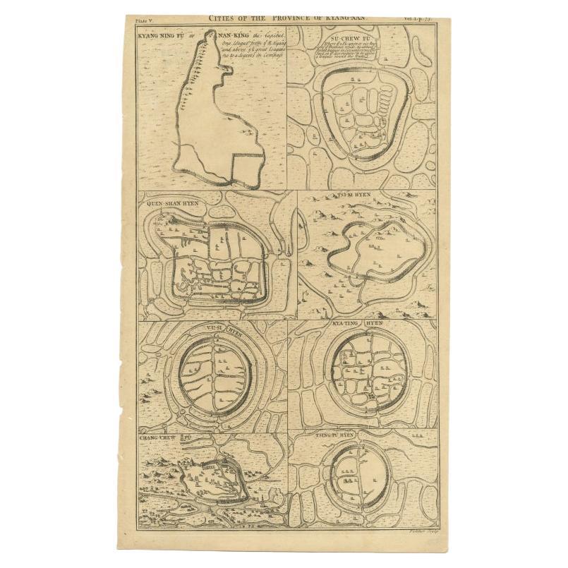
Antique Map of Cities of the Province of Che-Kiang in China, 1738
Located in Langweer, NL
Antique map titled 'Cities of the Province of Che-Kyang'. Old map depicting four walled cities of the Chinese Qing dynasty province of Che-Kiang (modern day CHEKIANG): Hang Chew Fu (...
Category
Antique 18th Century Maps
Materials
Paper
You May Also Like
Antique 18th Century Map of the Province of Pensilvania 'Pennsylvania State'
Located in Philadelphia, PA
A fine antique of the colony of Pennsylvania.
Noted at the top of the sheet as a 'Map of the province of Pensilvania'.
This undated and anonymous map is thought to be from the Gentleman's Magazine, London, circa 1775, although the general appearance could date it to the 1760's.
The southern boundary reflects the Mason-Dixon survey (1768), the western boundary is placed just west of Pittsburgh, and the northern boundary is not marked.
The map has a number of reference points that likely refer to companion text and appear to be connected to boundaries. The western and southern boundaries are marked Q, R, S, for example. A diagonal line runs from the Susquehanna R to the Lake Erie P. A broken line marked by many letters A, B, N, O, etc., appears in the east.
There are no latitude or longitude markings, blank verso.
Framed in a shaped contemporary gilt wooden frame and matted under a cream colored matte.
Bearing an old Graham Arader Gallery...
Category
Antique 18th Century British American Colonial Maps
Materials
Paper

Original Antique Map of China, Arrowsmith, 1820
Located in St Annes, Lancashire
Great map of China
Drawn under the direction of Arrowsmith
Copper-plate engraving
Published by Longman, Hurst, Rees, Orme and Brown, 1820
Unfr...
Category
Antique 1820s English Maps
Materials
Paper

Framed Map of China
Located in Greenwich, CT
Map of China, 19th century. European print map of China
Conservation frame with walnut frame
Overall dimension : 28 1/2" wide 31" high 2" depth with fra...
Category
Antique 19th Century European Qing Prints
Materials
Paper

$3,800
Super Rare Antique French Map of Chine and the Chinese Empire, 1780
Located in Amsterdam, Noord Holland
Super Rare Antique French Map of Chine and the Chinese Empire, 1780
Very nice map of Asia. 1780 Made by Bonne.
Additional information:
Type: Map
...
Category
Antique 18th Century European Maps
Materials
Paper

$584 Sale Price
31% Off
Original Antique Map of The Philippines. C.1900
Located in St Annes, Lancashire
Fabulous map of The Philippines
Original color.
Engraved and printed by the George F. Cram Company, Indianapolis.
Published, C.1900.
Unframed.
Free shipping.
Category
Antique 1890s American Maps
Materials
Paper

Original Antique Map of The World by Thomas Clerk, 1817
Located in St Annes, Lancashire
Great map of The Eastern and Western Hemispheres
On 2 sheets
Copper-plate engraving
Drawn and engraved by Thomas Clerk, Edinburgh.
Published by Mackenzie And Dent, 1817
...
Category
Antique 1810s English Maps
Materials
Paper

Recently Viewed
View AllMore Ways To Browse
Hand Painted Bone China
High Gloss Desk
Indian Dining Chair
Industrial Steel Benches
Italian Red Leather And Chrome Chairs
Japanese Slab
Knight Helmet
Lacquer Dressing Table
Ladies Writing Tables
Lalique Red
Late 18th Century Cushions
Leather Bolster
Leather Tufted Ottoman
Leopard Motif
Lidded Glass Urns
Love From Afar
Luxury Sofa Pillow
Mahogany Bar Trolley