Items Similar to Antique Map of the Dutch Gold Coast in Africa by Van den Bosch '1818'

Want more images or videos?
Request additional images or videos from the seller
1 of 5
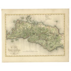
Antique Map of the Dutch Gold Coast in Africa by Van den Bosch '1818'
About the Item
Antique map titled 'Kaart van de Goud-Kust of Kust van Guina'. A rare and attractive early 19th century Dutch map of the Dutch Gold Coast. The Dutch Gold Coast or Dutch Guinea, was a portion of contemporary Ghana that was gradually colonized by the Dutch, beginning in 1598. The colony became the most important Dutch colony in West Africa after Fort Elmina was captured from the Portuguese in 1637, but fell into disarray after the abolition of the slave trade in the early 19th century. On 6 April 1872, the Dutch Gold Coast was, in accordance with the Anglo-Dutch Treaties of 1870–71, ceremonially ceded to the United Kingdom.
One of 12 maps from 'Atlas van Overzeesche bezittingen' (Atlas of Oversea Possessions) by J.S. van den Bosch. J.S. van den Bosch (1780 – 1844), Major General, Knight of the 3rd Class of the Military William Order.
- Dimensions:Height: 18.12 in (46 cm)Width: 22.84 in (58 cm)Depth: 0.02 in (0.5 mm)
- Materials and Techniques:
- Period:
- Date of Manufacture:1818
- Condition:Wear consistent with age and use. General age-related toning. Some wear and marginal tears. Please study images carefully.
- Seller Location:Langweer, NL
- Reference Number:Seller: BG-061471stDibs: LU3054316542372
About the Seller
5.0
Recognized Seller
These prestigious sellers are industry leaders and represent the highest echelon for item quality and design.
Platinum Seller
Premium sellers with a 4.7+ rating and 24-hour response times
Established in 2009
1stDibs seller since 2017
2,412 sales on 1stDibs
Typical response time: 1 hour
- ShippingRetrieving quote...Shipping from: Langweer, Netherlands
- Return Policy
Authenticity Guarantee
In the unlikely event there’s an issue with an item’s authenticity, contact us within 1 year for a full refund. DetailsMoney-Back Guarantee
If your item is not as described, is damaged in transit, or does not arrive, contact us within 7 days for a full refund. Details24-Hour Cancellation
You have a 24-hour grace period in which to reconsider your purchase, with no questions asked.Vetted Professional Sellers
Our world-class sellers must adhere to strict standards for service and quality, maintaining the integrity of our listings.Price-Match Guarantee
If you find that a seller listed the same item for a lower price elsewhere, we’ll match it.Trusted Global Delivery
Our best-in-class carrier network provides specialized shipping options worldwide, including custom delivery.More From This Seller
View AllAntique Map of the Dutch East Indies by Van den Bosch '1818'
Located in Langweer, NL
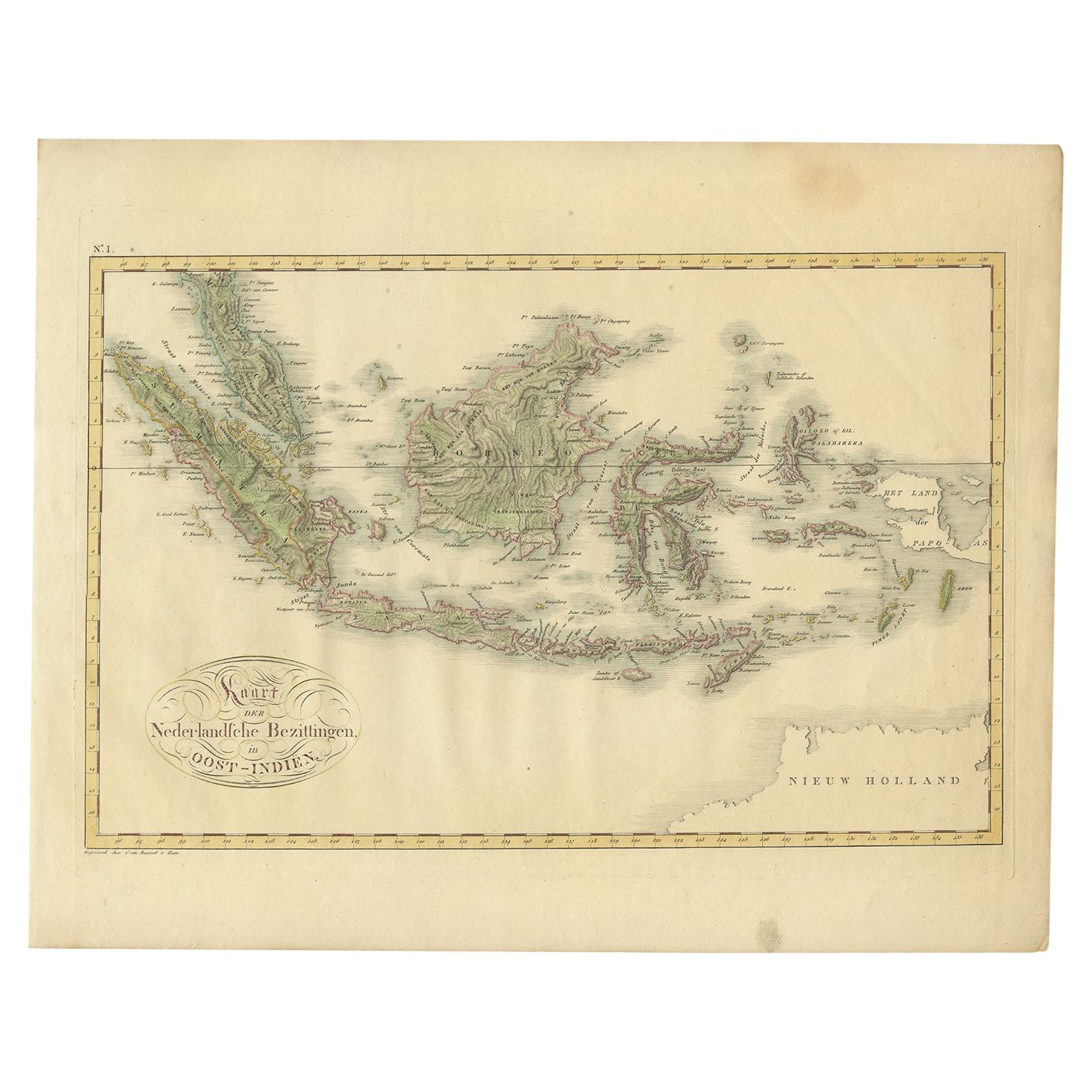
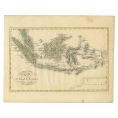
Antique map titled 'Kaart der Nederlandsche Bezittingen in Oost-Indiën'.
Rare and attractive map of the Dutch East Indies, it shows the Dutch possessions in the 19th century. This ...
Category
Antique Early 19th Century Maps
Materials
Paper
$1,051 Sale Price
35% Off
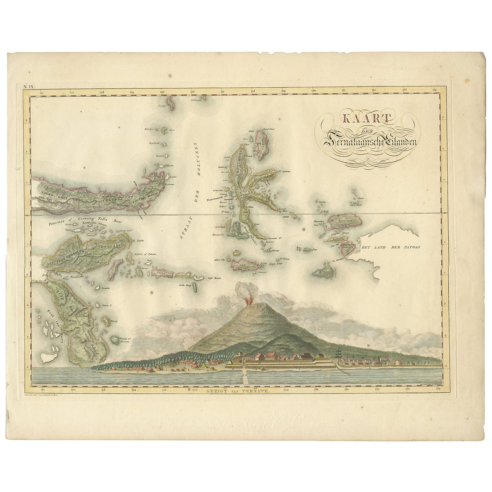
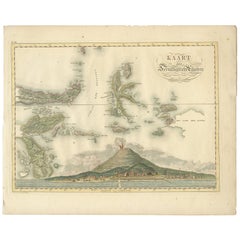
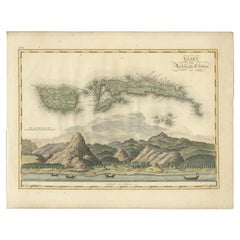
Antique Map of the Ternate Islands by Van den Bosch '1818'
Located in Langweer, NL
Antique map titled 'Kaart der Ternataansche Eilanden'. Rare and attractive map of the Ternate Islands with a large view of Ternate Island. One of 12 maps from 'Atlas van Overzeesche ...
Category
Antique Early 19th Century Maps
Materials
Paper
$1,039 Sale Price
25% Off
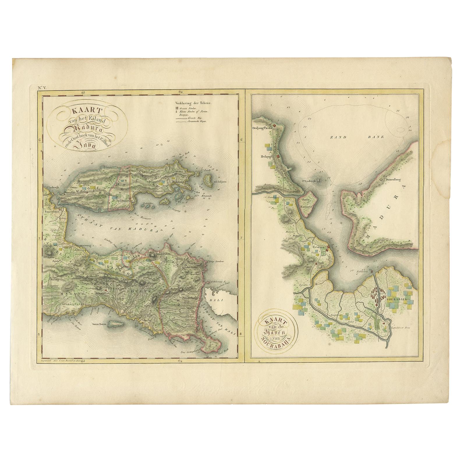
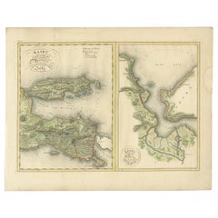
Antique Map of Madura and Surabaya by Van den Bosch, '1818'
Located in Langweer, NL
Two maps on one sheet titled 'Kaart van het Eiland Madura en de Oost hoek van het Eiland Java' and 'Kaart van de Haven van Sourabaija'. The left map shows East Java with the Island o...
Category
Antique Early 19th Century Maps
Materials
Paper
$1,109 Sale Price
20% Off
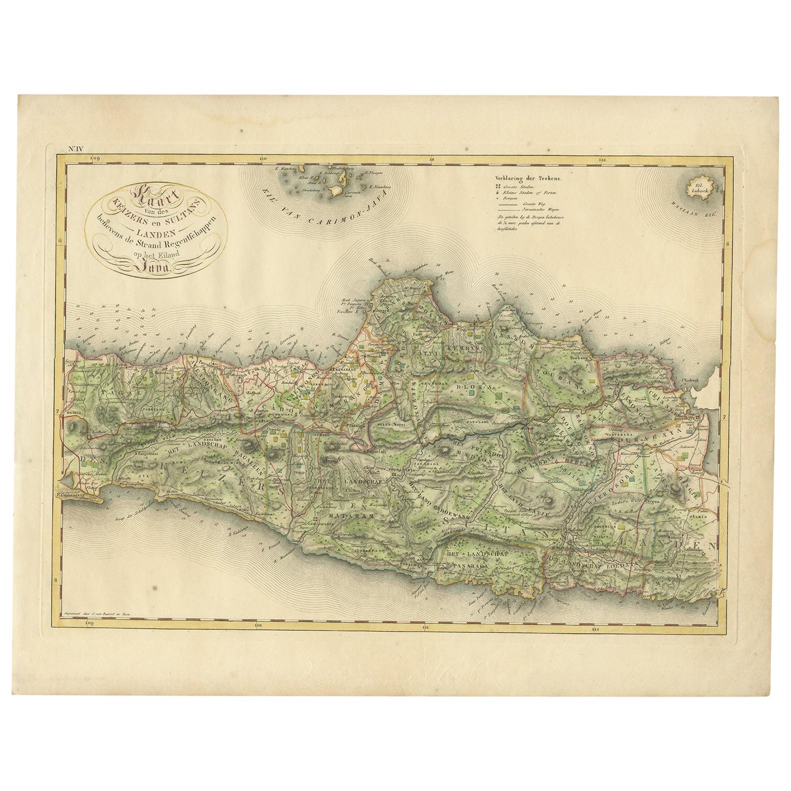
Antique Map of Central and East Java by Van den Bosch, 1818
Located in Langweer, NL
Antique map titled 'Kaart van de Keizers en Sultans Landen benevens de Strand Regentschappen op het Eiland Java'. Map of three central and easterly provinces of the island of Java. O...
Category
Antique Early 19th Century Maps
Materials
Paper

$1,109 Sale Price
20% Off
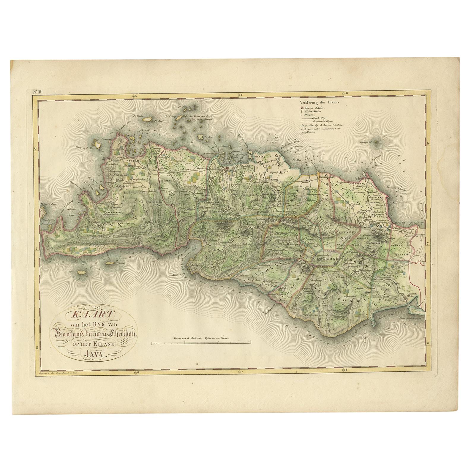
Antique Map of Bantam, Jakarta and Cirebon by Van den Bosch '1818'
Located in Langweer, NL
Antique map titled 'Kaart van het Ryk van Bantam, Jacatra, Cheribon op het Eiland Java'. Rare and attractive map of the three most easterly provinces of Java (Bantam, Jakarta and Cir...
Category
Antique Early 19th Century Maps
Materials
Paper
$1,109 Sale Price
20% Off
Antique Map of Seram, Boero and the Banda Islands by Van den Bosch '1818'
Located in Langweer, NL
Antique map titled 'Kaart der Ambonsche Eilanden'. Rare and attractive map of the islands of Seram, Boero and the Banda Islands. Includes a nice view of the Island of Seram. One of 1...
Category
Antique Early 19th Century Maps
Materials
Paper
$970 Sale Price
30% Off
You May Also Like
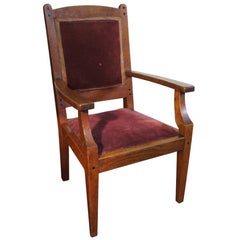
Arts and Crafts Children's or Miniature Chair Attributed to Jac van den Bosch
By Jac van den Bosch
Located in Lisse, NL
Unique tiger oak chair from the Dutch Arts & Crafts era.
Arts & Crafts children's chairs are a rare find and to have found an original Dutch one in th...
Category
Early 20th Century Dutch Arts and Crafts Models and Miniatures
Materials
Upholstery, Oak
West Coast of Africa, Guinea & Sierra Leone: An 18th Century Map by Bellin
By Jacques-Nicolas Bellin
Located in Alamo, CA
Jacques Bellin's copper-plate map entitled "Partie de la Coste de Guinee Dupuis la Riviere de Sierra Leona Jusquau Cap das Palmas", depicting the coast of Guinea and Sierra Leone in ...
Category
Antique Mid-18th Century French Maps
Materials
Paper

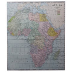
Large Original Antique Map of Africa. C.1900
Located in St Annes, Lancashire
Fabulous map of Africa
Original color.
Engraved and printed by the George F. Cram Company, Indianapolis.
Published, C.1900.
Unframed.
Free shipping.
Category
Antique 1890s American Maps
Materials
Paper
Dutch 'Nieuwe Kunst' Magazine Stand by Jac. van den Bosch, Netherlands, c. 1905
By 't Binnenhuis
Located in EVERDINGEN, NL
Very rare early 20th century magazine or paper stand by Jac. van den Bosch for 't Binnenhuis, ca. 1905. It's a very elegant as well as a functional piece, like van den Bosch intended...
Category
Antique Early 1900s Dutch Art Nouveau Magazine Racks and Stands
Materials
Bone, Ebony, Oak
Original Antique Map of South Africa, Arrowsmith, 1820
Located in St Annes, Lancashire
Great map of South Africa.
Drawn under the direction of Arrowsmith.
Copper-plate engraving.
Published by Longman, Hurst, Rees, Orme and Br...
Category
Antique 1820s English Maps
Materials
Paper

Northwest Coast and Isle of Man Map
Located in Cheshire, GB
Greenville Collins Northwest Coast and Isle of Man. hand coloured chart, encased in an ebonised frame.
Dimensions
Height 26.5 Inches
Width 30 Inches
Depth 1 Inches
Category
Early 20th Century British Maps
Materials
Paper

Recently Viewed
View AllMore Ways To Browse
Dutch Military
Anglo Dutch Furniture
Anglo Dutch
Anglo Portuguese
Antique Map Of Venice
Antique Maps Of Canada
Atlas Carrying World
Copper Soldiers
Virginia Map
Antique Maps New Zealand
Scottish Coat Of Arms
Antique Map Of Georgia
California Island Map
Indian Ocean Map
Antique Maps Persia
Antique Maps West Indies
Maps Of Dublin
Maps Tallis