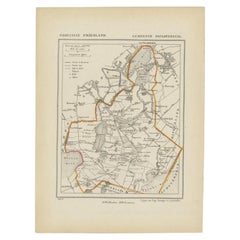
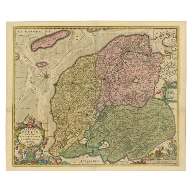
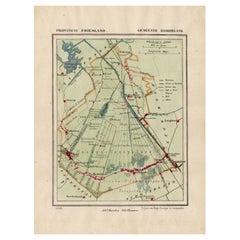
Antique Map of Doniawerstal in Friesland, Holland, 1868
View Similar Items
Want more images or videos?
Request additional images or videos from the seller
1 of 5
Antique Map of Doniawerstal in Friesland, Holland, 1868
About the Item
- Dimensions:Height: 10.44 in (26.5 cm)Width: 7.88 in (20 cm)Depth: 0 in (0.01 mm)
- Materials and Techniques:
- Period:
- Date of Manufacture:1868
- Condition:
- Seller Location:Langweer, NL
- Reference Number:Seller: BG-04638-41stDibs: LU3054326162072
About the Seller
5.0
Recognized Seller
These prestigious sellers are industry leaders and represent the highest echelon for item quality and design.
Platinum Seller
Premium sellers with a 4.7+ rating and 24-hour response times
Established in 2009
1stDibs seller since 2017
2,418 sales on 1stDibs
Authenticity Guarantee
In the unlikely event there’s an issue with an item’s authenticity, contact us within 1 year for a full refund. DetailsMoney-Back Guarantee
If your item is not as described, is damaged in transit, or does not arrive, contact us within 7 days for a full refund. Details24-Hour Cancellation
You have a 24-hour grace period in which to reconsider your purchase, with no questions asked.Vetted Professional Sellers
Our world-class sellers must adhere to strict standards for service and quality, maintaining the integrity of our listings.Price-Match Guarantee
If you find that a seller listed the same item for a lower price elsewhere, we’ll match it.Trusted Global Delivery
Our best-in-class carrier network provides specialized shipping options worldwide, including custom delivery.More From This Seller
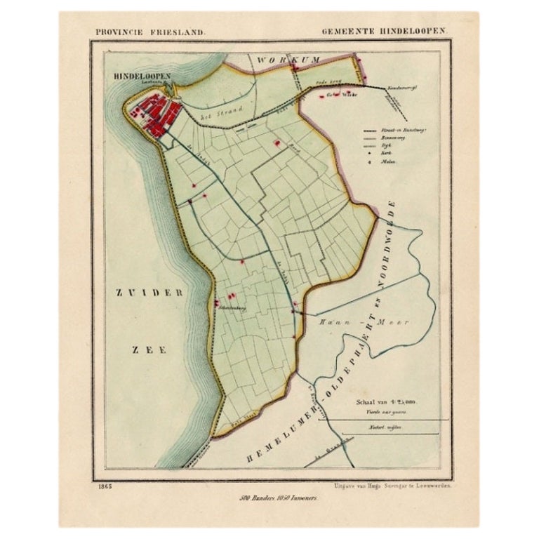
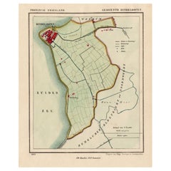
View AllAntique Map of Hindelopen, Picturesque Harbour City in Friesland, Holland, 1868
Located in Langweer, NL
Antique map titled 'Provincie Friesland - Gemeente Hindeloopen'.
Map of the township of Hindeloopen, Friesland. This map originates from 'Gemeente-Atlas van Nederland' by J. Kuyp...
Category
Antique 19th Century Maps
Materials
Paper
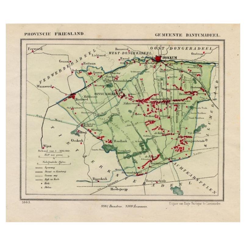
Antique Map of Dantumadeel, Friesland, The Netherlands, 1868
Located in Langweer, NL
Antique map titled 'Provincie Friesland - Gemeente Dantumadeel'. Map of the township of Dantumadeel including Birdaard, Rinsumageest, Veenwouden and many other villages. This map ori...
Category
Antique 19th Century Maps
Materials
Paper
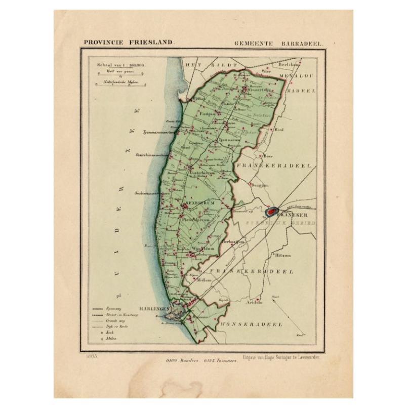
Antique Map of Barradeel, a County in Friesland, The Netherlands, 1868
Located in Langweer, NL
Antique map titled 'Provincie Friesland - Gemeente Barradeel or Barradiel. Map of the township Barradeel including Sexbierum, Harlingen and many other villages. This map originates f...
Category
Antique 19th Century Maps
Materials
Paper

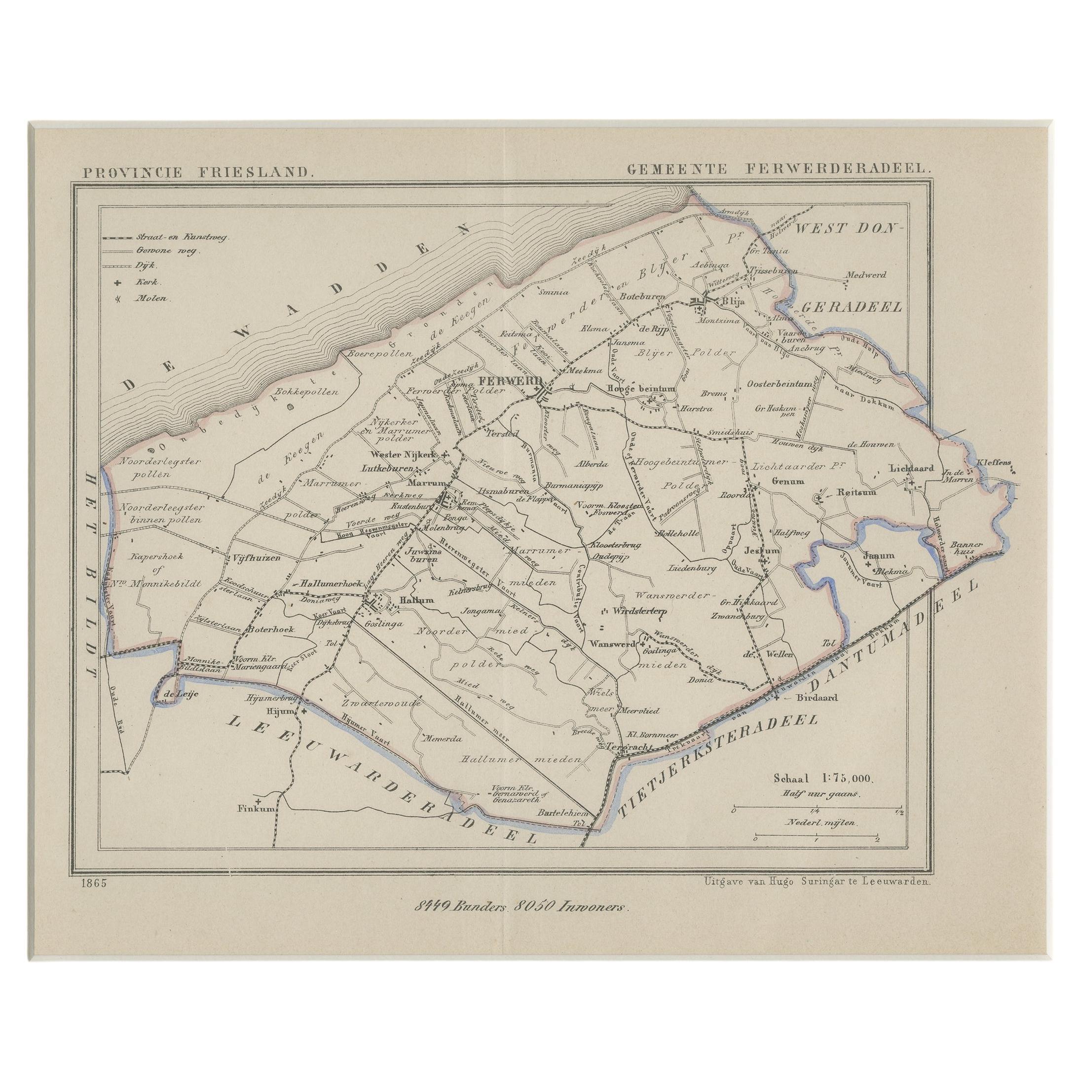
Antique Map of Ferwerderadeel, a County in Friesland, The Netherlands, 1868
Located in Langweer, NL
Antique map titled 'Provincie Friesland - Gemeente Ferwerderadeel'. Map of the township of Ferwerderadeel including Ferwerd, Blija and many other villages. This map originates from '...
Category
Antique 19th Century Maps
Materials
Paper
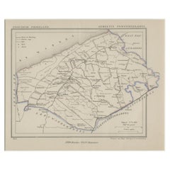
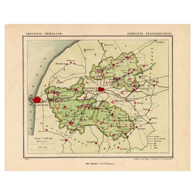
Antique Map of Franekeradeel, Township in Friesland, The Netherlands, 1868
Located in Langweer, NL
Antique map titled 'Provincie Friesland - Gemeente Franekeradeel'.
Map of the township of Franekeradeel including Franeker, Achlum, Dongjum, Midlum and many other villages. This ...
Category
Antique 19th Century Maps
Materials
Paper

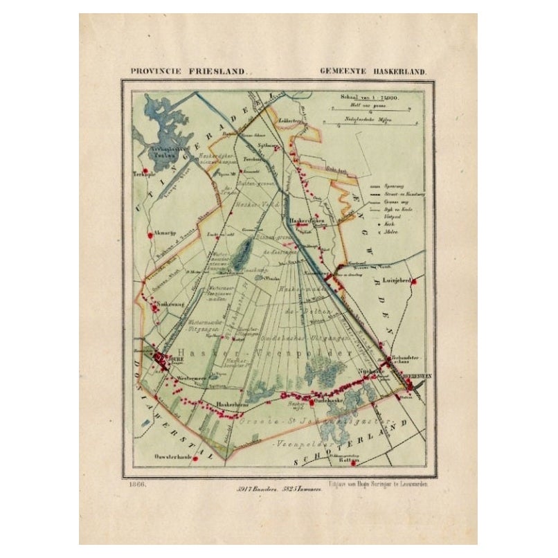
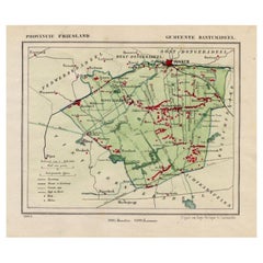
Antique Map of Haskerland, Township in Friesland, The Netherlands, 1868
Located in Langweer, NL
Antique map titled 'Provincie Friesland - Gemeente Haskerland'.
Map of the township of Haskerland including Haskerhorne, Joure, Oudehaske and many other villages. This map origin...
Category
Antique 19th Century Maps
Materials
Paper
You May Also Like
1868 "Lloyd's Topographical Railway Map of North America..." Hanging Wall Map
Located in Colorado Springs, CO
Presented is “Lloyd's Topographical Railway Map of North-America, or the United States Continent in 1900.” This map was published by J. T. Lloyd, in New York, in 1868. A large, hangi...
Category
Antique 1860s American Late Victorian Maps
Materials
Linen, Paper

Antique County Map of Cheshire, Dutch, Framed, Cartography, Janssonius, C.1660
Located in Hele, Devon, GB
This is an antique county map of Cheshire. A Dutch, framed atlas engraving by Johannes Janssonius, dating to the 17th century and later.
A treat for the collector or county native,...
Category
Antique Mid-17th Century Dutch Charles II Maps
Materials
Glass, Wood, Paper

Antique County Map, Buckinghamshire, Bedfordshire, Dutch, Framed, Janssonius
Located in Hele, Devon, GB
This is an antique county map of Buckinghamshire and Bedfordshire. A Dutch, framed atlas engraving by Johannes Janssonius, dating to the 17th century and later.
A treat for the col...
Category
Antique Mid-17th Century Dutch Maps
Materials
Paper

1868 Map of the Upper Part of the Island of Manhattan Above 86th Street
By Wm. Rogers Mfg. Co.
Located in San Francisco, CA
This wonderful piece of New York City history is over 150 years old. It depicts 86th street and above. It was lithographed by WC Rogers and company. It was made to show what was the Battle of Harlem during the Revolutionary war...
Category
Antique 1860s American American Colonial Maps
Materials
Paper

Antique Map of Principality of Monaco
By Antonio Vallardi Editore
Located in Alessandria, Piemonte
ST/619 - "Old Geographical Atlas of Italy - Topographic map of ex-Principality of Monaco" -
ediz Vallardi - Milano -
A somewhat special edition ---
Category
Antique Late 19th Century Italian Other Prints
Materials
Paper

Geographical Antique Map of Principality of Monaco
By Bruno Santini
Located in Alessandria, Piemonte
ST/609 - Interesting antique color map of Monaco Principality in French language : "Carte qui contient le Principauté de Piémont, le Monferrat et la comté de...
Category
Antique Late 18th Century Italian Other Maps
Materials
Paper

Recently Viewed
View AllMore Ways To Browse
1868 Furniture
Bench Leather Seat Cushion
Black Aluminum Outdoor Sofa
Borge Mogensen Dining Chairs
Bottle Pourer
Brown Velvet Accent Chairs
Brutalist Oak Console
Cantilever Office Chair
Chair With Table Attached
Charles Hollis Jones Lucite Dining Table
Charlotte Perriand Les Arcs
Chrome Craft Sofa
Chrome Dining Chairs Post Modern
Country French Table With Drawer
Custom Trunk
Cut Crystal Decanters
Danish Drop Leaf Table
Danish Modern Pitcher