Items Similar to Antique Map of the Coastline Between Calais and Estaples and Northern France


Want more images or videos?
Request additional images or videos from the seller
1 of 6
Antique Map of the Coastline Between Calais and Estaples and Northern France
About the Item
Antique map titled 'Caletensium et Bononiensium Ditionis Accurata Delinatio [on sheet with] Veromanduorum Eorumque Confinium Exactissima Discriptio'. Two maps on a folio sheet. Calentensium covers the coastline between Calais and Estaples based in part on a four-sheet map by Nicolas de Nicolay. Veromanduorum covers a small region surrounding Saint-Quentin in northern France. Each is covered with tiny forests and cities and has a decorative title cartouche. This map originates from a Spanish edition of 'Theatrum Orbis Terrarum' by A. Ortelius. Published circa 1612.
Abraham Ortelius is perhaps the best known and most frequently collected of all sixteenth-century mapmakers. Ortelius started his career as a map engraver. In 1547 he entered the Antwerp guild of St Luke as afsetter van Karten. His early career was as a business man, and most of his journeys before 1560 were for commercial purposes. In 1560, while traveling with Gerard Mercator to Trier, Lorraine, and Poitiers, he seems to have been attracted, largely by Mercator’s influence, towards a career as a scientific geographer. From that point forward, he devoted himself to the compilation his Theatrum Orbis Terrarum (Theatre of the World), which would become the first modern atlas.
- Dimensions:Height: 19.02 in (48.3 cm)Width: 22.96 in (58.3 cm)Depth: 0.02 in (0.5 mm)
- Materials and Techniques:
- Period:Early 17th Century
- Date of Manufacture:c.1612
- Condition:Age-related toning. Original folding line. Shows wear and soiling. Spanish text on verso. Please study image carefully.
- Seller Location:Langweer, NL
- Reference Number:Seller: BG-13397-201stDibs: LU3054333827082
About the Seller
5.0
Recognized Seller
These prestigious sellers are industry leaders and represent the highest echelon for item quality and design.
Platinum Seller
Premium sellers with a 4.7+ rating and 24-hour response times
Established in 2009
1stDibs seller since 2017
2,419 sales on 1stDibs
Typical response time: <1 hour
- ShippingRetrieving quote...Shipping from: Langweer, Netherlands
- Return Policy
Authenticity Guarantee
In the unlikely event there’s an issue with an item’s authenticity, contact us within 1 year for a full refund. DetailsMoney-Back Guarantee
If your item is not as described, is damaged in transit, or does not arrive, contact us within 7 days for a full refund. Details24-Hour Cancellation
You have a 24-hour grace period in which to reconsider your purchase, with no questions asked.Vetted Professional Sellers
Our world-class sellers must adhere to strict standards for service and quality, maintaining the integrity of our listings.Price-Match Guarantee
If you find that a seller listed the same item for a lower price elsewhere, we’ll match it.Trusted Global Delivery
Our best-in-class carrier network provides specialized shipping options worldwide, including custom delivery.More From This Seller
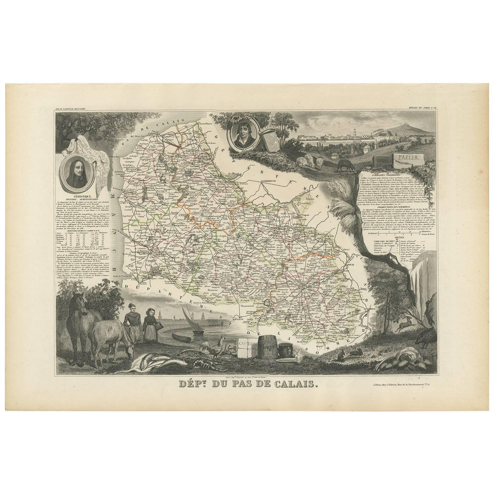
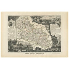
View AllHand Colored Antique Map of the Department of Calais, France
By Victor Levasseur
Located in Langweer, NL
Antique map titled 'Dépt. du Pas de Calais'. Map of the French department of Calais, France. This area is known for producing Maroilles, a soft cheese made from cow’s milk and with a...
Category
Antique Mid-19th Century Maps
Materials
Paper
Antique Map of Calais ‘France’ by V. Levasseur, 1854
By Victor Levasseur
Located in Langweer, NL
Antique map titled 'Dépt. du Pas de Calais'. Map of the French department of Calais, France. This area is known for producing Maroilles, a soft cheese made from cow’s milk and with a...
Category
Antique Mid-19th Century Maps
Materials
Paper
$167 Sale Price
20% Off
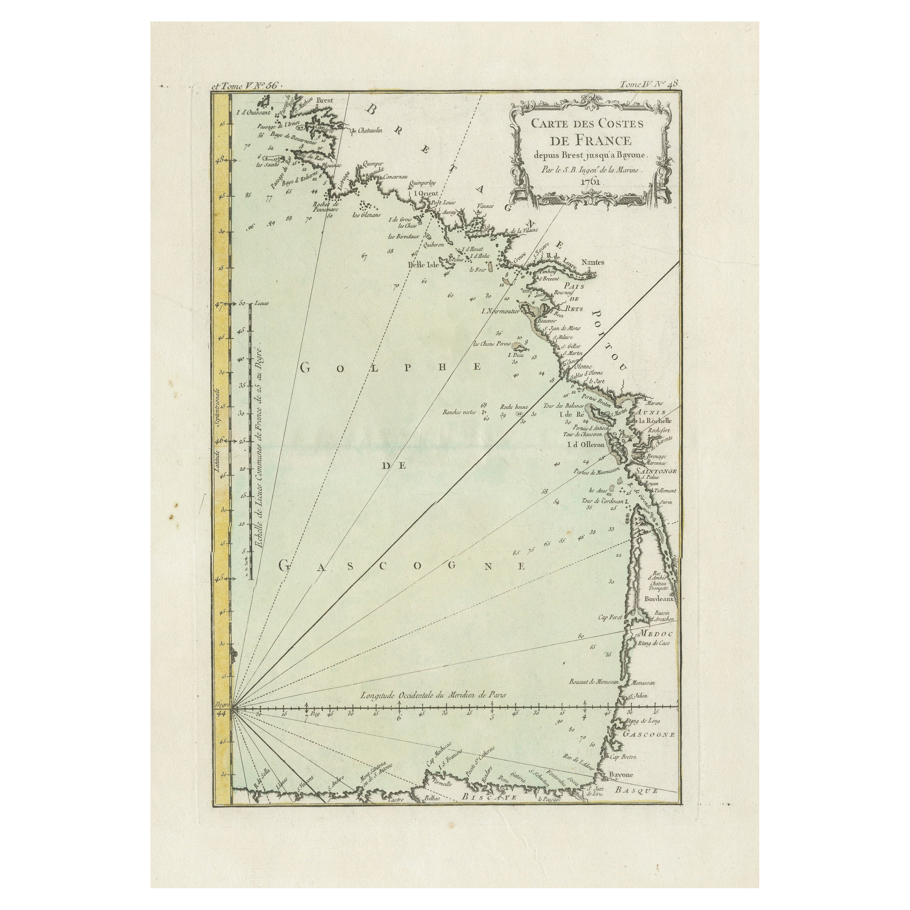
Antique Map of the Coast of France Between Brest and Bayonne
Located in Langweer, NL
Antique map titled 'Carte des Costes de France depuis Brest jusquá Bayone'. Original old map of the coast of France between Brest and Bayonne. This map originates from 'Le Petit Atla...
Category
Antique Mid-18th Century Maps
Materials
Paper
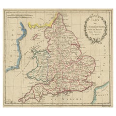
Antique Map of England, Also Showing Calais
Located in Langweer, NL
Antique map titled 'Carte de l'Angleterre pour le Voyage dans les trois Royaumes'. Original old map of England, also showing Calais. This map originates from 'Voyage dans les trois r...
Category
Antique Late 18th Century Maps
Materials
Paper
Antique Map: Estuaries of the Somme & Bresle, Northern France & Netherlands
By Jacobus Harrewijn
Located in Langweer, NL
Antique Map: Les Embouchures de la Somme et de Bresle (Estuaries of the Somme and Bresle)
This beautifully detailed antique map, titled *Les Embouchures de la Somme et de Bresle*, showcases the coastline of northern France, specifically focusing on the estuaries of the Somme and Bresle rivers. Part of a larger series of maps that collectively depict a significant portion of the Southern Netherlands, this engraving captures the intricate geography of the region with remarkable precision.
The map provides a detailed view of the coastal towns, rivers, and natural features that define the area. Notable locations such as Dieppe and St. Valery are highlighted, reflecting their historical significance as key port towns and hubs of trade and navigation. The surrounding rivers and estuaries are meticulously rendered, showing the natural waterways that played a crucial role in the development of the region.
This engraving is enhanced by the inclusion of charming decorative elements, such as sailing ships in the surrounding waters, adding a sense of movement and life to the map. The inclusion of forests and topographical details in the inland areas demonstrates the mapmaker's commitment to providing a comprehensive representation of the region.
The map's historical context lies in its origin as part of a series that aimed to document the territories of the Southern Netherlands and northern France during a period of significant political and geographical change in Europe. Such maps were invaluable tools for navigation, trade, and territorial administration, making them both functional and artistic.
Keywords: antique map of Northern France, Somme estuary map, Bresle estuary, Dieppe historical map, Southern Netherlands cartography, French coastline map, 17th-century map engraving, historical geography, decorative antique map, rare European maps, maritime history.
This map is an exceptional piece for collectors of antique cartography...
Category
Antique Early 18th Century Maps
Materials
Paper

$395 Sale Price
60% Off
Free Shipping
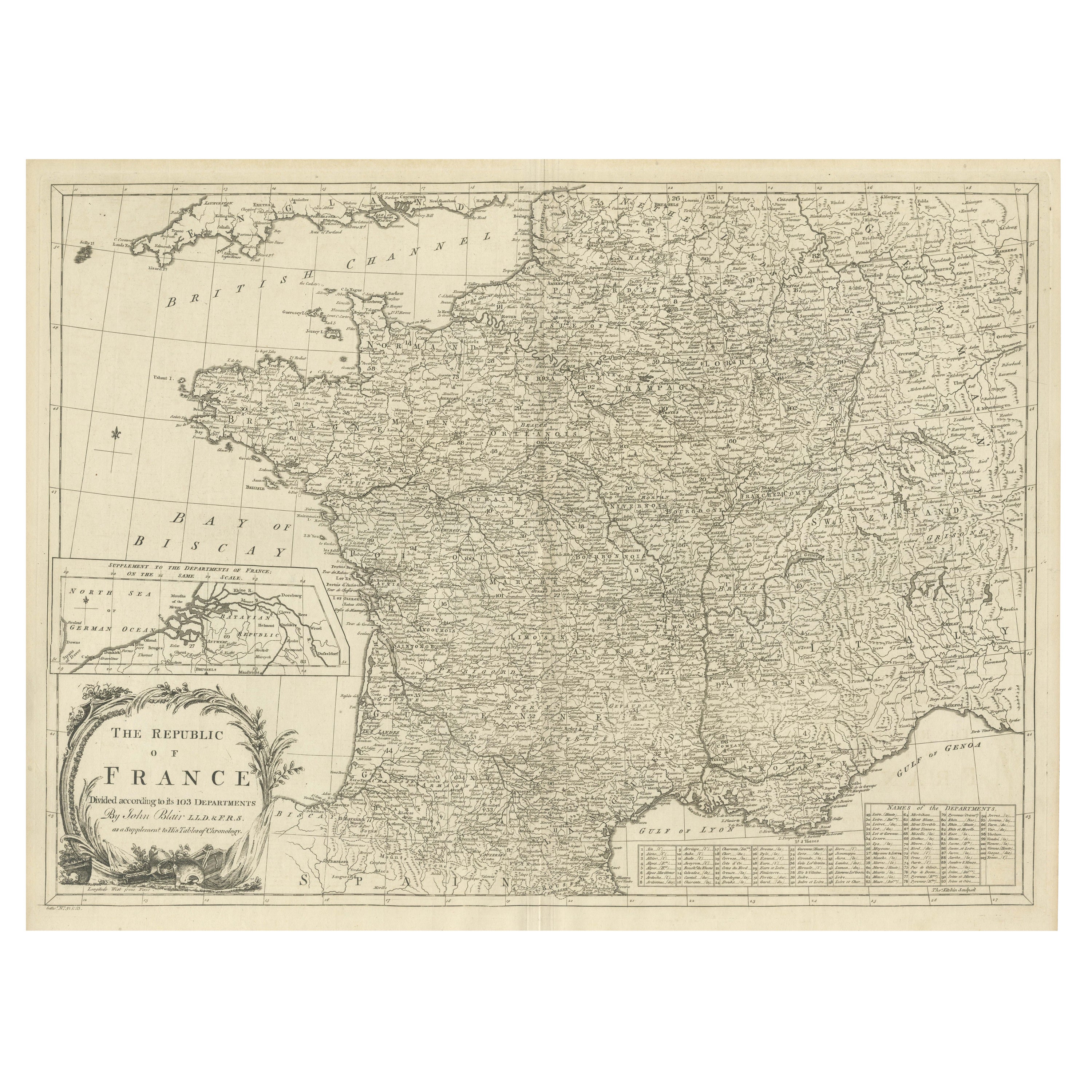
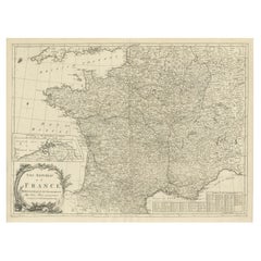
Antique Map of France with Inset showing the Northern Departments
Located in Langweer, NL
Antique map titled 'The Republic of France divided according to its 103 Departments'. Decorative map of France. Includes a large cartouche and an in...
Category
Antique Late 18th Century Maps
Materials
Paper
You May Also Like
Map of the Republic of Genoa
Located in New York, NY
Framed antique hand-coloured map of the Republic of Genoa including the duchies of Mantua, Modena, and Parma.
Europe, late 18th century.
Dimension: 25...
Category
Antique Late 18th Century European Maps

Antique Map of Principality of Monaco
By Antonio Vallardi Editore
Located in Alessandria, Piemonte
ST/619 - "Old Geographical Atlas of Italy - Topographic map of ex-Principality of Monaco" -
ediz Vallardi - Milano -
A somewhat special edition ---
Category
Antique Late 19th Century Italian Other Prints
Materials
Paper

Antique 18th Century Map of the Province of Pensilvania 'Pennsylvania State'
Located in Philadelphia, PA
A fine antique of the colony of Pennsylvania.
Noted at the top of the sheet as a 'Map of the province of Pensilvania'.
This undated and anonymous map is thought to be from the Gentleman's Magazine, London, circa 1775, although the general appearance could date it to the 1760's.
The southern boundary reflects the Mason-Dixon survey (1768), the western boundary is placed just west of Pittsburgh, and the northern boundary is not marked.
The map has a number of reference points that likely refer to companion text and appear to be connected to boundaries. The western and southern boundaries are marked Q, R, S, for example. A diagonal line runs from the Susquehanna R to the Lake Erie P. A broken line marked by many letters A, B, N, O, etc., appears in the east.
There are no latitude or longitude markings, blank verso.
Framed in a shaped contemporary gilt wooden frame and matted under a cream colored matte.
Bearing an old Graham Arader Gallery...
Category
Antique 18th Century British American Colonial Maps
Materials
Paper

Original Antique Map of The World by Thomas Clerk, 1817
Located in St Annes, Lancashire
Great map of The Eastern and Western Hemispheres
On 2 sheets
Copper-plate engraving
Drawn and engraved by Thomas Clerk, Edinburgh.
Published by Mackenzie And Dent, 1817
...
Category
Antique 1810s English Maps
Materials
Paper

Map "Estuary- Mouth of the Thames"
Located in Alessandria, Piemonte
ST/426 - Antique French Map of the estuary of the Thames, map dated 1769 -
"Mape of the entrance of the Thames. Designed by filing of Navy cards fo...
Category
Antique Mid-18th Century French Other Prints
Materials
Paper

Original Antique Map of Spain and Portugal, circa 1790
Located in St Annes, Lancashire
Super map of Spain and Portugal
Copper plate engraving by A. Bell
Published, circa 1790.
Unframed.
Category
Antique 1790s English Other Maps
Materials
Paper

Recently Viewed
View AllMore Ways To Browse
16th Century Antique Tapestry
18th Century Silver Spoon
1960s Vintage Club Chair
21st Century Art Deco Sofa
40 Inch Coffee Tables
70s Leather Armchair
72 Round Dining Table
9x12 Area Rug Green
Alp Chair
Antique Salt Cellars
Antique Upholstered Bed
Antique Wood Ladders
Armchair Pierre Frey
Art Deco 1920s Sofa
Art Deco Kids
Art Deco Serving Spoon
Barcelona Bench
Bjorn Wiinblad Glass