Items Similar to Antique Map of the City of Oldenzaal by Orlers, 1615


Want more images or videos?
Request additional images or videos from the seller
1 of 5
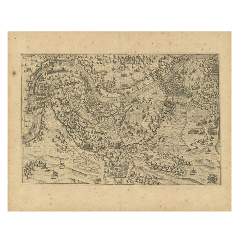
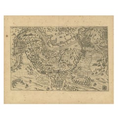
Antique Map of the City of Oldenzaal by Orlers, 1615
About the Item
Antique map depicting the Siege of Oldenzaal, the Netherlands. The Siege of Oldenzaal was a short siege that took place during the Eighty Years' War and the Anglo–Spanish War by a Dutch and English army led by Maurice of Orange of the city of Oldenzaal from 20 to 23 October 1597. The city surrendered to the overwhelming Dutch and English force. The siege was part of Maurice's Campaign of 1597 known as the Ten Glory Years, his highly successful offensive against the Spaniards. This map originates from 'La genealogie des illustres Comtes de Nassau' by Jan Jansz. Orlers.
Artists and Engravers: Jan Janszoon Orlers (1570 - 1646), Dutch historian.
Condition: Good, age-related toning. Please study image carefully.
Date: 1615
Overall size: 37 x 31 cm.
Image size: 31 x 22 cm.
We sell original antique maps to collectors, historians, educators and interior decorators all over the world. Our collection includes a wide range of authentic antique maps from the 16th to the 20th centuries. Buying and collecting antique maps is a tradition that goes back hundreds of years. Antique maps have proved a richly rewarding investment over the past decade, thanks to a growing appreciation of their unique historical appeal. Today the decorative qualities of antique maps are widely recognized by interior designers who appreciate their beauty and design flexibility. Depending on the individual map, presentation, and context, a rare or antique map can be modern, traditional, abstract, figurative, serious or whimsical. We offer a wide range of authentic antique maps for any budget.
- Dimensions:Height: 12.21 in (31 cm)Width: 14.57 in (37 cm)Depth: 0 in (0.01 mm)
- Materials and Techniques:
- Period:
- Date of Manufacture:1615
- Condition:
- Seller Location:Langweer, NL
- Reference Number:Seller: BG-003771stDibs: LU3054327793482
About the Seller
5.0
Recognized Seller
These prestigious sellers are industry leaders and represent the highest echelon for item quality and design.
Platinum Seller
Premium sellers with a 4.7+ rating and 24-hour response times
Established in 2009
1stDibs seller since 2017
2,412 sales on 1stDibs
Typical response time: 1 hour
- ShippingRetrieving quote...Shipping from: Langweer, Netherlands
- Return Policy
Authenticity Guarantee
In the unlikely event there’s an issue with an item’s authenticity, contact us within 1 year for a full refund. DetailsMoney-Back Guarantee
If your item is not as described, is damaged in transit, or does not arrive, contact us within 7 days for a full refund. Details24-Hour Cancellation
You have a 24-hour grace period in which to reconsider your purchase, with no questions asked.Vetted Professional Sellers
Our world-class sellers must adhere to strict standards for service and quality, maintaining the integrity of our listings.Price-Match Guarantee
If you find that a seller listed the same item for a lower price elsewhere, we’ll match it.Trusted Global Delivery
Our best-in-class carrier network provides specialized shipping options worldwide, including custom delivery.More From This Seller
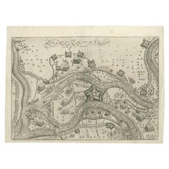
View AllAntique Map of the Region of Grave by Orlers, 1615
Located in Langweer, NL
Antique map of the region of Grave, also including Cuijk and Ravestein. This map originates from 'La genealogie des illustres Comtes de Nassau' by Jan Jansz. Orlers.
Artists and E...
Category
Antique 17th Century Maps
Materials
Paper
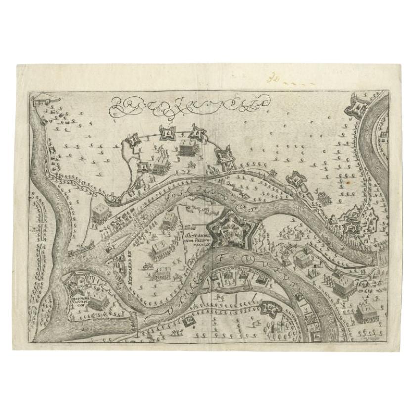
Antique Map of St. Andries 'Heerewaarden' by Orlers, 1615
Located in Langweer, NL
Antique map titled 'Prata Inundata'. This map depicts the area between the Maas and Waal river (The Netherlands) during the siege of St. Andries and Voorne under command of prince Ma...
Category
Antique 17th Century Maps
Materials
Paper
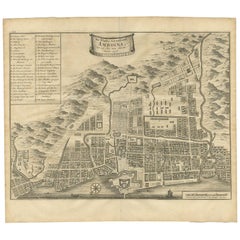
Antique Map of the City of Ambon by Valentijn, 1726
By F. Valentijn
Located in Langweer, NL
Antique map titled 'De Platte Grond van Amboina zoo als het was in den Jaare, 1718'. Antique map depicting the City of Ambon, Indonesia. This print originates from 'Oud en Nieuw Oost...
Category
Antique Early 18th Century Dutch Maps
Materials
Paper
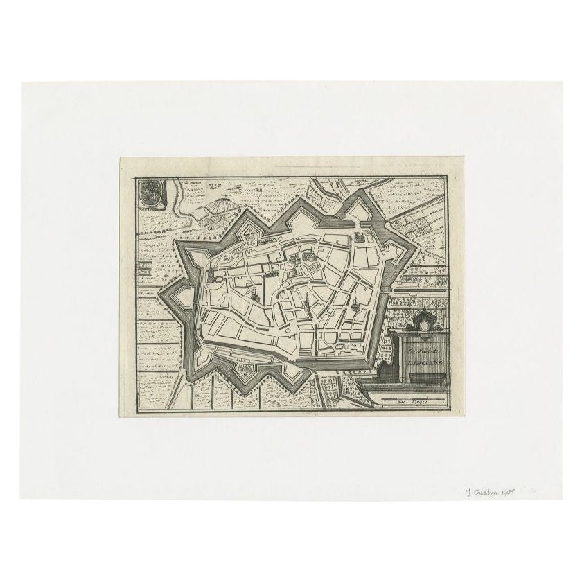
Antique Map of the City of Leeuwarden by Christyn, 1785
Located in Langweer, NL
Antique map titled 'La Ville de Lewarde'. Old map of the city of Leeuwarden, Friesland. Originates from 'Les Délices des Pays-Bas' by J.B. Christyn.
Artists and Engravers: Author:...
Category
Antique 18th Century Maps
Materials
Paper

Antique Map of the City of London by Balbi '1847'
Located in Langweer, NL
Antique map titled 'London'. Original antique map of the city of London. This map originates from 'Abrégé de Géographie (..)' by Adrien Balbi. Published 1847.
Category
Antique Mid-19th Century Maps
Materials
Paper

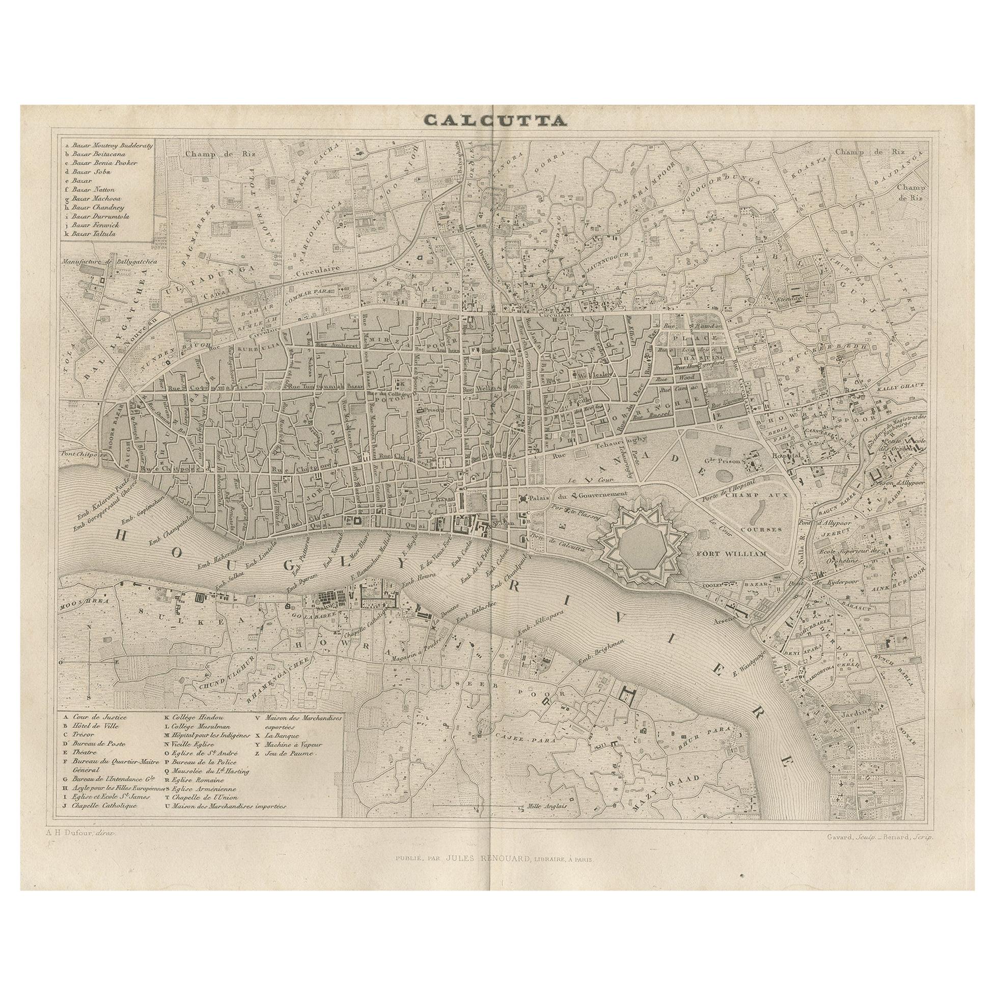
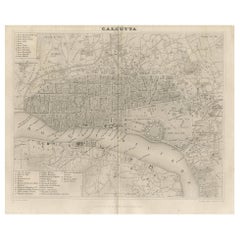
Antique Map of the City of Kolkata by Balbi '1847'
Located in Langweer, NL
Antique map titled 'Calcutta'. Original antique map of the city of Kolkata, India. This map originates from 'Abrégé de Géographie (..)' by Adrien Balbi. Published 1847.
Category
Antique Mid-19th Century Maps
Materials
Paper
$138 Sale Price
20% Off
You May Also Like
1840 Map of the City of Washington Published by William M. Morrison
Located in Colorado Springs, CO
This map, printed in 1840, is a detailed representation of Washington, D.C. in the mid-19th century. The map shows block numbers, wards, and government buildings as well as details o...
Category
Antique 1840s American Federal Maps
Materials
Paper

Antique Map of American Cities, Vignette of New York City, circa 1920
Located in St Annes, Lancashire
Great maps of American Cities
Unframed
Original color
By John Bartholomew and Co. Edinburgh Geographical Institute
Published, circa 1920
Category
Vintage 1920s British Maps
Materials
Paper

Italian Parchment Map of the City of Pisa Dated, 1640
By Matthäus Merian the Elder
Located in Florence, Tuscany
An antique map of the Tuscan city of Pisa engraved for The 'Itinerarium Italiæ Nov-antiquæ' by Matthäus Merian the Elder and printed in 1640....
Category
Antique 1640s Italian Maps
Materials
Paper

Original Antique Map of The Philippines. C.1900
Located in St Annes, Lancashire
Fabulous map of The Philippines
Original color.
Engraved and printed by the George F. Cram Company, Indianapolis.
Published, C.1900.
Unframed.
Free shipping.
Category
Antique 1890s American Maps
Materials
Paper

Original Antique Map of The World by Thomas Clerk, 1817
Located in St Annes, Lancashire
Great map of The Eastern and Western Hemispheres
On 2 sheets
Copper-plate engraving
Drawn and engraved by Thomas Clerk, Edinburgh.
Published by Mackenzie And Dent, 1817
...
Category
Antique 1810s English Maps
Materials
Paper

1840 "New Map of the City of New York With Part of Brooklyn & Williamsburg"
Located in Colorado Springs, CO
Presented is a hand-colored, engraved folding map titled "New Map of the City of New York With Part of Brooklyn & Williamsburg" by J. Calvin Smith. The map was issued bound in the bo...
Category
Antique 1840s American Maps
Materials
Paper

Recently Viewed
View AllMore Ways To Browse
Anglo Dutch Furniture
Anglo Dutch
Carolina Seating Chairs
Cast Iron End Table
Chaise Lounge Chair French
Cheese Table
Chinese 3 Piece Silver
Chinese Tea Table
Chinese Wood Sofas
Chinese Wood Wall Panel
Coat Large Hanger
Coffee Table Tree Mid Century
Colonial Tropical
Coupe Set
Crown Silver Co
Danish Leather Footstool
Demi Lune Table With Carved Legs
Divina Sofa