Items Similar to Antique Map of British India with Insets of Kabul and Nepal
Want more images or videos?
Request additional images or videos from the seller
1 of 6
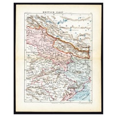
Antique Map of British India with Insets of Kabul and Nepal
About the Item
Antique map titled 'British India, northern part'. Large format map of the northern area of the Indian subcontinent. The map is engraved in the minimalist English style pioneered in the early part of the 19th century, a style which reduced maps’ decorative elements to a minimum. Relief is shown by hachure with towns, cities, and major topographical features identified. A large inset above the main map depicts Nepal in great detail, and to its left a smaller inset depicts the environs of Kabul, Afghanistan.
Drawn and engraved for Thomson's 'New General Atlas', 1817. John Thomson (1777 - 1841) was a Scottish cartographer, publisher, and bookbinder active in Edinburgh during the early part of the 19th century. Thomson apprenticed under Edinburgh bookbinder Robert Alison. Thomson was one of the leading publishers in the Edinburgh school of cartography, which flourished in the early decades of the 19th century. Thomson and his contemporaries (Pinkerton and Cary) redefined European cartography by abandoning typical 18th century decorative elements such as elaborate title cartouches and fantastic beasts in favor of detail and accuracy.
- Dimensions:Height: 21.38 in (54.3 cm)Width: 25.12 in (63.8 cm)Depth: 0.02 in (0.5 mm)
- Materials and Techniques:
- Period:
- Date of Manufacture:1817
- Condition:Original/contemporary hand coloring. Original folding line. Shows some wear and soiling. Blank verso. Please study image carefully.
- Seller Location:Langweer, NL
- Reference Number:Seller: BG-135031stDibs: LU3054336013442
About the Seller
5.0
Recognized Seller
These prestigious sellers are industry leaders and represent the highest echelon for item quality and design.
Platinum Seller
Premium sellers with a 4.7+ rating and 24-hour response times
Established in 2009
1stDibs seller since 2017
2,415 sales on 1stDibs
Typical response time: 1 hour
- ShippingRetrieving quote...Shipping from: Langweer, Netherlands
- Return Policy
Authenticity Guarantee
In the unlikely event there’s an issue with an item’s authenticity, contact us within 1 year for a full refund. DetailsMoney-Back Guarantee
If your item is not as described, is damaged in transit, or does not arrive, contact us within 7 days for a full refund. Details24-Hour Cancellation
You have a 24-hour grace period in which to reconsider your purchase, with no questions asked.Vetted Professional Sellers
Our world-class sellers must adhere to strict standards for service and quality, maintaining the integrity of our listings.Price-Match Guarantee
If you find that a seller listed the same item for a lower price elsewhere, we’ll match it.Trusted Global Delivery
Our best-in-class carrier network provides specialized shipping options worldwide, including custom delivery.More From This Seller
View AllAntique Map of Northeastern India, Nepal, Bhutan, Assam and Bangladesh
Located in Langweer, NL
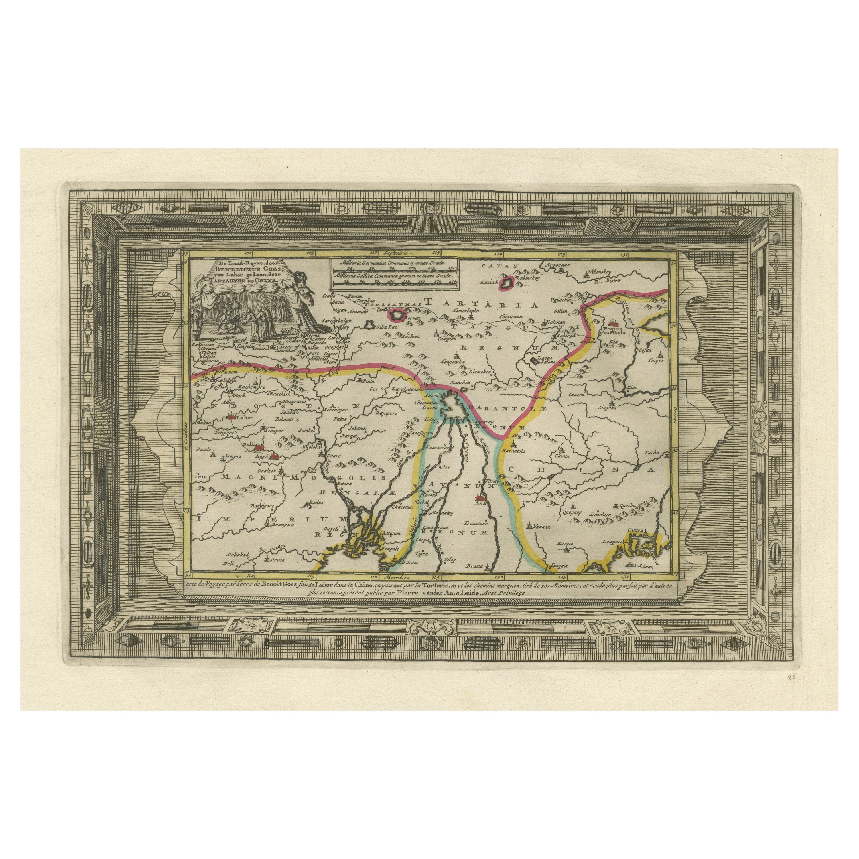
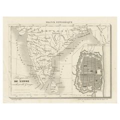
Antique map titled 'De Land-Reyse door Benedictus Goes, van Lahor gedaan, door Tartaryen na China'. Interesting map showing the region of northeastern India, Nepal, Bhutan, Assam and...
Category
Antique Early 18th Century Maps
Materials
Paper
Antique Map of India with Inset of Puducherry by Monin, 1835
Located in Langweer, NL
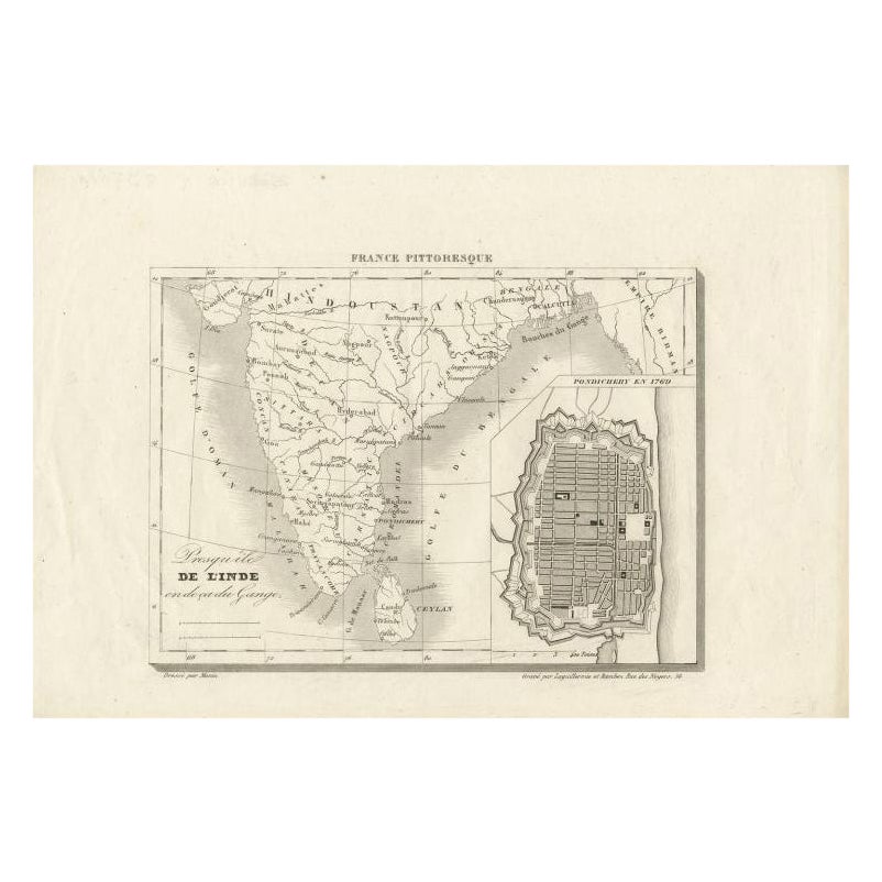
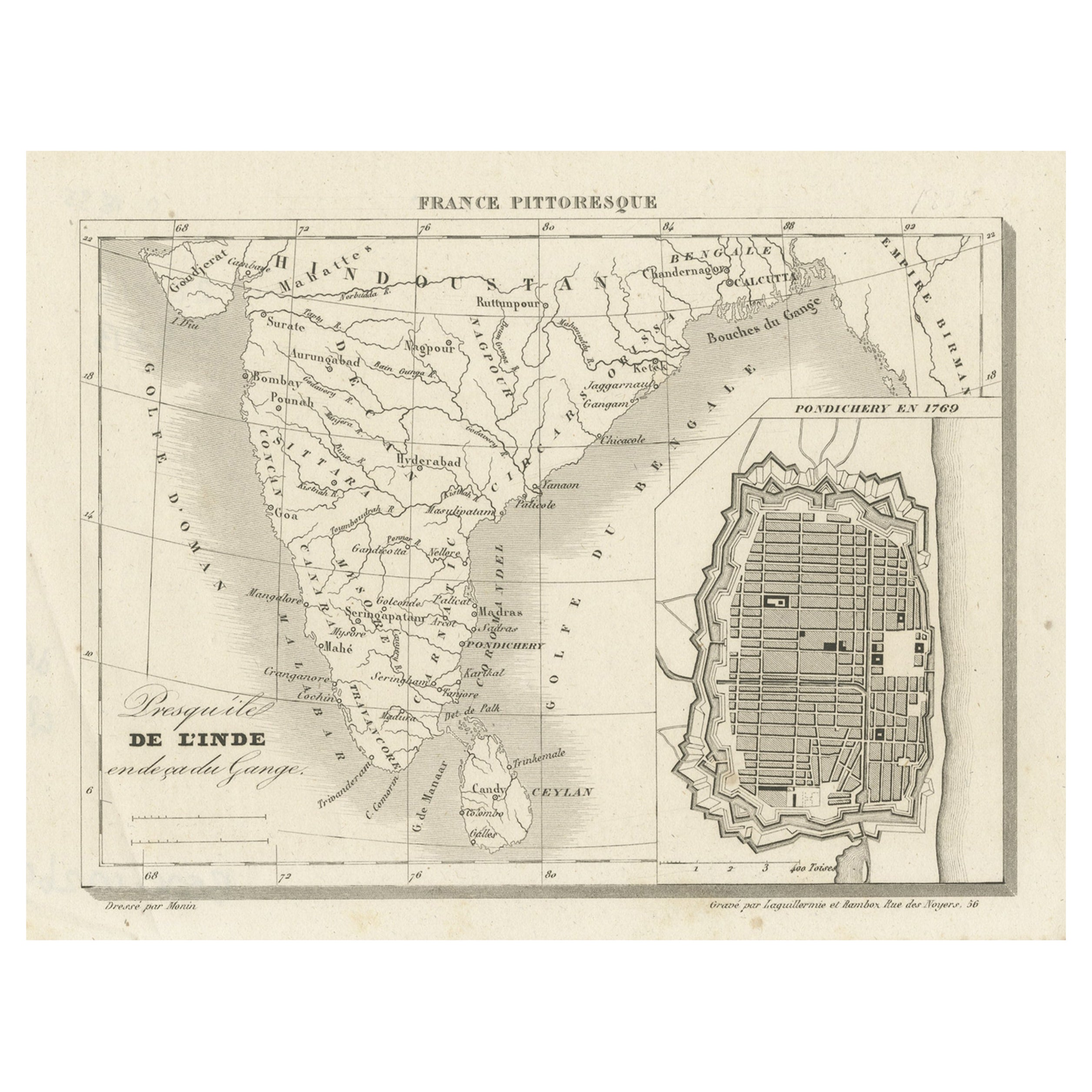
Antique map India titled 'Presqu'ile de l'Inde en de ca du Gange'. Miniature map depicting India with an inset map of Pondicherry (Puducherry). This ...
Category
Antique 19th Century Maps
Materials
Paper
French Antique Map of India with an Inset of Pondicherry, 1835
Located in Langweer, NL
Antique map India titled 'Presqu'ile de l'Inde en de ca du Gange'. Miniature map depicting India with an inset map of Pondicherry (Puducherry). This ...
Category
Antique 19th Century Maps
Materials
Paper
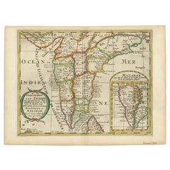
1705 Sanson Map of Southern India and Malabar with an Inset Map
Located in Langweer, NL
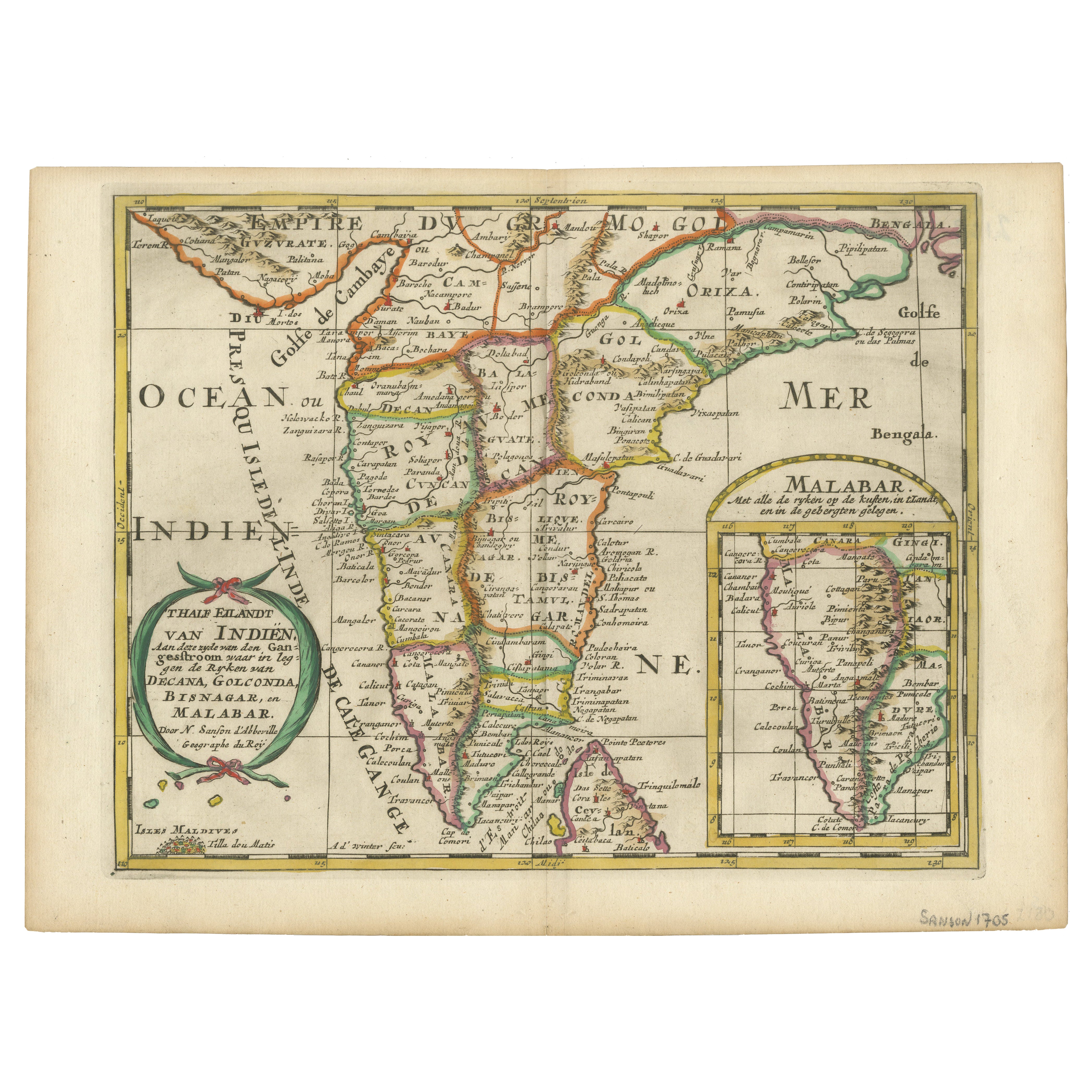
Title: 1705 Sanson Map of Southern India and Malabar with an Inset Map
Description: This finely engraved and beautifully hand-colored antique map, published in 1705, depicts south...
Category
Antique Early 1700s Maps
Materials
Paper
$711 Sale Price
20% Off
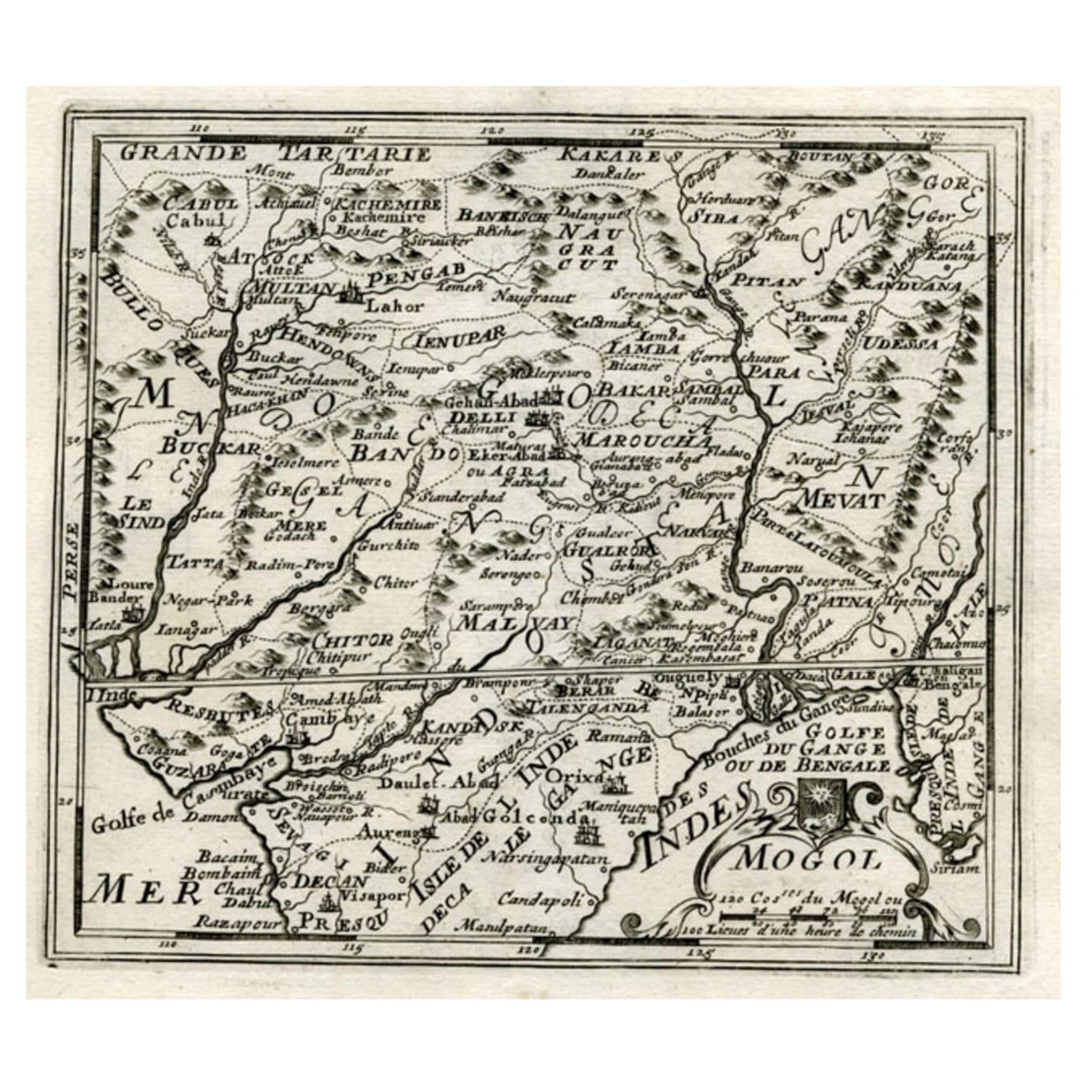
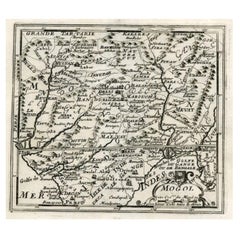
Map of Northern India and Pakistan 'Mogol', Showing Kabul, Delhi Etc., 1758
Located in Langweer, NL
Antique map titled 'Mogol'.
Map of Northern India and Pakistan ('Mogol'), showing Kabul, Delhi and surroundings. This map originates from 'Kort begrip der Oude en Nieuwe Staatkun...
Category
Antique 1750s Maps
Materials
Paper
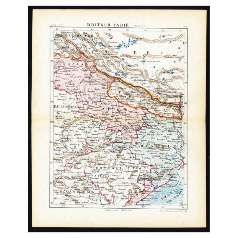
Antique Map of Northern India 'British Indies', C.1880
Located in Langweer, NL
Plate 56 : 'Britsch-Indie, Noord.' (British Indies, North). This lithographed map originates from: 'Wereld-atlas voor Kantoor en Huiskamer' (transl: World Atlas for the office and li...
Category
Antique 19th Century Maps
Materials
Paper
You May Also Like
Antique French Map of Asia Including China Indoneseia India, 1783
Located in Amsterdam, Noord Holland
Very nice map of Asia. 1783 Dedie au Roy.
Additional information:
Country of Manufacturing: Europe
Period: 18th century Qing (1661 - 1912)
Condition: Overall Condition B (Good Used)...
Category
Antique 18th Century European Maps
Materials
Paper

$648 Sale Price
20% Off
Antique 1803 Italian Map of Asia Including China Indoneseia India
Located in Amsterdam, Noord Holland
Antique 1803 Italian Map of Asia Including China Indoneseia India
Very nice map of Asia. 1803.
Additional information:
Type: Map
Country of Manufacturing: Europe
Period: 19th centu...
Category
Antique 19th Century European Maps
Materials
Paper

$584 Sale Price
20% Off
Large Original Vintage Map of India, circa 1920
Located in St Annes, Lancashire
Great map of India
Original color.
Good condition / repair to some minor damage just above Sri Lanka. Shown in the last image.
Published by Alexander Gross
Unframed.
Category
Vintage 1920s English Maps
Materials
Paper

1854 Map of Massachusetts, Connecticut and Rhode Island, Antique Wall Map
Located in Colorado Springs, CO
This striking wall map was published in 1854 by Ensign, Bridgman & Fanning and has both full original hand-coloring and original hardware. This impression is both informative and highly decorative.
The states are divided into counties, outlined in red, green, and black, and subdivided into towns. Roads, canals, and railroad lines are prominently depicted, although they are not all labeled. The mapmakers also marked lighthouses, banks, churches, and prominent buildings, with a key at right. The map is an informative and comprehensive overview of the infrastructural development of New England prior to the Civil War. Physical geographies depicted include elevation, conveyed with hachure marks, rivers and lakes. The impression features an inset map of Boston...
Category
Antique 19th Century American Maps
Materials
Paper

Antique Map of Principality of Monaco
By Antonio Vallardi Editore
Located in Alessandria, Piemonte
ST/619 - "Old Geographical Atlas of Italy - Topographic map of ex-Principality of Monaco" -
ediz Vallardi - Milano -
A somewhat special edition ---
Category
Antique Late 19th Century Italian Other Prints
Materials
Paper

Antique Paterson's Guide to Britain, English, Maps, Georgian, Published 1811
Located in Hele, Devon, GB
This is an antique copy of Paterson's New and Accurate guide to Direct & Principal Crossroads. An English, bound book of maps and descriptive tables, published in English by Longman,...
Category
Antique Early 19th Century British Georgian Books
Materials
Paper

Recently Viewed
View AllMore Ways To Browse
Masculine Rug
Matching Curved Sofas
Meditation Carpet
Metal Gio Ponti Chair
Mid Century Denmark Cord Chairs
Mid Century Modern Octagon Dining Table
Mid Century Modern Octagonal Dining Table
Mid Century Spices
Mid Century Wine Rack
Ming Dynasty Table
Modern Creamer Midcentury
Moroccan Game Table
Naive Chair
Needlepoint Seat Chair
Ng Design
Niels Moller Teak Dining Chairs
Off White Cocktail Table
Original Blueprint