Items Similar to Antique Map of of Brazil, Paraguay and Uruguay


Want more images or videos?
Request additional images or videos from the seller
1 of 6
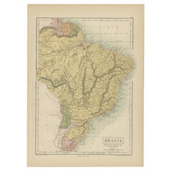
Antique Map of of Brazil, Paraguay and Uruguay
About the Item
Antique map titled 'Bresil Paraguay et Uruguay'. Fine steel engraved map of Brazil, Paraguay and Uruguay. Engraved by Leclercq and published by Armand Aubree in "Atlas Classique et Universel de Geographie Ancienne et Moderne" of Paris in 1837. Engraved by C.V. Monin.
- Dimensions:Height: 19.69 in (50 cm)Width: 12.92 in (32.8 cm)Depth: 0.02 in (0.5 mm)
- Materials and Techniques:
- Period:
- Date of Manufacture:1837
- Condition:Repaired. Wear consistent with age and use. General age-related toning. Shows wear and soiling. Minor foxing. Repair on two small tears in bottom margin. Blank verso. Please study image carefully.
- Seller Location:Langweer, NL
- Reference Number:Seller: BG-13193-11stDibs: LU3054331100032
About the Seller
5.0
Recognized Seller
These prestigious sellers are industry leaders and represent the highest echelon for item quality and design.
Platinum Seller
Premium sellers with a 4.7+ rating and 24-hour response times
Established in 2009
1stDibs seller since 2017
2,412 sales on 1stDibs
Typical response time: 1 hour
- ShippingRetrieving quote...Shipping from: Langweer, Netherlands
- Return Policy
Authenticity Guarantee
In the unlikely event there’s an issue with an item’s authenticity, contact us within 1 year for a full refund. DetailsMoney-Back Guarantee
If your item is not as described, is damaged in transit, or does not arrive, contact us within 7 days for a full refund. Details24-Hour Cancellation
You have a 24-hour grace period in which to reconsider your purchase, with no questions asked.Vetted Professional Sellers
Our world-class sellers must adhere to strict standards for service and quality, maintaining the integrity of our listings.Price-Match Guarantee
If you find that a seller listed the same item for a lower price elsewhere, we’ll match it.Trusted Global Delivery
Our best-in-class carrier network provides specialized shipping options worldwide, including custom delivery.More From This Seller
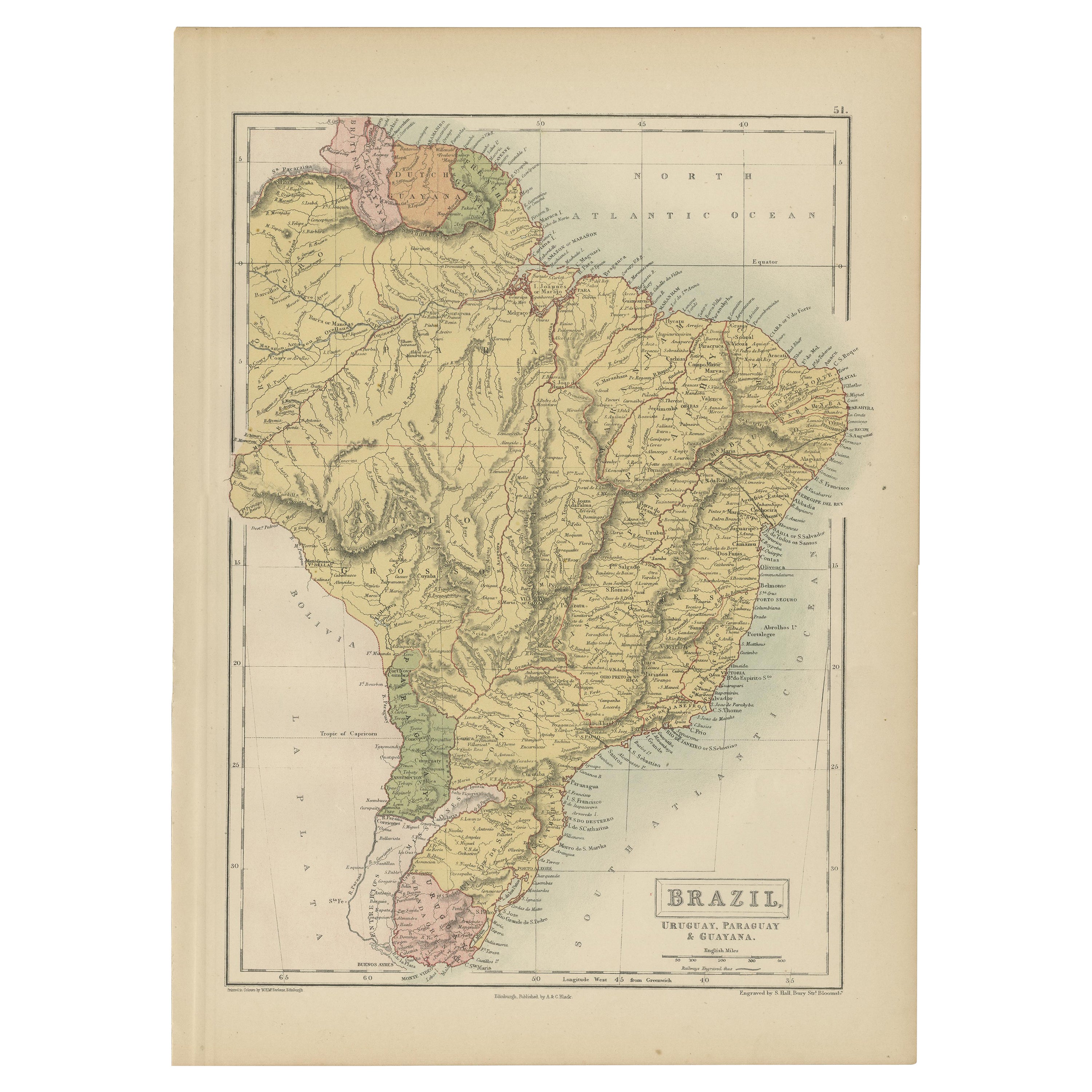
View AllAntique Map of Brazil, Uruguay, Paraguay and Guyana by A & C. Black, 1870
Located in Langweer, NL
Antique map titled 'Brazil'. Original antique map of Brazil, Uruguay, Paraguay and Guyana. This map originates from ‘Black's General Atlas of The...
Category
Antique Late 19th Century Maps
Materials
Paper
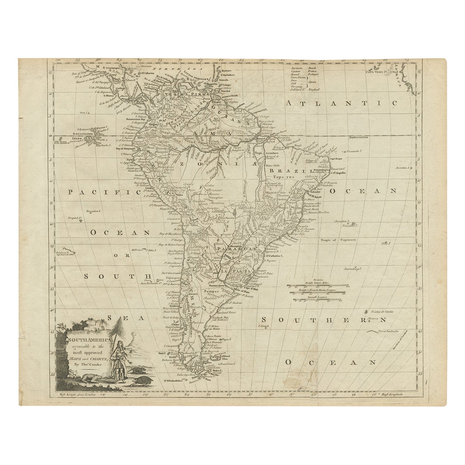
Rare Map of South America of Chili, La Plata, Paraguay, Brazil, Peru, c.1775
Located in Langweer, NL
Antique map titled 'South America agreeable to the most approved maps and charts'.
Rare map of South America depicting Chili, La Plata, Paraguay, Brazil, ...
Category
Antique 1770s Maps
Materials
Paper

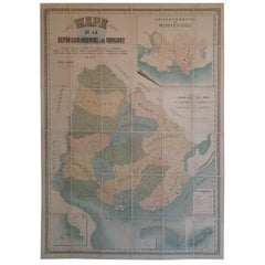
Cortesi's Masterpiece: A Comprehensive and Authoritative Map of Uruguay, 1903
Located in Langweer, NL
Antique map titled 'Mapa de la Republica Oriental del Uruguay'. Large and detailed folding map of Uruguay. This monumental map depicts all of Uruguay with unprecedented accuracy and detail. Impressively, it serves the multiple roles of being an advanced topographic, economic and political map, as well as being a meticulous sea chart of the Rio de la Plata and the adjacent waters of the Atlantic. The republic's 20 departments are defined in various colors, while a legend, 'Referencias' identifies symbols representing the locations of departmental capitals, town, roads, railways, public schools and lighthouses, amongst other details. Every single river and stream is delineated and named and the ridges of hills are delicately expressed. The map features four insets, including a large map of the capital, Montevideo, as well as maps of Colonia, Maldonado and Punta del Este and the Island of Flores. The hydrographical information provided is truly profound, and renders the map fit for use in maritime commerce.
In 1901, the Uruguayan House of Representatives commissioned the geographer Saturnino Cortesi to employ the most progressive geographical sources, both military and civilian, to devise an authoritative national map of the republic. Cortesi clearly had access to a vast archive of topographical surveys...
Category
Early 20th Century Maps
Materials
Paper
$5,107 Sale Price
20% Off
Free Shipping
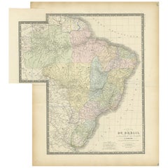
Antique Map of Brazil by Wyld, '1845'
Located in Langweer, NL
Antique map titled 'Empire of Brazil'. Original antique map of Brazil. This map originates from 'An Atlas of the World, Comprehending Separate Ma...
Category
Antique Mid-19th Century Maps
Materials
Paper

Antique Map of Brazil by Levasseur '1875'
Located in Langweer, NL
Antique map titled 'Carte du Brésil'. Large map of Brazil, with small fold out. This map originates from 'Atlas de Géographie Moderne Physique et Politiq...
Category
Antique Late 19th Century Maps
Materials
Paper
$371 Sale Price
20% Off
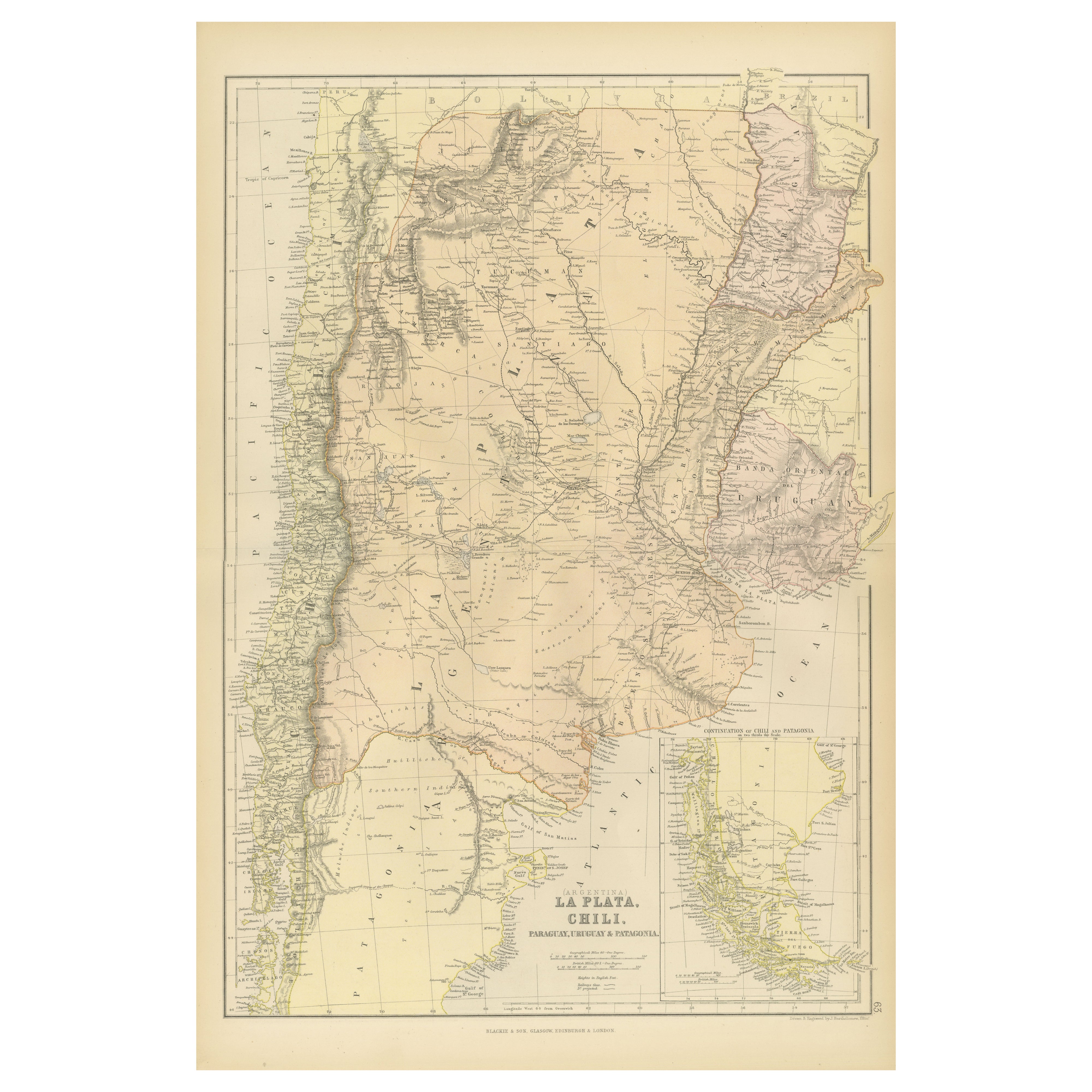
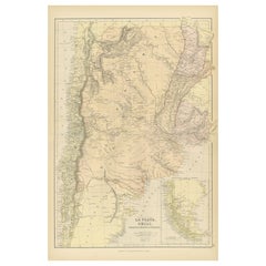
1882 Map of Argentina, La Plata, Chile, Paraguay, Uruguay, and Patagonia
Located in Langweer, NL
This 1882 map, published as part of the 'Comprehensive Atlas and Geography of the World' by Blackie and Son, provides an intricate depiction of Argentina, La Plata, Chile, Paraguay, ...
Category
Antique 1880s Maps
Materials
Paper
You May Also Like
Antique Map of Principality of Monaco
By Antonio Vallardi Editore
Located in Alessandria, Piemonte
ST/619 - "Old Geographical Atlas of Italy - Topographic map of ex-Principality of Monaco" -
ediz Vallardi - Milano -
A somewhat special edition ---
Category
Antique Late 19th Century Italian Other Prints
Materials
Paper

Original Antique Map of Spain and Portugal, circa 1790
Located in St Annes, Lancashire
Super map of Spain and Portugal
Copper plate engraving by A. Bell
Published, circa 1790.
Unframed.
Category
Antique 1790s English Other Maps
Materials
Paper

Original Antique Map of Ireland- Tipperary and Waterford. C.1840
Located in St Annes, Lancashire
Great map of Tipperary and Waterford
Steel engraving
Drawn under the direction of A.Adlard
Published by How and Parsons, C.1840
Unframed.
Category
Antique 1840s English Maps
Materials
Paper

Original Antique Map of United States, Grattan and Gilbert, 1843
Located in St Annes, Lancashire
Great map of United States
Drawn and engraved by Archer
Published by Grattan and Gilbert. 1843
Original colour
Unframed.
Category
Antique 1840s English Maps
Materials
Paper

Original Antique Map of Ireland- Kerry. C.1840
Located in St Annes, Lancashire
Great map of Kerry
Steel engraving
Drawn under the direction of A.Adlard
Published by How and Parsons, C.1840
Unframed.
Category
Antique 1840s English Maps
Materials
Paper

Original Antique Map of South America. C.1780
Located in St Annes, Lancashire
Great map of South America
Copper-plate engraving
Published C.1780
Two small worm holes to left side of map
Unframed.
Category
Antique Early 1800s English Georgian Maps
Materials
Paper

Recently Viewed
View AllMore Ways To Browse
Curved Back Settee Sofa
Danish Tufted Chair
Easy Chair Grey
English Wood Bench
Expandable Glass Tables
Farmhouse Consoles
Figured Walnut Side Table
Flora Fauna Plate
French Louis Xv Bureau Plat
French Metal Chair With Leather Seat
French Round Table With Leaves
Georg Jensen Acorn
German Coffee Pot
Gilt Embroidery
Glass Dining Table And Leather Chairs
Gold Moser Glass
Hand Painted Herend Hungary
Handmade Turkey Decoration