Items Similar to Antique Map of Belgium and Luxembourg by Homann Heirs, 1747


Want more images or videos?
Request additional images or videos from the seller
1 of 5
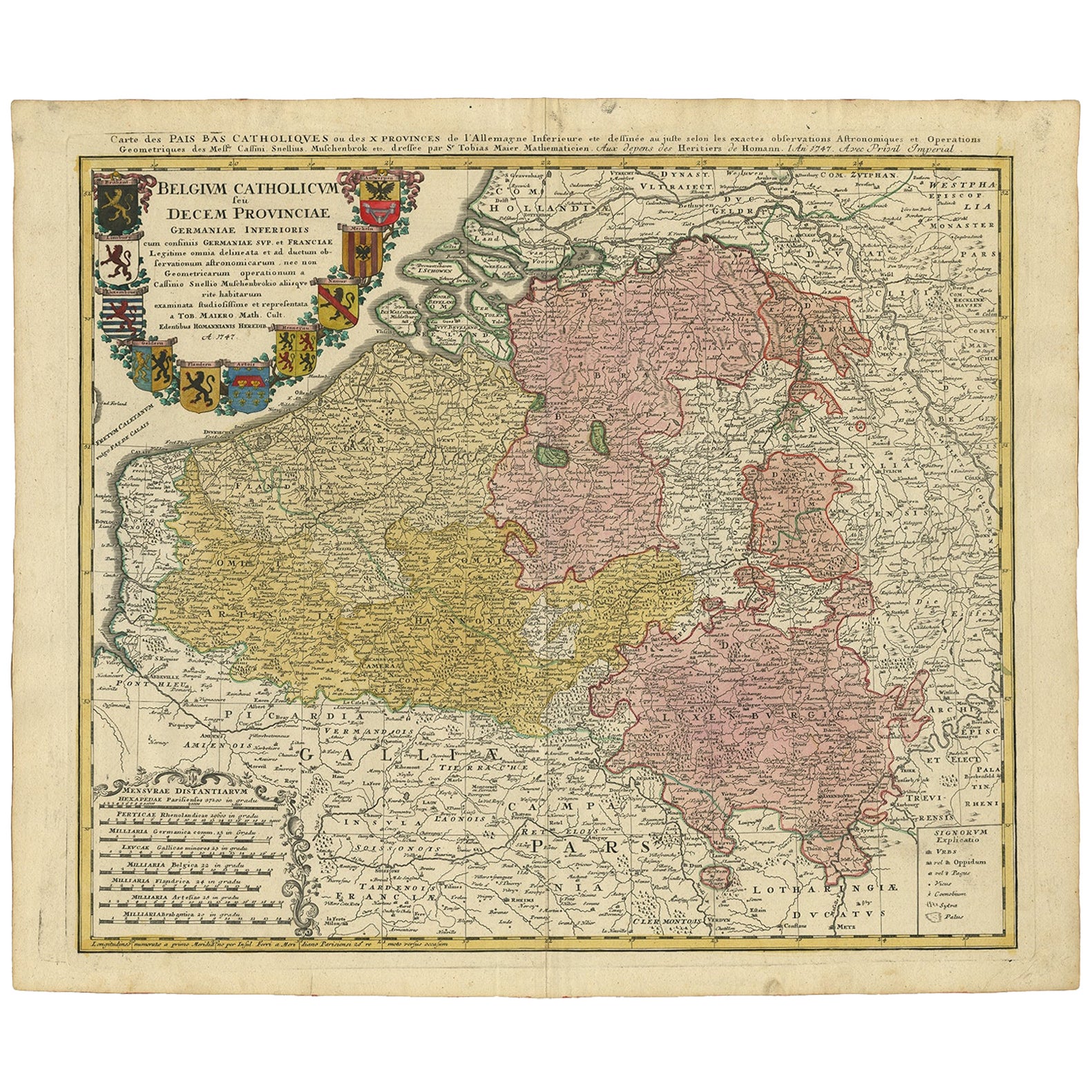
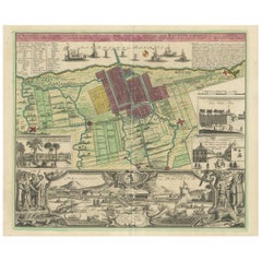
Antique Map of Belgium and Luxembourg by Homann Heirs, 1747
About the Item
Antique map titled 'Belgium Catholicum seu Decem provinciae Germaniae Inferioris cum confiniis Germaniae sup. et Francia (..).' Detailed map of Belgium and Luxembourg showing parts of Holland, France and Germany as well. Includes 10 coats of arms (Brabant, Limburg, Luxembourg, Geldern, Flandern, Artois, Hennegau, Namur, Mechlan, Antwerpen).
Artists and Engravers: Following the long period of Dutch domination, the Homann family became the most important map publishers in Germany in the eighteenth century, the business being founded by J.B. Homann in Nuremberg about the year 1702. Soon after publishing his first atlas in 1707 he became a member of the Berlin academy of Sciences and in 1715 he was appointed Geographer to the Emperor. After the founder's death in 1724, the firm was continued under the direction of his son until 1730 and was then bequeathed to his heirs on the condition that it trades under the name of Homann Heirs. The firm remained in being until the next century and had a wide influence on map publishing in Germany. Apart from the atlases the firm published a very large number of individual maps. The Homanns produced a Neuer Atlas in 1714, a Grosser Atlas in 1737, and an Atlas Maior with about 300 maps in 1780. They also issued a special Atlas of Germany with full sized plans of principal cities, school atlases and an Atlas of Silesia in 1750 with 20 maps.
Condition: Good, general age-related toning. Original folding line, minor wear. Blank verso. Please study imagecarefully.
Date: 1747
Overall size: 62 x 53.5 cm.
Image size: 56 x 49 cm.
We sell original antique maps to collectors, historians, educators and interior decorators all over the world. Our collection includes a wide range of authentic antique maps from the 16th to the 20th centuries. Buying and collecting antique maps is a tradition that goes back hundreds of years. Antique maps have proved a richly rewarding investment over the past decade, thanks to a growing appreciation of their unique historical appeal. Today the decorative qualities of antique maps are widely recognized by interior designers who appreciate their beauty and design flexibility. Depending on the individual map, presentation, and context, a rare or antique map can be modern, traditional, abstract, figurative, serious or whimsical. We offer a wide range of authentic antique maps for any budget.
- Dimensions:Height: 21.07 in (53.5 cm)Width: 24.41 in (62 cm)Depth: 0 in (0.01 mm)
- Materials and Techniques:
- Period:
- Date of Manufacture:1747
- Condition:
- Seller Location:Langweer, NL
- Reference Number:Seller: BG-12419-21stDibs: LU3054326269882
About the Seller
5.0
Recognized Seller
These prestigious sellers are industry leaders and represent the highest echelon for item quality and design.
Platinum Seller
Premium sellers with a 4.7+ rating and 24-hour response times
Established in 2009
1stDibs seller since 2017
2,412 sales on 1stDibs
Typical response time: 1 hour
- ShippingRetrieving quote...Shipping from: Langweer, Netherlands
- Return Policy
Authenticity Guarantee
In the unlikely event there’s an issue with an item’s authenticity, contact us within 1 year for a full refund. DetailsMoney-Back Guarantee
If your item is not as described, is damaged in transit, or does not arrive, contact us within 7 days for a full refund. Details24-Hour Cancellation
You have a 24-hour grace period in which to reconsider your purchase, with no questions asked.Vetted Professional Sellers
Our world-class sellers must adhere to strict standards for service and quality, maintaining the integrity of our listings.Price-Match Guarantee
If you find that a seller listed the same item for a lower price elsewhere, we’ll match it.Trusted Global Delivery
Our best-in-class carrier network provides specialized shipping options worldwide, including custom delivery.More From This Seller
View AllAntique Map of Belgium and Luxembourg by Homann Heirs, 1747
Located in Langweer, NL
Antique map titled 'Belgium Catholicum seu Decem provinciae Germaniae Inferioris cum confiniis Germaniae sup. et Francia (..).' Detailed map of Belgium and Luxembourg showing parts o...
Category
Antique 18th Century Maps
Materials
Paper
Antique Map of Africa by Homann Heirs, '1804'
Located in Langweer, NL
Antique map titled 'Charte von Africa'. Large, original antique map of Africa by Franz Ludwig Güssefeld. Published by Homann Heirs, 1804.
Category
Antique Early 19th Century Maps
Materials
Paper

$1,387 Sale Price
20% Off
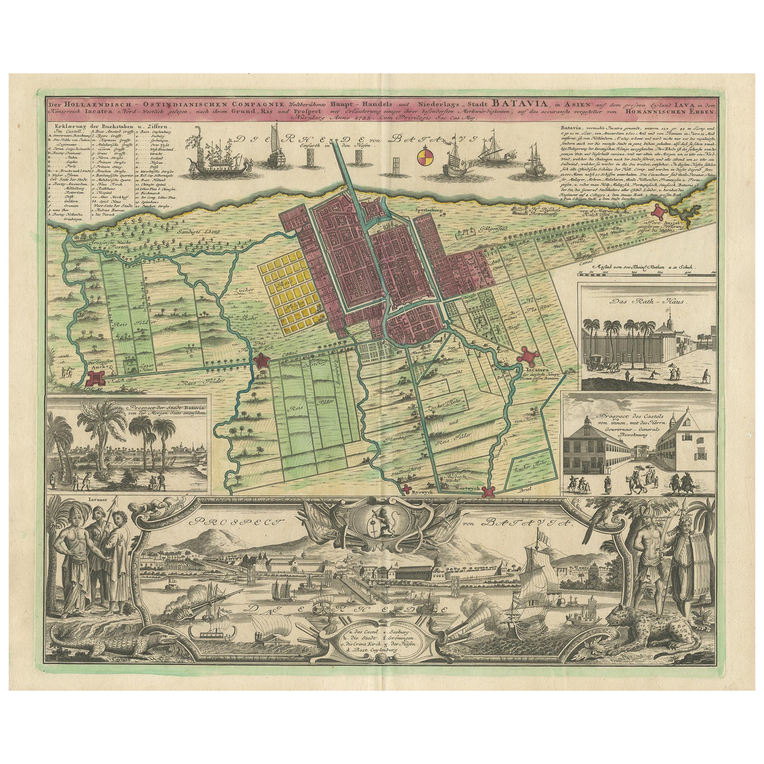
Antique Map and Views of Batavia by Homann Heirs, '1733'
Located in Langweer, NL
Antique map titled 'Der Hollaendisch-Ostindianischen Compagnie weltberuhmte Haupt-Handels und Niederlags-Stadt Batavia, in Asien auf dem grossen Eyland Iava in dem konigreich Iacatra...
Category
Antique Mid-18th Century Maps
Materials
Paper
$2,168 Sale Price
25% Off
Antique Map of Menorca / Minorca by Homann Heirs '1757'
Located in Langweer, NL
Antique map titled 'Carte Topographique de l'Isle Minorque'. Scarce decorative map of Menorca (or Minorca), with two gorgeous views of Mahon and Fort St. Phillipe at the bottom. Publ...
Category
Antique Mid-18th Century Maps
Materials
Paper

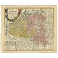
Antique Map of the Seventeen Provinces by Homann Heirs, 1748
By Homann Heirs
Located in Langweer, NL
Antique map titled 'Belgii Universi seu Inferioris Germaniae quam XVII Provinciae (..)'. Map of the Seventeen Provinces after Tobias Meier, published by Homann's Heirs in 1748. The S...
Category
Antique 18th Century Maps
Materials
Paper

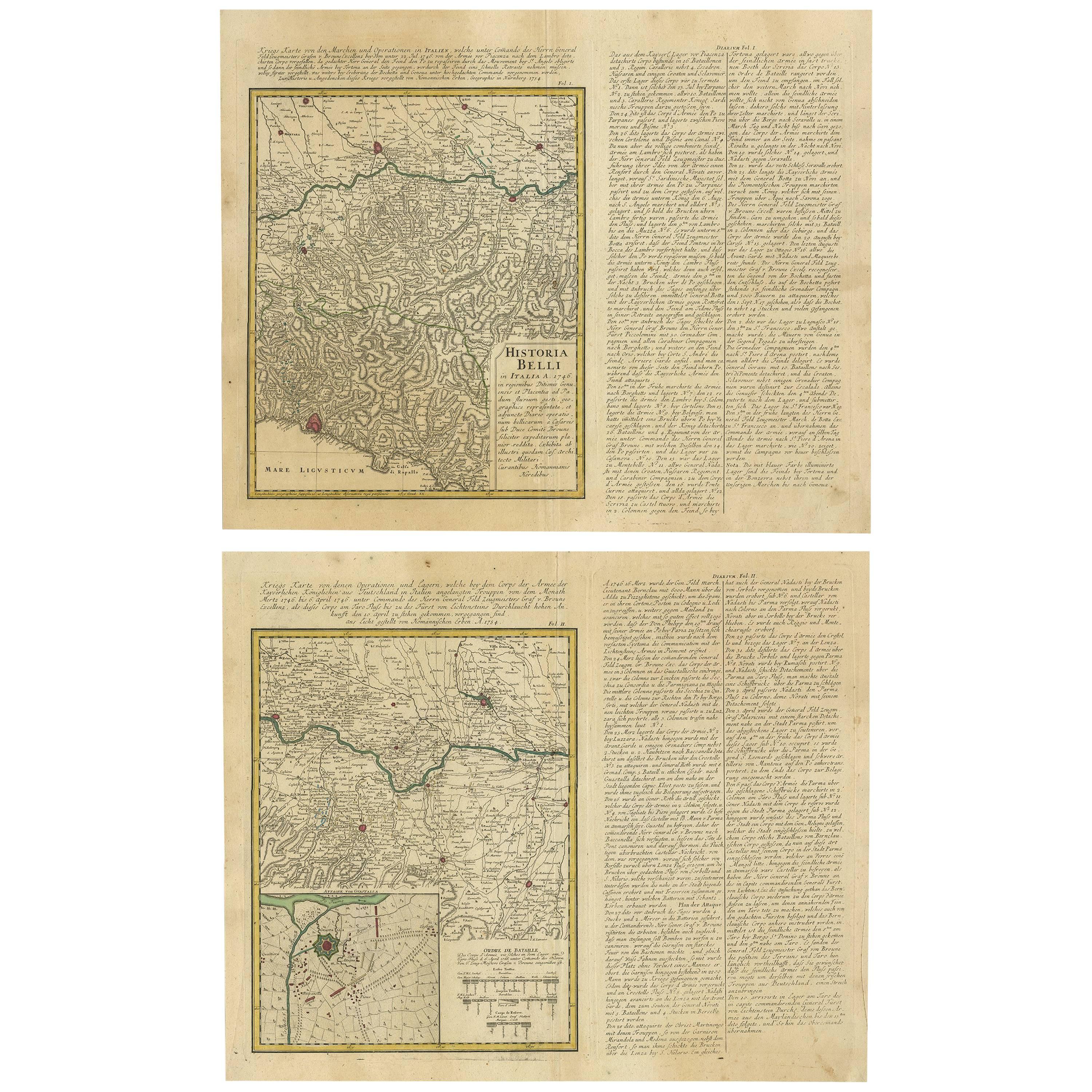
Set of Two Antique Maps of Northern Italy by Homann Heirs, 1754
Located in Langweer, NL
Set of two maps of northern Italy showing the position of troups during the war in April and March 1746. The area covered includes the course of the River Po between Valenza (north of Alexandria) and San Benedetto...
Category
Antique Mid-18th Century Maps
Materials
Paper
$669 Sale Price / set
34% Off
You May Also Like
Sweden & Adjacent Portions of Scandinavia: A Hand-Colored 18th C. Map by Homann
By Johann Baptist Homann
Located in Alamo, CA
This hand-colored map of Sweden and adjacent portions of Scandinavia entitled "Regni Sueciae in Omnes suas Subjacentes Provincias accurate divisi Tabula Generalis" was created by Joh...
Category
Antique 1720s German Maps
Materials
Paper

18th Century Hand-Colored Homann Map of Germany, Including Frankfurt and Berlin
By Johann Baptist Homann
Located in Alamo, CA
An 18th century hand-colored map entitled "Tabula Marchionatus Brandenburgici et Ducatus Pomeraniae quae sunt Pars Septentrionalis Circuli Saxoniae Superioris" by Johann Baptist Homa...
Category
Antique Early 18th Century German Maps
Materials
Paper

Hand Colored 18th Century Homann Map of Austria Including Vienna and the Danube
By Johann Baptist Homann
Located in Alamo, CA
"Archiducatus Austriae inferioris" is a hand colored map of Austria created by Johann Baptist Homann (1663-1724) and published in Nuremberg, Germany in 1728 shortly after his death. ...
Category
Antique Early 18th Century German Maps
Materials
Paper

The Kingdom of Naples and Southern Italy: A Hand-Colored 18th Century Homann Map
By Johann Baptist Homann
Located in Alamo, CA
"Novissima & exactissimus Totius Regni Neapolis Tabula Presentis Belli Satui Accommo Data" is a hand colored map of southern Italy and the ancient Kingdom of Naples created by Johann...
Category
Antique Early 18th Century German Maps
Materials
Paper

Hand-Colored 18th Century Homann Map of the Black Sea, Turkey and Asia Minor
By Johann Baptist Homann
Located in Alamo, CA
An attractive original early 18th century hand-colored map of the Black Sea and Turkey entitled "Carte de L'Asie Minevre ou de la Natolie et du Pont Evxin Tiree des Voyages et des Ob...
Category
Antique Early 18th Century German Maps
Materials
Paper

Hand-Colored 18th Century Homann Map of Denmark and Islands in the Baltic Sea
By Johann Baptist Homann
Located in Alamo, CA
An 18th century copper plate hand-colored map entitled "Insulae Danicae in Mari Balthico Sitae utpote Zeelandia, Fionia, Langelandia, Lalandia, Falstria, Fembria Mona" created by Joh...
Category
Antique Early 18th Century German Maps
Materials
Paper

Recently Viewed
View AllMore Ways To Browse
English Silver Teaspoons
English Teaspoons
Fortuny Patterns
Fragment Side Table
French Aubusson Savonnerie
Fuchsia Rug
German Sofas 1960
Giant Vintage Items
Glass And Brass Dining Table And Chairs
Glass Lucite Coffee Table Base
Glass Topped Matching Side Tables
Hand Carved Octagon Table
Hand Carved Wood Marble Top Side Table
Handmade Shoes
Herman Miller 1960s Eames Chair
Iron Scroll Chair
Italian Bamboo Stools
Italian Bentwood Chairs