Items Similar to Antique Map of Ancient Jerusalem, depicting The Temple of Solomon, c.1725

Want more images or videos?
Request additional images or videos from the seller
1 of 5
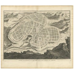
Antique Map of Ancient Jerusalem, depicting The Temple of Solomon, c.1725
About the Item
Antique map titled 'Nieuwe Plattegrond van het Oude Jeruzalem Volgens den Schryver.'
Bird's-eye view of the ancient city of Jerusalem shows its divisions with prominent depictions of the Temple of Solomon and the royal palace and gardens. The map is oriented with west at top, with the Calvary outside the city walls at top right. This plate originates from: 'Het algemeen groot historisch, oordeelkundig, chronologisch, geografisch, en letterlyk naam- en woord-boek, van den gantschen H. Bijbel. Dienende tot de gedenk-stukken der Jooden en andere oudheden, ter opheldering der H. Schrift ... Nu in't Nederduitsch overgezet, merkelyk vermeerdert, en met aanmerkingen verrykt, door Mattheus Gargon.' and it's additons: 'Byvogzel tot het algemeen groot ... Naam- en woord-boek ... En nu in zuiver Nederduitsch overgezet, merkelyk vermeerdert, en metv aanmerkingen verrykt, door Jakob van Ostade en Arn. Henr. Westerhovius.', by Augustines Calmet, published in Leiden, Amsterdam, by Samuel Luchtmans, R. & J. Wetstein en Smith 1725-1731.
This is a reknown encyclopaedic dictionary on all aspects of the history, geography and culture of the Bible and Biblical times. This Dutch translation originates from Calmet's work in French including: 'Commentaire littéral sur tous les livres de l'Ancien et du Nouveau Testament ...', first published in Paris in 1707. Artists and Engravers: Made by 'Antoine Augustin Calmet' after an anonymous artist.
Author: Antoine Augustin Calmet (1672-1757), French Benedictine. Translation by: translation by Mattheus Gargon (1661-1728), a minister in Vlissingen. Engravings in this work by A. de Putter, F. van Bleyswyk, M. Pool, Ph. van Gunst, etc.
Condition: Good, given age. A few minor crinkles. Small hole right margin. Original middle fold as issued. General age-related toning and/or occasional minor defects from handling. Please study image carefully.
Date: c.1725
Overall size: 49.5 x 39.5 cm.
Image size: 43 x 31.5 cm.
- Dimensions:Height: 19.49 in (49.5 cm)Width: 15.56 in (39.5 cm)Depth: 0 in (0.01 mm)
- Materials and Techniques:
- Period:
- Date of Manufacture:circa 1725
- Condition:
- Seller Location:Langweer, NL
- Reference Number:Seller: PCT-614561stDibs: LU3054326393742
About the Seller
5.0
Recognized Seller
These prestigious sellers are industry leaders and represent the highest echelon for item quality and design.
Platinum Seller
Premium sellers with a 4.7+ rating and 24-hour response times
Established in 2009
1stDibs seller since 2017
2,419 sales on 1stDibs
Typical response time: <1 hour
- ShippingRetrieving quote...Shipping from: Langweer, Netherlands
- Return Policy
Authenticity Guarantee
In the unlikely event there’s an issue with an item’s authenticity, contact us within 1 year for a full refund. DetailsMoney-Back Guarantee
If your item is not as described, is damaged in transit, or does not arrive, contact us within 7 days for a full refund. Details24-Hour Cancellation
You have a 24-hour grace period in which to reconsider your purchase, with no questions asked.Vetted Professional Sellers
Our world-class sellers must adhere to strict standards for service and quality, maintaining the integrity of our listings.Price-Match Guarantee
If you find that a seller listed the same item for a lower price elsewhere, we’ll match it.Trusted Global Delivery
Our best-in-class carrier network provides specialized shipping options worldwide, including custom delivery.More From This Seller
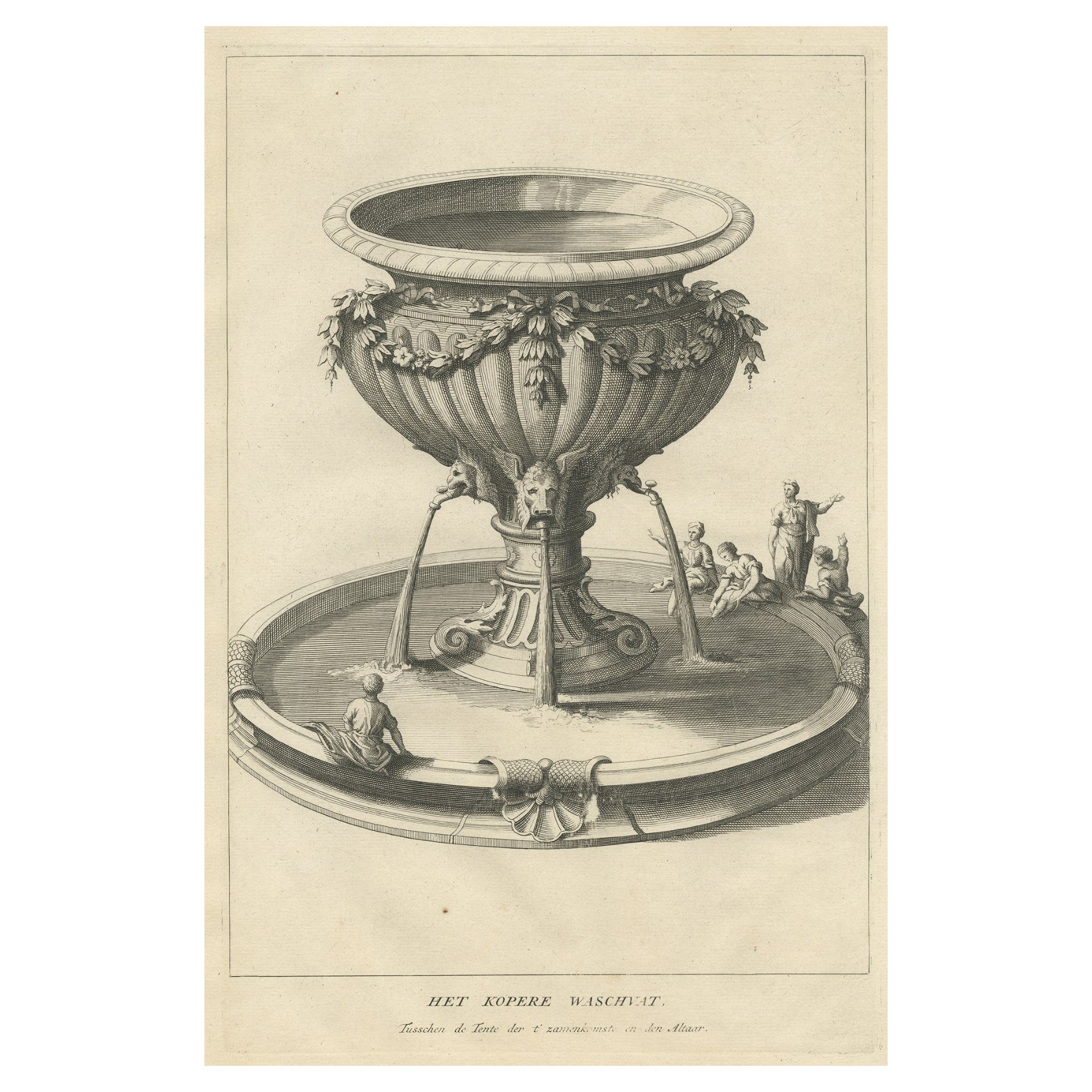
View AllAntique Engraving of the Brass Laver in Solomon's Temple, Jerusalem, ca.1725
Located in Langweer, NL
Antique religion print titled 'Het kopere Waschvat, Tusschen de Tente der t'zamenkomst en den altaar'.
Antique print of the Brass Laver in Solomon's Tem...
Category
Antique 1720s Prints
Materials
Paper
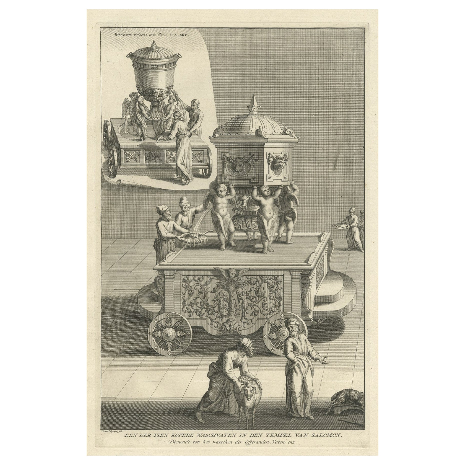
Antique Engraving of One of the Ten Brass Lavers in Solomon's Temple, 1725
Located in Langweer, NL
Antique religion print titled 'Een der tien Kopere Waschvaten in den Tempel van Salomon'.
This print depicts one of the ten Brass Lavers in Solomon's Temple. This print originate...
Category
Antique 1720s Prints
Materials
Paper
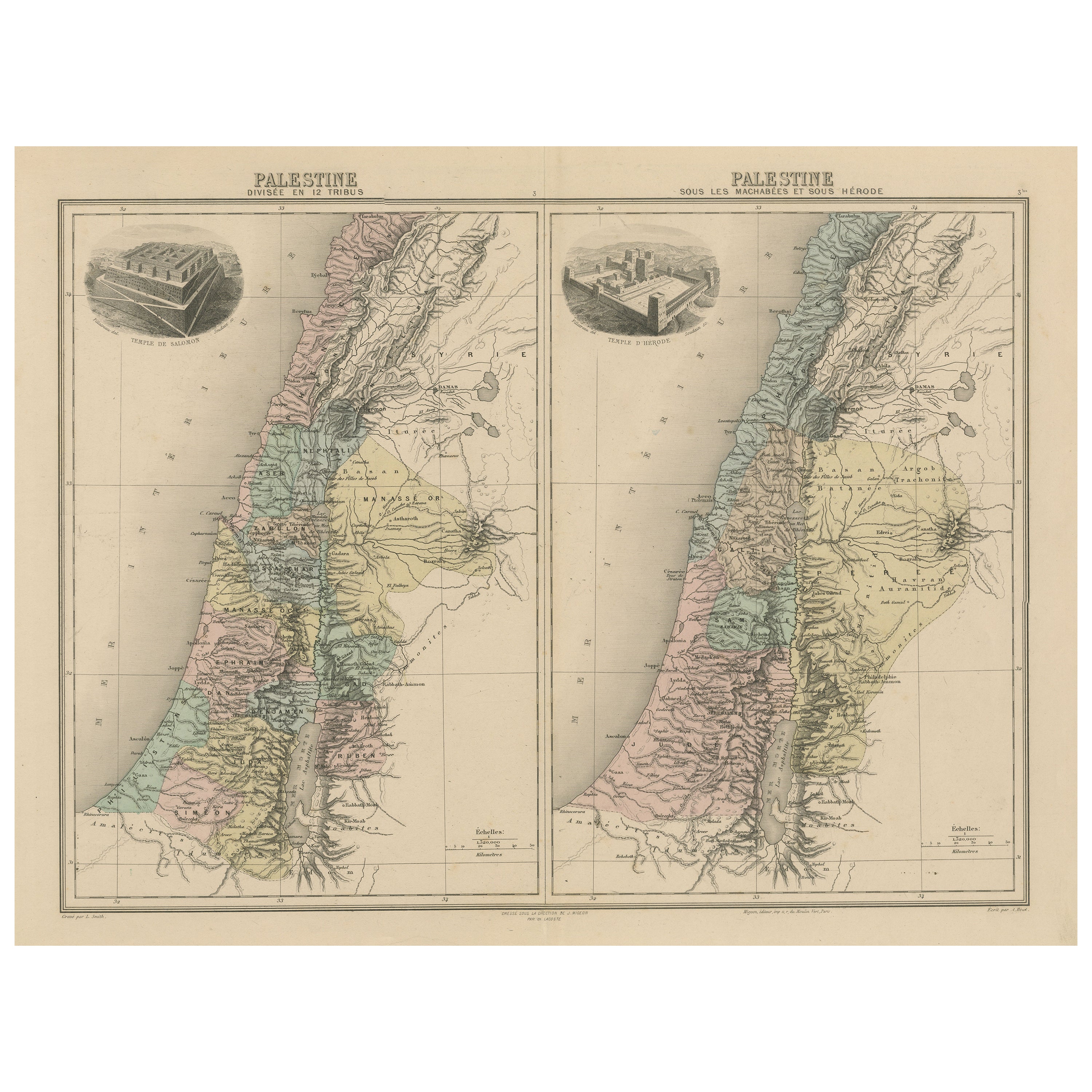
Antique Map of Palestine with Vignettes of the Temples of Solomon and Herodotus
Located in Langweer, NL
Two maps on one sheet titled 'Palestine divisée en 12 Tribus' and 'Palestine sous les Machabées et sous Hérode'. Maps of Palestine, with vignettes of temples of Solomon and Herodotus...
Category
Antique Late 19th Century Maps
Materials
Paper
Antique Map of the Ancient City of Jerusalem by A. Calmet, 1725
Located in Langweer, NL
Antique map, titled: 'Nieuwe Plattegrond van het Oude Jeruzalem Volgens den Schryver.' - Bird's-eye view of the ancient city of Jerusalem shows its divisions with prominent depiction...
Category
Antique Early 18th Century Prints
Materials
Paper
The 'Brazen Sea' in Solomon's Temple and a Cross Section of the Brazen Sea, 1725
Located in Langweer, NL
Two religious images on one sheet titled 'Kopere Zee in den Tempel van Salomon' and 'Doorsnede van de Kopere Zee des Tempels van Salomon'.
The 'Brazen Sea' in Solomon's Temple an...
Category
Antique 1720s Prints
Materials
Paper
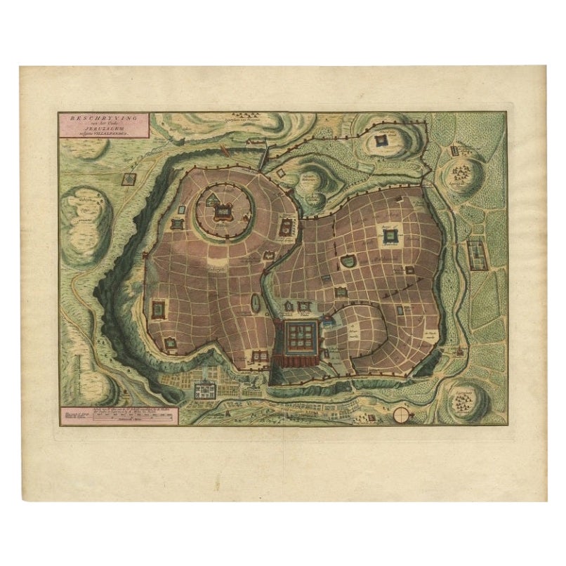
Bird's Eye Plan of the Ancient City of Jerusalem Based on Old Records, c.1725
Located in Langweer, NL
Antique map titled 'Beschryving van het oude Jeruzalem volgens Villalpandus.'
Bird's eye plan of the ancient city of Jerusalem based on Villalpando's foundation map. The plan shows...
Category
Antique 18th Century Maps
Materials
Paper

You May Also Like
French topographic embossed map in three dimensions of ancient Jerusalem - 19th
Located in Bruxelles, BE
French topographic embossed map in three dimensions of Ancient Jerusalem
19th century
wood and hand-coloured plaster
10,5 x 43 x 58 cm
Provenance : Private collection UK
Wood and ...
Category
Antique 19th Century French Belle Époque Models and Miniatures
Materials
Plaster, Wood
1812 United States Map, by Pierre Tardieu, Antique French Map Depicting the U.S.
By Pierre François Tardieu
Located in Colorado Springs, CO
1812 "United States of Nth America -- Carte des Etats-Unis De L'Amerique Septentrionale" Two-Sheet Map by Tardieu
This attractive map, published in Paris in 1812, is one of the most rare large format maps from the period. It features a view of the East Coast of the U.S. from Maryland to just below South Carolina. Additionally, Ellicott’s plan for the City of Washington D.C. is included at the top right and an illustration of Niagara Falls is shown at the bottom right with a description in both French and English. This extremely detailed map not only depicts the mountainous regions of the southeastern U.S., but also includes names of regions, rivers, and towns.
Based on the first state of Arrowsmith’s 4-sheet map of the United States, this map is completely engraved by Tardieu in Paris and showcases high quality engravings. This detailed map of the recently independent United States includes one of the largest and earliest examples of the Ellicott plan of Washington DC.
The artist, Pierre François Tardieu (PF Tardieu) was a very well-known map engraver, geographer, and illustrator. Awarded a bronze medal by King Louis-Phillipe for the accuracy and beauty of his map-making, Tardieu produced many fine works including maps of Louisiana...
Category
Antique 1810s French Maps
Materials
Paper

Original Antique Map of Ancient Greece- Boeotia, Thebes, 1787
Located in St Annes, Lancashire
Great map of Ancient Greece. Showing the region of Boeotia, including Thebes
Drawn by J.D. Barbie Du Bocage
Copper plate engraving by P.F T...
Category
Antique 1780s French Other Maps
Materials
Paper

Original Antique Map of Ancient Greece, Achaia, Corinth, 1786
Located in St Annes, Lancashire
Great map of Ancient Greece. Showing the region of Thessaly, including Mount Olympus
Drawn by J.D. Barbie Du Bocage
Copper plate engraving by P.F Tardieu
Original hand color...
Category
Antique 1780s French Other Maps
Materials
Paper

Russian Silver Icon Depicting Christ Entering Jerusalem
Located in London, GB
Of rectangular shape, the silver moulded to depict the iconic Biblical scene.
This exquisite Russian silver icon, depicting the famous moment of...
Category
Antique Late 19th Century Russian Decorative Art
Materials
Silver
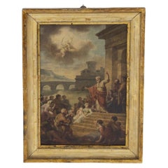
Antique Canvas Depicting 'The Preaching of St. Peter'
Located in Milano, IT
Beautiful framed wooden canvas from the end of the 19th century.
The reference narrative is the one found in the Acts of the Apostles (Acts 2:14-42) in which Saint Peter starts pre...
Category
Antique Early 1900s Italian Romantic Paintings
Materials
Canvas, Wood
$6,041 Sale Price
20% Off
Recently Viewed
View AllMore Ways To Browse
Van Groot
Ancient Bible
Antique Putters
Small Pedestal Tables
Smoked Tempered Glass Table
Spanish Armchair Leather Wood
Sterling Silver Oyster
Swirl Side Table
Swiss Aluminum Chairs
Thick Glass Top Console Table
Thonet Plywood
Tripod Side Table Pair
Used Cloud Couch
Victorian Novelty
Victorian Side Table With Drawers
Vintage Ashtrays 1940s
Vintage French Zinc
Vintage Glasses In Caddy