Items Similar to Antique Map of Africa and Arabia with Inset Map of Ethiopia and Eritrea, 1845


Want more images or videos?
Request additional images or videos from the seller
1 of 5
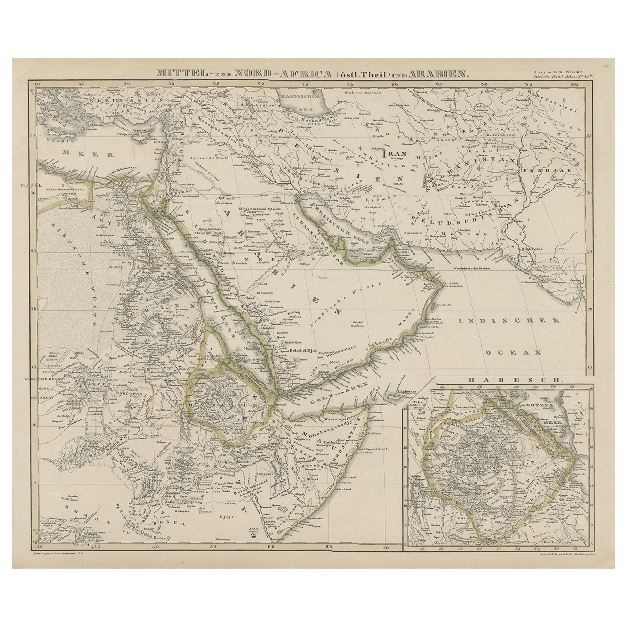
Antique Map of Africa and Arabia with Inset Map of Ethiopia and Eritrea, 1845
About the Item
Antique map titled 'Mittel- und Nord-Africa (östl. Theil) und Arabien'. This map depicts North and Central Africa and Arabia with an inset map of Habesch (Ethiopia and Eritrea).
Artists and Engravers: Engraved by Fr. v. Stülpnagel. Published by A. Stieler in 'Stieler's Hand-Atlas'.
Condition: Very good, general age-related toning. Please study image carefully.
Date: 1845
Overall size: 44 x 36 cm.
Image size: 38.5 x 33 cm.
We sell original antique maps to collectors, historians, educators and interior decorators all over the world. Our collection includes a wide range of authentic antique maps from the 16th to the 20th centuries. Buying and collecting antique maps is a tradition that goes back hundreds of years. Antique maps have proved a richly rewarding investment over the past decade, thanks to a growing appreciation of their unique historical appeal. Today the decorative qualities of antique maps are widely recognized by interior designers who appreciate their beauty and design flexibility. Depending on the individual map, presentation, and context, a rare or antique map can be modern, traditional, abstract, figurative, serious or whimsical. We offer a wide range of authentic antique maps for any budget.
- Dimensions:Height: 14.18 in (36 cm)Width: 17.33 in (44 cm)Depth: 0 in (0.01 mm)
- Materials and Techniques:
- Period:
- Date of Manufacture:1845
- Condition:Condition: Very good, general age-related toning. Please study image carefully.
- Seller Location:Langweer, NL
- Reference Number:Seller: BG-067551stDibs: LU3054325991892
About the Seller
5.0
Recognized Seller
These prestigious sellers are industry leaders and represent the highest echelon for item quality and design.
Platinum Seller
Premium sellers with a 4.7+ rating and 24-hour response times
Established in 2009
1stDibs seller since 2017
2,412 sales on 1stDibs
Typical response time: 1 hour
- ShippingRetrieving quote...Shipping from: Langweer, Netherlands
- Return Policy
Authenticity Guarantee
In the unlikely event there’s an issue with an item’s authenticity, contact us within 1 year for a full refund. DetailsMoney-Back Guarantee
If your item is not as described, is damaged in transit, or does not arrive, contact us within 7 days for a full refund. Details24-Hour Cancellation
You have a 24-hour grace period in which to reconsider your purchase, with no questions asked.Vetted Professional Sellers
Our world-class sellers must adhere to strict standards for service and quality, maintaining the integrity of our listings.Price-Match Guarantee
If you find that a seller listed the same item for a lower price elsewhere, we’ll match it.Trusted Global Delivery
Our best-in-class carrier network provides specialized shipping options worldwide, including custom delivery.More From This Seller
View AllNorth & Central Africa & Arabia, Inset Map of Habesch 'Ethiopia & Eritrea', 1845
Located in Langweer, NL
Antique map titled 'Mittel- und Nord-Africa (östl. Theil) und Arabien'.
This map depicts North and Central Africa and Arabia with an inset map of Habesch (Ethiopia and Eritrea).
...
Category
Antique 1840s Maps
Materials
Paper
Antique Map of South Africa by Wyld '1845'
Located in Langweer, NL
Antique map titled 'South Africa'. Original antique map of South Africa.
This decorative original old map originates from 'An Atlas of th...
Category
Antique Mid-19th Century Maps
Materials
Paper

$185 Sale Price
20% Off
Antique Map of Afghanistan and Surroundings, '1845'
Located in Langweer, NL
Antique map titled 'Map of Persia and Caubul'. Original antique map of Afghanistan and surroundings.
This map originates from 'An Atlas of the World, Comprehending Separate Maps of...
Category
Antique Mid-19th Century Maps
Materials
Paper

$185 Sale Price
20% Off
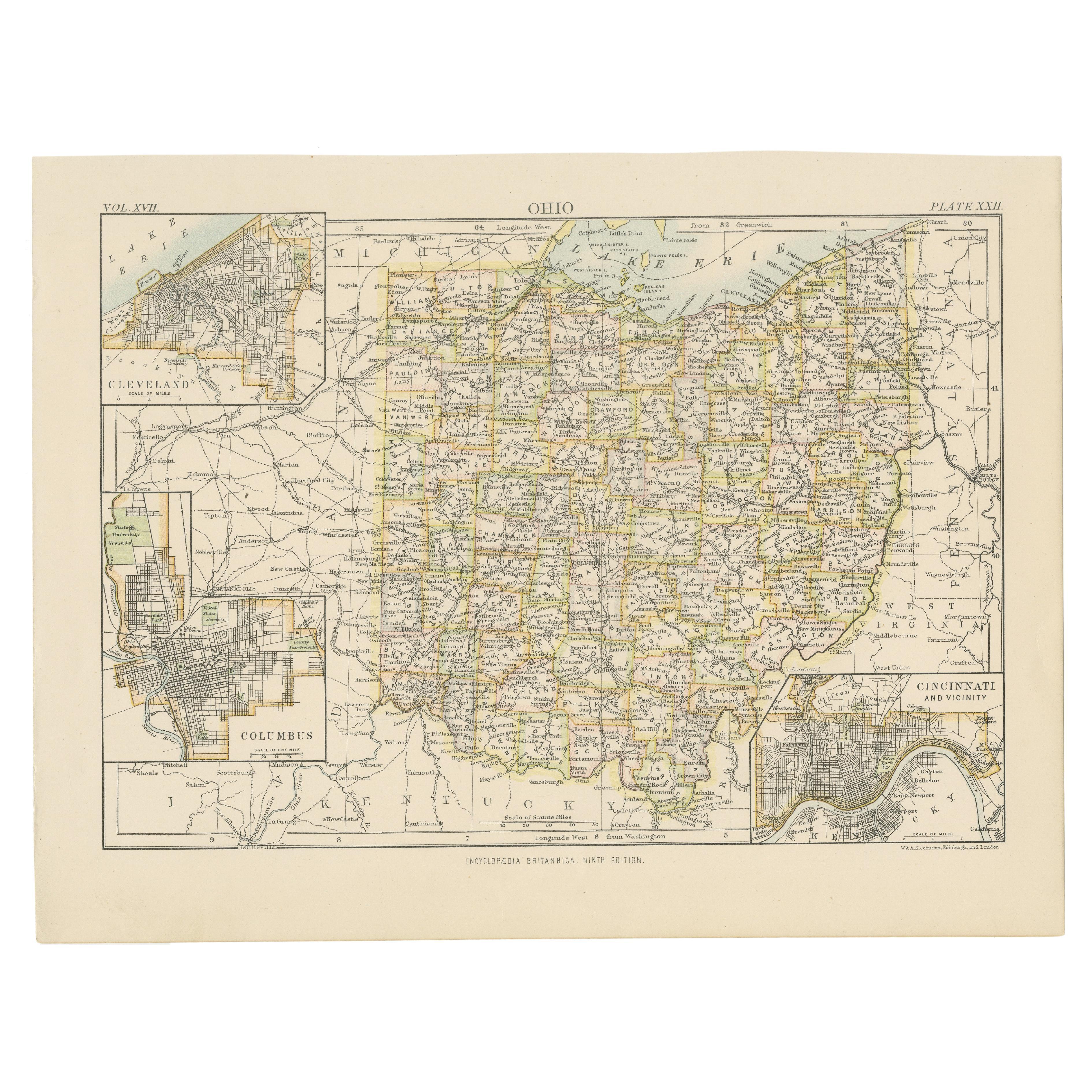
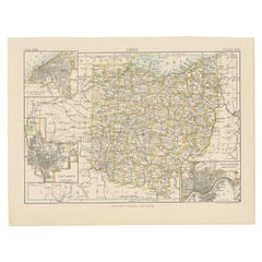
Antique Map of Ohio, with Inset Maps of Cleveland, Columbus and Cincinnati
Located in Langweer, NL
Antique map titled 'Ohio'. Original antique map of Ohio, United States. With inset maps of Cleveland, Columbus and Cincinnati. This print originates from 'Encyclopaedia Britannica', ...
Category
Antique Late 19th Century Maps
Materials
Paper
Antique Map of Wisconsin with Inset Geological Map of Wisconsin
Located in Langweer, NL
Antique map titled 'Wisconsin'. Original antique map of Wisconsin, United States. With inset geological map of Wisconsin. This print originates from '...
Category
Antique Late 19th Century Maps
Materials
Paper

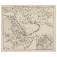
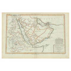
Old Map of the Arabian Peninsula with Parts of Egypt, Sudan, Eritrea & Ethiopia
Located in Langweer, NL
"Carte de l'Arabie, du Golfe Persique, et de la Mer Rouge, avec l'Egypte, la Nubie et l'Abissinie", Bonne, Rigobert
Subject: Arabia
Period: 1780 (circa)
Publication: Atlas de Toutes...
Category
Antique 1780s Maps
Materials
Paper
You May Also Like
Original Antique Map of South Africa, Arrowsmith, 1820
Located in St Annes, Lancashire
Great map of South Africa.
Drawn under the direction of Arrowsmith.
Copper-plate engraving.
Published by Longman, Hurst, Rees, Orme and Br...
Category
Antique 1820s English Maps
Materials
Paper

Antique Map of Principality of Monaco
By Antonio Vallardi Editore
Located in Alessandria, Piemonte
ST/619 - "Old Geographical Atlas of Italy - Topographic map of ex-Principality of Monaco" -
ediz Vallardi - Milano -
A somewhat special edition ---
Category
Antique Late 19th Century Italian Other Prints
Materials
Paper

Original Antique Map of Spain and Portugal, circa 1790
Located in St Annes, Lancashire
Super map of Spain and Portugal
Copper plate engraving by A. Bell
Published, circa 1790.
Unframed.
Category
Antique 1790s English Other Maps
Materials
Paper

Original Antique Map of Ireland- Tipperary and Waterford. C.1840
Located in St Annes, Lancashire
Great map of Tipperary and Waterford
Steel engraving
Drawn under the direction of A.Adlard
Published by How and Parsons, C.1840
Unframed.
Category
Antique 1840s English Maps
Materials
Paper

Original Antique Map of United States, Grattan and Gilbert, 1843
Located in St Annes, Lancashire
Great map of United States
Drawn and engraved by Archer
Published by Grattan and Gilbert. 1843
Original colour
Unframed.
Category
Antique 1840s English Maps
Materials
Paper

"Nova Barbariae Descriptio", a 17th Century Hand-Colored Map of North Africa
By Johannes Janssonius
Located in Alamo, CA
This original attractive 17th century hand-colored map of North Africa entitled "Nova Barbariae Descriptio" by Johannes Janssonius was published in Paris in 1635. It includes the Med...
Category
Antique Mid-17th Century Dutch Maps
Materials
Paper

Recently Viewed
View AllMore Ways To Browse
Antique Map Of Liverpool
Kansas Missouri Map
Lancashire Map
Orinoco Furniture
Rand Mcnally Vintage Maps
Victorian Lea
William Dampier
Art From Lake Superior Region
Astrology Map
J Schwabe
Mauritius Antique Map
Tanzania Antique Map
Tartaria Map
Antique Map Puzzle
Georgetown Map
Johann Baptist Homann On Sale
John Wyld
North Carolina Native Americans 1800