Items Similar to Antique Map of the 1591 Siege and Occupation of Deventer City, Holland, c1610

Want more images or videos?
Request additional images or videos from the seller
1 of 6
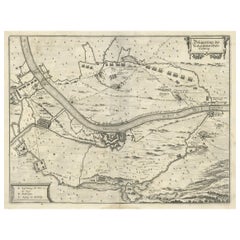
Antique Map of the 1591 Siege and Occupation of Deventer City, Holland, c1610
About the Item
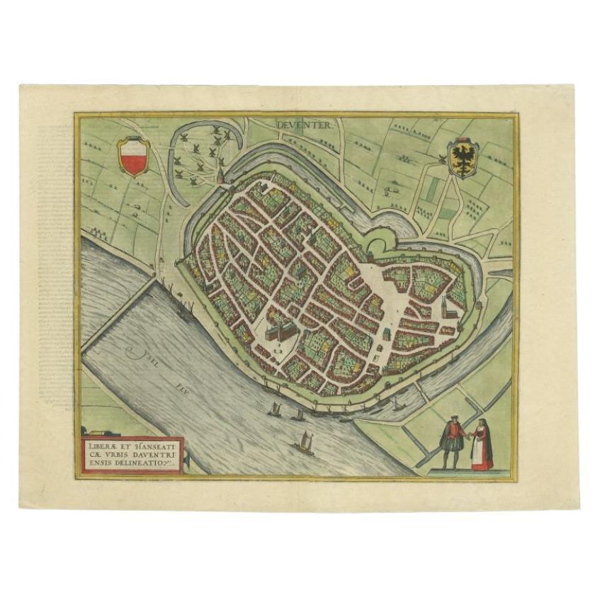
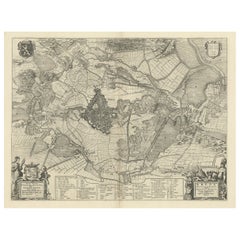
Antique map titled 'Daventria'. Old map of the city of Deventer, the Netherlands. The print illustrates the siege and occupation of Deventer by the State army under command of prince Maurits on 10 June 1591. It shows the city of Deventer and the surrounding land with walls and ramparts. With two pontoon bridges over the IJssel river. This map originates from 'Den Nassauschen Lauren-Crans: Beschrijvinghe ende af-beeldinge van alle de victorien' by Jan Jansz. Orlers en Hendrik van Haestens.
Artists and Engravers: Jan Janszoon Orlers (1570 - 1646), Dutch historian.
Condition: Good, general age-related toning. Some soiling, please study image carefully.
Date: 1610
Overall size: 37.5 x 31 cm.
Image size: 31 x 22 cm.
- Dimensions:Height: 12.21 in (31 cm)Width: 14.77 in (37.5 cm)Depth: 0 in (0.01 mm)
- Materials and Techniques:
- Period:
- Date of Manufacture:1610
- Condition:
- Seller Location:Langweer, NL
- Reference Number:Seller: BG-003831stDibs: LU3054326159982
About the Seller
5.0
Recognized Seller
These prestigious sellers are industry leaders and represent the highest echelon for item quality and design.
Platinum Seller
Premium sellers with a 4.7+ rating and 24-hour response times
Established in 2009
1stDibs seller since 2017
2,419 sales on 1stDibs
Typical response time: <1 hour
- ShippingRetrieving quote...Shipping from: Langweer, Netherlands
- Return Policy
Authenticity Guarantee
In the unlikely event there’s an issue with an item’s authenticity, contact us within 1 year for a full refund. DetailsMoney-Back Guarantee
If your item is not as described, is damaged in transit, or does not arrive, contact us within 7 days for a full refund. Details24-Hour Cancellation
You have a 24-hour grace period in which to reconsider your purchase, with no questions asked.Vetted Professional Sellers
Our world-class sellers must adhere to strict standards for service and quality, maintaining the integrity of our listings.Price-Match Guarantee
If you find that a seller listed the same item for a lower price elsewhere, we’ll match it.Trusted Global Delivery
Our best-in-class carrier network provides specialized shipping options worldwide, including custom delivery.More From This Seller
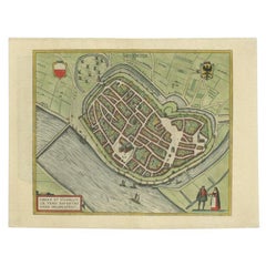
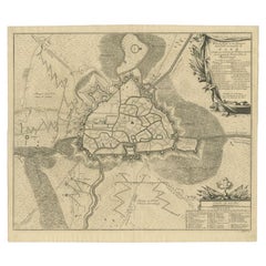
View AllAntique Original Map of the City of Deventer, the Netherlands, 1588
Located in Langweer, NL
Antique map titled 'Liberae et Hanseaticae urbis Daventriensis delineatio'.
Original bird's eye plan of the Dutch hanseatic city Deventer, on the situated IJssel river. This map ...
Category
Antique 16th Century Maps
Materials
Paper
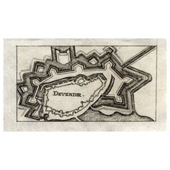
Antique Map of Deventer in the Netherlands, 1691
Located in Langweer, NL
Plate 'Devendr.' (Plan of the fortified city of Deventer, The Netherlands.) This attractive original old antique print / plate originates from: 'Aus...
Category
Antique 17th Century Maps
Materials
Paper
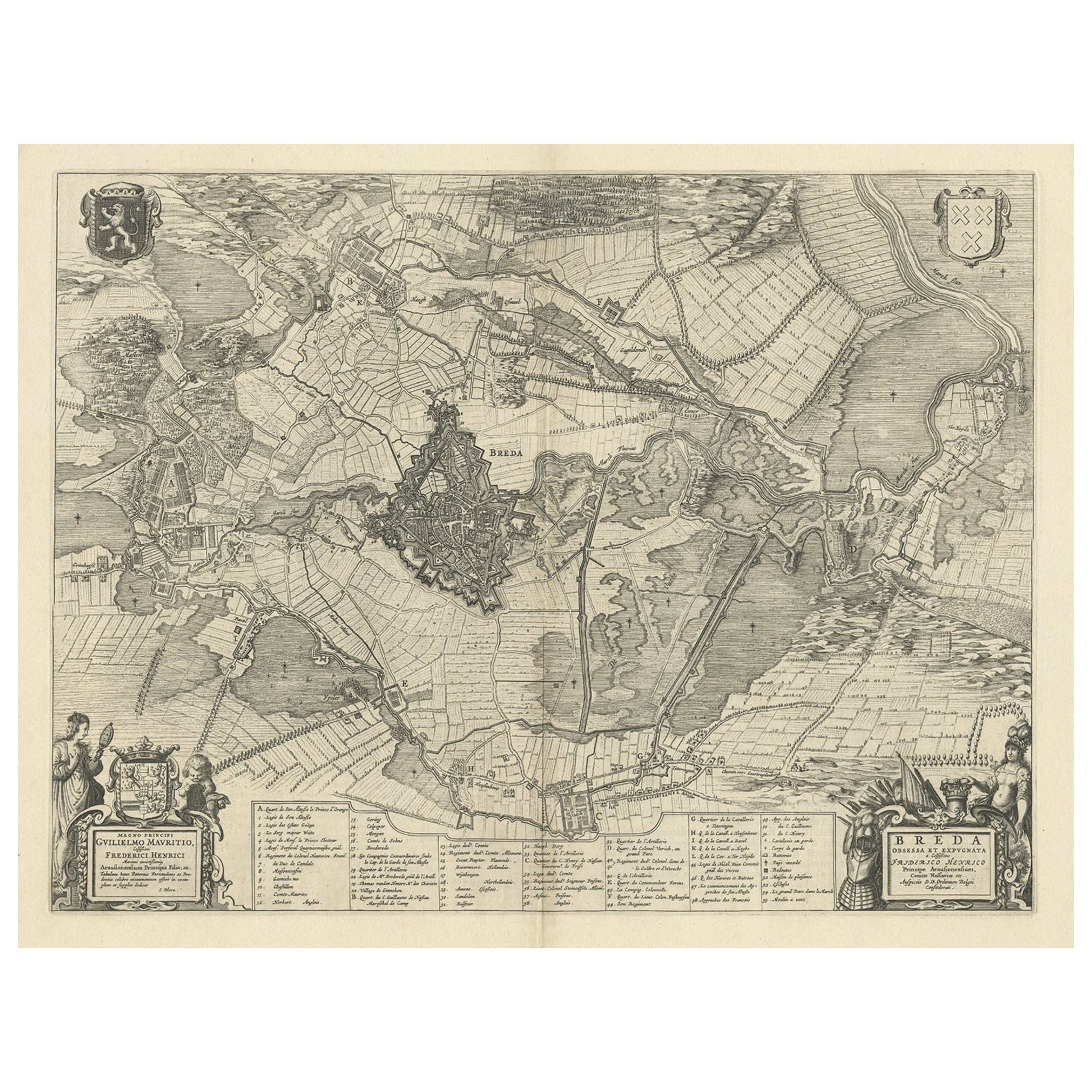
Antique Map of the Siege of Breda, City in the Netherlands by Blaeu, 1649
Located in Langweer, NL
Antique map titled 'Breda obsessa et expugnata a Celsissimo Frederico Henrico'.
Old map of the city of Breda, the Netherlands. It shows the Siege of Breda in 1637. Originates fro...
Category
Antique 17th Century Maps
Materials
Paper
$731 Sale Price
25% Off
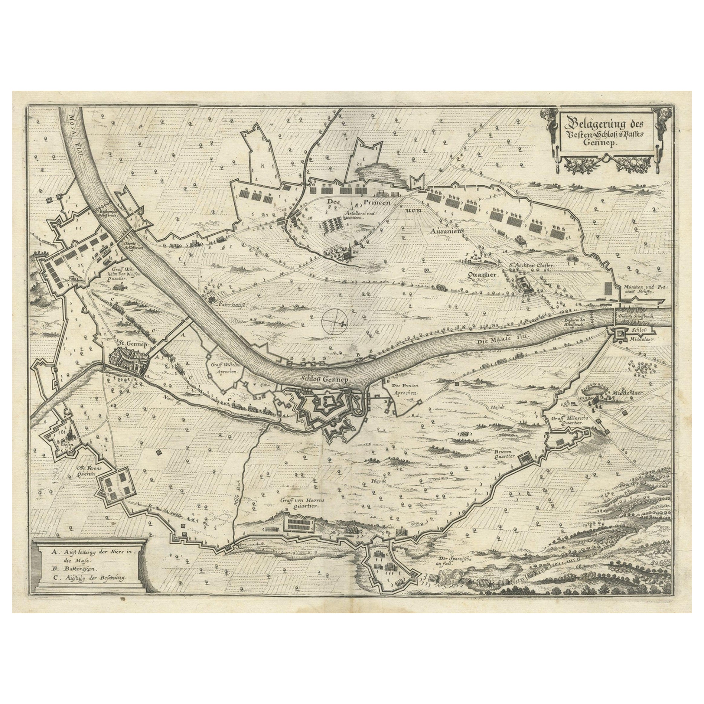
Antique Map of The Siege of Gennep, the Netherlands, c.1650
Located in Langweer, NL
Antique map titled 'Belagerung des Besten Schloss und Passes Gennep'. Old map of the Siege of Gennep, the Netherlands. This map originates from 'Theatrum Europaeum' by M. Merian. Art...
Category
Antique 17th Century Maps
Materials
Paper
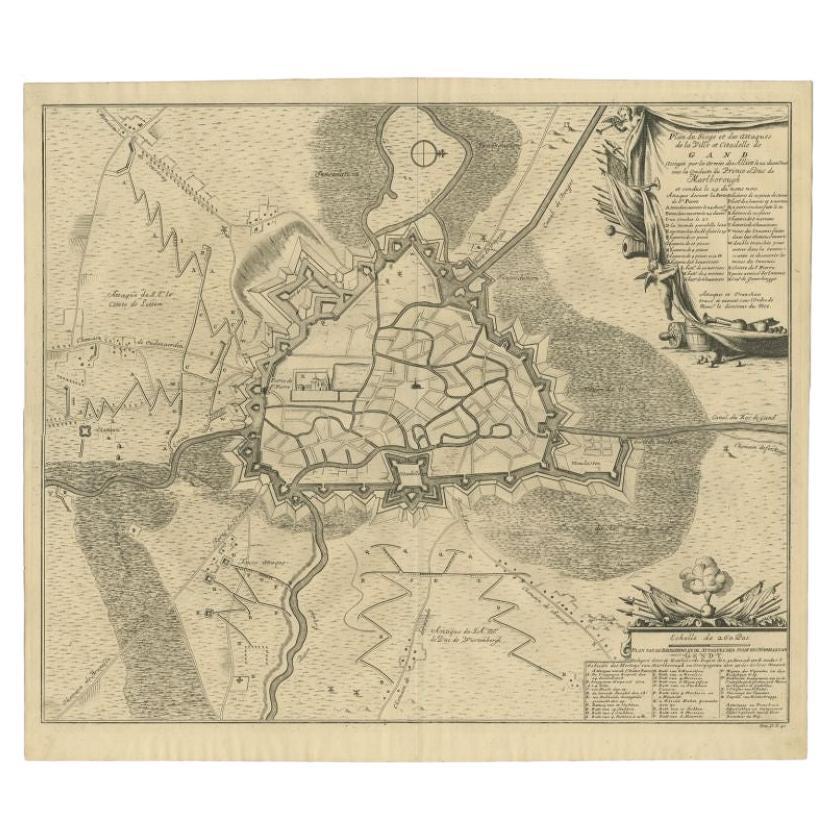
Antique Map of the Siege of Gent by Dumont, 1729
By Dumont
Located in Langweer, NL
Antique map titled 'Plan of the Siege and Attacks of the City and Citadel of Ghent'. Large map depicting the siege of the Belgian city of Gent in 1708 during the war of the Spanish S...
Category
Antique 18th Century Maps
Materials
Paper
$311 Sale Price
20% Off
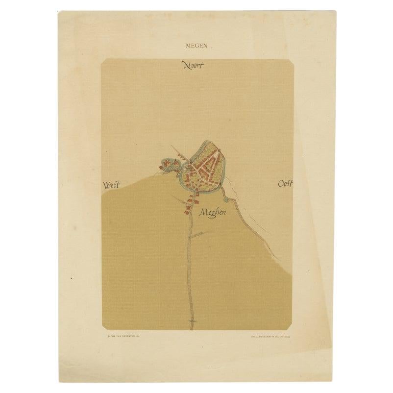
Old Map of the Dutch City of Megen in Holland, 1916
Located in Langweer, NL
Antique map Megen titled 'Megen'. Antique map depicting the city of Megen, Noord-Brabant, The Netherlands.
Artists and Engravers: Lithograph by J. Smulders & Co, Den Haag.
Con...
Category
20th Century Maps
Materials
Paper

You May Also Like
17th Century John Speed Map of Denbighshire, c.1610
By John Speed
Located in Royal Tunbridge Wells, Kent
Antique early 17th century British very rare and original John Speed, hand coloured map of Denbighshire, dated 1610, by John Sunbury and George Humble. John...
Category
Antique 17th Century British Maps
Materials
Wood, Paper

Antique Map of American Cities, Vignette of New York City, circa 1920
Located in St Annes, Lancashire
Great maps of American Cities
Unframed
Original color
By John Bartholomew and Co. Edinburgh Geographical Institute
Published, circa 1920
Category
Vintage 1920s British Maps
Materials
Paper

Italian Parchment Map of the City of Pisa Dated, 1640
By Matthäus Merian the Elder
Located in Florence, Tuscany
An antique map of the Tuscan city of Pisa engraved for The 'Itinerarium Italiæ Nov-antiquæ' by Matthäus Merian the Elder and printed in 1640....
Category
Antique 1640s Italian Maps
Materials
Paper

1840 Map of the City of Washington Published by William M. Morrison
Located in Colorado Springs, CO
This map, printed in 1840, is a detailed representation of Washington, D.C. in the mid-19th century. The map shows block numbers, wards, and government buildings as well as details o...
Category
Antique 1840s American Federal Maps
Materials
Paper

Dutch Map and City Plan of La Roche-sur-Foron, France, 17th Century Hand Colored
By Coenraet Decker
Located in Alamo, CA
"Rupes Allobrogum vulgo La Roche" by Dutch engraver Coenraet Decker (1650-1685) is from the atlas Theatrum Statuum Regiae Celestudinis Sabaudiae Ducis, published in 1682. This richly...
Category
Antique Late 17th Century Dutch Maps
Materials
Paper

Antique County Map of Cheshire, Dutch, Framed, Cartography, Janssonius, C.1660
Located in Hele, Devon, GB
This is an antique county map of Cheshire. A Dutch, framed atlas engraving by Johannes Janssonius, dating to the 17th century and later.
A treat for the collector or county native,...
Category
Antique Mid-17th Century Dutch Charles II Maps
Materials
Glass, Wood, Paper

Recently Viewed
View AllMore Ways To Browse
Bench Leather Seat Cushion
Black Aluminum Outdoor Sofa
Borge Mogensen Dining Chairs
Bottle Pourer
Brown Velvet Accent Chairs
Brutalist Oak Console
Cantilever Office Chair
Chair With Table Attached
Charles Hollis Jones Lucite Dining Table
Charlotte Perriand Les Arcs
Chrome Craft Sofa
Chrome Dining Chairs Post Modern
Country French Table With Drawer
Custom Trunk
Cut Crystal Decanters
Danish Drop Leaf Table
Danish Modern Pitcher
Danish Pepper