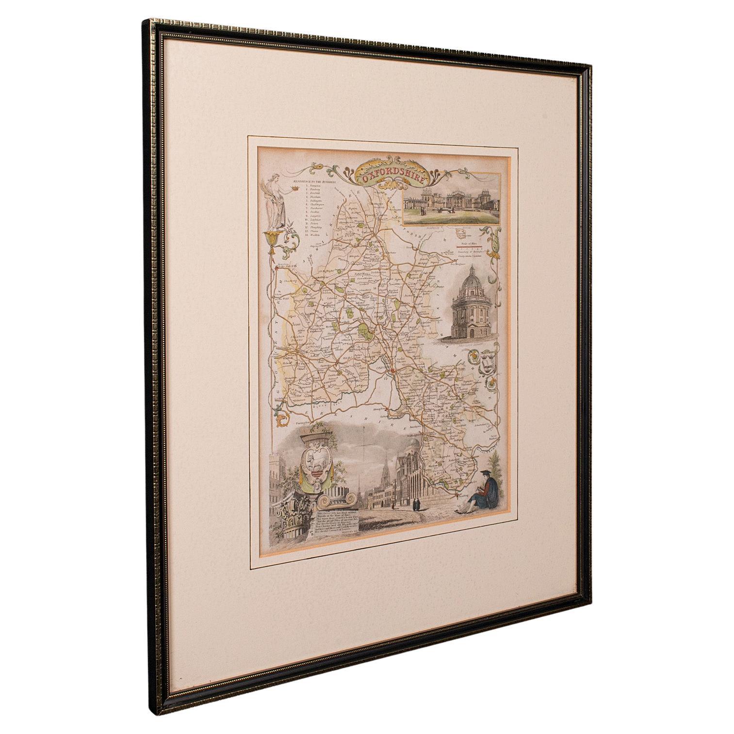
Items Similar to Antique Lithography Map, Oxfordshire, English, Framed Cartography, Robert Morden

Want more images or videos?
Request additional images or videos from the seller
1 of 10
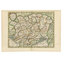
Antique Lithography Map, Oxfordshire, English, Framed Cartography, Robert Morden
About the Item
This is an antique lithography map of Oxfordshire. An English, framed atlas engraving of cartographic interest by Robert Morden, dating to the late 17th century and later.
Superb lithography of Oxfordshire and its county detail - perfect for display
Displays a desirable aged patina and in good original order
Fascinating Queen Anne period cartography, appealingly set within a quality, later frame
Coloured finish to the county borders and nameplate adds distinction
Annotated for major towns and villages, with detail given to Oxford, Abingdon et al
Marked for cartographer Robert Morden (1659 - 1703) to the decorative title panel
After the original, as sold by Abel Swale & John Churchill in the 17th century
Dressed to the rear with hanging cord for ease of mounting
This is a quality antique lithography map of Oxfordshire, with fine cartographic interest and of generous proportion. Delivered ready to display.
Dimensions:
Max Width: 52cm (20.5'')
Max Depth: 3cm (1.25'')
Max Height: 59.5cm (23.5'')
Map Width: 36.5cm (14.25'')
Map Height: 42.5cm (16.75'')
- Dimensions:Height: 23.43 in (59.5 cm)Width: 20.48 in (52 cm)Depth: 1.19 in (3 cm)
- Style:William and Mary (Of the Period)
- Materials and Techniques:
- Place of Origin:
- Period:Late 17th Century
- Date of Manufacture:circa 1700
- Condition:Wear consistent with age and use. Presented in very good antique condition.
- Seller Location:Hele, Devon, GB
- Reference Number:Seller: 248931stDibs: LU2645342378452
About the Seller
5.0
Platinum Seller
Premium sellers with a 4.7+ rating and 24-hour response times
Established in 2005
1stDibs seller since 2017
981 sales on 1stDibs
Typical response time: 1 hour
- ShippingRetrieving quote...Shipping from: Hele, Devon, United Kingdom
- Return Policy
Authenticity Guarantee
In the unlikely event there’s an issue with an item’s authenticity, contact us within 1 year for a full refund. DetailsMoney-Back Guarantee
If your item is not as described, is damaged in transit, or does not arrive, contact us within 7 days for a full refund. Details24-Hour Cancellation
You have a 24-hour grace period in which to reconsider your purchase, with no questions asked.Vetted Professional Sellers
Our world-class sellers must adhere to strict standards for service and quality, maintaining the integrity of our listings.Price-Match Guarantee
If you find that a seller listed the same item for a lower price elsewhere, we’ll match it.Trusted Global Delivery
Our best-in-class carrier network provides specialized shipping options worldwide, including custom delivery.More From This Seller
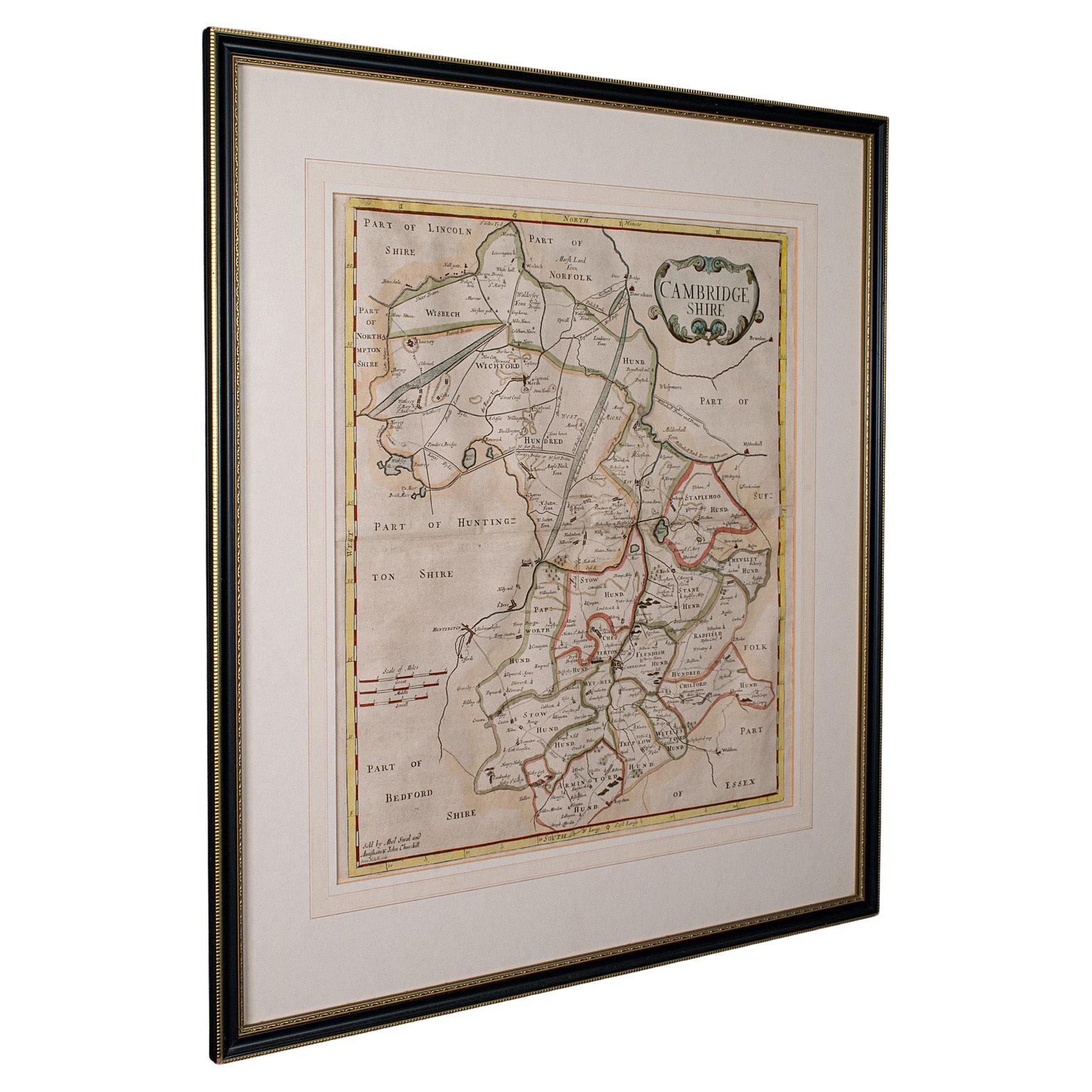
View AllAntique County Map, Cambridgeshire, English, Framed Cartography, Robert Morden
Located in Hele, Devon, GB
This is an antique county map of Cambridgeshire. An English, framed atlas engraving of cartographic interest By Robert Morden, dating to the late 17th century and later.
Superb lit...
Category
Antique Early 18th Century British Other Maps
Materials
Glass, Wood, Paper
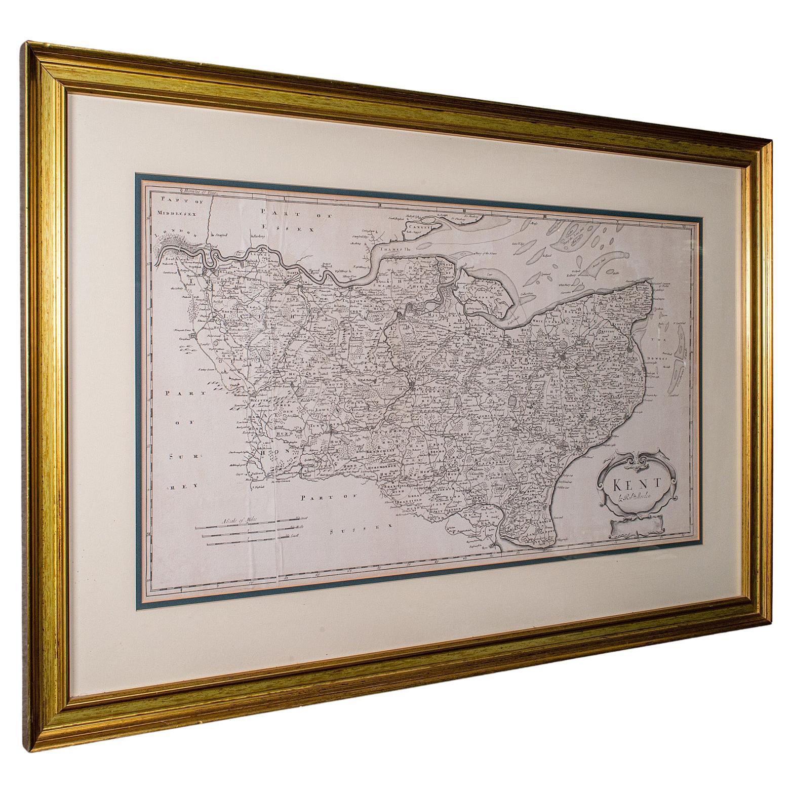
Large Antique Lithography Map of Kent, English, Cartography, Robert Morden, 1700
Located in Hele, Devon, GB
This is a large antique lithography map of Kent. An English, framed atlas engraving of cartographic interest by Robert Morden, dating to the early 18th century and later.
Superb li...
Category
Antique Early 18th Century British Queen Anne Maps
Materials
Glass, Wood, Paper

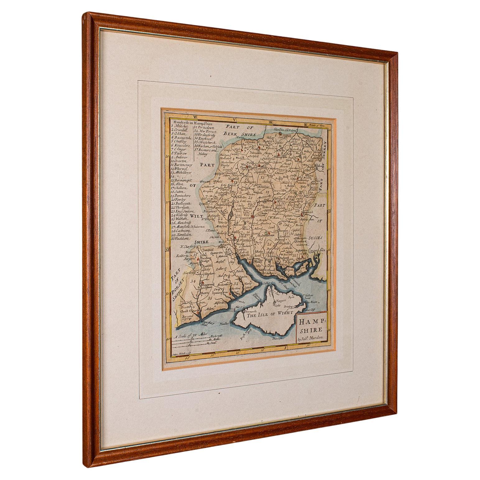
Antique County Map, Hampshire, English, Framed Cartography, Robert Morden, 1700
Located in Hele, Devon, GB
This is an antique county map of Hampshire. An English, framed atlas engraving of cartographic interest By Robert Morden, dating to the late 17th century and later.
Superb lithogra...
Category
Antique Late 17th Century British Other Maps
Materials
Glass, Wood, Paper

Antique County Map, Oxfordshire, English, Framed Cartography Interest, Victorian
Located in Hele, Devon, GB
This is an antique lithography map of Oxfordshire. An English, framed atlas engraving of cartographic interest, dating to the mid 19th century and later.
Superb lithography of Oxfo...
Category
Antique Mid-19th Century British Mid-Century Modern Maps
Materials
Wood

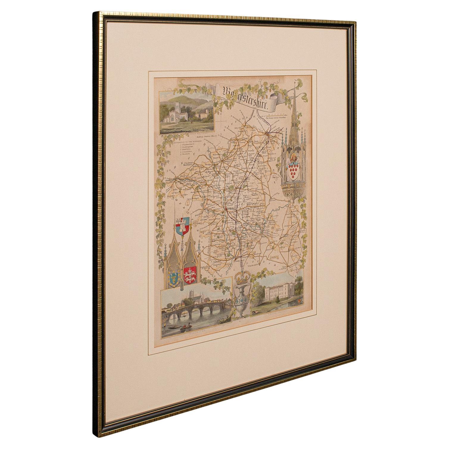
Antique Lithography Map, Worcestershire, English, Framed Engraving, Cartography
Located in Hele, Devon, GB
This is an antique lithography map of Worcestershire. An English, framed atlas engraving of cartographic interest, dating to the early 19th centur...
Category
Antique Early 19th Century British Regency Maps
Materials
Wood

Antique Lithography Map, Cumberland, English, Framed, Cartography, Victorian
Located in Hele, Devon, GB
This is an antique lithography map of Cumberland. An English, framed atlas engraving of cartographic interest, dating to the mid 19th century and la...
Category
Antique Mid-19th Century British Victorian Maps
Materials
Wood

You May Also Like
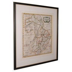
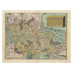
Antique Map of Herefordshire by Morden, c.1700
Located in Langweer, NL
Antique map titled 'Herefordshire'. Detailed map of the county of Herefordshire embellished with a decorative title cartouche. Three scales. Imprint of Abel Swale, Awnsham Churchill ...
Category
Antique 18th Century Maps
Materials
Paper
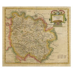
Antique Map of Herefordshire 'England' by R. Morden, 1708
Located in Langweer, NL
This antique County map of Herefordshire by Robert Morden was first published in 1701 in a work entitled 'The New Description and State of England'...
Category
Antique Early 18th Century Maps
Materials
Paper
$173 Sale Price
37% Off
Cartographic Tapestry: Antique Map of Asia Minor, circa 1640
Located in Langweer, NL
Title: "Historical Tapestry: Antique Map of Asia Minor, circa 1640"
Description:
This authentic antique map, created by Willem Blaeu and published in Amsterdam circa 1640, is a capt...
Category
Antique Mid-17th Century Maps
Materials
Paper

$890 Sale Price
30% Off
1584 Ortelius Map of Switzerland: A Cartographic Reversal
Located in Langweer, NL
This is a fine example of Ortelius' map of Switzerland from his *Theatrum Orbis Terrarum*, recognized as the first modern atlas of the world. The map is oriented with south at the top, which reverses the typical north-up orientation seen in most modern maps. It highlights significant geographical features such as Lake Geneva (Lemanus Lacus) to the right of the map and the Rhine river entering Switzerland near the center.
The *Theatrum Orbis Terrarum*, first published in 1570 by Abraham Ortelius in Antwerp, was groundbreaking as it compiled uniform maps with supporting text in a single volume, marking a departure from earlier collections of maps that were custom-assembled on demand. This atlas included a wealth of sixteenth-century cartographic knowledge, reflecting the extensive global explorations occurring after the discovery of America...
Category
Antique 16th Century Maps
Materials
Paper
$890 Sale Price
30% Off
1830 Map of Central England with Oxfordshire, Warwickshire, Buckinghamshire
Located in Langweer, NL
Title: Central England Map from Atlas von Europa – Published by Georg Joachim Goschen, 1830
Description: This 1830 German-language map, titled Britisches Reich – A. Kon: England...
Category
Antique 1830s Maps
Materials
Paper

Cartographic Elegance of the Mughal Dominion in a Hand-Colored Antique Map, 1705
Located in Langweer, NL
This original antique map titled “'T Ryk van den Grooten Mogol” by Nicolas Sanson from 1705 is an interesting historical artifact. It depicts the extent of the Mughal Empire in North...
Category
Antique Early 1700s Maps
Materials
Paper
Recently Viewed
View AllMore Ways To Browse
Churchill Antiques
Vintage 2 Tier Side Table
Vintage 2 Tiered Side Table
Vintage Armchair With Footstool
Vintage Bed Throw
Vintage Ice Maker
Wedding Rug
Wedgwood 18th
Whimsical Console Table
White Bench With Back
Windsor House Furniture
Woven Straw Chairs
Writing Desk Table Leather Inlay
1960s Silver Cutlery
1970s Chrome Console Table
1990s Leather Lounge Chair
Antique Austrian Porcelain Marks
Antique Coat Rack And Umbrella Stand